Wacky
-
Posts
39 -
Joined
-
Last visited
Content Type
Profiles
Forums
Events
Everything posted by Wacky
-
Unfortunately, I cannot speak to Lossless Scaling since I do not use it. However, looking at your post it seems like you might find a workaround looking at your multiple monitor configuration in DCS itself rather than Lossless Scaling. Maybe the following thread can offer some help? https://forum.dcs.world/topic/380773-monitorsetuplua-file-for-my-triple-screen-monitor/#comment-5709651 Good luck!
-
Well, how else would you like to connect the Germany Cold War to Syria and Sinai maps? Yup! Greece is needed to bridge the gap to the Syria and Sinai maps.
-
use wish list for desired features DCS: Balkans Updates
Wacky replied to OnReTech's topic in DCS: Balkans
Thank you for the heads-up, those images do look great so far! A few suggestions for later, regarding expansions and airbases: Expansion of the high/medium detailed area to the north-west (to include Piacenza San Damiano / Milano and Landsberg am Lech / Munich) Expansion of the high/medium detailed area to the south-east (to include all of Albania, Macedonia and a part of Northern Greece, similar to the Balkans map in Falcon 4.38) Expansion of the high/medium detailed area to the west (to include more of the Italian land mass, especially between Bologna and Naples.) Inclusion of air base Piacenza San Damiano (which saw frequent use during the Balkans air war) Inclusion of air base Landsberg am Lech (som 30 km west of Munich) which saw a lot of transport flights to and from Skopje (Macedonia) using German C-160s. Now, if you really want to make some people happy, you could expand the entire western side all the way out to Colmar / Freiburg im Breisgau (north-west corner) and Decimomannu (south-west corner). This would allow for connecting the Germany map to the north, including the International Flight Training School (as suggested by others), and might make some Swiss F-18 pilots quite happy along the way Good luck, and looking forward to your updates! -
DCS Su-35S MOD, from CODENAME FLANKER Community
Wacky replied to freebirddz's topic in Flyable/Drivable Mods for DCS World
Thank you, this looks absolutely fantastic! Dare I ask, what is your ETA for release? Can we still hope for 2025 or should we expect to wait until 2026? Thanks & keep up the great work! -
Yeah, I remember the use of Piacenza San Damiano appearing frequently in the news during the air war. Also, the Germans regularly had transport flights between Landsberg am Lech (near Munich) and Skopje (Macedonia) using their C-160s. I understand OnReTech's notice that they give their 2026 release deadline a higher priority than the expansion of parts of the map or the addition of airbases. Nevertheless, I would love to see an expansion of the high/medium detailed area to the north-west (to include Piacenza San Damiano / Milano and Landsberg am Lech / Munich) and to the south-east (to include all of Albania, Macedonia and a part of Northern Greece, similar to the Balkans map in Falcon 4.38). Also, it would be great to see more of the Italian land mass included into the high/medium detailed area, especially between Bologna and Naples. Needless to say, this theater will be high on my list when it will be released. Thank you for taking this on, OnReTech, and good luck with this project!
-
Cloud bugs - strange pattern, LOD edges
Wacky replied to SirJ's topic in Weather System Bugs & Problems
Thank you for getting back on this! ED Support has kindly helped in the meantime and disabling DLSS upscaling solved the issue in my case. Thanks again and best regards -
Cloud bugs - strange pattern, LOD edges
Wacky replied to SirJ's topic in Weather System Bugs & Problems
Alas, the issue with "anti-aliasing artefacts visible under some conditions when clouds are low on the horizon" appears to be back in the latest DCS update 2.9.17.12034! This is especially visible when the sun is low, on the horizon opposite to the sun in the F-16C free flight mission on the Kola map, or in the F/A-18C free flight mission on the Syria map. Zooming in (using the scroll wheel when the clickable mouse cockpit mode is off), the anti-aliasing artefacts disappear and zooming out again, they reappear. This seems to be independent of the visibility range setting and even with clouds set to "ultra". Please note that version 2.9.13.6818.2 does not exhibit this issue, so maybe this was reintroduced with core changes and/or new terrain additions in later versions. ED, could you please look into this? Thank you and keep up the good work! -
In the meantime, maybe the following information can be of use for those who like to do campaign and mission building?
-
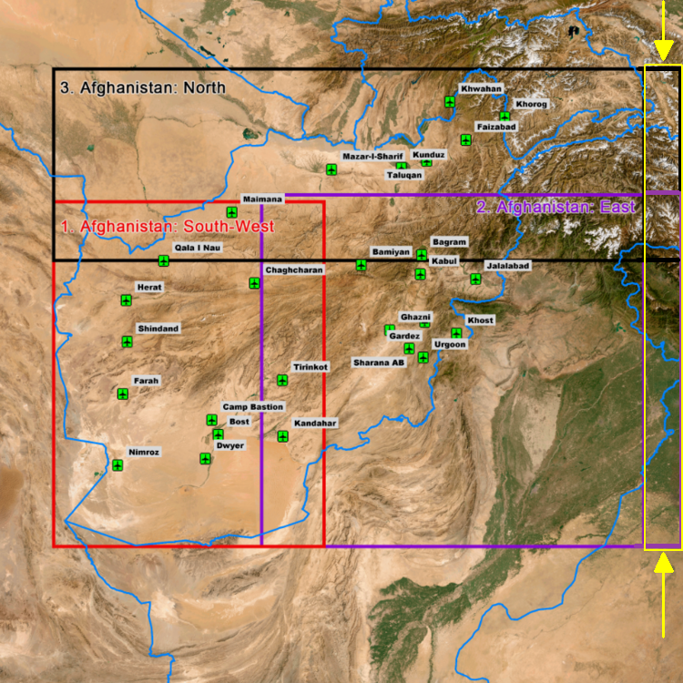
Kudos to ED! I am happy to see that the detailed area of the DCS: East Afghanistan map is now extended to match up with the eastern border of the DCS: North Afghanistan part. With the recent air battle between India and Pakistan over the Jammu and Kashmir as well as Punjab regions, if we could get another 100 km / 60 mi in the eastern direction to include Srinagar, Amritsar, and Jalandhar (depicted by the yellow rectangle in the image below), the map would be perfect to accommodate this entire scenario, as described here: Incredible Pakistan Air Force debriefing about India-Pakistan air battle So, it would allow for scenarios related to the Afghanistan theater and offer additional value of scenarios involving contested areas between India and Pakistan. How many of you would love to see that in DCS?

-
Nice shots! Depending on the satellite imagery source material used for the surface textures, strategically important areas may have been pixelated or blurred out by the imagery provider. You can see the same thing happening on Google Maps and others. Satellite imagery provided by national services may be a better way to go in this context - and of course, the best is to model those airfields / airports / installations in 3D!
-
Have you tried Compactor or CompactGUI yet? They're both on github and can be used to shrink the DCS footprint by 20-30% without noticeable performance hit.
-
Italy alone might only make sense in a WWII setting. However, combined with Ex-Yugoslavia/Croatia/Bosnia-Herzegovina/Serbia/Kosovo etc. - as seen in Falcon BMS with the Balkans theater - it might be more appealing to DCS and the community if set in the 90s?
-
Have you considered compacting your entire DCS folder? There are some tools available which allow for easy compacting, such as CompactGUI https://github.com/IridiumIO/CompactGUI Compactor https://github.com/Freaky/Compactor/? The latter allowed me to reduce the DCS footprint by 20-30%, at no noticeable performance cost. Your mileage may vary, of course.
-
It has been requested before, but on this occasion I would like to reiterate that it would be awesome, not least for our pilot friends from Denmark, if Skrydstrup Airbase in Southern Jutland could be added as well. Its geographic latitude is less than Copenhagen Kastrup and Malmö airports which are included, and it used to be an important F-16 base and essential part of the BALTAP command: https://en.wikipedia.org/wiki/Fighter_Wing_Skrydstrup https://en.wikipedia.org/wiki/Outline_of_the_Danish_Armed_Forces_at_the_end_of_the_Cold_War This would also allow for a more coherent inclusion of the airbases in Schleswig-Holstein. Thank you
-
Please give Schleswig-Holstein (Northern Germany) some love in Phase 3
Wacky replied to Lt.Seahawk's topic in Wish List
+1 And while you're at it, please include Fliegerhorst Husum (see https://en.wikipedia.org/wiki/Husum_Schwesing_Airport) as well which has seen substantial Fiat G-91 activity during the cold war era. Thank you!!! -
Thank you KarlRadek for pointing this out and providing so much detailed information! When modelling coal mines in more detail, please also include the lignite mining areas west and north-west of Cologne which has hosted vast coal mines during the cold war and up to this day: Rheinisches Braunkohlerevier (Wikipedia) Rheinisches Braunkohlenrevier - - Flächennutzung um 1980 (Diercke) Rheinisches Braunkohlenrevier - - Flächennutzung um 1980 - Nordrhein-Westfalen - Rheinisches Braunkohlenrevier - Landschaftswandel durch Bergbau. Source: Diercke These areas are already visible in the surface textures of the sim, so I hope detailed terrain mesh, 3D objects and structures will be added in the upcoming phase 2 or 3, as they are major landmarks typical for the region. Kudos, deep appreciation and gratitude to the developers, and please do keep up the great work!
-
+1000 Plus, the landscape and mountains would be an amazing addition.
-
+1
-
First of all, thank you for this wonderful addition to the DCS World! The pre-release, albeit of course still work-in-progress, looks very promising so far! Not sure whether this is an oversight: the airports Kassel/Calden Airport (EDVK, map sector NB) and Paderborn/Lippstadt (EDLP, map sector MC) seem to be missing, although they are indicated on the in-game raster map view and were opened in 1970 and 1971, respectively. They do not appear on the airport lists for phase 2 or 3, either, which seems a bit weird since the city of Kassel has been modeled in detail already. Some info on these airports: Kassel-Calden Airport (IATA: KSF, ICAO: EDVK) Paderborn/Lippstadt Airport (IATA: PAD, ICAO: EDLP) Maybe you want to consider including them in phase 2 or 3?
-
- 2
-

-
It seems the Eurofighter entered service in 2003, ie. obviously after the cold war. However as I remember, in addition to the Phantom, A-10s and Tornados were flying rather frequently in Germany back in the 80s.
-
+1 absolutely! I'd totally love to see Karup Airbase, too, but it seems to be a bit too far up north... Adding Skrydstrup and the area of South Jutland as you have marked on the map would be really awesome, not least for Baltic approach missions.
-
Good question! There is this video tutorial https://www.youtube.com/watch?v=bwzU3VKijoM which explains how you can create missions that span across adjacent terrains (case in point: Syria and Iraq). I would assume that you could extend this further to the Persian Gulf and/or Afghanistan terrains in the overlapping areas, and place a few tankers en route to ensure you have enough fuel to actually get there.
-
Strange looking textures in mountain villages
Wacky replied to skywalker22's topic in Bugs and Problems
Indeed. Keeping fingers crossed this will be addressed and enhanced when Afghanistan: North map is developed, although the above mentioned areas seem to be part of Afghanistan: East as well, according to https://forum.dcs.world/topic/346038-dcs-afghanistan-faq/ -
Strange looking textures in mountain villages
Wacky replied to skywalker22's topic in Bugs and Problems
... or they could cover the flat ground texture with some 3D vegetation like bushes and trees to make the scissor-cut edges less apparent. Obviously the green areas in the satellite imagery are covered by vegetation in reality.