Wacky
-
Posts
39 -
Joined
-
Last visited
Content Type
Profiles
Forums
Events
Everything posted by Wacky
-
+1 IMHO the impressive mountain ranges of the Hindu Kush and western Himalayas really are what sets this map apart from the other DCS maps. It would really be great if the developers could show the terrain mesh and surface textures as much love as they can, especially in the eastern half of the North Afghanistan area, as outlined in black on https://forum.dcs.world/topic/346038-dcs-afghanistan-faq/, and all the way up to the border with China:
- 1 reply
-
- 2
-

-
Nealius likely has a point here. These kind of scenic videos are often given more "punch" saturation-wise in order to impress more. Without first hand experience, though, it is difficult to know what colors should look like and how much of an impact sand and dust do have on overall color saturation of the vegetation. Having said that, as a simulation which strives to be realistic, it would make sense for DCS terrain developers to keep the default color rendering as close to real life as possible. Anyone wishing for cinematic effects or different color rendering can choose one of the color grading presets in the game settings, or use Reshade to create a custom profile.
-
Static and terrain objects must be fix
Wacky replied to =BK=Solovyov [27]'s topic in Bugs and Problems
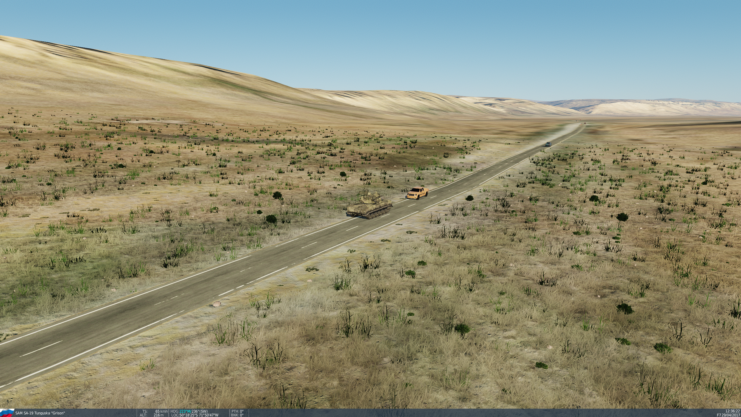
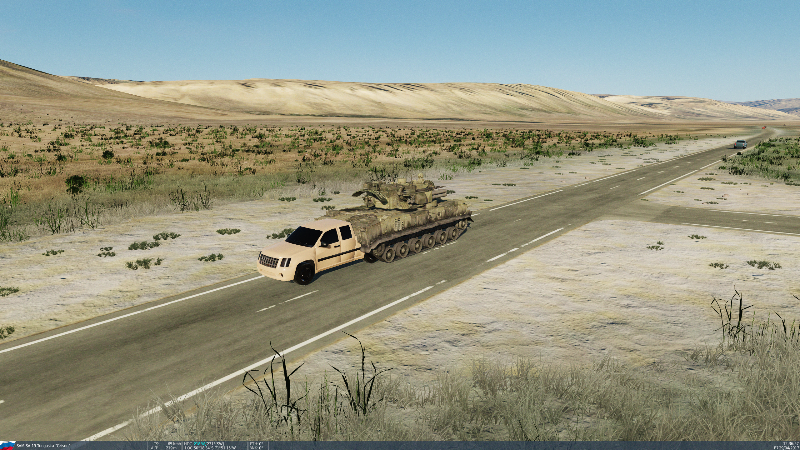
Not sure if this is actually a terrain issue or unit-related, but I can confirm that the car-in-car issue also seems to happen with moving objects, as in the following "car/tank drive-through" scenario. The tank appears to be the offending object here, as it insists on driving on the left hand side of the road, even though Argentina is a right-hand-drive country (observed near El Calafate):
-
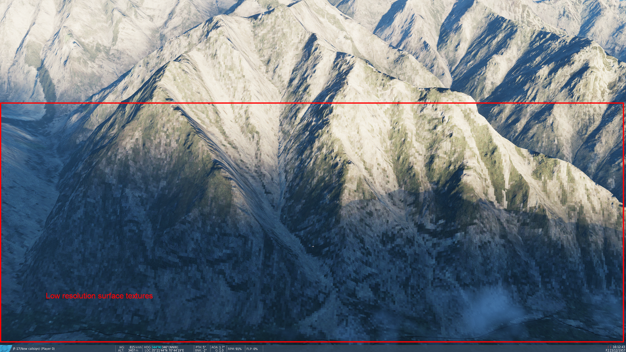
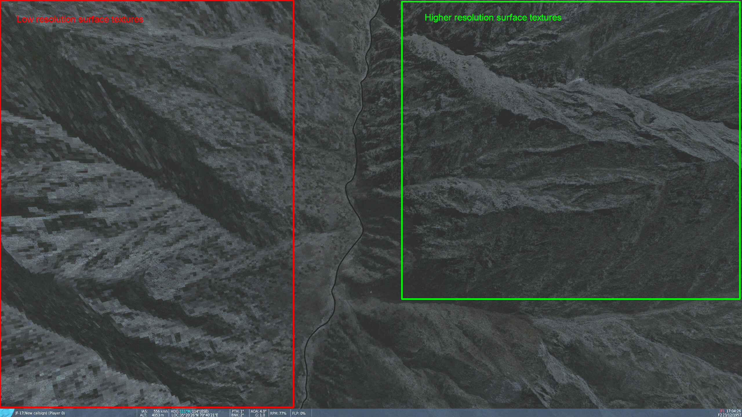
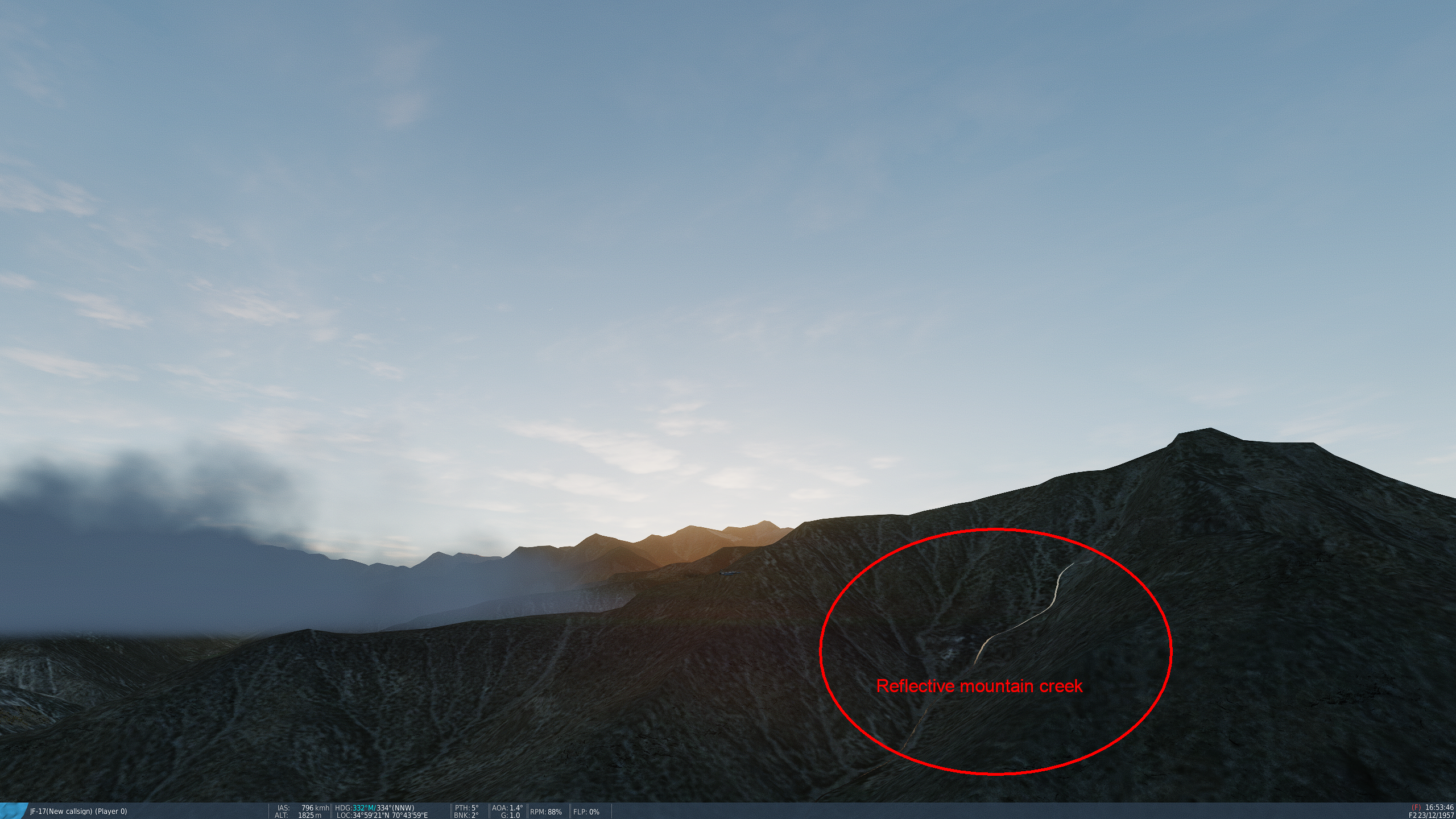
This may be part of the upcoming North Afghanistan map, however I want to report this anyway as it also affects the East Afghanistan map. In the current DCS release 2.9.13.6818, sector XE in the northeastern part of the Afghanistan terrain exhibits low resolution, checkerboard-like surface textures throughout a substantial part of the mountain area (you may have to zoom the screenshots to 100% to view the issue): On the mission editor map, the difference in texture resolution can easily be viewed by switching to satellite imagery and zooming in until the map scale indicator shows 600 m or below. Furthermore, creeks rendered as water on mountainsides can become unnaturally "shiny" under certain lighting conditions - even when in the shadow of the mountain - as their surface reflects the sky colors. This may affect all creeks on mountainsides throughout the map: Also, as already has been reported by others, there seem to be base mesh / altitude issues with rivers throughout sector XE and possibly adjacent sectors. Apart from the above, the ambience and feel of the terrain is awesome and a joy to fly in. Keeping my fingers crossed that you will bring the quality of the entire mountain area east and northeast of Kabul and Jalalabad right up to the Chinese border up to par, as this area offers spectacular high-altitude mountain terrain truly unique among the available DCS maps. Thank you for keeping up the great work!
-
- 1
-
-
The map and aircraft load fine, however in the quickstart free flight mission some weird flight control behaviour occurs. It is as if it develops a life of its own: the trim setting seems to jump randomly, and sometimes the stick movement along the pitch or roll axis seems to initially go in the opposite direction or not respond properly. The issue also appears when the weather is set to clear sky and 0 wind. I've checked the joystick controls and calibration as well as the profile config for the aircraft, all of which are confirmed ok. NB. this issue only occurs with the F-16 in the quickstart free flight mission that comes with the map! Loading this mission into the mission editor and flying it with another aircraft does not exhibit this strange behaviour, so this does not seem to be related to atmospheric thermal conditions, either. Also, F-16 flight control works flawlessly in the other maps, as well as on the Afghanistan map when a new mission is created from scratch. Good luck in figuring that one out, and thank you for keeping up the great work on this wonderful terrain!
-
Love this map! Just a small detail, but if the developers would give the North Cape area some love, it surely could enhance realism. As of now, this spot seems to be represented by just one simple building on top of the hill. IRL, there are several structures as depicted on the these photos: Aerial photo of North Cape area Grid globe structure at North Cape ArcGIS World Imagery View Google Satellite View Google Street View A big thank you and kudos to the developers, please keep your efforts which are greatly appreciated!
-
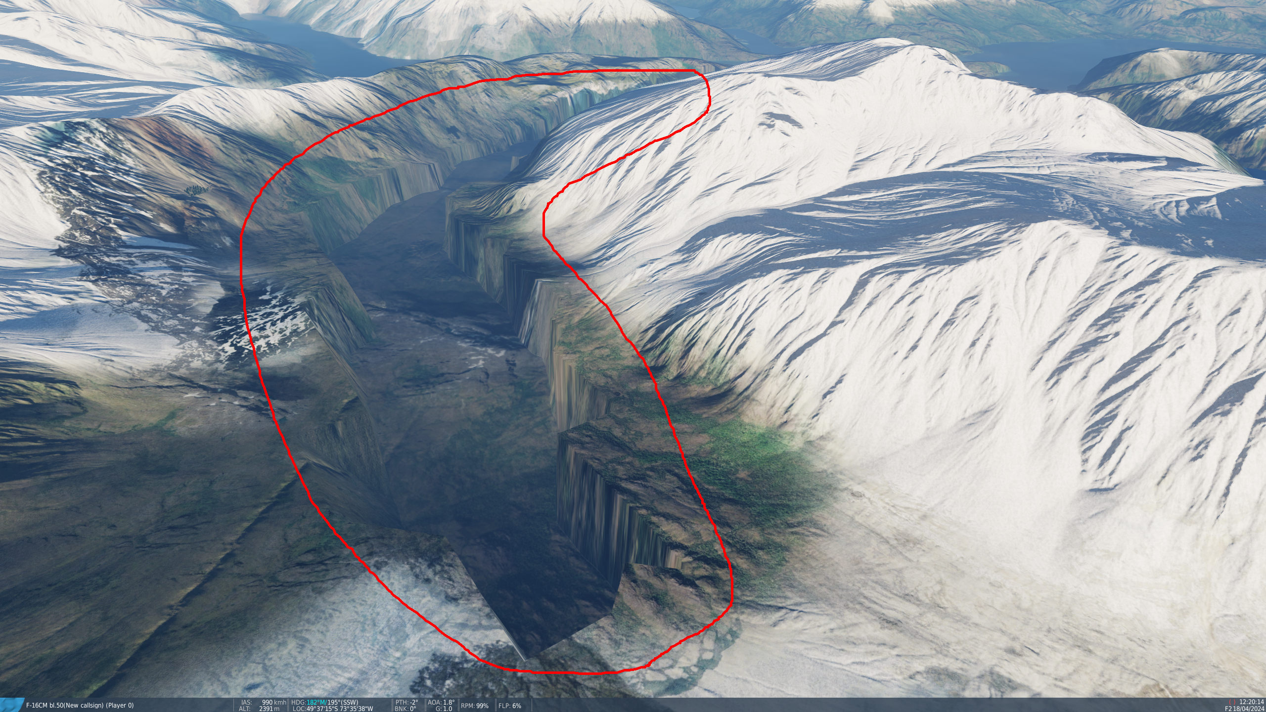
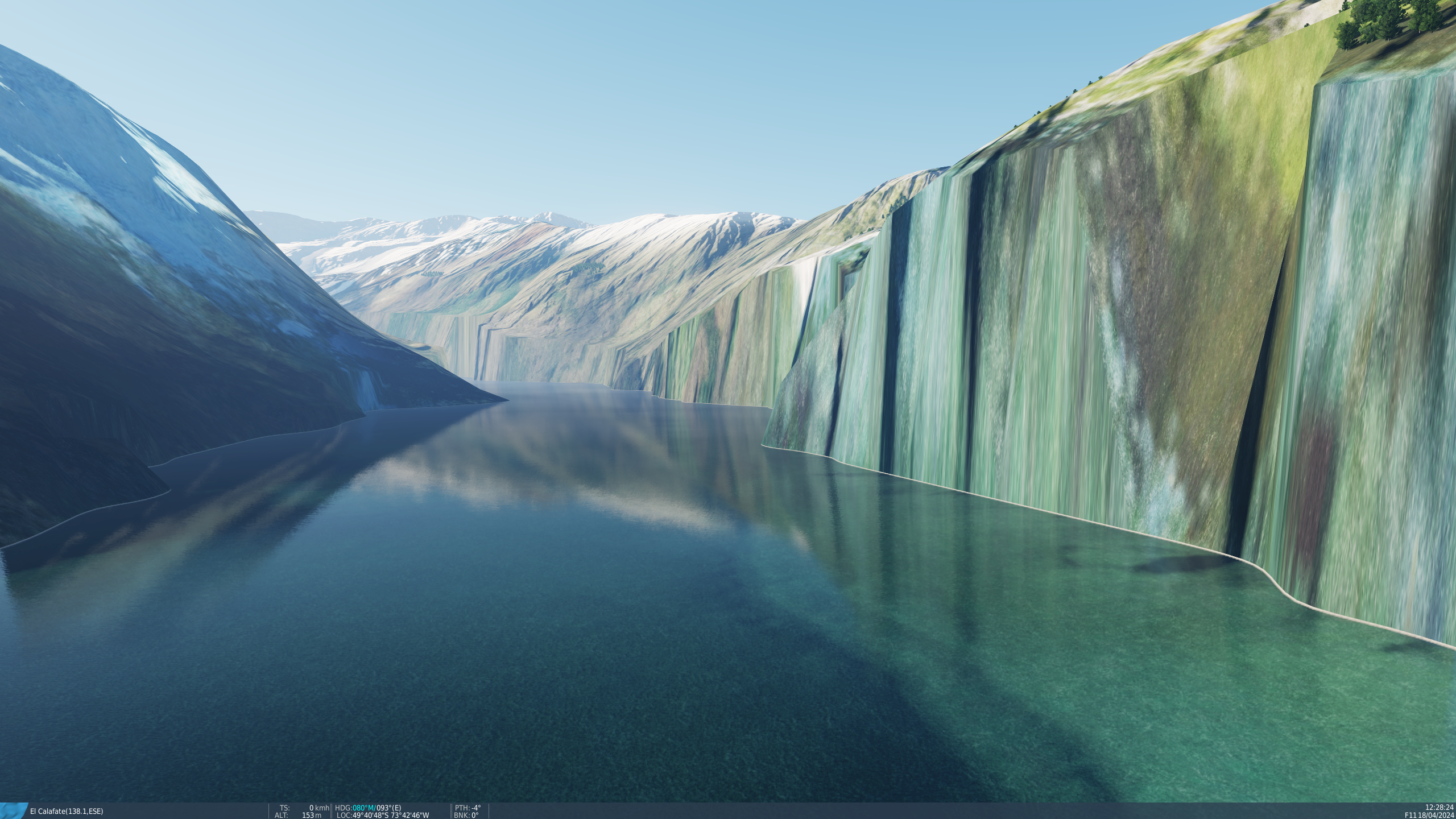
(This post has been slightly edited and reposted from here, as it might be more appropriate in this forum) Looking forward to the latest announced enhancements of the South Atlantic map, I hope the mountainous regions (like for example in the area of sectors WL-XL-WK-XK between Cerro Torre and Fiordo Falcon to the NW of Parque Nacional Los Glaciares) will receive a more detailed terrain mesh. There are quite a few spots where the DEM data does not seem realistic, both visually and also compared to OSM SRTM elevation lines. Especially for the part of Fiordo Falcon that is at the centerpoint of sectors WL-XL-WK-XK (see attachments for reference). Water elevation levels also seem to be a bit above of what they should be for a few glacier lakes, for example in the eastern part of Reserva Nacional Los Glaciares. Of course, a bit higher resolution textures would be nice, too. Apart from these, I salute the South Atlantic map team for the progress made since the initial release of the map. Thank you and keep up the good work!
-
Absolutely looking forward to this one! Hopefully the mountainous regions (like for example in the area of sectors WL-XL-WK-XK between Cerro Torre and Fiordo Falcon to the NW of Parque Nacional Los Glaciares) will receive a more detailed terrain mesh. There are quite a few spots where the DEM data does not seem realistic, both visually and also compared to OSM SRTM elevation lines. Especially for the part of Fiordo Falcon that is at the centerpoint of sectors WL-XL-WK-XK (see attachments for reference). Water elevation levels also seem to be a bit above of what they should be for a few glacier lakes, for example in the eastern part of Reserva Nacional Los Glaciares. Of course, a bit higher resolution textures would be nice, too. Apart from these, I salute the South Atlantic map team for the progress made since the initial release of the map. Thank you and keep up the good work!
-
JAS 39C Gripen Community Mod
Wacky replied to whisky.actual's topic in Flyable/Drivable Mods for DCS World
Just in case someone feels inspired to continue developing the JAS-39 Gripen Mod and would consider the newer D/E variants: Swedish Brand New Fighter Jet Shocked The World! https://www.youtube.com/watch?v=YCYNVKBgnPU -
On ED's Iraq terrain product page for the Iraq terrain, it is stated: Features Coming During Early Access <..> Future Regional Expansions: Planned extensions into neighbouring regions, further broadening the operational theatre. A combination with the existing Persian Gulf terrain would make a lot of sense and be absolutely fantastic!
-
It would be great if they could provide an option to combine both Iraq and Persian Gulf into one single terrain for those of us who have licensed both. It would be awesome for long range missions as back in the day with Microprose's F-19 Stealth Fighter and also this: Persian Gulf Upgraded Map Template - Project GRIDS On their product page, ED state the following under Features Coming During Early Access: "Future Regional Expansions: Planned extensions into neighbouring regions, further broadening the operational theatre." So there seems to be a chance that this actually may come true one day... fingers crossed!
-
Thank you ED for your continuous efforts and updates. The latest version is a real joy to use due to its visual fidelity and smoothness. It would be even greater if you could find a way to ensure FC3 backwards compatibility so that third party / community aircraft mods based on FC3 parts could still be used in future versions of DCS. Thank you! Regarding the upcoming Instant Action Generator, could we please have configuration settings to allow for easy setup of simple missions with only few enemy units, or with enemies spawning over a (random or potentially configurable) extended period of time so that they could be dealt with in a chronological manner rather than being confronted with them all at once? I very much like the mission configurations from classics like the MicroProse simulator series - which of course were all single player back in the day - where the number of enemy aircraft and ground units to be dealt with at the same time was more easily manageable, and I do feel overwhelmed with the sheer amount of active air and ground units often found in DCS generated missions. Thanks & keep up the good work!
-
F-22A Raptor mod enhancement mod
Wacky replied to Nightstorm's topic in Flyable/Drivable Mods for DCS World
Here too I have "seen the light" after updating from an older F-22A mod version to v3.0. It seems the file F22_CANOPY_GLASS_NRM.dds is missing in the v3.0 cockpit textures located in <username>\Saved Games\DCS\Mods\aircraft\F-22A\Textures\F-22A_Cockpit.zip Adding the missing DDS from the previous version of the F-22A mod to the v3.0 cockpit texture ZIP file mentioned above solved the problem.