ldnz
-
Posts
116 -
Joined
-
Last visited
1 Follower
-
investigating Bombing solution seems to use Barometric Altitude only
ldnz replied to ldnz's topic in Bugs and Problems
This matches my testing too, no DTC and laser is clearly used (see slight jumping around in solution as laser passes over objects), but with a DTC loaded its back to barometric. -
investigating Bombing solution seems to use Barometric Altitude only
ldnz replied to ldnz's topic in Bugs and Problems
I tried in a fresh mission without any DTC setup (single waypoint placed, airstart, bombing mozdok) and it looked very accurate. Tried an old mission (pre patch) and its still falling short.. resaved that mission and I think we're ok now. I'll do some more testing later -
investigating Bombing solution seems to use Barometric Altitude only
ldnz replied to ldnz's topic in Bugs and Problems
Did a quick test and saw exactly the same as previous patch - bombs consistently 100ft short. No response indicating laser was doing anything (ie a2g gun with laser shows range jumping around a bit as you'd expect) -
reported KA-50 ABRIS - map not scaling with symbology
ldnz replied to MortalMando's topic in Bugs and Problems
Yeah this stopped me flying the ka-50, too annoying and confusing to glance down only to find the map is completely wrong. -
Yes, if set to player or client
-
Its a pretty cool system if you know expected range and altitude of your target. Bit out of touch but doesn't the Mirage F1 have a similar mode?
-
This is great practice, helping me get my head around the radar. Love it, thanks!
-
investigating Bombing solution seems to use Barometric Altitude only
ldnz replied to ldnz's topic in Bugs and Problems
Could we please get some confirmation? In the current public build there is obvious huge barometric altitude input, and no evidence of using the laser when bombing. Is this intended (and can more information be given on how to deal with it), or a bug? -
investigating Bombing solution seems to use Barometric Altitude only
ldnz replied to ldnz's topic in Bugs and Problems
Interesting, that makes sense for toss bombing -
investigating Bombing solution seems to use Barometric Altitude only
ldnz replied to ldnz's topic in Bugs and Problems
Thanks, but which part of the calculation? Just density? Right now it appears only barometric altitude is used in the slant range calculation, not laser -
In opt mode, a2g, in a dive with a good steady solution bombs appear to always fall short. In active pause, the only thing that appears to affect the indicated slant range is the altimeter setting, laser makes no difference. It appears that radar altimeter and laser aren't being used for slant range calculation, only baro alt. Unsure, but in previous mission in mountainous terrain I found a2g cannon with laser (I think, but altimeter would have been no use) to be pinpoint accurate, so possibly just not right with bombs. LastMissionTrack.trk
-
Yep, with no idea how barometric/radar/laser ranging is supposed to interact, let alone whether (ED known) bug fixes have been delivered yet its pretty tricky to proceed.
-
I tried this on Nevada and saw similar. I was trying to zero the altimeter (for Groom Lake QFE) and found that my bombs were miles out and I go NOLA warnings. Also using pre-desig when set with altimeter far from QNH I noticed the desig symbol altitude is wrong. Had A for laser on the hud, but it seems almost like only barometric altitude is being used (in a dive so probably too steep for radar?) not laser range
-
Yep, my design was as close to a paper approach as I could get while still being usable in VR - so although it has the slide rule, it will do the basic calcs for you as well. But no gps, everything is manual, POI, sam locations, the lot. Fixes are placed by double tapping where you think you are - so if you don't plan well with good landmarks its easy to misjudge and get lost. I've found I can comfortably get TOT within +/- 10 seconds with this approach, with or without INS (though INS more useful higher you get/more cloud cover/night - blue ticks are at 5nm (or 5km if in metric) from waypoint so you can glance down and see where you should be up to compared to INS distance to go, and purple ticks are minutes to go as planned. I was improving fix logging and got this flight through South Atlantic in a gazelle with its tablet disabled and no INS that was cool image.pngimage.png

-
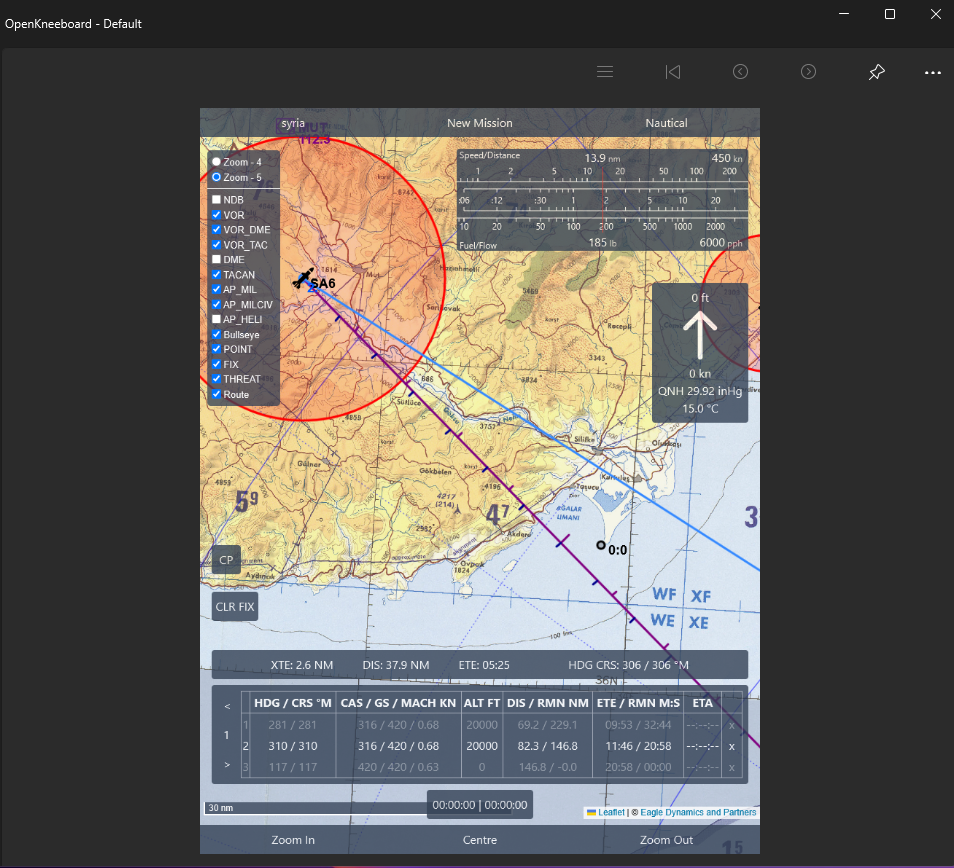
I kinda built this sorta thing for my own use - a simple little server app that pulls the map tiles and navaids from DCS, and is designed for manual, warbird, helo, F-4 style nav. I use it within openkneeboard with a wacom tablet. You can double tap to select a point and use it as a waypoint, threat mark or a nav fix, or can use the new alt-click in the F10 map and then copy to clipboard to get coords easily from DCS. If anyone is interested I've been meaning to polish it up for an opensource release.null