
DD_Fenrir
-
Posts
2050 -
Joined
-
Last visited
-
Days Won
3
Content Type
Profiles
Forums
Events
Everything posted by DD_Fenrir
-
I suspect - I reiterate that what I am about to say is a supposition - that some flight surface airloads are not yet modelled fully or at all. There is precedence for this; Spitfire rudder airloads were absent on initial EA, as were - IIRC - the P-47. It maybe that this feature is WiP.
-
 If suggestions are being taken, I would add that the following would be an excellent QoL improvement, plus be more realistic: User selectable option to temporarily disable catapult 1 & 2 and allow parking on Cat 2 And if it would be possible when parking to have the directors position the aircraft the correct orientation and then for an automatic function push the aircraft back, even if would be a sudden snap rather than a gradual animation, I think would be better.
 -
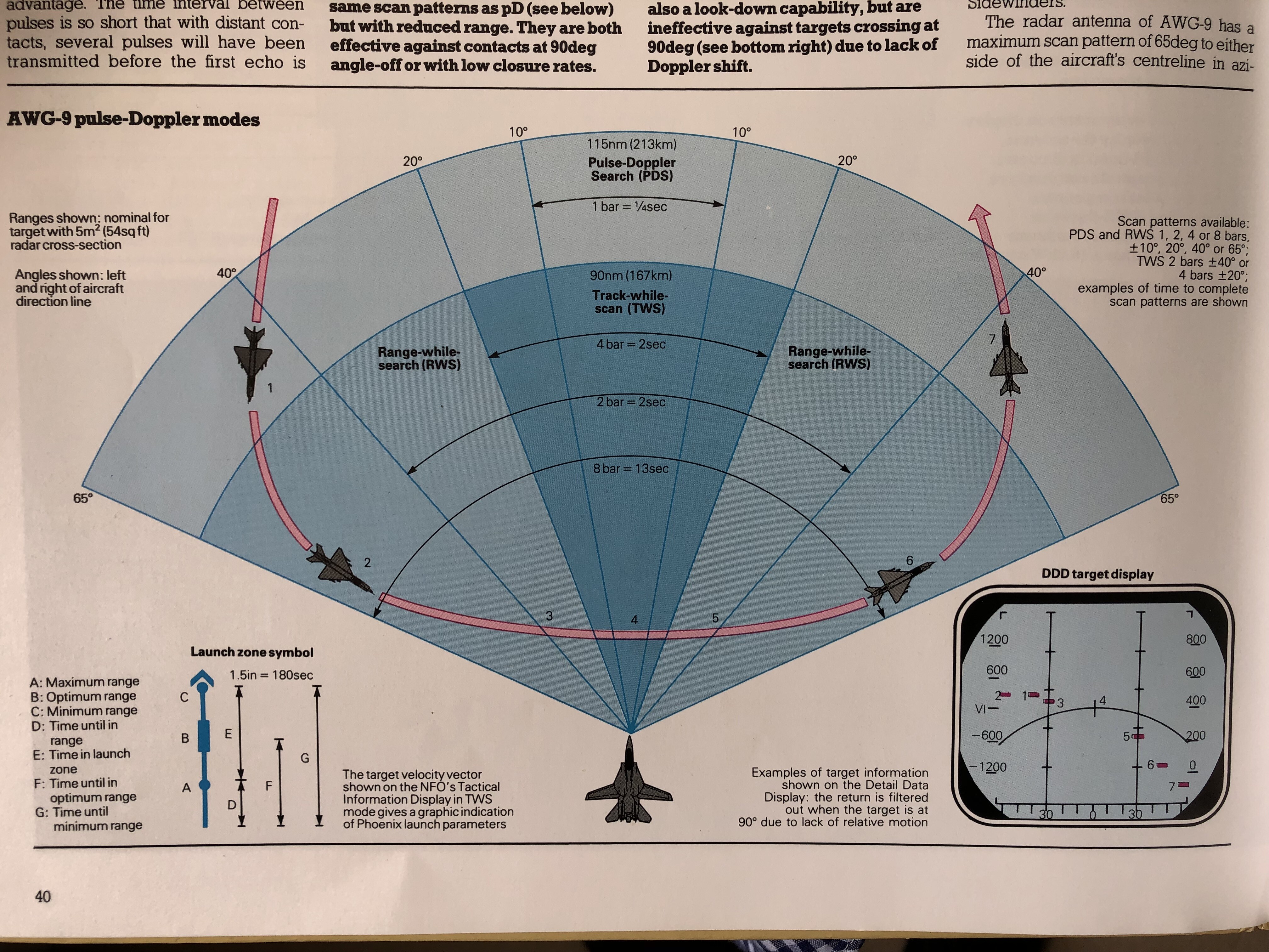
The book my Father’s work is in was published in 1985. Given that he is not an expert in radar systems or avionics, I suspect the Stevenson book material was used as reference and redrawn. Salamander produced a large variety of military aviation books during the 80’s; it would not surprise me that these drawings would be leveraged across other tomes, or sold to other publishers for use.
-
For clarity here are the originals with further details and annotations that explain some of the shown information, including a representation of the DDD showing how the MiG-21 referenced bricks should appear:

-
My Father and his graphic design business partner drew these originally for the book “Modern Fighting Aircraft: F-14” published by Salamander.
-
Dogfighting is really getting me annoyed
DD_Fenrir replied to Alphagamer1981's topic in DCS: Spitfire L.F. Mk. IX
Wow. Gaslighting? That’s pretty <profanity>ty behaviour. But what more can we expect from angry man boy wehraboos? -
This isn't FIFA 2025. Or farming simulator. The "grass" object has to pretend to be a multitude of plant types depending on the texture underneath; this same object stands in for wheat or barley on crop fields and neatly mowed grass on football fields and airfields. To be fair I think they've managed to strike a plausible balance.
-
Eh? There's no annular radiator on a Sea Fury; the Centaurus is a radial, cooling the cylinders by direct airflow.
-
-
That Garret looks brilliant; only issue is that it never wandered very far from the Worsborough incline (which is halfway between Sheffield and Leeds) - that's almost 150miles North of the most northerly parts of the Normandy map! I would suggest that a Southern Railway mixed traffic type would be more appropriate; perhaps an N Class mogul?
-
Tips for keeping the energy for dogfighting
DD_Fenrir replied to WildeSau44's topic in DCS: F-14A & B
Also have a gameplan for each enemy aircraft type you encounter. Know what strengths or weaknesses you can deny or exploit in both your opponents jet and your own. Fuel and ordnance weight will also factor into what you can achieve so keep these in mind. For example, in an F-14B vs a MiG-29 choosing a 2-circle fight is not usually a great idea as under most circumstances a good MiG-29 will at least match or better your best turn-rate; this means a 1-circle is probably a better option... However, this generally means you'll need to get slower than the bandit and you'll be sacrificing kinetic energy to do so at the merge. A smart driver will use the vertical to drive their speed down to their best radius speed whilst using a gain in altitude to gain PE and mitigate the overall loss in energy. That said, if you can get your nose on faster, you can drive bad decisions from the opponent, which if you are able to expolit can compound their problems and allow you some good follow-on BFM options, if not an immediate weapons employment opportunity. -
Or, let's not and let ED concentrate on progressing their proprietary software that they understand better than anyone else in a way that suits their development roadmap that suits them best. Christ, it takes long enough for new features to mature enough to be brought to the community and even then it can take some time for these to become robust and stable. You want to introduce a system that will inevitably extend these timescales?!? No. If you add an unofficial mod and it breaks the game, guess who's responsibilty that is... YOURS. You can sit and wait as the modders figure out how to make their mod re-compatible, if they are still active. If they aren't you are SOL. You did not pay for it, you are not owed a damn thing, especially not by ED. ED have acknowledged the great work done by some modders, enabling a fairly simple and segragated way of implementing them with minimum risk of breaking the game. They have even integrated some into the base game assets; however this does not make them liable and they certainly should not waste $$$ or time (frankly they are synonymous) on appeasing impatient and indignant unofficial Mod users.
-
The Legit Discussion for PTID on the F-14B and late F-14A
DD_Fenrir replied to SkyhawkDriver's topic in Heatblur Simulations
Your mistake is in assuming your entitlement to that knowledge. Best get noshing old bean. -
You assume a lot. Sure, Jester is lacking some capability that a human RIO would bring but at this point are you surprised? This an AI developed by a flight sim developer, not a dedicated developer of AI; that it operates the basic RIO functions as well as it does is a credit to Heatblur. And if you work with Jester and understand it’s limitations it is an eminently usable and useful system; is it fail safe? No, but 9 times out of ten it does the basic functions required by a RIO to perform intercepts. Ultimately you expect too much; would Jester benefit from adjusting scan patterns to accommodate data link contacts, sure but if it where that simple don’t you think it would have been done by now? There’s a vast amount of abstraction, extrapolation and supposition being performed in the human brain of a RIO during an aerial engagement, and expecting an AI developed for a home PC entertainment software to even begin to replicate the deeper levels of actual human cognitive processes is frankly unrealistic. The fact is Jester, when used properly is sufficient. I strongly suspect you are using it poorly and expecting it to have capabilities that mitigate for your suboptimal understanding of how to get the best from it.
-
We're done. We've told you what you need to provide in order to first effect review and thereafter - potentially - change. EVIDENCE. And no, "trust me dude, PvP servers don't like Phoenix" does not count, as surprising as that may seem to you. Demonstrate the problem, with repeatable examples in various .trk files. On top of that actually provide data for examples of what it should be (if you can find it). You have done literally zero of the above and as such your legitimacy is at rock-bottom and from this point forward you will struggle to make anyone in this community even bother to listen. So, before you yet again basically repeat exactly what you wrote in your OP just worded slightly differently, let me remind you that simply repeating the same thing over and over and over again doesn't actually make it objectively true. Repeated testing of evidential data against a hypothesis does. Which you have done none of.
-
Look, I am not saying you are automatically wrong, but there's a heap of conjecture, supposition and "I feel" in your position statement. None of this provides meaningful data to support your position. If you think something is wrong, bring a good selection of .trks (some tacviews too can help but .trks are better) demonstrating the behaviour and where you think the problem lies. Then we can talk. It doesn't help that you're essentially coming from the opposition and accusing the F-14 of having unbeatable missiles - we in the DCS: F-14 community are only too aware of the limitations and weaknessess of the Phoenix and are rather cynical when OPFOR players come in here and make unsubstantiated claims; if you're gonna do it the burden is on you to provide the proof, so bring evidence. Regards ECM resistance, this is not unique to the Phoenix, as as far as I can tell, no A2A missiles in DCS, whatever the nation/alleigance, seem to be even vaguely affected by jamming, as the DCS noise jammer is a rudimentry simulation at best, being burnt through by Air Interception radars at ranges well outside the Rne of most of the A2A missiles in DCS. Also, in real life, the AIM-54, even the -A, had the ability to automatically switch to home on jam mid flight should the track file be swamped so in RL switching on jamming might not be the best idea; in DCS if you're approaching a bandit who has a AR/SAR missile with HoJ capability it is a bad idea to have your ECM on under 20nm; ask me how I know... As an OPFOR player, if you're fighting F-14s carrying AIM-54A and you aren't dropping into the notch at regular intervals as you try and close to your effective missile range, then you're doing it wrong.
-
Nothing like a well evidenced argument. Oh, wait…
-
Sure Voodoo, head along to https://dangerdogz.com/forums/ and register; once completed, then head to https://dangerdogz.com/forums/forum/127-recruitment/ to announce yourself.
-
Hello fellow DCSer! If you're looking to join a multiplayer squad with: a strict training regimen and attendance criteria ranks, medals and an autocratic hierarchy with an over-inflated sense of elitism and their own importance Then steer well clear of the DangerDogz! We are a relaxed, happy-go-lucky bunch of fellows whose primary goal is enjoyment in combat flight simming and the realisation that that can take many forms. You turn up when you are able to attend - cos real life get's somewhat inconvenient at times - with nothing more than a forum post from the rest of us inquiring as to your health and well being if you're not around for a while. Training is an impromptu affair with some of our experienced guys happy to help out when ever is convenient to you and them. You learn at a pace that suits you and still get to fly combat ops with the squad. Can't fly formation? No worries! Neither can most of the Dogz! Same for AAR - if you wanna learn then we have some guys who can give you pointers, but there a no minimum requirements - save one. Be a decent kind of fellow. Whilst we have a preference for things Western in both jets and props, we have guys who'll climb into anything with wings and there's always someone willing to talk you through the finer points of operating a particular plane, or at the very least is prepared to find out with you. And if it's a Spitfire, P-51, Bf-109, Fw-190, Sabre, A-4, A-10, Tomcat, Hornet or Huey then you'll likely be talking to me and I'm more than happy to do some 1-to-1 training to get you setup and airborne as soon as possible. That's it. We fly DCS 'officially' on Monday & Thursday Night Euro and USA time zone, other nights being dedicated to other contemporary Combat Flight Sims. That said, you'll often find DCSers moonlighting at other times and I for one am always prepared to flout the official schedule for a bit of DCS goodness. We have players from all over the world, with healthy Canadian, US and UK contingents but also an Aussie, some Dutchmen, Germans, Croations, Romanians, Swedes and Norwegians. Whatever time you are able to find in your life to strap into a DCS cockpit, chances are some of our Dogz will be able to join you. Drop by, check us out, and say hello. If you think you and the Dogz might be a good fit then simply say so and we'll get you on the roster and flying along with us in no time. We look forward to hearing from you!
-
When adjusting the sight all you are doing is moving the horizontal ranging bars to provide a larger or smaller gap to give you some reference to your range; as far as I am aware there is no alteration of the vertical position of the reticle to account for any changes in the ballistic drop based on a change in range. Ultimately I keep it at the convergence setting so that if an opportunity for a sneak attack from a bandits low six presents itself I can know when the best moment to fire is to land most of my rounds in a concentrated spot. At all other times the gunsight settings are practically useless and I ignore them.
-
From what I understand LPI radars essentially broadcast static but in that white noise certain select and very tight frequencies are encoded and somehow patterned in a way that only the broadcasting emitter can decipher when the signal returns.
-
Fair point, however... You and I both know that a an ALR-45 is only half the equation when it comes to defining the early A. Ask yourself why were they developing an ALR-45? It clearly seems like there was an assumption at HB, pre-release that F-14A = ALR-45 and F-14B = ALR-67. It's an easy one to make when reading a lot of the general history stuff on the Tomcat. It so often states that the F-14B was delivered with new engines and a better RWR suite, but rarely states that the -As were upgraded to this new RWR also. Besides:
-
You act like they aren't; maybe it's not on a timescale to your liking but it's on a timescale that keeps them viable as a business. Whose in a better position to determine which workflows will result in a solvent company, Drac, you or them? The early A variants, yes, essentially. The product as initially advertised stated that both the A and B variants we were getting were from the mid-90s. If you brought it then, you are potentially (pending release of the early-As) getting more than was advertised. If you purchased later on the information that the early-As were going to be included in the modules development then, ok, I'll concede you might be disappointed by the timescale, but if you're sole reason for finally buying in is because you have a hard-on for Tomcats with gun gas purge grills rather than part-venturi then: You are a connosieur You therefore have a level of passion, knowledge and understanding that reflects a better than average intellect That level of intelligance should help you appreciate you are part of a minority, a niche, within a niche within a niche It should also help you appreciate that it is highly doubtful whether your little clique of early-A afficianados (most of whom would probably have already purchased the Tomcat, because, well, Tomcat!) suddenly buying in now will come close to cover the further development costs. Ergo, and given that HB has never baulked from being honest about what was initially included, been transparent regards their later intention to include the early As, shown some development progression prior to work on the F-4 and stated repeatedly that work is still happening but other priorities have had to take precedence, well, then you should have the goddamn nous to realise that if you want an early-A so goddamn much then maybe you better let HB make the F-4 to keep their business solvent and take the delay like a goddamn grown-up else you might not get it at all. As relayed above, maybe a handful of additional sales may have resulted with the announcement that the early-A from some uber-blinkered afficiando who'll only fly pre-1985 Tomcats but I'll bet, as stated before most of them would probably have already purchased the Tomcat, because, well, Tomcat! It could be argued that it makes the DCS: F-14 module more attractive to new entrants to DCS, but in the vast majority of cases people are going to be buying Tomcat rather than specifically an early-A. I really don't see a case for it making or breaking the majority of purchase decisions. So no, HB don't get additional revenue for building the early-As, or if they do, it's so small it pales into insignificance. Well they're supposed to care about you apparently, and your opinion. Nice attitude by the way. I'm sure if HB treated you as a customer with the same diffidence you'd be the first to start squealing but apparently it's ok to treat them like lackeys? You paid for and were delivered an advertised product that is still supported and even being improved; it could well be argued that the latter part goes above and beyond any contractural obligations that tie HB to you. Certainly doesn't give anyone the right to make obnoxious demands and talk down to anyone on the development team. And this is just it. Repeatedly, everytime they have been asked, they have stated that either the work is ongoing or that it's been delayed because of the Phantom. The only time I have observed them refraining from reply is when it's clearly some bozo who has just been spamming the forum or discord every other day trying to prove a point and make himself feel like a hero. What the hell else do you want? Deadlines? Why would they tie themslves to a deadline when as previously demonstrated, other revenue earning work would make better use of their man hours? They would then get repeated haranging from the early-A nuts that they didn't meet the deadline, despite the fact that maybe they had higher priority, actually earning $$$ tasks that needed to be achieved. To which I refer you to my previous statements: want an early-A so goddamn much then maybe you better let HB make stuff that will earn them actual money to keep their business solvent and take the delay like a goddamn grown-up else you might not get it at all. Silly me I thought it might be a good thing that in the neverending war against bugs they seem to be winning? It'll never be truly won though; there's always some surprise changes from ED in the underlying game engine code one patch that'll have the potential to break something and require a fix, quick or otherwise. Plus, what about the improvements to missiles and radar fidelity? Not necessarily bugs per se, but times when HB had to assume or interpret data in one way during initial development but then discovered their assumptions or interpretations were erroneous during later life of the module; repeatedly they have gone back at corrected these, and been transparent to the community about it. Not every developer would be so self-effacing. Neither earn direct revenue either, though it does earn you good reputation, that you are a reliable developer who offers ongoing product support and this may help reassure potential customers, but these would be swing voters anyway. Why? Given all of the above, why? You've got to be a pretty petty, blinkered individual to assume that an F-14B(U) module means your early F-14A has suddenly become Heatblur's red headed step child. It's banal, pitchfork wielding, ignorance of the most pathetic variety and this community can do well without it. Get a grip. And again, you have recieved the product as advertised. I fail to see why this is so hard for you to grasp. Bovine excrement and irrelevant. You opted in to early access and got a reduction in the price of purchase for your beta testing. Your choice, you were not obliged, and Heatblur would have every right to thank you but they owe you NOTHING. Indeed, and they are working their way towards that goal, but as has been repeated on multiple occasions but I'll say it again because apparently it needs to be said repeatedly till some of you get it: Want an early-A so goddamn much? Then maybe you better let HB make stuff that will earn them actual money to keep their business solvent and take the delay like a goddamn grown-up else you might not get it at all.
-
To say I find these demands - and they are demands, delivered with some very churlish and entitled langauge - for the early F-14A most distasteful would be understating things. When the DCS: F-14 was released those years ago, there was no such entity on the menu. HB stated that both the A and B variants we were getting were from the mid-90s, that was it. They had every liberty to say "no further variants, you have what was advertised and paid for, thank you for you custom, we're done." And you would have had to lump it. But they didn't. They have - very graciously IMHO - through there own passion and interest listened to the community and at no extra charge decided to expand the modules perview to encompass these two additional sub-variants, the Iranian spec A and an early US Navy spec A. A new RWR had to be programmed; some cockpit model 3D changes will be required, in both pits; external 3D will require adjusting. You'll expect some appropriate skins as well, which HB generally seem happy to supply. And a butt load of thankless code editing, cos it's DCS. Meanwhile they're developing a DCS: F-4E module from the ground up with some revolutionary feaures; they are also assisting True Grit develop the Eurofighter. These two are the only things that will generate future revenue. You don't deserve to run a business if you don't think these take priority over everything else (save squashing critical bugs on your existing products). Which they do; they are always working on bug fixing the F-14 and Viggen. If it isn't bug fixing it's correcting some misinterpreted systems functionality. There's no direct $$$ in this part save the knowledge that you are a reliable developer who offers ongoing product support helps reassure potential customers for those older modules. Then there's working on Draken and A-6 AI aircraft. They don't get an extra $$$ for working on those things; they weren't even obliged to provide them. They just did it cos they thought it would be cool and help make more immersive scenarios for their products. The fact these have repeatedly been delayed only goes to show that HB have a good business model. I'm sorry, but does this sound like a developer who doesn't give a sh!t? Does this sound like a developer who is only in it to grab your $$$ for minimal return? So here's some advice. By all means ask the status of the early F-14A variants, but by god, have some goddamn deference for some hard working people who are giving you something for free. Some of you have manners that would make a goddamn street hoodlum baulk.
- 72 replies
-
- 12
-

-
VF-103 of vCVW-17 is looking for new vNaval Aviators & Radar Intercept Officers VF-103 is looking for new Virtual Tomcat Pilots to enhance our ranks. We have a dedicated workup schedule taking the Air Wing from Basic Training, through Strike Fighter Weapons and Tactics into Tailored Ship's Training Availability. Our Naval Aviator Syllabus will first take you through your Fleet Replacement Squadron (FRS) where you will learn the basics of flying the jet. That is formation flying, tactical formation flying and Carrier Qualification. Aswell as the basics of Laser Guided Bombing, BVR and BFM. After that, the wing transitions into Strike Fighter Weapons and Tactics (SFWT). After the wing has gone through its workup schedule we will deploy to the Mediterranean for our 2025 Cruise. If you are looking for a realistic Naval Aviation experience look no further. Being a Virtual Naval Aviator With VF-103 doesnt just mean you know how to startup, land the plane, shoot missiles, in VF-103 we execute real procedures and tactics to get the most out of the Tomcat. Here you will learn how to lead a plane, a crew, a section, a division or a Strike package into combat and come how with all objectives achieved and all planes accounted for. We debrief every flight, and get better every time we fly. If you enjoy Virtual Naval Aviation and an Organised Air Wing to be a part of, then join us now. We fly as realistically as possible whilst keeping a light-hearted attitude about it. We have a dedicated SNA (Pilot) and SNFO (RIO) Syllabus. You wanna learn how to Really Fly the Tomcat? JOIN US NOW! The RIO is the fundamental element of the Tomcat, whilst the Pilot flies the Plane, the RIO Communicates, Navigates, uses the Radar, fights the Tomcat, builds Situational awareness and so much more. Without a RIO the tomcat is nothing. The RIO is not just the support role in the backseat, he IS the Tomcat. RIOs make or break the plane. A good RIO can compensate for a bad Pilot. A good Pilot cannot compensate for a bad RIO. VF-103 has developed a 9 flight syllabus to teach you the basics of being a RIO. So if you've ever wanted to lead a plane, a crew, a section, a division or a Strike package into combat vCVW-17 is the right place for you. If you enjoy Virtual Naval Aviation and an Organised Air Wing to be a part of, then join us now. We fly as realistically as possible whilst keeping a light-hearted attitude about it. We have a dedicated SNA (Pilot) and SNFO (RIO) Syllabus. We cover everything from Formation flying, CASE I Procedures, to Basic Radar Theory, Advanced Intercepts and BVR Timelines. You wanna learn how to Really Fly the Tomcat? JOIN US NOW! We fly every Tuesday and Thursday at 20:30 CET. Join our Discord: https://discord.gg/kkyWJa7Fey