Reaper6
-
Posts
538 -
Joined
-
Last visited
-
Days Won
1
Content Type
Profiles
Forums
Events
Everything posted by Reaper6
-

Operation "Blue Flag" - 24/7 PvP Campaign - ROUND 8
Reaper6 replied to gregzagk's topic in Multiplayer
Was this Shark moving? A10s are easy pickings for me, not sure he would get close enough to pickle that silly little bomb. At least not before I separated him from one of his wings :) Reaper6 -
Operation "Blue Flag" - 24/7 PvP Campaign - ROUND 8
Reaper6 replied to gregzagk's topic in Multiplayer
Seems like an awful lot of work for one helicopter. Looks like I will have to pay closer attention the sky in the future. Reaper6 -
Operation "Blue Flag" - 24/7 PvP Campaign - ROUND 8
Reaper6 replied to gregzagk's topic in Multiplayer
I think if there was a "Hello-Kitty" chopper on Blue, my wife would be all in! :joystick: Reaper6
-
Operation "Blue Flag" - 24/7 PvP Campaign - ROUND 8
Reaper6 replied to gregzagk's topic in Multiplayer
You're going to try and manually guide a missile to hit me? This should be interesting... Reaper6 -
Operation "Blue Flag" - 24/7 PvP Campaign - ROUND 8
Reaper6 replied to gregzagk's topic in Multiplayer
I'm not going to be on "pink" side! Maybe Orange, Fuschia, or off-white? "Hello-Kitty" paint scheme for Blue side? Perhaps a "safe-space" near Gudauta for Bluefor, where they can escape the inevitable destruction of their F15s by Vikhrs? Reaper6 -
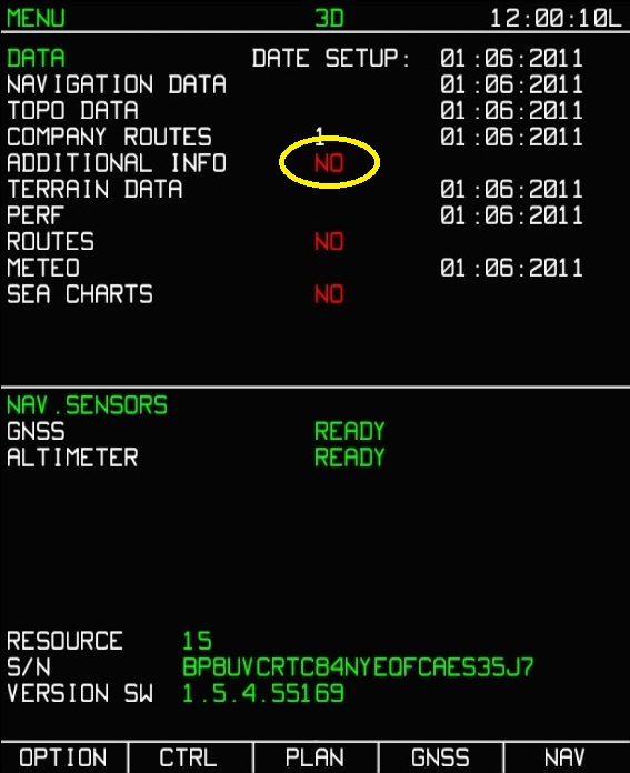
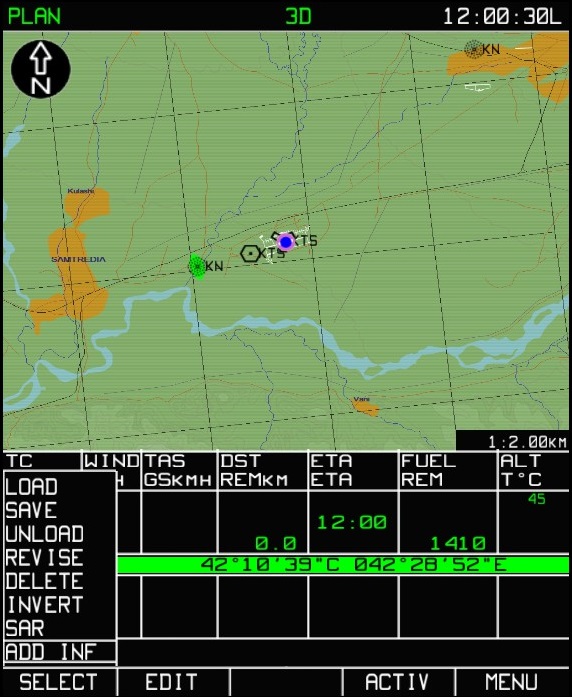
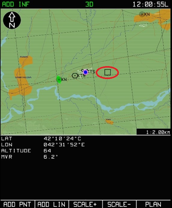
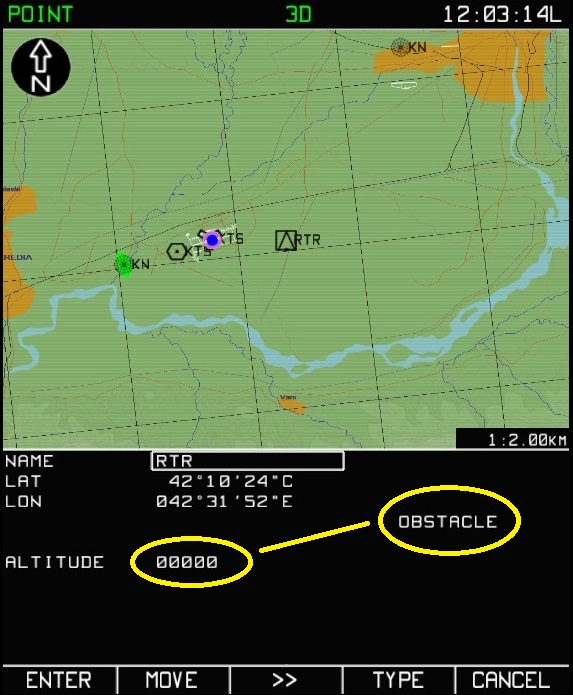
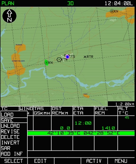
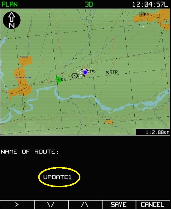
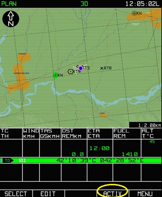
1)You will always find yourself starting on the "MENU" page. I have circled in yellow "Additional Info = NO". This tells you if you or the ground crew(Mission Editor) has saved any lines, points, etc into ABRIS. We haven't added anything yet, so it will say NO. To get us started we need to select "PLAN" (3rd Function Select Key, or FSK) 2)This will bring you to the "PLAN" page (ABRIS will tell you of which screen you're on in the top left corner of ABRIS). You will then select FSK 1 for "SELECT". This brings up a sub-menu, you can scroll thru this sub-menu with the ABRIS "Axis" rotary (Bottom right of ABRIS panel). The ABRIS Axis rotary is also a push type, this is basically a "Enter" button. Note I have scrolled to "ADD INF", and now we will push the ABRIS axis to select it. 3)Again note that the page we are on is named in the top left corner of the ABRIS screen. Once on this page, I have circled in red the "black box cursor" that will show up. This will appear directly over your aircraft initially, and I have slewed it away so it is visible. If it is already over a known point (airfield for example), you will not see the cursor. To slew the cursor around use your ABRIS axis, it will start by moving it left/right. You can change the axis to up/down by pressing the ABRIS axis enter. 4)Select FSK1 "ADD PNT", this will bring up a sub-menu. "DIRECTLY" is already highlited and this is what we want. So Press the ABRIS axis enter. 5)Here you will notice "TYPE" with a yellow circle with a line going to "REFPOINT" circled in yellow. There are 6 different "types" for you to choose from(VOR, AIRPORT, NDB, LANDMARK, OBSTACLE, and REFPOINT). VOR, AIRPORT, and NDB "icons" will be the same as any other listed on the map. LANDMARK and OBSTACLE icons will be a black triangle. And REFPOINT icons will be a black "X". You will also see a selection ">>" marked with a yellow circle pointed to coordinates and "RTR" marked with a yellow circle. The ">>" allows you to move thru these selections if you wish to change them. I have named the "CALLSIGN" RTR for RotoryWing. I generally use REFPOINT for when I have spotted an enemy aircraft position either myself or spotted by GCI or other friendly aircraft. I will explain how to input names in teh next screenshot. 6)You will notice the selection box is now around "RTR"(I have also changed the type to "LANDMARK"). In order to change names, have the box selected using the ">>" or FSK3. You can cycle thru each letter, punctuation, or number using your ABRIS axis rotary. Once you have selected the correct letter, press the ABRIS axis enter to move onto the next letter and so on. You are also able to input the exact coordinates of an object by going thru the same process for the Lat/Long coordinates. (Cont)
-
I thought I would add a thread because I have been getting all kinds of questions. Especially for examples of what I am doing in my cockpit before, during, and after an attack. Non of my information is "top-secret" and I am happy to help with anything I can when it comes to the Shark. Also if you have information that is valuable to other Shark pilots, feel free to add. The only thing I would say is keep it on topic, factual information, and NO talk about systems that aren't even implemented for the Ka50. I will try to add information as often as I can. More than likely ABRIS related because that is in my opinion the most valuable SA system you have at your disposal. I will add screenshots as well with explanations as requested by some other pilots. What I can say is that updating your ABRIS every few minutes, or when you recieve new information is key! With that being said lets talk about adding points of interest into your ABRIS. (Step 1-6 is below, because it didn't add the screenshots) 7)For adding an "OBSTACLE" you will notice you are able to add the "ALTITUDE" for the obstacle. Also changed with the explanation above. 8)On this screen shot you will notice we have added a "REFPOINT" named "RTR" circled in red. We must now "Activate" this change, press FSK4 "ACTIV". Note that nothing on the screen will change when you press "ACTIV", but ABRIS has input this point no worries. 9)We must now save this change into our ABRIS plan. So from the same page we activated this point, select FSK1 "SELECT". You will have a sub-menu appear, scroll using ABRIS axis to "SAVE" and press ABRIS axis enter. 10)Do not save a route until you have enetered all the points you want to add. But once you have enetered all your points, "SAVE" will bring you to this screen. I have named this plan or "ROUTE" as "UPDATE1", entereing the name is the same as I described earlier using the ABRIS axis to select each letter. Once you have entered the name you want, press FSK4 "SAVE" to save the changes to the database. You are able to have multiple plans or "ROUTES" in your database, and you can load or unload different ones (I will save this for a later date). 11)Once you have "SAVED" your changes you will come to this screen. You must activate this plan or "ROUTE" if you wish to use it. press FSK4 "ACTIV" to activate it as your current plan as circled in yellow. 12)Once you have activated your route, it will automatically bring you to the "NAV" or navigation page. You will notice our "REFPOINT" has been saved and is active in our route(marked by red circle). And, you're done! As I have mentioned in prior posts I can do this pretty quickly because I use Cougar MFDs as inputs for ABRIS. Practice this and soon you will be inputting points within a few seconds. Before having MFDs I used the key commands instead of hovering the mouse over the in-cockpit ABRIS. Was much faster in my opinion, but whatever works best for you. I also use multiple monitors and Helios, So I dont need to look at the in-cockpit ABRIS which is SOOO much easier and faster. Generally I can input a suspected enemy aircrafts position within 10 seconds. You don't need to input their exact loaction, just a general location to pay attention to. Anyway, I hope this helps for people that haven't thought of using this function of ABRIS or didnt know how. I tried to explain in as easy of terms as I could. The ABRIS is the most complicated yet most useful system we have at our disposal in the Shark. If you have any feedback that I wasn't clear enough in my explanations or I didn't explain in-depth enough, please let me know. Thank you for your time! Reaper6
-
Operation "Blue Flag" - 24/7 PvP Campaign - ROUND 8
Reaper6 replied to gregzagk's topic in Multiplayer
That's how we roll! Reaper6 -
From BS 1 to BS 2 odd behaviour in courier miz
Reaper6 replied to aairon's topic in DCS: Ka-50 Black Shark
Oh I thought it was the Jeep that hit me. But yeah there was a guy walking, he ripped off my radio antenna... What a strong little guy to turn the Shark like that lol. Reaper6 -
From BS 1 to BS 2 odd behaviour in courier miz
Reaper6 replied to aairon's topic in DCS: Ka-50 Black Shark
I just finished the mission. Are you talking about the truck that hits you right off the bat? Also, you are loaded with 2 wing fuel tanks. Dont forget to turn on your int wing fuel pumps. I had plenty of fuel for the mission, the external tanks will eventually start filling your internal tanks. Reaper6 -
Operation "Blue Flag" - 24/7 PvP Campaign - ROUND 8
Reaper6 replied to gregzagk's topic in Multiplayer
Just to add on my previous post... I am accepting applications for a steady KA50 wingman(No experience necessary) to practice for the next campaign(due to the increased number of targets at airfields). We can train together taking out airfields, FARPs, or whatever. Two trained pilots in KA50s working together would be awesome! Anyway, if anyone is interested that would be great. Also having a Mi8 as another wingman during our training would also be a good idea, so we are all on the same page. Reaper6 -
Operation "Blue Flag" - 24/7 PvP Campaign - ROUND 8
Reaper6 replied to gregzagk's topic in Multiplayer
Makes sense, I'm always up for a challenge. This is probably the only server I actual get a challenge, the other servers it's nothing for me to fly waypoint to waypoint and kill whatever is there. It seemed to be balanced a majority of the time based on skill level, team work, or whatever the case was regardless of the numbers. I think if numbers were really the big issue, we wouldn't have pushed Blue all the way back to Senaki. We lost focus and settled in for defense instead of pushing on for the attack. Whatever the case, you and your team are doing a fine job. Keep up the good work and making every campaign more and more of a challenge. Reaper6 -
Operation "Blue Flag" - 24/7 PvP Campaign - ROUND 8
Reaper6 replied to gregzagk's topic in Multiplayer
I agree, Red does have an advantage even when its 2 to1 in favor of Blue. I actually prefer those odds. 3 to 1 pretty much evens it out, but beyond that where you would see 40+ to 3 or 4 is unacceptable for either side IMO. I think now that they added more targets on airfields it will also be harder(at least for me in a KA50) to destroy an airfield on my own. Which I am totally in favor of, 1 person should not be able to bring down an airfield by their self. So I think that was a step in the right direction, even though it sucks for me. Reaper6 -
Operation "Blue Flag" - 24/7 PvP Campaign - ROUND 8
Reaper6 replied to gregzagk's topic in Multiplayer
I don't normally fly jets, actually I don't fly jets at all come to think of it. But I would say I am fine with heaters only or moving the Mirage to the Red side. If the purpose behind it was to even the numbers out a little, I would say it's worth a shot at least in testing. I think no matter what scenario BuddySpike comes up with, there are going to be people that aren't happy with it. So let's give it a try and, who knows! Also on a side note about team balance. I haven't done any mission scripting in a long long time. But perhaps there is a way to limit capturing objectives if there is a very large difference in numbers for either side. If Blue or Red is occupying 75% of the server slots, then they wont be able to capture anything? Or maybe that side is limited on weapons or aircraft? I don't think any of the changes they are making for the next round is necessarily a bad move. Why not try different things? That's pretty much what made BlueFlag so successful in the first place. No matter what there will be good and bad things on both sides. Imagine if the ground units were organic, Blue would be at a MASSIVE disadvantage! So I think we should all calm down, do the testing and see how it goes? Reaper6 -
A couple of questions about navigation
Reaper6 replied to CheshireCat's topic in DCS: Ka-50 Black Shark
You're welcome. I haven't played the courier mission in a long long time. You should be able to open the mission with mission editor and fix the guy running into you? I might have to try the mission out today, I think it was probably my favorite mission back in the day. Reaper6 -
Operation "Blue Flag" - 24/7 PvP Campaign - ROUND 8
Reaper6 replied to gregzagk's topic in Multiplayer
@Greg I flew on the server last night, and tested the FARPs to see if I can refuel(Red Side). The fuel trucks are there, but they are too far away from the actual FARP. If you can move the fuel truck to near the Urals are, it should work. They pretty much have to be sitting on the FARP itself like the Urals in order to work. Thank you. Reaper6 -
Operation "Blue Flag" - 24/7 PvP Campaign - ROUND 8
Reaper6 replied to gregzagk's topic in Multiplayer
Their dual 30mm cannons mixed with 8x 9M311 missiles would shred anything within its range. I personally hate going up against them, but I train attacking them constantly because they are the most dangerous for any CAS platform. Reaper6 -
Operation "Blue Flag" - 24/7 PvP Campaign - ROUND 8
Reaper6 replied to gregzagk's topic in Multiplayer
Apparently you've never met a Tunguska! Thank God they aren't in BF. Reaper6 -
Operation "Blue Flag" - 24/7 PvP Campaign - ROUND 8
Reaper6 replied to gregzagk's topic in Multiplayer
I'm all for that suggestion, no missiles for any fixed wing planes guns only :) Reaper6 -
Operation "Blue Flag" - 24/7 PvP Campaign - ROUND 8
Reaper6 replied to gregzagk's topic in Multiplayer
Guys let's calm down a little lol. I'm sure they are still planning for the future round, and testing. All that really matters is that now I will be able to refuel when I kill everyone at a Bluefor FARP :) Reaper6 -
Operation "Blue Flag" - 24/7 PvP Campaign - ROUND 8
Reaper6 replied to gregzagk's topic in Multiplayer
Wow, that's a heck of a deal! I know the US Army operates its one and only Mi24 HinD 6 miles from me at Ft Polk. Not sure if they still have it flying around, but was cool to see when I was training there. Reaper6 -
Operation "Blue Flag" - 24/7 PvP Campaign - ROUND 8
Reaper6 replied to gregzagk's topic in Multiplayer
I actually liked the Mirage on Blue side, it seems to run on coal with the amount of smoke it pours out. Very easily spotted! Just a side note, Germany also has a squadron of MiG-29s doesn't it? I believe they were left behind after the collapse of the USSR? Reaper6 -
A couple of questions about navigation
Reaper6 replied to CheshireCat's topic in DCS: Ka-50 Black Shark
The only time you would need to calibrate the ABRIS GPS would be if some of your systems were damaged, and you returned to base for repair. Sometimes you will notice after repair your helicopter icon in ABRIS is floating around randomly. It will usually correct itself after a minute or two, or you can manually calibrate it. This would be the only instance I know of that you would need this. there are also two "test" functions you can perform thru ABRIS, without going into to much detail but basically to "remove" a disruptive satellite from ABRIS. Both NAVSTAR and GLONASS can and are used by the ABRIS. Generally during wartime, NAVSTAR is encrypted in the area of operation to prevent the enemy from use. In ABRIS GLONASS satellites are represented by a "square" symbol, and NAVSTAR by a "circle" symbol. Sometimes you will also have certain "failures" in ABRIS due to Satellites or the ABRIS itself. But that is like a 3 hour discussion of each failure and how to fix each one, remove a satellite, RAIM Thresholds, etc... How much stuff is actually implemented in ABRIS is mind boggling to be honest. DCS definitely went above and beyond when they implemented all the functions of the ABRIS. Also just to note again, the ABRIS never was and is not exclusive to the KA50 and was used in civilian and other aircraft. Reaper6 -
Operation "Blue Flag" - 24/7 PvP Campaign - ROUND 8
Reaper6 replied to gregzagk's topic in Multiplayer
Oooooooh Blue is in trouble now that I can refuel at FARPS! Reaper6 -
Operation "Blue Flag" - 24/7 PvP Campaign - ROUND 8
Reaper6 replied to gregzagk's topic in Multiplayer
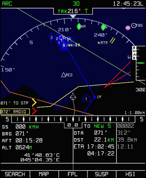
I tried to get a general screenshot of my ABRIS prior to making an attack. I will try to describe what I put and hopefully it will help. Red lines- I use these lines for vectors of possible enemy aircraft. I draw them from enemy airbases but not FARPS. So I know I will be paying attention to this area during my attack for fast movers. Green Lines - I use for vectors of possible enemy chopper routes, not necessairly from enemy FARPs. But from routes I would consider taking myself if I was a enemy Heli. Orange lines - Usually I have a transport Heli (or 2)in tow, so this is the line he will not cross until all air defenses are taken out. Yellow lines - This line I use as a guide mainly. I engage around 10-30m from the ground, not more than 50m So this line is for me to know a safe distance from the target, at 50m AGL without being in radar coverage. Triangle - I use this as a alternate firing position. If I can't engage a target from where I am at less than 50m, I will move there and engage. X - I use for last known enemy aircraft position. RTR- Rotory wing, JET - Fixed wing(if I have time I will instead put A10, F15, etc). The house labeled "1" is your Ingress point, from where you will launch your attack. When I am at the waypoint before my IP, I will scan that area and find a building, house whatever I can hide behind. Lock the object in the Shkval and make it your IP. From there you can select that point, and press Ingress to Target. This will give you distance in the bottom of your HUD, and makes for better situational awareness. Where you mark your attack waypoint on the ABRIS map, may not be the best attack position, so that is why I use this. While moving into the target area scan for all targets, and mark them accordingly in the Datalink. I generally make the "house type" which is Air Defense, my most lethal of the targets, EWR, Tunguska, etc. The "Diamond type" which is Armor, I will use for AAA, or less lethal SAMs. The "box type" which is for Other, I use for targets that are easily killed with guns or rockets. There have been situations where I have used all 3 types for all the Air Defenses because there is so many. It's very easy when you cycle thru all your datalink targets to just kill one right after the other. Erasing them off your ABRIS as you go, so you dont get confised what you have killed and what you havent. You can select "Ingress to Target" and press uncage Shkval and your Shkval will slew directly at that target. You may also notice on the Right side of the ABRIS in the middle there is BHAB. This is for your planned altitude, USE THIS! input this along with your waypoints, VNAV is also useful. You will notice the two green lines are lined up in the middle of the graph, this is what you want around 50m AGL. If you are higher than that, you are too high! Anyway, hope this helps a little for the KA50 pilots. This is just some random mission I used not a "Blue Flag" mission. My ABRIS in BF is nearly covered by the end of the attack. I generally use the ARC page instead of the MAP page because the lines are more visible and not confused with MAP lines. Easy enough to switch between the two. Also Keep in mind I am using Cougar MFDs to navigate ABRIS. So using your mouse and clicking buttons etc will probablly take longer than it takes me. Reaper6