raus
-
Posts
218 -
Joined
-
Last visited
Content Type
Profiles
Forums
Events
Everything posted by raus
-

2.7 OB Crashes recurrently (after fresh reinstall also) in VR
raus replied to raus's topic in Game Crash
Ok… that seems to be the one pre-reinstallation. I will give it a try, anyway, this afternoon. Both power connectors of the GPU come from same cable, so might be worth connecting them to different PSU outputs. The PSU is a Chieftec GPS-1000C, not great, but should be enough (1000W). Will look into the CPU, although the OC it has is pretty safe and never gave any problems, and the GPU was running standard timing. will update later, thanks for the analysis and suggestions! -
Hi all, I will shout out here, as this is getting pretty frustrating... Since last week, I have been having crashes and DCS hanging up on mission load. System is as follows: - Processor: i7 9700K - GPU: Asus RTX2080Ti - RAM: 64GB Vengeance LPX 3200 - HDD: Samsung Evo 970 Plus 1TB - Headset: HP Reverb G2 As previously everything was running smoothly, I thought it could be due to one of the following updates happening in this timeframe: - Voiceattack - VAICOM plugin - Openbeta 2.7.2.8165.2 The issue was that I was getting DCS hung on mission load relatively often (would stop at navgraph stage, beginning of the progress bar), or just DCS crashing in the middle of a flight 1.- I disabled all the mods, and reinstalled Voiceattack and VAICOM, and run a "slow" repair of DCS, but the behavior continues... 2.- Then, I decided to be drastic and went for a complete reinstall of DCS, Voiceattack, Vaicom and SRS (just in case, but was not active in the tests) In attachment, one log from the old install, corresponding to a crash, and one right after finishing the fresh install, also from a crash. The problem seems to happen at C:\Program Files\Eagle Dynamics\DCS World OpenBeta\bin\edterrainGraphics41.dll but I don't know what else to try Just for info, the last crash (log from 25/06) happened in the Hornet Aerial Refuelling Mission, in the Gulf theatre, shortly after having plugged into the S-3 basket dcs.log-20210624-213904.zip dcs.log-20210625-213318.zip
-
Well, last time I tried, all the mentioned things were missing. Specially, no cues on hud, and bombs would not release, when trying to loft them, or even drop level… I have not tried again, as I got the responses above about the incomplete implementation, and they were matching my experience, but I did not see it mentioned in any changelog, so assuming it is still the same
-
Is that really happening in a „buggy“ way? I mean, it has happened to me once or twice, but always assumed the bandit was turning jammer on, and therefore the 99.9 reading…
-
Version 1.3.3 just released!! ...fixing some annoying bugs and catching a couple more exceptions. Full changelog available theough the update dialog in the app. as always, feel free to share your feedback and/or suggestions!!!
-
Version 1.3.2 is out! See the complete changelog in the update dialog. Mainly reworked the coordination ard, as it was not very intuitive. Also stretched some fields to display both UHF/VHF frequencies for airfields, and modified the commcard to accomodate additional airfields, so that multiple flights can share a common commcard.
-
Hi @Fisherman82 you don‘t really need. You can download the version linked and update, through the app itself, to the latest version. i am packing a new update that will be released through the app, at the moment
-
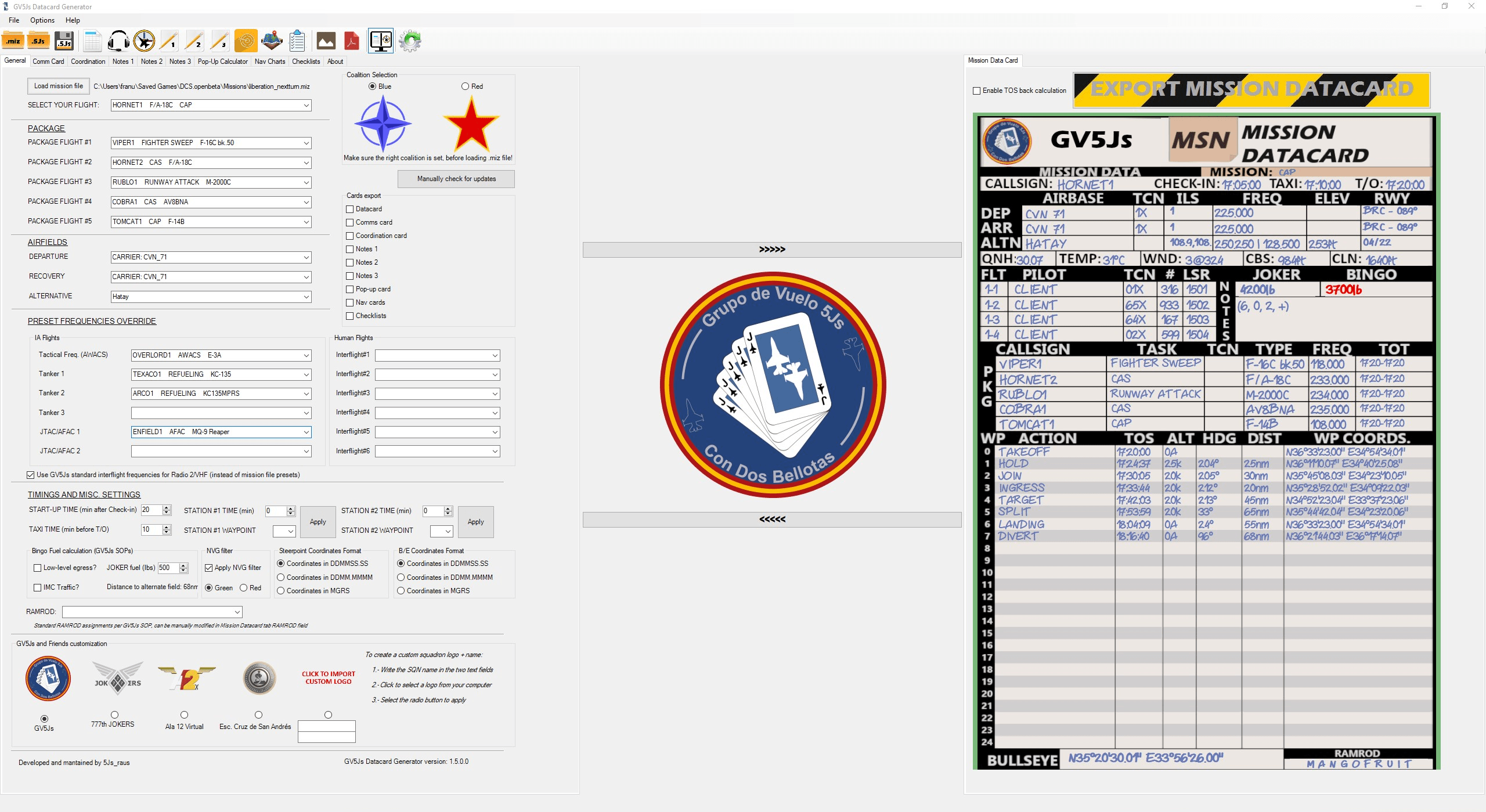
New version available. Hopefully, a good overhaul: v1.3.0 Changelog: Fixed a bug in the UHF/VHF frequency selector for airfields Manual selection of PUSH - EGRESS waypoints to calculate VUL Time / TOT For self (selected) flight, in the Mission datacard, use right mouse button click on WP Name and "Select WP type" For other flights, use the "Edit WPs flight#" button on the coordination card and use right mouse click on the window that pops up Changed the Mission field on top of the datacard to display own flight task instead of sortie name Introduced length checks in WP names, Airfield names and Airfield ILS fields (orange + message box if there is risk of overlapping) Increased font size for the Bullseye coordinates In Notes cards, the red button pops a color picker dialog, to select font color, rather than only red/blue In Mission Datacard, replaced the buttons to set WP as TGT with the context menu (right click) on the WP Name --> "Send Coords to Notes#1"
-
I could offer a couple different styles for the template. Just that all the fields, including logos, will fall in the same positions. Sure, it takes a little time, though, because for the editor to look ok, I would also have to make it so that when you change the template, all the editable text fields change their background color, to match the new template, so it does not look weird. If I make it so that each user can load their template, there are two drawbacks: first, you would have to create a template for each page and second, I have no way of knowing which color scheme you use, so the text fields in the app would keep their current background, and look off.
-
Hi @Wrench, Well, the main idea of the app was to export PNG images, to use as kneeboard, specially because a lot of the people I fly with, as well as myself, are flying in VR exclusively. I wanted everything to have the same look & feel, and that is why I created templates that kept the style from the checklists I also started creating over the original work of @BatLunette. That being said, I am currently saving kind of a csv file (not exactly that) encoded in the .5js file, for distribution and reworking of the datacards. However, for making a proper csv export, some rules should be observed, as if we are going to do it line by line of the datacard/commcard (one separator for fields within the same line, and a different one to separate lines). Also, this would be easy to implement for the mission datacard and the commcard, but the coordination card, pop-up profile, notes... are relying in some images to display the info. So, what would you have in mind? I mean, how would you like to use the program, and what export do you need? I can have a look at it, but I cannot promise anything, as the backlog is still full with tasks to improve the current status. Changing the background profile would not really be an option as of today: the GUI is hardcoded to place text fields in specific locations, so that we have a manually editable version before exporting, and the export itself places the text aligned to the template, so you would need a template with the same layout of fields as we have now... PS: if it is a matter of customization, just remember that you have the option to include your squadron logo, and name (up to two lines), and it will replace the GV5Js logo on every page
-
Hi @maxxstv, I am afraid the font is hard-coded at the moment. I just customized it for the app, and the alignment of the exported images is calculated with that font in mind. When using other fonts during the development, the alignment points were different so, if I allowed to select different fonts for the exports now, they would probably end printing the text all over the place and not inside the fields of the template. However, I do not discard having a second look at it in the future, once I've finished with the backlog of features currently being worked on regards
-
Ok, got it. Did not test the .miz, as that links requires adding some extension to the browser to download, but the problem is that I had not included any chart for Jean airport in the bundle. I have check that the chart exists before trying to export, will add the comprobation quickly. Meanwhile, I would avoid trying to export charts not included with DCS or in CombatWombat's packages
-
Version 1.2.1 is out!! It fixes (I hope) the issue reported when loading some missions, and polishes functionality of the coordination card. Full changelog available via the in-app update dialog. @Kariyann71 the issue you reported should be fixed now, please feel free to check and report if you still experience any weird behavior @Shrike88 of course. I missed WDP functionality, and this is how all started. I think we still miss some of the ecosystem that was created around BMS during the years, but the gap is being closed steadily. If this app helps in that effort, or if it is just useful for someone, I am glad.
-
It is fixed, I will bundle it with a couple other modifications and release it tomorrow. It is a weird case: I was relying on carrier TCN and frequency for some checks, and the tarawa in that .miz is lacking both
-
Thanks!! I will have a look with that .miz Hopefully it will be quick to find and fix, and then I can release a fix tonight/tomorrow
-
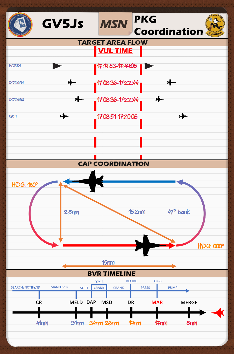
Version 1.2.0 available via update through the app itself. v1.2.0 Changelog: Added the ability to detect the TOT/VUL Time window of package flights Time calculated between "PUSH/WPT2" and "EGRESS/DP" (second option to accomodate F-14 WPs Checkboxes added on General Tab, to extrapolate own flight delays to other package flights (only Client Player flights): Start-up delay Station Time #1 (AAR/HOLD/CAP...) Station Time #2 (AAR/HOLD/CAP...) Now, tankers in Comm Card will also show TACAN channel, in addition to name Fixed an error when loading a second flight to be edited, and the "GV5Js standard frequencies" checkbox was ticked Added a Package Coordination Card Target Area Flow CAP/HOLD pattern coordination BVR Timeline Re-worked tabulation order in Mission Datacard page, to allow fast navigation through fields Caught and fixed an unhandled exception when there were non-carrier ships in the mission Fixed a random error when loading .5js files

-
Hi!! actually I have already caught a couple of these exceptions. In the next version (due tonight CET, or tomorrow) they are fixed. I remember one with the comboboxes index, if there were non-carrier ships in the mission. Regarding the pdf generation, I could not reproduce it, though. If you could upload your .miz somewhere, I can have a look and have a better chance to debug those exceptions. I try to systematically address them, but it always seems to be something I overlooked. cheers
-
Which background picture you mean? In the app, or in the generated cards? Point me to it, please... I will have a look for the next update. Ideally, I'd like to keep some "branding" representing where was the tool originated from, but I might add some more customization options, of course. Just let me know or, even better, post an edited picture, so I know what you are thinking, and I might give it a try
-
As far as I know, it can be used with any plane, and we usually do (F/A-18, F-16, F-14 regularly). I imagine the 2 radios / 20 channels each might not be enough for some plan, though... However, I am not sure what do you have in mind when asking A-10C. I mean, is there anything specific not suiting? Regarding the logos, I just hardcoded those from my squadron and those which usually fly with us, but left an option to add a custom logo + squadron name for the rest, let me know if it is unclear how to use it BR
-
Datacard Generator update available (1.1.23). Support for up to 25 Steerpoints added MGRS support has been added as per@Stingray 1-1 Mongo suggestion. Thanks!! Formatting options for text in notes
-
I still need to investigate MGRS... but I definitely do not discard it
-
Well, I have just made an additional test, so here are the results: PP mode: Entered the coordinates, set Auto-loft to 30° Approaching the target in NOE flight, then pull-up to 30°, 5nm from the target... bombs do not release Level flight at 20k, wait for the release mark, with pickle held 5-10 seconds before the mark crosses FPM... bombs do not release Changed to TOO, found the very same target with the TPOD, and designated it, keeping all other info (Auto-loft 30°), fly level and... bombs did release!! Weird... (edit: grammar)
-
Hi! I've found some confusing info cross-checking posts and YT videos... So far, I can see the symbology for the Auto Loft delivery working (except for missing pull-up cues). But when I try it, bombs are not released, regardless of me climbing with the set angle (15-30-45°), holding pickle button before the release mark crosses the FPM... If I switch to Manual, bombs release as always. I have seen a couple videos where this mode seems to be working (one lofting, one from Wags on level flight), but I am not sure if I am missing something... Thanks!!
-
Hi! I just wanted to share the experiment I started some time ago, to have a small app creating PNG images with the flightplan filled in, to use as kneeboard in VR. With some time, and the help and encouragement of my virtual squadron mates, and some users here, this has grown from a small experiment into something that is useful (at least, I hope so), so I thought it would be worth sharing. Currently, in version 1.5.0, the features are (quick summary, not updated in a long time, so some features could habe been missed in the re-cap): Mission importing from .miz file Selection between Blue/Red coalition Green/Red NVG filter applicable to all pages Export formats: individual PNG files, ZIP file with all PNG images, PDF file Possibility to select individual pages to export Standalone format (.5js) to save status/distribute the cards, and continue edition Option to add a startup delay to all waypoints TOS (for Cold start) and up to two station times (AAR, CAP, HOLD...) Mission Datacard Mission timing: check-in, taxi, takeoff (delays adjustable) Display of info from up to 5 flights (Package section): Callsign, Task, Tacan, Aircraft type, Frequency and TOT (manually filled) Departure/Recovery/Alternate airfield info: populated from flight plan, but editable. Name TCN, ILS, Freq (UHF/VHF selectable), Elevation and Runway heading (BRC if carrier) Weather data: QFE, temperature, Wind, cloud base, cloud ceiling Flight info: pilot name, tacan(manual edit), BORT number, laser code (manual edit) Joker and bingo calculation Waypoints: action/name, altitude, heading, distance, coordinates, TOS Right click a waypoint to send its coordinates to the notes1 tab Coordinates can be changed between DDMMSS.SS, DDMM.MMM and MGRS Grid Manually modify the TOS of any waypoint, with the option to re-calculate timing before that point Support package, for the comm card: AWACS Up to 3 tankers Up to 2 JTAC/AFAC Commcard Support of 2 radios with 20 preset channels Posibility to overwrite .miz file with presets Codewords: GV5Js standard, but possible to edit manually Pop-up calculator Left/Right action graphics with all parameters Notes Notes 1: text + image layout (option to send TGT Coordinates from Mission Datacard to Notes1, with mouse right click) Default image: AMSL authentication. Can be changed clicking on it Notes 2: Full page image Notes 3: 2 images layout Navcharts DCS and Combat Wombat's charts for Caucasus, Nevada, Persian Gulf and Syria Checklists F/A-18C checklists F-16 Cold Start and Mavericks A-10C Cold Start F-14 Pilot & RIO Cold Start Program notifies of updates available Initial installation file in provided link Updates through the app Coordination Card 1 or 2 CAP Patterns Option to include a TGT Area Flow graph, defining timing for each flight in the package Selection between PUSH/TOT or VUL time per each flight BVR Timeline for main A-A threats Added 2-panel layout option, to visualize 2 tabs (can be dragged) at the same time Download v1.8.6 PS: if you want to contribute to the development, there is a paypal button to accept a beer
- 192 replies
-
- 23
-

-

-
Now that everybody is back to work... Wouldn't it be great if we could have some "official" clarification? Please...