Bremspropeller
-
Posts
2107 -
Joined
-
Last visited
Content Type
Profiles
Forums
Events
Everything posted by Bremspropeller
-
The one where it was determined that there's gonna be a need of two additional access doors for GM1 installation (as well as a reconfiguration of the oxy-bottles, which you seem to not care about), which you claim were in all 190A-8s and which halted delivery for two months. Report dated 4.4.44, first loss 8.4.44 R4: "Entered service 12.44" - so after which the designation was supposedly dropped?
-
That explains why the first known A-8 losses on the front in the west were a full four days after the date of the report.
-
Strawman. We're here 'cause you're claiming an A-8 with a TS motor was initially designated R4, which so far you've failed to prove.
-
It is. The translation is not correct. See above. "Mit Anlauf der vollständigen TS/TH Triebwerke wird die bisherige Serienbezeichnung Fw 190A-8 geändert und erhält die Bezeichnung Fw 190A-9." With the beginning of serial production of complete TS/TH engines [TH never was built in serial production], the designation will be changed from A-8 into A-9. This is a remark to the fact that the TU motor was a combination of D and TH components, which the TS wasn't. "Anlauf" designates the beginning of serial production. There's no reference of an engine swap at all. "Anbau" / "Einbau" would make sense in that regard, but not "Anlauf". By the time of the report, factory-built A-9s were already in service. Production started in September '44 (Fw @ Cottbus, mostly R11s). The A-9 designation for TS powered aircraft was already in place by August. Mimetall at Erfurt supposedly built A-9s starting in August 44 (!), which does not make sense and they were most probably a mix-up. Other sources (acc Rodeike) identify those as A-8s. Externally, the A-8 and A-9 would look very similar, depending on the motor (e.g. TU in the A-8) and canopies fitted.
-
So you're claiming that two months after the start of serial production at two different factories, Fw people (!), BMW people and AGO people meet up at a third place to identify the need for those exact access panels already there. http://www.wwiiaircraftperformance.org/fw190/Fw_190_A-8_Besprechungs-Niederschrift_4-4-44.pdf Got any comments on the required changes to the oxy-tank arrangement (like in the Ta 152) as well? Btw this part: Is completely made up by you. Really? Where? It says that the D and TU motors are interchangeable and that with the start of production of the TS/TH motors (TH never happened) that aircraft will be called A-9. There's not a single word on exchanging or swapping the motors (TS) in the field, which you're implying. The A-9 was a thing since early '44. At first projected with the F motor and later with TH delays, earmarked for the TS. In August. No R4 designation. Except that it never mentions motor-swaps. "Anlauf" means "start of serial production".
-
A-8 serial production started in February '44 at Focke-Wulf Cottbus and Fieseler (Kassel), so two months later, delegates from Fw and BMW meet at AGO to conclude they'll need access panels that have already been there. Makes sense. Well, we do have factual proof of US airplanes actual firing rockets for starters. Quite the opposite of any fully-fledged and operational GM1 system in combat on a 190A-8. Nope. Fw Entwicklungsmitteilung 3 August 44 already stated the TS engine to be used for the A-9. Thats almost four months before Baubeschreibung 284 (late November 44) and just about after the GM1 device was cancelled from the specs for both the A-8 and A-9. No mention of your "R4" in association with the A-9 in that report.
-
Not According to AGO, BMW and Fw. See report. Two new access panels were required and the oxygen tanks were to be fitted differently (iaw Ta 152 design). Those designs were to be introduced into AGO serial production with the yet to be awarded contract. You're turning in circles. A motor with nozzles in place, yet no piping and no tank cannot provide GM1 injection. That's not an internet argument. That's common sense And without the tank and piping, there's no NOS.
-
No, it's not. You're basing your point on "it could be done". I'm basing my point on "there's no evidence for the use of GM1". None. Your "proof" furthermore specifies there's no spec for the GM1 tank ("nicht gefordert" doesn't translate into "not normally done") in the A-8. Meaning there's no Rüstsatz that covers GM1 installation and any deviation would be a field mod, as the R4 had been cancelled. No tank means no GM1. No mention of GM1 use for II/JG 301 in the JG301/302 unit History or with Jochen Priesn's "Jagdfliegerverbände". The GM1 injection-nozzles are there, but the whole upstream-affair (plumbing, piping, tank) is to be fitted by the airframer. You - again, conveniently - cut that away. The only airframer earmarked for production was AGO for 200 airframes (some modifications were required, see report below). The R4 spec was cancelled, however. http://www.wwiiaircraftperformance.org/fw190/Fw_190_A-8_Besprechungs-Niederschrift_4-4-44.pdf Some (eleven known in total acc. Rodeike) R4s supposedly at 10./JG11 in winter 44/45, but no mention of GM1 there either. Neither in Prien's JG1/JG11 unit history, nor in Jagdfliegerverbände. AGO WNr. blocks with known "R4s" are: 732 001 - 732 310 (built August '44) 733 670 - 733 790 (built September '44) 733 960 - 733 999 (same) 734 350 - 734 400 (same) 738 100 - 738 400 (built October '44) The GM1 requirement had been dropped by late July 1944. Most likely as Erhöhte Notleistung had been put into serial production (June 44) and field-modifications. As acc. Rodeike many of those WNrs were built to R2 or R6 specs, there is a possibility of mix-ups or typos in unit-docs. It had the nozzles in place. You conclude acc. the report it had no tank, I conclude they're not specifying which tank was installed. As they're not mentioning any difference to the common A-8 (see "later intelligence" portion), it's highly likely it had a standard 115l tank. The wrong tank for NOS'ing. No. They concluded it had "provisions".
-
Nope. No GM1 tank fitted. Double nope. See above.
-
Thankfully wwiiaircraftperformance is back online! http://www.wwiiaircraftperformance.org/fw190/td284.pdf Blatt 2: "[...] Zur Zeit ist jedoch für die Großserie der Fw 190A-8 nur der Einbau des zusätzlichen Kraftstoffbehälters eingeplant." Blatt 3: "[...] Der Einbau einer GM1-Anlage anstelle des Zusatzbehälters im Rumpf ist grundsätzlich möglich, jedoch für die Baureihe Fw 190A-8 nicht gefordert. Der Einsatz erfolgt in Höhen ab 8km und ergibt einen Geschwindigkeitsgewinn von ~58km/h bei Steig- u. Kampfleistung." No mention of GM1 equipment for Rüstsatz 11 (Blatt 4).
-
Same thing for me. Playing around with the brightness knobs belowthe HUD doesn't help either.
-
Thanks! Same thing (no mention of GM1) to note on this performance table from 10 June 44: Note: GM1 is also not noted for the Ta 152H, however. As it already had a two stage three speed supercharger with intercooling, the additional value of GM1 under normal circumstances is questionable anyway. Unless the mission is going to go really high. The range table I mentioned earlier (dated 15 March 45) in contrast mentions GM1 in it's fuel tank tabulation for the Ta 152.
-
Good ole TH motor - by mid '44 it was projected for a (delayed) serial production in May '45. Never materialized. By that time, Anton production was already ramping down and only Doras and Ta 152s were going to be built from mid '45 (June ~ July) onwards. Range and performance tables of Focke-Wulf (one I have is dated 15 March 45) never mention MW50 or GM1 for the 190A, while mentioning Erhöhte Notleistung for the Anton, MW50 for the Dora and GM1 and MW50 for the Ta 152C and H. BMW - Langenhagen Drift: Did BMW ever go to Langenhagen to do the integration of the GM1 second stage into the TH? When was the date of the report-excerpt you cherry-picked and at which time was the intergation performed and considered done?
-
Erhöhte Notleistung arrived on the front some time in July '44 by both field mod kits and new built aircraft. What was cleared when by whom is pointless when it wasn't used in the field (GM1). I won't repeat myself again. Have fun arguing with yourself.
-
No. No pod available.
-
So, you're agreeing with me that GM1 wasn't operational in Fw 190As. I'm focussing on GM1 because people are requesting it (same as MW50), while it was never used, as it (unlike MW50) quite blatantly sucked in handling. You had to know before starting the motor if you were going to need the additional boost above critical altitude or not, which quite obviously is a BS system. It also couldn't be stored for very long, so logistics - especially on dispersed airfields - was a nightmare. Erhöhte Notleistung made way more sense, as is was simpler and worked across all altitudes. It was available in about mid July '44 and the kit-installation could be identified by a small yellow ring fwd of the left triangular windscreen. There were other, obvious and relatively simple solutions the RLM messed up: 1) External supercharger inlets. A 15-minute sheet metal job, providing ~700m more critial altitude. 2) Sitting on their hands concerning Jumo 213 development in 1942, leaving the Luftwaffe without a proper counter to the P-51 for the better part of a year. 3) Not being able to call a winner in the whole Jumo 213 vs DB 603 affair (let alone the infighting with Mtt and their raggedy-a$$ aircraft). This alone cost another significant amount of time in high altitude Fw 190 development. 4) Wasting time in development of the 190B up to a fieldable aircraft (with GM1), but stopping just before it was ready. Do you need even more examples of RLM dropping the ball in program steering, aircraft development and procurement? You think that pragmatic solutions were going to be easy? Seems to me you have yet to meet proper german bureaucracy - let alone one mixed with a nepotistic centralized planned economy. You're sticking to semantics on one behalf, while assuming stuff on the other. The Einbauvorschrift above states the injection nozzles of GM1 and possibly MW50 (poor wording) being in place. It also mentions that appliances and the actual implementation of the systems are to be carried out by the airframer. It then gives a couple of instructions about the routing of the associated lines. It does not say there was an operational GM1-system "coming with the motor", besides the injection nozzles being in place. So were the MW50 nozzles apparently. What's more interesting in that regard is that both systems can't be built into the same airframe at the same time, as they'd need different tanks, taking up the same space inside the fuselage. GM1 would need the 85l tank, MW50 using the 115l tank (see MW50 installation on the Dora). It shows that BMW was providing Fw and the RLM with a motor that could use either system, but ended up with Erhöhte Notleistung in the field. Focke-Wulf Entwicklungsmitteilung from 3 August 44 states that the TU motors had been delivered fom "circa June". It's got the same power output as the D-2 (including Erhöhte Notleistung), being 60kg heavier. No mention of a GM1 system. Looks like "provisions" of the RAE actually means nozzles only. Again, what are you trying to prove? You're arguing GM1 was available/ cleared/ operational. Without a tank (which is not actually stated in the report), it factually is incapable of GM1'ing. The report states "Provision for GM1 power boosting installation, the routing for the GM1 tank being in the position previously occupied by the FuG 16." Farther down, it's stating it (obviously) was equipped with Erhöhte Notleistung. There is no differentiation between the 115l tank and the 85l tank - the latter of which would be required for an operating GM1 system. The former one being a stock installation in the A-8. What's the story of the 190A-5 GM1 wing installation you showed earlier out of that Beladeplan dated 3 November 42? It hints at an outboard wing installation, replacing the MG/FF. A similar wing installation IIRC was tested in the 190B initially, but it never came to fruition in either way.
-
The big picture is Fw tested GM1 several times, and with the A-8/R4 had aircraft production blocks reserved at AGO for 200 airframes with GM1 equipment installed. This never materialized. If the airframes were built with the GM1 equipment in place isn't clear (it's likely, though). There's no evidence for GM1 use in the field by Fw 190A squadrons. At the time of the Bengelmann visit, GM1 had already been projected and cancelled for the A-6 and the experimental (and ultimately cancelled) 190B was in testing. Just because Rechlin or the FAA aprove a modification, this doesn't mean the kit or serial installation is commercially available for procurement and implementation. A gap of several months is more than reasonable, even today. Certainly, but not only does the report not mention what exactly it means by "provisions" and "tank". It also fails to identify the components of that provision and it's difference to normal vanilla A-8 equipment. Further down, there's no differentiation between the 115l tank and the tank found in the crashed aircraft. That's precisely the reason why it wasn't popular at front line units. Especially during summertime. It's not a reasonable solution for operational use and it seems Galland himself didn't think much of it. The report is signed 1 October 44. 1 May 44 is the date of the design to be replaced. By that time, the "Erhöhte Notleistung" rating discussed is most probably 1.8 ata.
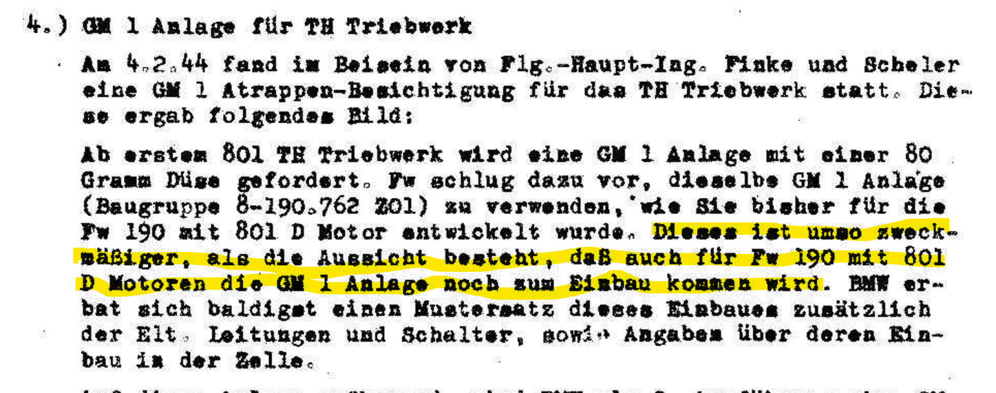
-
There is no physical evidence. The report mentions "provisions for GM1", but doesn't specify which tank was installed "instead of the FuG 16" - the 115l Zusatzbehälter or the 85l GM1 tank. Negative. The R11 Rüstsatz did not include GM1, but it did include some more advanced IFR equipment. RLM projected a run of 200 airframes, supposed to be built by AGO under the designation A-8/R4. GM1 was later cancelled by RLM for the use on the 190, though, as performance with GM1 was less than the 109's performence with the DB605D without GM1. GM1 was cancelled altogether by August '44 due to lack of necessity. Acc Rodeike only a few R4s supposedly are known to have been flying with 10./JG 11 around the op Bodenplatte timeframe. GM1 wasn't, as clearly stated in your travel-report Bengelmann: "Dieses ist um so zweckmäßiger, als die Aussicht besteht, daß auch für Fw 190 mit 801D Motoren die GM1 Anlage noch zum Einbau kommen wird." So on 04 FEB '44 a mock up of the 801TH GM1 device was shown, which would have an 80g/s nozzle, according to required specs. Fw proposed the use of the same device which was already designed for the 801D, as this design was prospectively to be used in the future. See above how this worked out. Approval by Rechlin or an OEM's test-bench doesn't include kits ready for shipment and modifications starting at the front units or even serial production in all branched-out factories. As we can see, GM1 was earmarked for some 200 AGO airframes only. Final approval by RLM is a different matter altogether. That's because you're busy reading things into stuff that's not written there. It's not "we're checking into it", but "the following solutions can be offered on short'ish notice". Seems you're not understanding we're dealing with a centralized planned economy here, where changes aren't just incorporated because some test or general approval make it seem favorable. Changes are incorporated into specificly ordered blocks, which at times may not happen for several months.

-
The document linked before proves otherwise. Again, no mention of GM1 use in frontline service, except maybe for special Mosquito hunter units (which might even have been 109s - can't be bothered to check atm). Native speaker here. No need for grasping straws on your end.
-
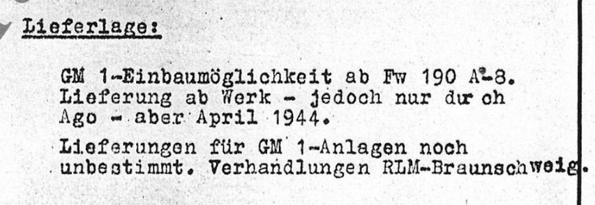
It doesn't. "In Kürze greifbare Möglichkeiten" means "shortly available/feasible possibilities (solutions)". Greifbar implies a possibility, not a given and already available capability. Further down in the same report, dated 15 March 1944: "Shipping-/ Supply-situation: GM1 equippability starting with Fw 190A-8. Supply from manufacturer - however by AGO only - in April 1944. Shipping/ Supply of GM1-devices still unsure*. Negotiations RLM-Braunschweig." It hints at the possibility of equipping GM1 from the manufacturer (as long as it's AGO) with projected availability in April '44, if GM1-device supply can be assured. I haven't seen any actual proof of GM1 or MW50 use in operations with 190As - maybe excluding the Mossie hunter units. *probably relating to OEM-allocation for GM1-devices.
-

Mobile starter Air for F-5 ops from FARPS
Bremspropeller replied to Bremspropeller's topic in Wish List
It doesn't, unfortunately. It's tied to not having a fitting vehilce. Including the available GPUs -
Bump. The following airbases are sort of essential (GAF): - Neuburg - JG 74 - (F-104G, F-4F, Eurofighter) - Manching - AG 51 and later WTD 61 - (RF-104G, Tornado, F-4F, Eurofighter) - Fürstenfeldbruck (Fürsty) - WS 50 and later JaboG 49 - (G.91R, Alpha Jet) - Erding - WS 50 and later AG 53 and AG 54 (G.91R) - Landsberg - LTG 61 - (Transall) - Lechfeld - JaboG 32 - (F-104G, Tornado) - Memmingen - JaboG 34 - (F-104G, Tornado) - Leipheim - LeKG 44 / JaboG 44 - (G.91R, Alpha Jet) Landsberg and Fürsty also had the FFS A and B (Fouga Magister and T-33 respectively).
- 36 replies
-
- 10
-

-
+1 Including more AIM-9 options, four AIM-9 launchers and Maverick integration.
-
So I tried to start the F-5 on a roadbase the other day, only to find out there's no way to get starter air for this case on a FARP. Will this eventually be solved?
-
So that's what the song's about...