ajax
-
Posts
491 -
Joined
-
Last visited
-
Days Won
1
Content Type
Profiles
Forums
Events
Everything posted by ajax
-
I had the same error. I solved it by manually creating the necessary folders and copying the lua files into it.
-
AFAIK, the only way for that file to get in the mission is if a track file is used as a mission file. The mission editor does not store it.
-

resizing edited photos to the mission briefings?
ajax replied to pbpullman's topic in Mission Editor
Yep. Second this suggestion. -
Adding a button is the easy part. Trying to figure out what changes need to be made to the proper tables and actually making the changes are the hard part. FC2 and DCSW are too dissimilar to allow an FC2 mod to work in DCSW.
-
Demon, you're thinking of Blindspot's ME mod for FC2/BS1. I miss those features, too. In fact, I've been trying to teach myself Lua so that I can reproduce some of Blindspot's features in the DCSW ME. So far, I've successfully implemented the Hide All, Show All, and Toggle buttons in the Units List Panel. I don't plan to implement his trigger-logic extensions, but I would like to have the change coalition feature.
-
Try \ on the ground and ralt+\ in the air.
-
There are two entries in the mission file that deal with coalitions: (1) There is the "[coalitions]" key, which defines the countries that belong to each coalition. And (2) the "[coalition]" key, which defines all the groups and units of various types for each country in the coalition (among other things). It is not impossible to do what you want, but it can get very confusing.
-
DCS not recognizing keyboard macros (X52)
ajax replied to moggel's topic in Controller Profiles and Problems
SST uses three options for "macros": keypress, macro, and advanced command. (I think these are the names SST uses.) Anyway, I've had better luck using the advanced command for setting up macros using special keys. Maybe try that? -
I manually created the config\export folder. Then it worked for me.
-
Here ya go, buddy: http://forums.eagle.ru/showthread.php?t=96698
-
Hmm... I can't select export from DCS World without an error: Export script installation failed. Tips?
-
I opened both the old and the new config files in Notepad++ and then used the "compare" plugin. It highlighted all the differences, and it was very easy to copy and paste from the old into the new. Took only a few minutes. This was from 1.2.2 to 1.2.3, so it will take a little more work to go from BS1 to the latest version. You will have to study the differences and actually do some typing, which is still far more preferable than starting from scratch (IMO).
-
Yes, see this post: http://forums.eagle.ru/showpost.php?p=1569310&postcount=2 Edit: Sniped.
-
I recently modified one of my squad's older missions to include two distinct battle zones: One for co-op and the other for PvP. Triggers prevent PvP fighters from interfering with the co-op players. Is this realistic? No, but it certainly is more enjoyable for the co-op boys, and the PvP-ers can go head-to-head with other fighters to their heart's content.
-
Okay, I checked--it is JOY_Z for the x52. As noted above, remember to invert the axis.
-
No, I don't believe "throttle" is the right option. You want to assign "collective" to the x52 throttle. On the collective line (not the throttle line) assign the axis to the x52. I don't remember which axis it is, maybe joystick_RZ? I have an x52, but I'm at work right now. I'll check it when I get home.
-
Interested in starting a new dedicated server
ajax replied to VH-Rock's topic in Multiplayer Server Administration
Sure you can... you simply remap the pause key to "P" or any other TeamViewer-transmittable key in the DCS options page on the server. -
TacView modifies export.lua; therefore, it will fail the 104th integrity check.
-
I thought Confusion Corner was in Stuart?
-
Notching & BVR Tactics, help for new fighter pilots (FC3)
ajax replied to arteedecco's topic in DCS World 1.x (read only)
Siskin, one way to reduce the size of your Tacview files is to open them up in Tacview and re-save them into its native format. It reduces the file size roughly 75-80%. -
Didn't know you could do that, Speed. Thanks for the tip.
-
Yes, it is possible but you have to manually edit the options file within the zipped tracked file.
-
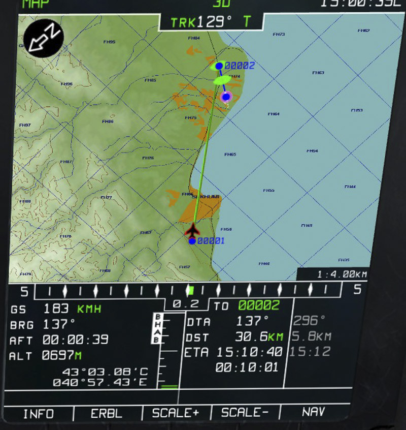
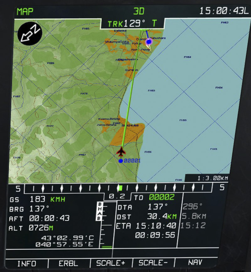
Yes, it is only that--just my opinion. The left screenie shows the terrain without the tree areas. The right one is zoomed in one more level. Notice the green areas appear where the forests are. I think it detracts from the terrain. It makes no difference, as my question was answered that it cannot be changed. Thanks.

-
Is there any way to remove the areas depicted as forests on the ABRIS when you zoom in to a certain level? I find that it makes it much harder to see the topography.
-
Think I might finally understand Trim problem!
ajax replied to doveman's topic in DCS: Ka-50 Black Shark
I sure would like to make one of those. Any links to instructions?