graveyard4DCS
-
Posts
149 -
Joined
-
Last visited
Content Type
Profiles
Forums
Events
Everything posted by graveyard4DCS
-

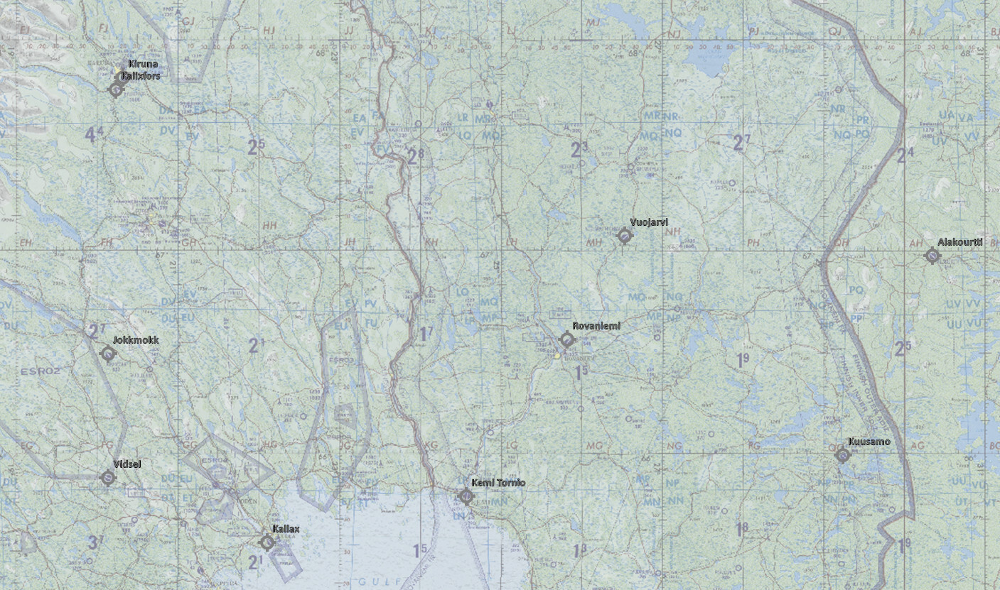
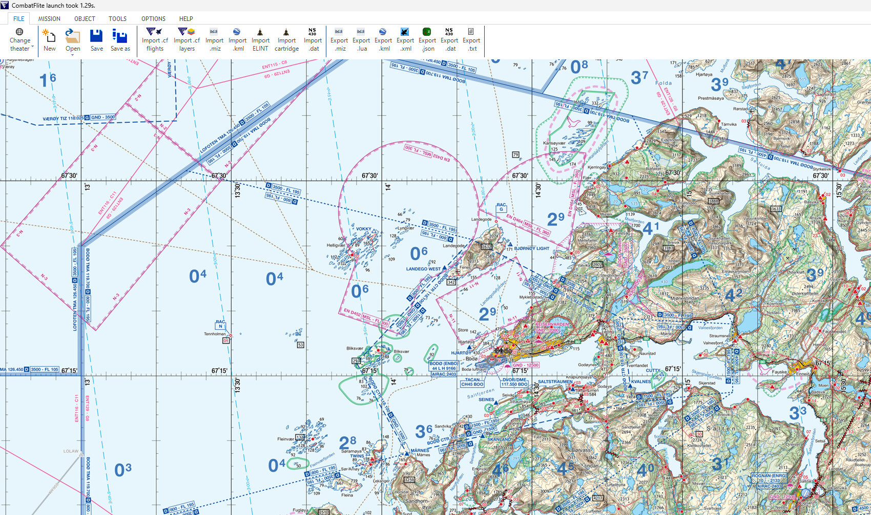
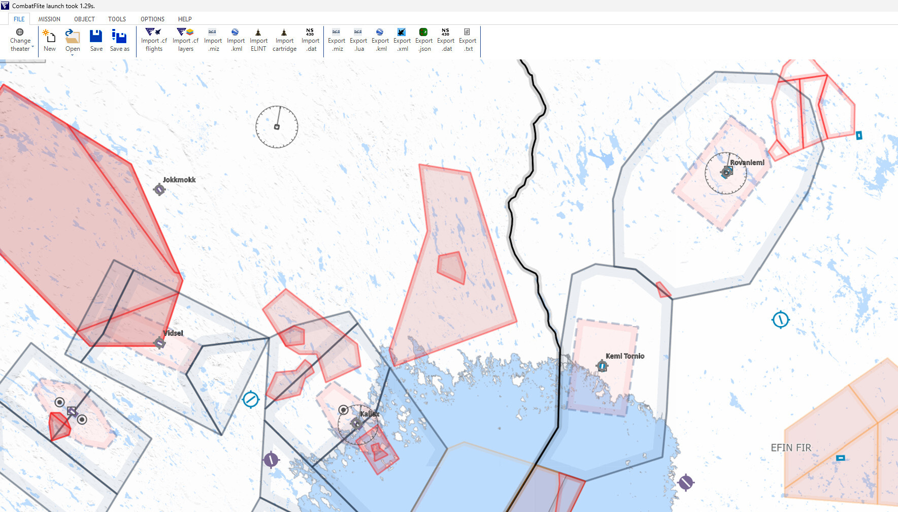
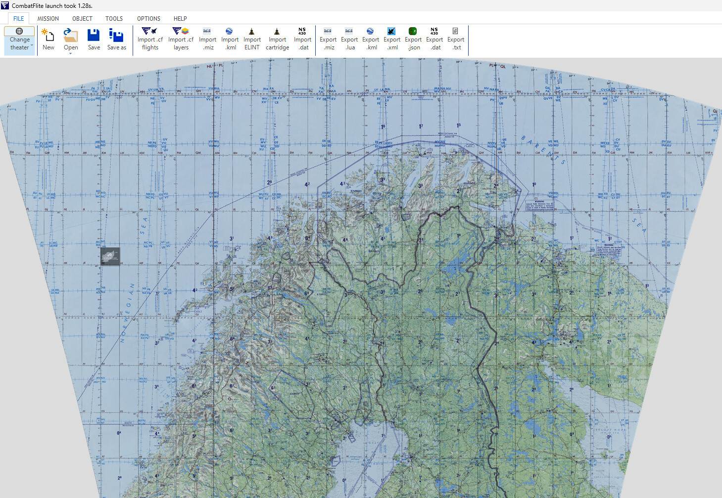
Kola - 1:1.000.000 ONC map for CombatFlite
graveyard4DCS replied to graveyard4DCS's topic in Orbx Simulation Systems
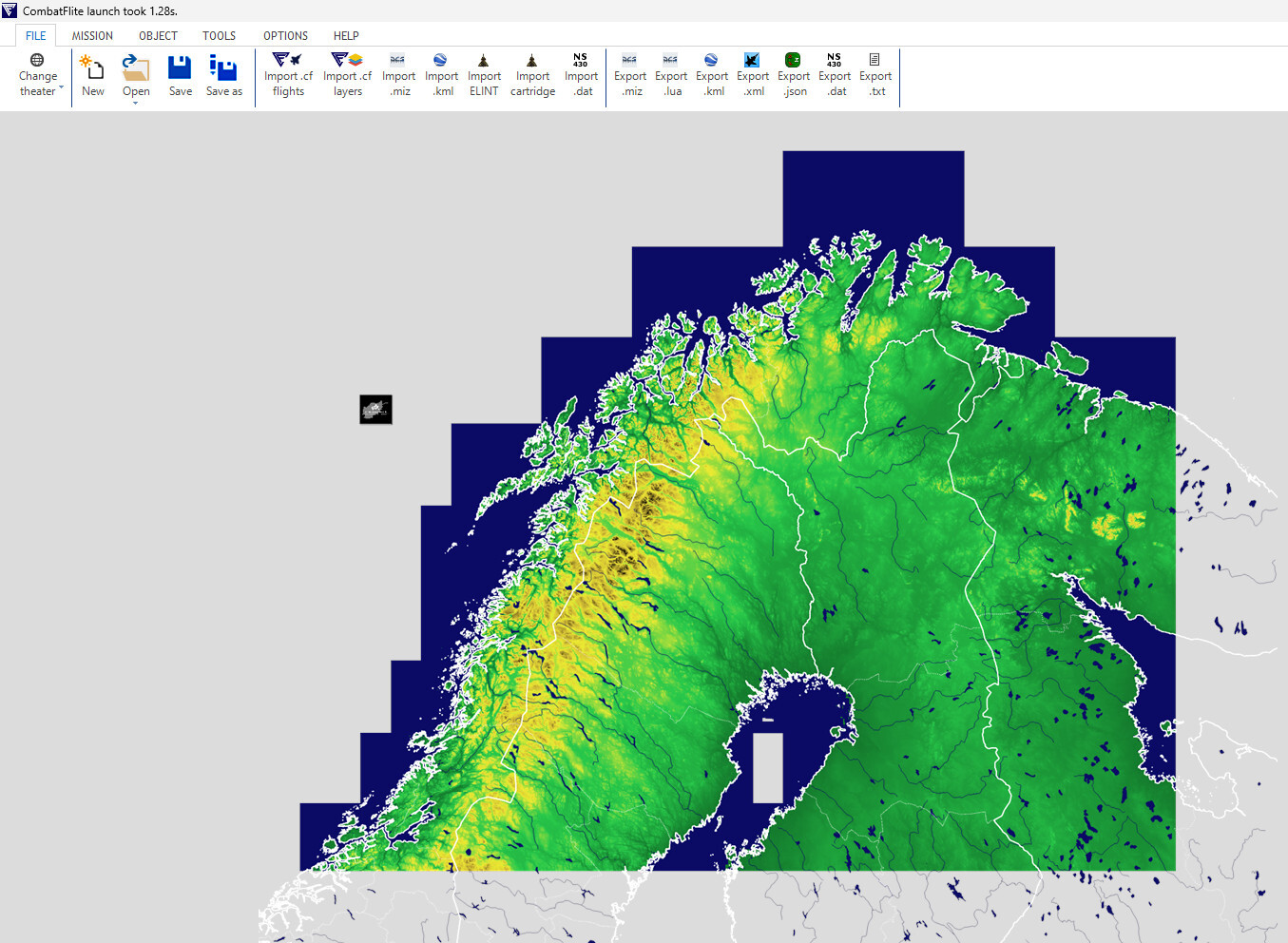
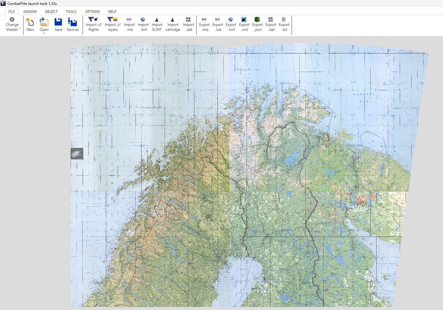
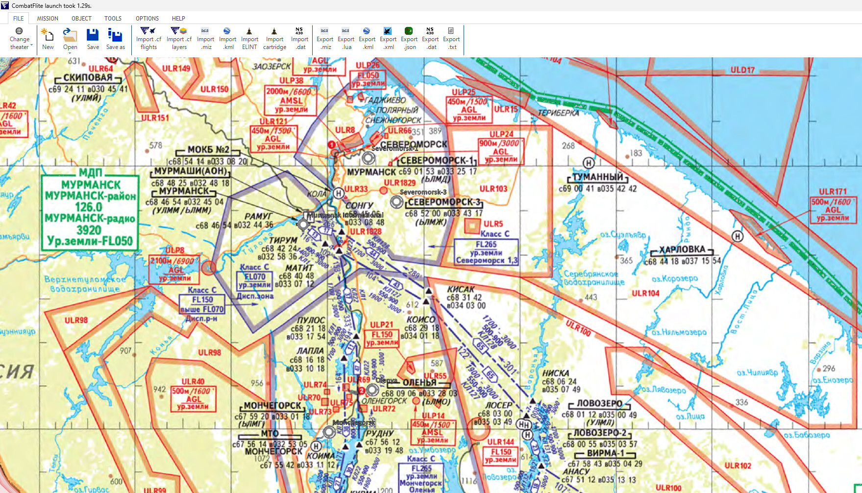
In the previous days, I released several other maps for use in CombatFlite: 1:500.000 TPC map Terrain elevation map 1:500.000 composite map with 2024 airspace for Norway, Sweden, Finland and Russian Federation All this with the .xml files and necessary information to create your own Kola theater in CombatFlite. Enjoy you mission planning on this amazing theater!
-
Quick head's up to let you now that the 1:1.000.000 ONC map for Kola theater is now available in DCS user's files. Enjoy your planning!
-
The terrain elevation map for CombatFlite is now available in DCS user's files: https://www.digitalcombatsimulator.com/en/files/3342400/ Enjoy your planning!
- 23 replies
-
- 1
-

-
- graveyard4dcs
- afghanistan map
- (and 2 more)
-
Basically, if you're using a DSU-33, at about 20 feet above the surface (depending on the angle of impact, type of surface, etc...), the DSU will tell your tail fuze to start the functionning delay. Knowing that a JDAM impacts at a speed of 250 to 300 m/s or 800 to 1000 ft/s, you can then determine the height of burst (HOB) above the surface: with a delay of 0 ms, HOB at 20ft, with 10 ms, HOB around 10 ft, with 25 ms, HOB around -5 ft, etc... Note that a negative HOB can be useful (but in very specific situations), for example if you're dropping your bomb above the forest canopy: an impact fuze won't be triggered when it reaches the treetop, but a proximity sensor certainly will be, and by knowing the height of the trees and the bomb's dive angle, you can calculate the delay required for the fuze.
-
Technically, the DSU-33 is a proximity sensor for installation in the nose fuze well of general-purpose warheads. So it is not a fuze in itself, but it is a sensor that triggers the beginning of the functional delay of the actual fuze. As stated before, it's particularly well designed for personal in the open and non armoured vehicles. More details here if you want.
-
Static Template for Helmand and Uruzgan FOB's
graveyard4DCS replied to PeneCruz's topic in Missions and Campaigns
Amazing (especially FOB Rhino)! -
Bomb Fuzes options in the rearming panel
graveyard4DCS replied to graveyard4DCS's topic in General Tutorials
I eventually took the time to regroup all the various articles already published on my personal page and publish them as a single pdf file. I also createded kneeboards that summarize recommended operational settings for the F/A-18C and the F-16C in DCS World. The kneeboards are better understood after reading the more comprehensive guide obviously, that's why the full guide is included with the kneeboards. Enjoy your reading!
-
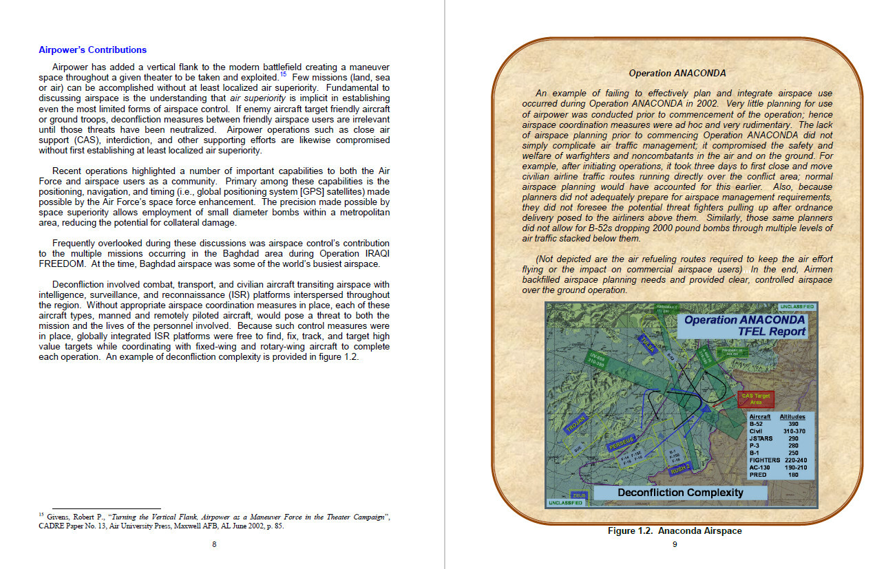
Several people showed interest in building an ACO (Airspace Control Order) for the Afghan theatre. For those who'd like to have an idea on how to build a realistic ACO, how to find historical data (like tanker's callsigns), and in particular where to place their tanker's tracks or at what altitude, you can have a look at my personal page. I tried to study all these topics in the previous days, and you might find valuable information if you want to recreate realistic missions. Example of OEF ACO view from AFDD 3-52, Airspace Control (2011) I started with a study of the early OEF phase (2001-2002), because at that time the overall situation was obviously simpler on the theatre, due to the absence of artillery or the rarity of civilian traffic. In ended up my analysis with an ACO proposal for that period. Enjoy your reading!
-
- 4
-
-
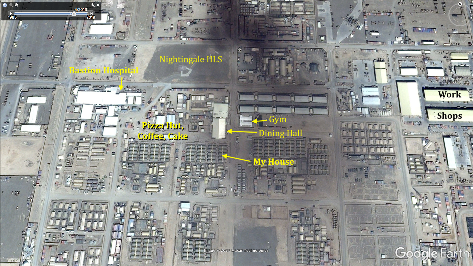
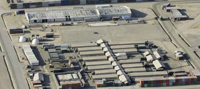
Hi, After 2008, the hospital and HLS were next to the black smoke, on the western side, on that Google Earth screenshot. Details on the following picture (found on another forum). If you are looking at a time period before 2008, then the field hospital was South of the white 2008+ building. On the following picture, you can see in 2007 both the field hospital (tents) and the building of the new hospital. Plenty of details here: https://www.friendsofmillbank.org/unit-histories/#gsc.tab=0 Eventually, you'll find the location of the various HLS on this base on my airport charts.
-
Mk 82 And Mk 81 : Can't set them properly
graveyard4DCS replied to BlackFalco's topic in User Created Missions General
Hi Indeed bombs' time of flight need to be higher than minimum fuze setting. If you are trying to do something that's realistic tactically speaking, don't forget that a low drag bomb dropped level in very low altitude has a very high chance of bumping on the ground (ricochet) and hit back the aircraft. Even if it's exploding when hitting the ground, the aircraft will definitely be within the fragmentation envelope and has high chances of being destroyed by its own bomb's explosion. The only option to make something that's both technically possible (TOF long enough to arm the bomb) and tactically sound is to use high drag bombs. -
I'll check it, thanks
-
Hello m, Just for info I documented most of the fuzes in this post : You can also check my personal page for additional details.
-
Hello Just for info I documented most of the fuzes in this post : You can also check my personal page for additional details.
- 16 replies
-
- 1
-

-
- bomb fuze
- bombs fuze
- (and 2 more)
-
Hello, Just for info I documented most of the fuzes in this post : You can also check my personal page for additional details.
-
Hi, Just for info I documented most of the fuzes in this post: You can also check my personal page for additional details.
-
Bomb fuze update - where is the documentation?
graveyard4DCS replied to AndrewDCS2005's topic in DCS 2.9
Hi, Just for info I documented most of the fuzes in this post: You can also check my personal page for additional details. -
Hi, Just for info I made a comprehensive research work on bomb fuzes. I reported some of it in this post: Don't hesitate to contact me directly if you want me to provide ED with info for the DCS manual.
-
Bomb Fuzes options in the rearming panel
graveyard4DCS replied to graveyard4DCS's topic in General Tutorials
For those interested, I published additional data regarding FZU-39 used in BLU-87/103 and BLU-97/105. I also created a kneeboard page with all recommended settings for the F-16C in DCS world, on the same model as the one I made for the F/A-18C (see my previous posts) . -
Do you know CGRS reference system?
graveyard4DCS replied to graveyard4DCS's topic in DCS: Afghanistan
Practical Use of CGRS Grid During Operation "Enduring Freedom" During Operation Enduring Freedom, the CGRS system was extensively used for a variety of operational purposes to enhance coordination, situational awareness, and target management. Here are some of the situations in which CGRS was employed: 1. Airspace Management and Deconfliction: CGRS provided a standardized grid system that could be easily referenced by all coalition forces, allowing for precise coordination of airspace usage. It was particularly useful in managing close air support (CAS), airstrikes, and unmanned aerial vehicle (UAV) operations. CGRS killboxes were assigned to specific air tasking units to control aircraft operating in defined areas, preventing mid-air collisions and friendly fire incidents. Killbox interdiction: CGRS was used to assign responsibility for monitoring and striking targets within specific killboxes, simplifying the process of dynamic targeting or interdiction (targeting enemy forces or resources in motion). 2. Indirect Fire (IDF) and Artillery Coordination: The system was critical for the coordination of indirect fire support (e.g., mortar, rocket, and artillery strikes) because it allowed ground units to quickly activate a ROZ (Restricted Operating Zone) and call for fire while ensuring deconfliction with airborne assets. For instance, in the report discussed earlier, grid references and CGRS killboxes like 88CR and 89CR were used to call in artillery fire, ensuring that supporting units could deliver fire on the correct target quickly and safely. 3. Close Air Support (CAS) Missions: During CAS missions, pilots and Joint Terminal Attack Controllers (JTACs) would use CGRS grids to designate specific working areas, in order to deconflict betwen multiple flights working in a close proximity. CGRS killboxes were often used in pre-planned or on-call CAS missions, where aircraft were assigned to specific killboxes. Passing a CGRS grid is a very quick and effective way of tasking a unit, without going to the details of 5 digit MGRS grids. It enabled a quick relocation of assets, prioritizing efficiency over precision in a first time. In a second time, while contacting the JTAC, an updated MGRS grid would be passed to share the latest situation with aircrew. 4. Air-Ground Coordination in Joint Operations: CGRS facilitated air-ground coordination by providing a common language that ground units, air controllers, and pilots could use to communicate quickly and accurately. This standardization was essential given the coalition nature of the forces involved, where different nations' military units might be working together and needed to ensure effective communication across languages and technologies. We can note that these use cases apply both to planning and execution phase. In the planning phase, for example, CGRS Grids would be used to assign a working area on the daily ATO. It would also be used for a JTAC to book an area for pre-planned CAS, while filling up his JTAR for example. During the execution phase, CGRS Grids would be used by ground forces to declare a ROZ, and enable the use of artillery. In this situation, the CGRS Grid beacomes a tool to create Airspace Control Means (cf. AJP-3.3.5 about Airspace Control for more details about ACMs). Real-time air support requests from ASOC, that are transformed into retasks after AOC approval, via C2 agencies, would also be passed more efficiently by assigning air asset to a new grid cell, instead of giving a full coordinate. Here would be an example of dialogue between the controlling agency and a fighter jet to pass a new task: Crowbar: "Dude 51, Crowbar. We have a new task for you. Go secure." Dude 51 : "Roger, Crowbar. Going green." Crowbar: "Dude 51, immediate retask. Proceed to 84-CI, support TIC A-12. On station, contact Widow TOC on Amber 12 frequency for situation update. Say ETA and playtime when able." Dude 51 : "Crowbar, Dude 51. Copied, new task: support TIC A-12 in 84-CI. Contact with Widow TOC on Amber 12. Stand-by for ETA and playtime." Dude 51 : "Crowbar, Dude 51, ETA 15 mikes, playtime 1 hour. We request AAR with Shell 41 at 04:30Z to be moved in E-Sunny instead of E-Brownie if possible" Crowbar: "Dude 51, copied, stand-by, coordinating with Shell 41." [...] I hope these details and examples helped you understanding how and when CGRS grids would be used. Practically speaking, for mission creators, a realistic way to emulate retasking would be to transmit the CGRS cell instead of the full MGRS coordinates. Then only once in contact with JTAC on another frequency would the full grid be passed. If the transit to target area is long, however, the C2 agency would have enough time to pass a full MGRS grid. You can find out how to rebuild the real CGRS grid for Afghanistan on my page, as well as full scale maps with the grid, along with overlays for CombatFlite and Tacview.
-
Hello! Do you know what JTAR and ASR are? And do you know the difference between the two? JTAR stands for Joint Tactical Air strike Request, while ASR stands for Air Support Request. And both are basically the same. JTAR will be the preferred term in US forces, while ASR is more a NATO term... And that's all! Left: US JTAR, right: NATO ASR. But what are they exactly? A JTAR or ASR is a form in joint military operations, used by ground units to request close air support (CAS) from air assets. Submitted via a standardized form, it enables coordination of tactical air strikes to support ground operations, such as neutralizing hostile forces or protecting friendly units under fire. JTAR/ASR are organized into preplanned and immediate requests, each suited to specific combat needs. Preplanned JTARs are scheduled in advance and typically included in the daily Air Tasking Order (ATO) cycle, which assigns air missions for optimal synchronization with ground movements. This type of JTAR ensures that air assets are prepared with the necessary intelligence, ordnance, and targeting data to support ground operations at the designated time and location. Pre-planned ASR: the request goes up all the chain of command, before being selected for tasking in the ATO (48h cycle). In contrast, immediate JTARs respond to unanticipated threats, often emerging from dynamic combat conditions where ground forces urgently need air support. Immediate requests are processed through a quick coordination cycle, redirecting available CAS aircraft or diverting other missions to provide support in real time. These requests prioritize emergency response but can increase operational risks, such as collateral damage, due to the limited time for detailed preplanning. Immediate ASR: the request can skip some echelons of the chain of command, and can be introduced in real time in the execution cycle. The immediate CAS cycle as described by the US doctrine. By filling out the JTAR accurately, requesting units provide essential data on target location, munitions, and mission timing, enabling air support units to respond effectively. The JTAR ensures all involved echelons are aligned, enhancing the safety and precision of air strikes and supporting ground maneuverability in complex combat scenarios. Therefore, if you are preparing a pre-planned CAS mission for DCS World, be sure to fill in a JTAR/ASR form that will be used by the crew for mission planning! References: US Joint Publication 3-09.3 - Close Air Support and NATO ATP-3.3.2.1 - Tactics, Techniques and Procedures for Close Air Support and Air Interdiction. Note: the scope of NATO's ATP-3.3.2.1 is broader than US JP 3-09.3 since the first one includes Air Interdiction (and in particular SCAR missions), that is out of the scope of the US Joint Publication...
-
Hi. On the topic of contrails, it would be nice to have a prediction model, or a tweaking option, to know when they start and when they end. Contrails forecast maps are a standard military aeronautical weather product that is systematically used for tactical planning. These map show for various locations in the AOR the high probability of contrails altitude blocks. Thanks
-
More Details about CGRS Grid For those who did not know them, I explained in an earlier post the differences between the various military coordinates reference systems. I started by detailing the MGRS grid, because it is already used by default in DCS World, when working with a JTAC for example. It's an excellent tool for working closely with ground forces and on a small scale, but MGRS coordinates are not the best suited to the perspective of air operations, particularly at the operational level. For the purposes of planning and executing air operations, the CGRS system was preferred. With the CGRS system, each 30‘ by 30’ grid in the area of responsibility is given a unique name, normally consisting of digits for the North/South position, and one or more letters for the East/West position. Then, within this 30‘ x 30’ square, a "keypad" can be defined, with each 10‘ x 10’ sub-square identified by its number, just like the number pad on your keyboard (unless that they are not on the same order...). For example, 1 is the top left corner, 5 is the centre and 9 is the bottom right corner. If an even more precise location is needed, each keypad can be divided in 5' x 5' squares, called "Quadrants". In general, CGRS grids use letters to name the longitude (East/West) and figures to name the latitudes (North/South). What needs to be defined for a given theatre of operations is the reference, i.e. the location of the "A1" cell. On the example below, taken from "Desert Storm" operation in 1991, you can see that letters are used by pairs, and that Kuwait city is in 05-AG. If we believe that this grid was used only for operations in south-east Iraq and Kuwait, then we can say that the origin of this grid (01-AA) is in N 27°00' E 044°30'. If we think that a larger grid was used, including all of Iraq and starting in A instead of AA, then the origin is in N 27°00' E 031°30'. Regarding Operation "Enduring Freedom" and Afghanistan, we can easily see that such a grid was also in use. For that, we can just take a look at any Wikileak's mission report mentioning killboxes. Here we'll see that the killboxes are identified using their CGRS Cell and Keypad: 88-CR-3 and 89-CR-9 in the example below. We can check that the 2 keypads 88CR3 and 89CR9 are adjacent if we assume that 88/89 designates latitudes and CR designates longitudes. On my personal page, I will explain you how to build the full CGRS Grid for Afghanistan, and tell you how this system was used for air missions planning and execution.
-
Hi. Just for info you can have more details about bomb fuze here, and even more related to the F/A-18 case on my personal page. Enjoy!
-
Direct download of the TPC map for Herat area is now possible in user's files: https://www.digitalcombatsimulator.com/en/files/3341084/ All the 1:500.000 TPC maps covering most of south-west Afghanistan are available on my personal page. Please let me know if you have any comments about the readability of the MGRS overlay. I can also create maps for specific areas on request, to support mission designers for example. Don't hesitate to discuss it directly with me if interested!
-
Direct download of the ONC map is now possible in user's files: https://www.digitalcombatsimulator.com/en/files/3340991/