toby23
-
Posts
696 -
Joined
-
Last visited
-
Days Won
9
Content Type
Profiles
Forums
Events
Everything posted by toby23
-
Thanks to all who worked on 1.1.0.9 It resolves a whole bunch of issues and I'm getting a noticeably smoother flight too. Thanks for crunching and getting it out at the weekend. Toby
-

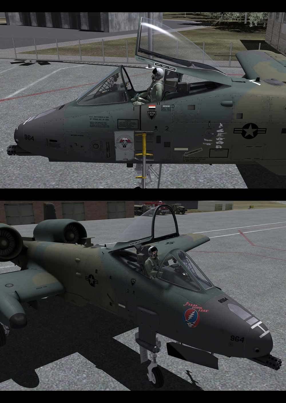
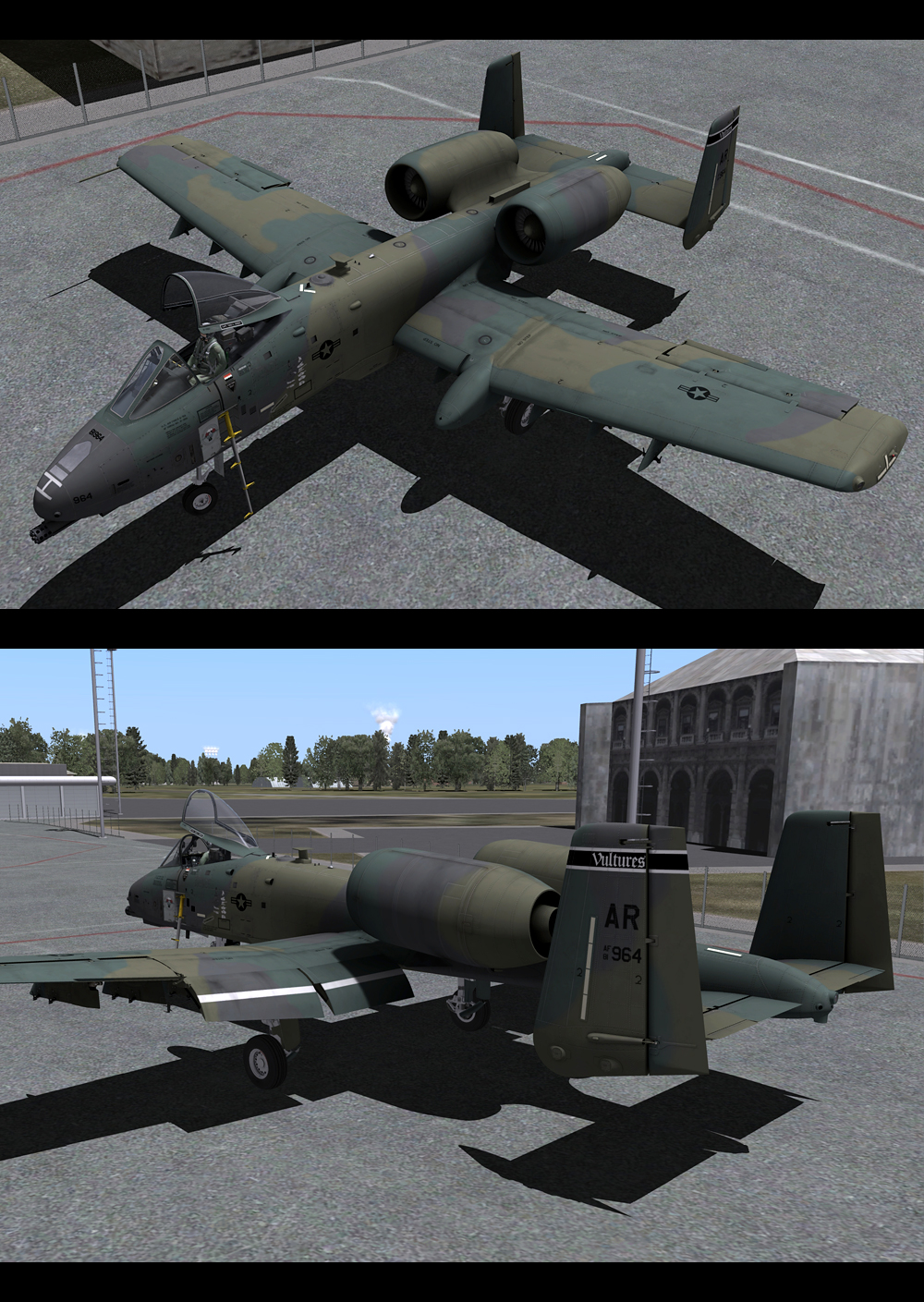
New Skin - 81-0964 'Steal your face' - UK Camouflage
toby23 replied to toby23's topic in Utility/Program Mods for DCS World
I created the camouflage, decals and details. The basic template was provided by DCS. Glad you like it, it was a labour of love. -
My first livery for the A-10C based on a real life A-10A. Download from the User Files Section HERE. My thanks to Barry Munden for his help with the history and decals of this plane. Enjoy

-
Taken last night on mission 9-2-0 Georgian Hammer Campaign.
- 1 reply
-
- 1
-

-
Scheffchen, don't go expecting too much more. A second GTX 580 will really only be worth it if you run multiple monitors or at resolutions above 1920x1200. A fast cpu, at least 4.5ghz, and fast ram is probably a better investment if you run below 1920x1200.
-
Boris. I run at 2560x1600 resolution with 4x multisampling (in game) and 2x transparency supersampling (forced in control panel) as well as using custom distance settings. That's why I run SLI. I did run with one GTX 580 but things slowed down too much at this high resolution. Up to 1920x1200 you should be find with one GTX 580. Good luck
-
I never had the problem at 60000.
-
I agree and I have updated the guide to show this.
-
EDIT 26/07 80000 is more than enough After changing noise1back to 60000 to sharpen up the the ground textures, I wondered why the mountains still looked so blurry at the start of the CSAR mission. I have worked out that you have to change 2 values, not just one. You need to change distance10x10 too, here's how... In the terrain settings file - DCS A-10C\Config\Terrain\Low/Medium/High.lua Line 3 - Change 30000 to 80000 distance10x10 = 30000Line 39 - Change 20000 to 80000 noise1back = 20000Save the file and fire up the CSAR mission again... Clear ground textures as far as the eye can see, with no visible performance hit. Click the animated GIF below to see more. Happy hunting PS I run the sim at 2560x1600 resolution on 30" monitor.
-
Thanks people, please re-download, error in weight corrected. A 10,000lb CBU-105 would be nice but it's not big and it's not clever... Thanks
-
----------------------------- 07/08 Important Update ----------------------------- Please download the Combined Document Pack from HERE to obtain this file Updated 25.07 I've made a Weapons Guide, more as a learning tool than for quick reference. It's attached in PDF format for those of you who want to learn more. I highly recommend reading 'Fire Strike 7/9' to learn more about the employment of various weapon types. Happy hunting --- Images and Figures from DCS Manual, USAF, Wikipedia, Northrop Grumman, FAS.org
-
I used THIS file and managed to complete the mission 7-2-0. I had AWACS tuned to 123.0, instead of 124.0, unless I really had to use it, to avoid a wradio.dll crash.
-
Crashing Mission 7-2-0 Me too.. Georgian Hammer Campaign Mission 7-2-0 Last night Fault Module Name: ntdll.dll Tonight Fault Module Name: wRadio.dll Faulting application name: dcs.exe, version: 1.1.0.8, time stamp: 0x4de5047a Faulting module name: ntdll.dll, version: 6.1.7601.17514, time stamp: 0x4ce7c8f9 Exception code: 0xc0000005 Fault offset: 0x0000000000053560 Faulting process id: 0xc08 Faulting application start time: 0x01cc43339b01335d Faulting application path: C:\Program Files\Eagle Dynamics\DCS A-10C\bin\dcs.exe Faulting module path: C:\Windows\SYSTEM32\ntdll.dll Report Id: b13d4c1b-af28-11e0-b2e8-f46d0415b19f Faulting application name: dcs.exe, version: 1.1.0.8, time stamp: 0x4de5047a Faulting module name: wRadio.dll, version: 1.1.0.8, time stamp: 0x4de5047a Exception code: 0xc00000fd Fault offset: 0x0000000000047307 Faulting process id: 0xacc Faulting application start time: 0x01cc43fd9cda685e Faulting application path: C:\Program Files\Eagle Dynamics\DCS A-10C\bin\dcs.exe Faulting module path: C:\Program Files\Eagle Dynamics\DCS A-10C\bin\wRadio.dll Report Id: a9dfdb47-aff2-11e0-82cb-f46d0415b19f
-
Lochini-Tibilisi Tower 138.0 RWY 13 - ILS 110.30 RWY 31 - ILS 108.90
-
Update for UFC texture (based on real life photo)
toby23 replied to toby23's topic in Utility/Program Mods for DCS World
Found the info - http://forums.eagle.ru/showthread.php?t=76188 -- -
Hassata, that would be great. Please pm me, thanks.
-
Thanks Laud, This book is sold out everywhere I think, so I need someone who would sell me their copy.
-
I am looking for a copy of The Modern Hog Guide: The A-10 Warthog Exposed. Unfortunately it's out of print, the publisher's sold out and even the author, Jake Melampy, wasn't able to help me find a copy. If anyone would like to sell me their copy, I would be extremely grateful. I plan on using it to redo the exterior and interior textures as well as learning more about the Hog. I am aware that there is a copy on Amazon.com for $300,- but I won't pay that much. Thanks
-
Thanks Viper, That's the edit I meant. I have mine set to 5.0 and that's pretty close to real life. It does get really unstable at full zoom though. Now we just need an anti-shake mod.
-
Sorry to not be of much use but somewhere on this forum, I searched and couldn't find it, there is a post that explains how to edit the Zoom level so that it simulates binoculars. I'm reading a book by an A-10 pilot who flew in the Gulf War and most of the pilots carried binoculars, so no, you're not cheating...
-
Thanks Andy, that last link cleared it up for me.
-
Andy, you're right. I was in GG but I don't understand how I am supposed to enter to tell the CDU I'm on the other grid? I only have the coordinates JTAC gives me. I've read through the document you linked but I still don't get it. What am I missing?
-
Last night, I played Mission 6-1-0 in the Georgian Cross and there were 2 JTAC's as well as a Predator UAV giving me targets. Everything was going ok until JTAC started giving me 5 digit coordinates, which threw up an error on the CDU. I have read about this problem, so I tried entering the coordinates with a 0 in front, then again in position 4 but this provided me with targets marked on the HUD as up to 400nm away. I checked the area in my reference card (below) and in Google Earth, using the first two letters and numbers, KN79, and the target wasn't 400nm away but it was still more than 100nm from my current position. After JTAC 1 was killed, JTAC 2 and the UAV controller continued to provide me with targets over 400nm away six times. If JTAC gives me the coordinates KN82264, what do I have to enter as a UTM waypoint - KN082264 OR KN822064? Because I tried both of these and the HUD showed roughly 400nm to target both times. I have read several posts on here about this problem but I don't understand if I am the problem, JTAC doesn't like me or if it's a bug. Thanks for your help.
-
How do I remove a JTAC red triangle from the TAD?
toby23 replied to toby23's topic in DCS: A-10C Warthog
Thx Viper. Will try later. -
When you receive incoming target data from JTAC, a red triangle flashes on the TAD which you can hook. During a longer sortie, the TAD screen can easily have three or more red triangles visible and the next time that you receive a target area from JTAC, it's very hard to remember which ones you have cleared and which is the new one because they all flash when receiving new data. Q. Is there a way to remove the red triangles from the TAD? I know how to unhook a target but I can't figure out how to remove the red triangles. Thanks.