
Leviathan667
-
Posts
339 -
Joined
-
Last visited
Content Type
Profiles
Forums
Events
Everything posted by Leviathan667
-
Thanks.
-
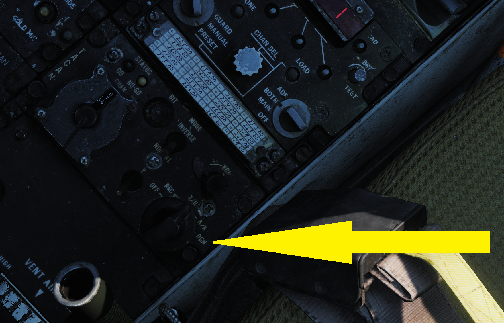
Hi, I've been looking for answers on those two topics: Has TACAN BCN it been implemented? If so, how does it work (the manual does not cover this)? And does BCN stand for beacon, meaning I can set my plane as an AA TACAN station for others to look for? Does TWS MAN allow for the RIO to establish the targets order of engagement or only the radar antenna elevation? I noticed the TWS AUTO does not attribute an order of engagement to enemy tracks anymore and read somewhere this functionality has been disabled. Is it true? Thanks

-
I am sorry but I tried and it does not work. Maybe a more detailed explanation (step by step, including the most minute detail) would help?
-
Just launched the RB-04E over the sea and it works. Both cargo ships were taken down. So I guess the terrain following feature of the missile is not working.
-
I made a track and a video showing what's going on with an overland launch of the RB-04 (it goes straight to the ground as if it had no radar altimeter). Over hilly terrain: Please, see this video : Over flat land: And the TRK files attached to this post. Is it a bug or is it normal? RB-04E_test_hilly_terrain.trk RB-04E_test_flat_land.trk
-
This is what happened to me yesterday except I launched from a higher AGL altitude but there were small hills on the path of the missile to thr ships.
-
Follow up question: Does the Weapon safety height parameter in the mission editor affect the RB-04 flight altitude? (See p. 378 of the RC manual).
-
I'd like to verify my understanding of how the RB-04E behaves. According to the manual, as soon as they are launched, they descend to 10 m above sea level (ASL) and then proceed to fying in the same direction as the launch vehicl (unless a radar fix has been made on the target waypoint). So it is not possible to launch RB-04s while flying overland because the ground altitude is almost certain to be 10 m ASL. Is the reasoning correct? BTW, how does the missile determine what is the MSL? Does it follow the same QFE setting as the launching platform? If the answer to the previous question is positive: if the launching platform's QFE is set to a value that reads 0 meters on the altimeter at the level of the highest ground protuberance (e.g. 200 m ASL) on the missile's path (before reaching the sea), will the missile descend to 210 m ASL instead of 10 m? If the answer to the previous question is positive: it follows that from the missile's perspective ASL will be high enough to let it fly overland without crashing before reaching the sea. But, will the active seeker still be able to detect the enemy ships since from the missile's perspective, they will be 200 under the sea level? Thanks for your help.
-
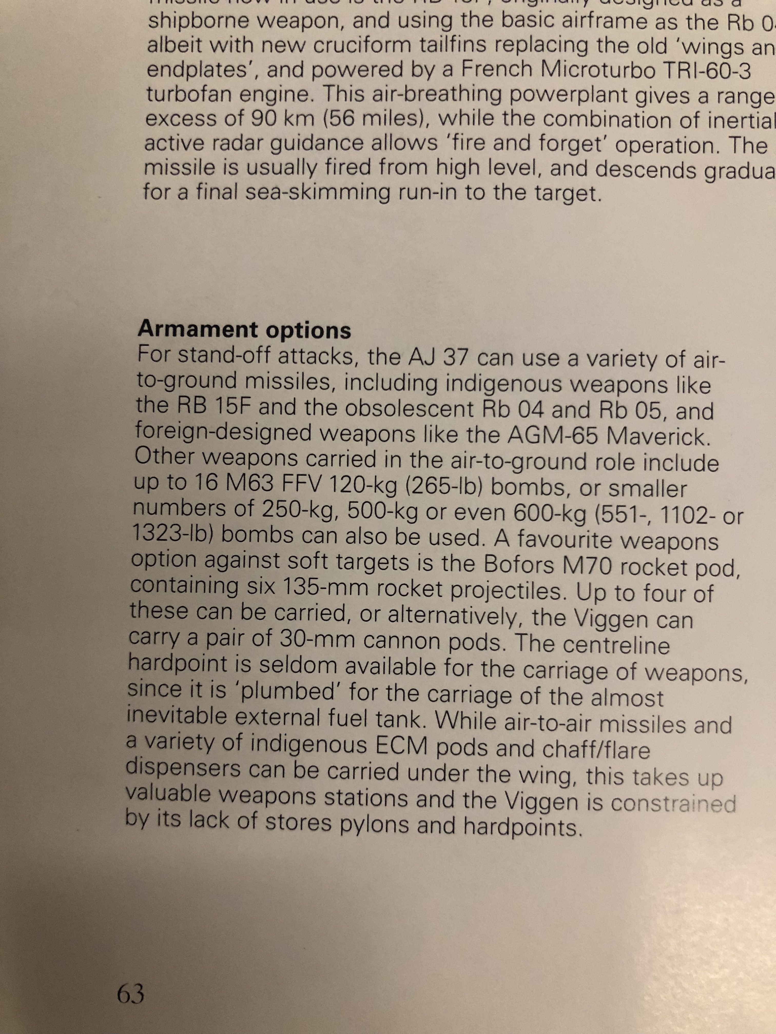
250, 500 and 600 kg bombs for the Viggen
Leviathan667 replied to Leviathan667's topic in DCS: AJS37 Viggen
Thanks for the info. But then what in the swedish doctrine made heavier bombs unnecessary? -
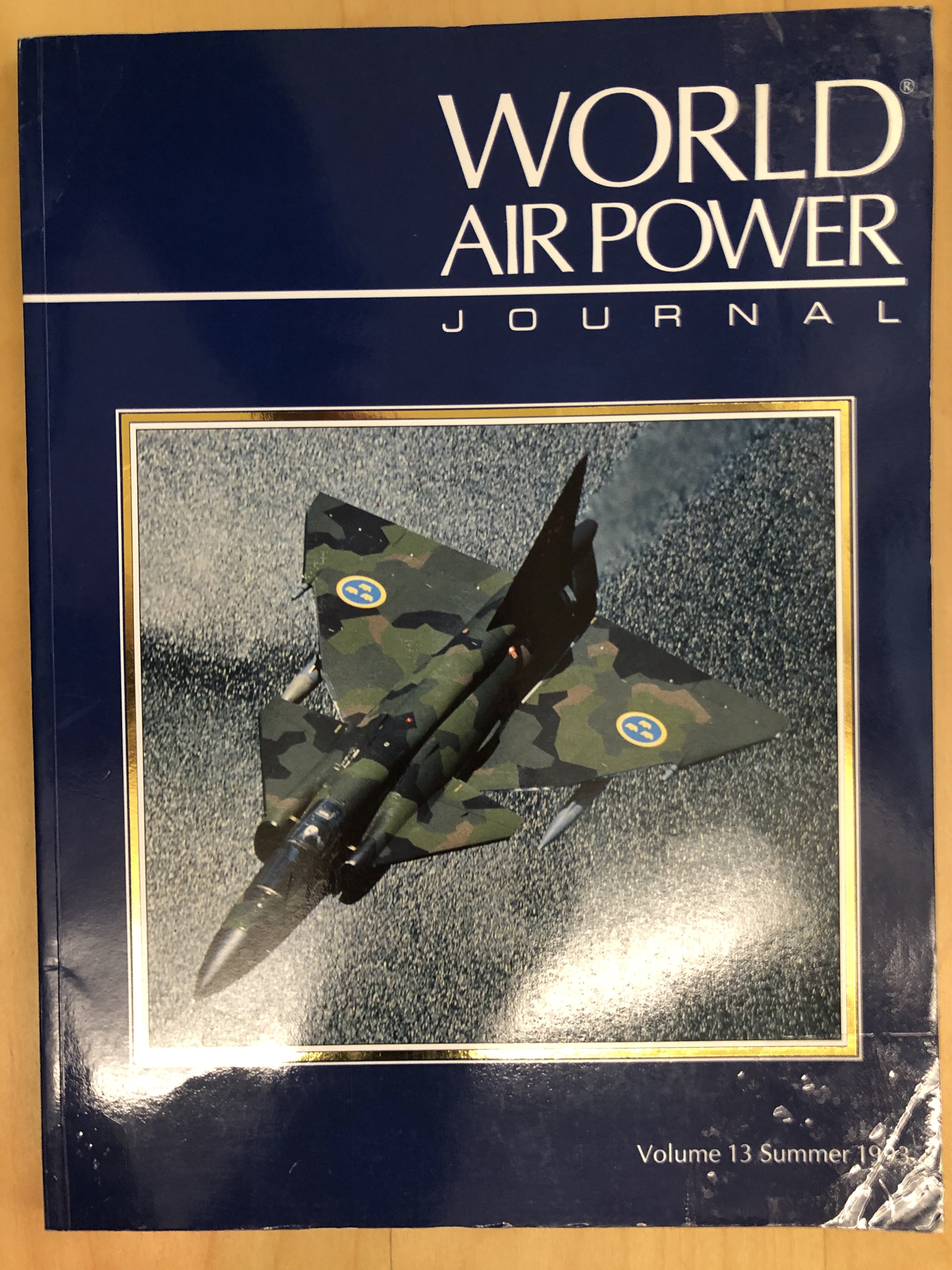
I've been reading World Air Power Journal Volume 13 (1993). Within it is a lengthy and detailed article on the Viggen. I was surprised to read the Viggen, starting with the AJ 37 version, can carry, not only SB 71 120 kg bombs (aka M63 FFV bombs), but also 250, 500 and 600 kg bombs (see pics). Does Heatblur intend to make these heavier bomb loads available to the DCS Viggen?
-
Watch me (try to) fix/investigate something in the Viggen!
Leviathan667 replied to RagnarDa's topic in DCS: AJS37 Viggen
Great idea! -
Thank you all for your comments. I guess I was mistaken when I thought wind direction meant where the wind was going to as it actually is where the wind comes from. Also I read a few forum posts where people report the wind direction in the mission editor is wrong because it shows where the wind comes from insteading of where it is headed. This too is fueling my confusion. On a similar matter, the ATC does not always seem to properly take the wind into account. For example, in a custom made mission, at Senaki, there's a 348° wind according to the mission editor (coming from 348, heading towards 148) but ATC still has planes take off from runway 09 (94°) instead of runway 27 (274°). The idea here is to take off towards the wind as much as it is possible. So I thought we should want the difference, in absolute value, between our heading on the runway and the wind to be as close a 180° as possible. E.g.: |094-148| =54 |274 - 148| = 126 Am I in the wrong here? What do you think?
-
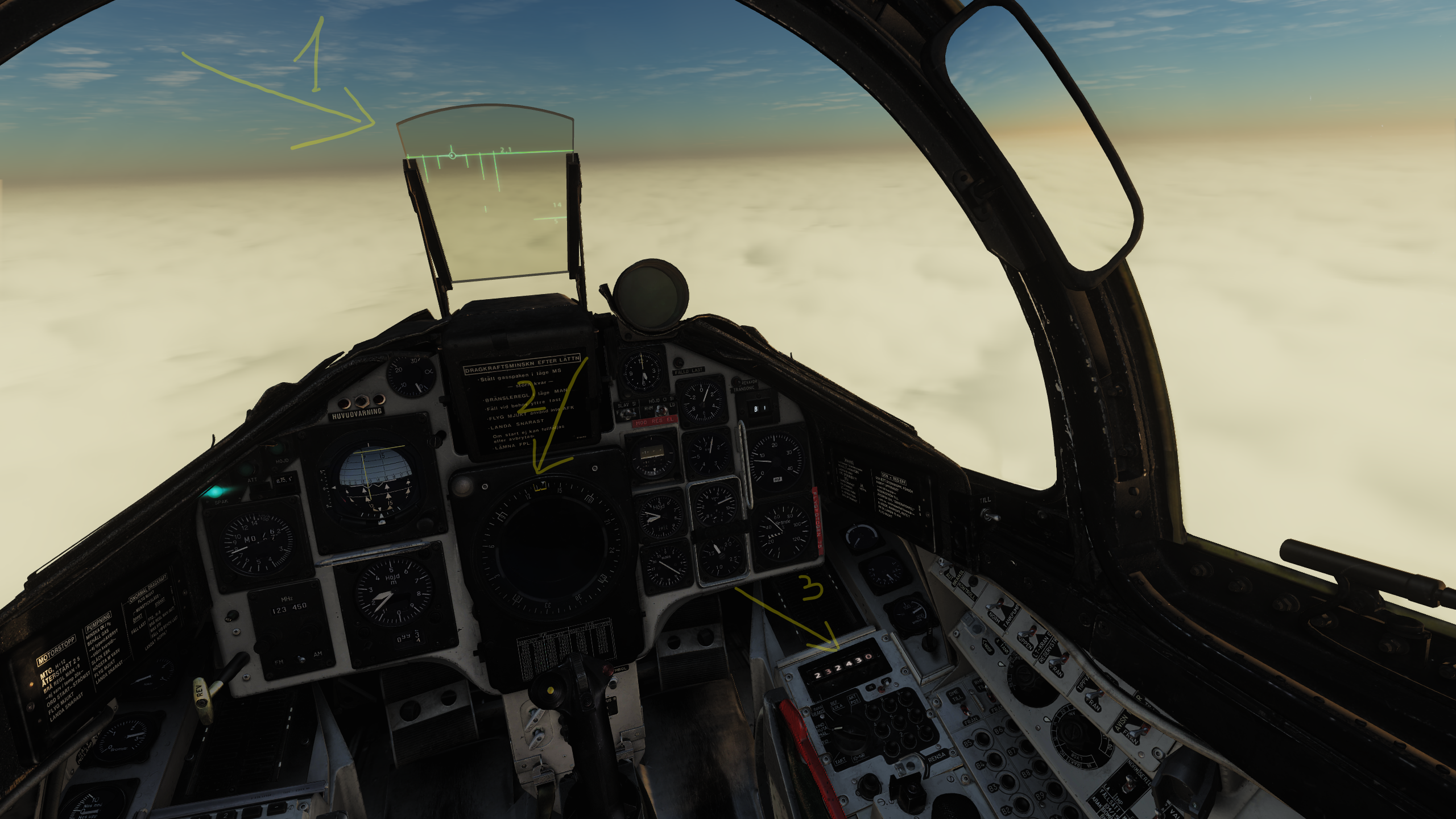
Wind direction in VIND/RUTA/MAL does not agree with course ring & HUD According to the manual, switching the data selector to VIND/RUTA/MAL will show: But, in the game, it seems VIND/RUTA/MAL show not the wind direction but the opposite (wind direction + or - 180°). On the attached screenshot, the wind direction is, according to VIND/RUTA/MAL, 232° at 43 km/h. Since the plane’s heading is roughly 136°, then the wind is pushing the plane to the right. BUT On the HUD, the steering command to waypoint B1 is veering to the left meaning the aircraft’s nose is pointed slightly to the right of its flight path. My understanding is this happens because the wind is pushing the plane to the left. The wind’s real direction seems to be 52°, not 232°. Further confirmation comes with the fact the course ring shows that the nose of the plane is heading towards 136° whereas the waypoint direction is slightly to the left, at 132°. Still, the FPM shows the aircraft is actually heading towards the B1 waypoint. In other words, to fly towards the waypoint, the plane’s nose has to be pointed slightly to the right of its desired flight path. This also suggests the wind’s real direction is 52°, not 232°. The same line of reasoning is also supported by the steering command on the ADI. So I am either wrong and would like to know what is the correct understanding of these readings or the manual is wrong and VIND/RUTA/MAL is not supposed to show the wind direction or the information displayed in VIND/RUTA/MAL is wrong and should be corrected to show the actual wind direction.
-
Any good suggestions for a road base in the Caucasus map?
Leviathan667 replied to corvinus's topic in DCS: AJS37 Viggen
Hello, Made a list of suitable locations for road bases: North of Gorovani, to the northwest of Tbilisi 087 - 267 (orientation) Length: 14 947 ft 4 556 m Width: 21 ft 6.4 m 1 903 ft - 1 932 ft (altitude variation between both ends of the road base) 580 m - 589 m When landing on strip 87(entry point, for example, tu put a ref. point on the map): 44° 37’ 14” E 41° 53’ 51” N When landing on strip 267: 44° 40' 30" E 41° 53' 40" N North of Goraberezhouli, east by northeast of Kobuleti AB 079 - 259 Length: 3 740 ft 1 140 m Width: 21 ft 6.4 m 374 ft - 394 ft 114 m - 120 m When landing on strip 079: 42° 11’ 01” E 42° 00’ 55” N When landing on strip 259: 42° 11’ 52” E 42° 00’ 58” N May need to clear a few trees in the mission editor Close to the town of Adzhapsha, east of Gudauta AB 94 - 274 Length: 5 725 ft 1 745 m Width: 43 ft 13.1 m 49 ft -52 ft 15 m - 16 m When landing on strip 94: 40° 43’ 49” E 43° 05’ 20” N When landing on strip 274: 40° 45’ 01” E 43° 05’ 30” N May need to clear lighting and electric poles If landing on strip 274, have to jump over a 2 700 ft (823 m) mountain that lies on the axis of the runway or take an indirect approach from the southeast 1st runway, south of the town of Shindisi and north the town of Variani, about 13 km to the south of Tskhinvali 152 - 332 Length: 4 077 ft 1 240 m Width: 21 ft 6.4 m 2 320 ft - 2 280 ft 707 m - 695 m When landing on strip 152: 44° 01’ 11” E 42° 07’ 02” N When landing on strip 332: 44° 01’ 29” E 42° 06’ 25” N Must remove lighting and electric poles 2nd runway, south of the town of Shindisi and north the town of Variani, about 13 km to the south of Tskhinvali 156 - 336 Length: 2 230 ft 680 m Width: 21 ft 6.4 m 2 238 - 2 215 ft 682 m - 675 m When landing on strip 156: 44° 01’ 48” E 42° 05’ 42” E When landing on strip 336: 44° 01’ 56” E 42° 05’ 21” N Must remove lighting and electric poles 11 km from the Inguri dam to the north (Shangri La road base) 019 - 199 Length: 2 900 ft 884 m Width: 21 ft 6.4 m 1 847 ft - 1 916 ft 563 m - 584 m When landing on strip 199: 42° 01’ 36” E 42° 51’ 37” N When landing on strip 019: 42° 01’ 20” E 42° 51’ 11” N Must remove trees, lighting and electric poles Immediately south of Kutaisi 176 - 356 Length: 6 155 ft 1 876 m Width: 21 ft 6.4 m 469 ft - 400 ft 143 m - 122 m When landing on strip 176: 42° 42’ 38” E 42° 13’ 55” N When landing on strip 019: 42° 42’ 35” E 42° 12’ 53” N East of Poti, airstrip number 1 039 - 219 Length: 4 660 ft 1 420 m Width: 21 ft 6.4 m 16 ft - 16 ft 5 m - 5 m When landing on strip 39: 41° 41’ 09” E 42° 10’ 36” N When landing on strip 219: 41° 41’ 52” E 42° 11’ 09” N May need to clear trees East of Poti, airstrip number 2 012 - 192 Length: 4 330 ft 1 320 m Width: 21 ft 6.4 m 16 ft - 16 ft 5 m - 5 m When landing on strip 012: 41° 41’ 34” E 42° 10’ 11” N When landing on strip 219: 41° 41’ 51” E 42° 10’ 51” N Must remove trees, lighting and electric poles Nagomari, east by northeast of Kobuleti AB 080 - 260 Length: 3 040 ft 926 m Width: 21 ft 6.4 m 266 ft - 282 ft 81 m - 86 m When landing on strip 079: 42° 06’ 50” E 41° 59’ 54” N When landing on strip 259: 42° 07’ 33” E 41° 59’ 56” N May need to clear a few trees in the mission editor Akhaltsikhe roadb1 320ase, airstrip 1 075 Length: 4 070 ft 1 240 m Width: 21 ft 6.4 m 3166 ft - 3189 ft 965 m - 972 m When landing on strip 075: 43° 00’ 23” E 41° 38’ 22” N Do not land on strip 255. Need to remove electric poles by the roadside. To ensure fluid circulation and supply, aircraft are to land on either strip 075 or 291 and take-off from either strip 255 or 111. Check the wind direction to select which strip to land on/take-off from. Akhaltsikhe roadbase, airstrip 1 291 Length: 3 470 ft 1 060 m Width: 21 ft 6.4 m 3173 ft - 3274 ft 967 m - 998 m When landing on strip 291: 43° 02’ 27” E 41° 38’ 10” N Do not land on strip 111. -
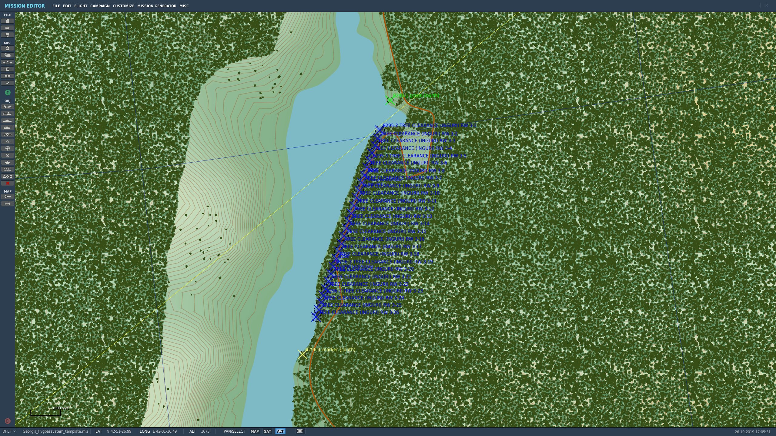
SCENERY REMOVE OBJECTS ZONE does not remove trees
Leviathan667 replied to Leviathan667's topic in Mission Editor Bugs
Find attached the mission file and a screenshot to the area where the problem lies most acutely. Even after fidgeting with the triggers and following the advice of MadDog-IC, the issue of the (non) removal of trees (but not other objects) is back. It did work once after I restarted the game. But now it does not help anymore. Thank you for your help in solving this issue. Georgia_flygbassystem_template.miz
-
SCENERY REMOVE OBJECTS ZONE does not remove trees
Leviathan667 replied to Leviathan667's topic in Mission Editor Bugs
Hi, It is on a Mission start trigger! -
SCENERY REMOVE OBJECTS ZONE does not remove trees
Leviathan667 replied to Leviathan667's topic in Mission Editor Bugs
I just played that same custom mission today and noticed it works on trees now... I did not change anyting in the conditions though. -
SCENERY REMOVE OBJECTS ZONE does not remove trees
Leviathan667 posted a topic in Mission Editor Bugs
I just noticed something seems to be broken in the mission editor (in DCS 2.5.5.38040). I am trying to set up road bases for the Viggen. So I have to remove trees and other objects (poles, street lighting) in the vicinity of the road runway. Removing objects works but not removing trees. Here's how I proceed: I create several a trigger areas on the portion of the road I want to use as a runway (width 150 ft each, side by side along the length of the runway). Set rules for trigger > In triggers, I create a new trigger and select: 1 ONCE, 2 I name it, 3 NO EVENT then I set no conditions then In ACTIONS: I select SCENERY REMOVE OBJECTS ZONE In Zone: I select a trigger zone I already created In Objects mask: I select All Thanks for your help -
Any good suggestions for a road base in the Caucasus map?
Leviathan667 replied to corvinus's topic in DCS: AJS37 Viggen
Thanks, will defintely try this one. Besides, I found another good spot to land in Georgia:the East-West road close to the town of Gorovani (N 41° 53' 15" E 44° 40' 20"). See video here: If anyone can help me put colourd smoking markers, I would appreciate as I rely on a big smoke with fire to mark the point where the landing area begings. -
Hi RagnarDa, When I take control of the plane in the replay, I cannot replicate your experiment. Maybe I am doing something wrong so let me lay down every step I'm going through In your track/my test flight, the following happens: 1. I take control 2. Switch to SPA (by default, this should be the SPA MAL mode) 3.T1 detent 4. Once above the ship > TV detent In your track: 4.1. The ship’s coordinates will show up on the data indicator to be replaced a few seconds later by 000000. How do you do it? The manual does not mention any such action. 4.2 After you stabilized the plane, LS then a yellow M1 appears on the destination indicator.How do you do it? The manual does not mention any such action. And is not the M1 indication supposed to be in red? 4.3 I guess this is where you press LS/SKU twice in rapid succession because S1 appears on the destination indicator. The S1 indication seems to be in red. Back to my test, nothing of the 4.1 to 4.3 steps happen. 5. I press LS/SKU twice in rapid succession to transfer to S1. Nothing happens. 6. I went back to NAV then back to SPA 7. Pressed B1 to select the first SPA fix point 8. Pressed LS/SKU in rapid succession to no perceptible effect. What's missing here? I also attached my track file below. Thank you for your help. AJS37 Recon LeviathanDemo.trk
-
*** FEATURE PREVIEW: MOBILE GROUND CREW ***
Leviathan667 replied to RagnarDa's topic in DCS: AJS37 Viggen
Thanks master QuiGon -
*** FEATURE PREVIEW: MOBILE GROUND CREW ***
Leviathan667 replied to RagnarDa's topic in DCS: AJS37 Viggen
Follow up question: is it possible to put a TILS beacon next to a road? -
*** FEATURE PREVIEW: MOBILE GROUND CREW ***
Leviathan667 replied to RagnarDa's topic in DCS: AJS37 Viggen
Has anyone tried to land on roads at night? I find it impossible after a few attempts. I use smokes with fire to mark the location of the road but it nos enough. There really is a need for full lighting along the portion of the road used for landing. Can I add the necessary lighting in the mission editor? -
GR. 1A with the ability to carry ALARM anti-radiation missiles & the B version with the capability to carry the Sea Eagle anti-ship missile
-
I forgot to mention the issues I reported were found on the OB version. I also posted videos to yourube show how the module behaves when those SPA features fail