.png.106163b2ff8ba3c8a044143ab5fd143e.png)
winghunter
-
Posts
741 -
Joined
-
Last visited
Content Type
Profiles
Forums
Events
Everything posted by winghunter
-
Thats true they wont switch their software stack. But my Quest runs on Android, yet i can play windows games. Theres also iTunes for windows. It all depends on apple's software integration plans.
-
Hmm not sure the "Pro" is really a consumer device. I think the main client base will be enterprise, professionals and some prosumers. Any company doing any sort of 3D, CAD, media will need a bunch of these. The XR3 may have some niche use cases, though imho the Pro will easily take the majority enterprise share. The "Apple Vision Air" may be the consumer version
-
Apple Vision Pro beats the Varjo XR-3, and with its price point of $3500 at half the price.
-
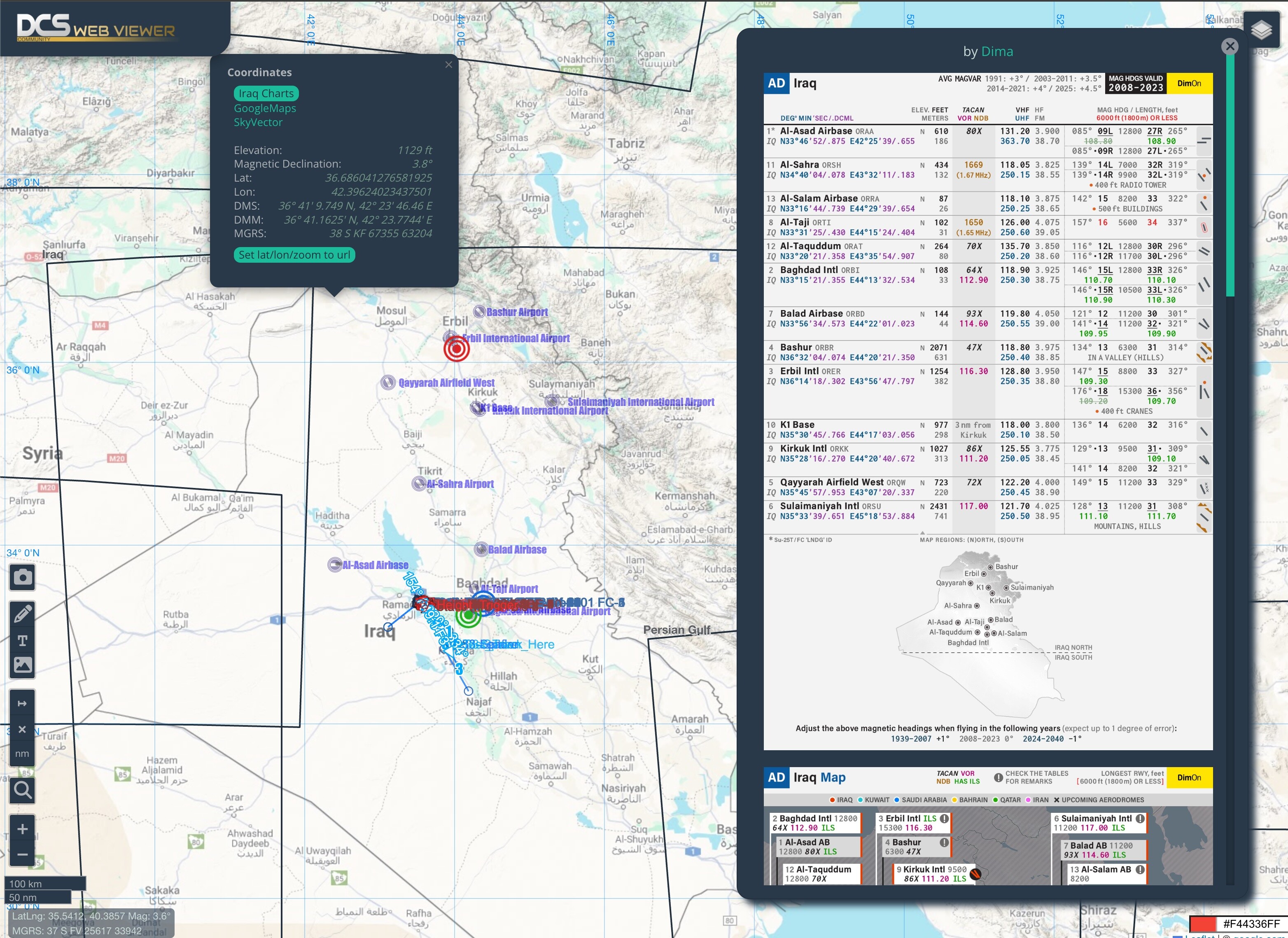
.thumb.png.d43db0aa51621a39a2161ec5c6fff372.png) Thanks. I hope ED is already working on SEA. Otherwise we will build it as a community at some point. You can load a mission file directly from DCS User Files using the Load remote mission button. And for example you can go directly to Unit#85 by adding &unitId=85 to the url. Or you can go to specific lat lon coordinates. This is useful for embedding into iframes or for showing problems in your mission to other users i.e. Go to unit 85 https://dcs-web-editor.github.io/dcs-web-viewer-deploy/?load=https%3A%2F%2Ffiles.digitalcombatsimulator.com%2Fuserfiles%2F95f%2F90t4yjdxqwx485v38n4ge8er7bk7m0z9%2FF16_RNLAF_ISIS_Base_160129_NoMods.miz&zoom=17&unitId=85 Go to lat lon zoom: https://dcs-web-editor.github.io/dcs-web-viewer-deploy/?load=https%3A%2F%2Ffiles.digitalcombatsimulator.com%2Fuserfiles%2F95f%2F90t4yjdxqwx485v38n4ge8er7bk7m0z9%2FF16_RNLAF_ISIS_Base_160129_NoMods.miz&zoom=17&lat=36.951397233614&lon=37.464512889798# Go to line 75 in mission.lua script https://dcs-web-editor.github.io/dcs-web-viewer-deploy/?load=https%3A%2F%2Ffiles.digitalcombatsimulator.com%2Fuserfiles%2F95f%2F90t4yjdxqwx485v38n4ge8er7bk7m0z9%2FF16_RNLAF_ISIS_Base_160129_NoMods.miz&zoom=17&lat=36.951397233614&lon=37.464512889798&line=75
Thanks. I hope ED is already working on SEA. Otherwise we will build it as a community at some point. You can load a mission file directly from DCS User Files using the Load remote mission button. And for example you can go directly to Unit#85 by adding &unitId=85 to the url. Or you can go to specific lat lon coordinates. This is useful for embedding into iframes or for showing problems in your mission to other users i.e. Go to unit 85 https://dcs-web-editor.github.io/dcs-web-viewer-deploy/?load=https%3A%2F%2Ffiles.digitalcombatsimulator.com%2Fuserfiles%2F95f%2F90t4yjdxqwx485v38n4ge8er7bk7m0z9%2FF16_RNLAF_ISIS_Base_160129_NoMods.miz&zoom=17&unitId=85 Go to lat lon zoom: https://dcs-web-editor.github.io/dcs-web-viewer-deploy/?load=https%3A%2F%2Ffiles.digitalcombatsimulator.com%2Fuserfiles%2F95f%2F90t4yjdxqwx485v38n4ge8er7bk7m0z9%2FF16_RNLAF_ISIS_Base_160129_NoMods.miz&zoom=17&lat=36.951397233614&lon=37.464512889798# Go to line 75 in mission.lua script https://dcs-web-editor.github.io/dcs-web-viewer-deploy/?load=https%3A%2F%2Ffiles.digitalcombatsimulator.com%2Fuserfiles%2F95f%2F90t4yjdxqwx485v38n4ge8er7bk7m0z9%2FF16_RNLAF_ISIS_Base_160129_NoMods.miz&zoom=17&lat=36.951397233614&lon=37.464512889798&line=75 -
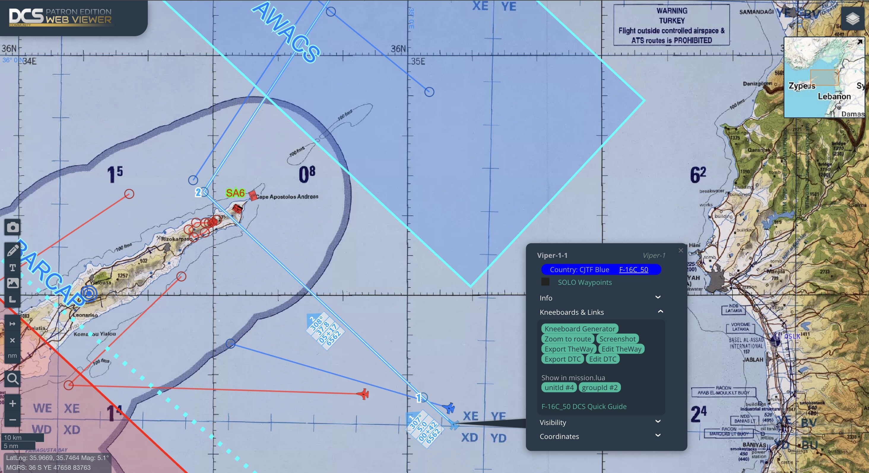
Open and plan DCS missions in your browser. Export flight paths, create nav charts, logs and more... Export kneeboard charts to PDF and PNG Export TheWay and DTC files Accurate DCS magnetic/true headings for latitude, longitude and mission time KML / KMZ support Embed in your website, i.e.https://www.v303rdfightergroup.com/index.php?pages/afghanistan_navaids/ Also checkout DCS Web Editor and DCS Web Miz DCS Web Viewer ( free edition )

-
TLDW * Its the best headset from Pimax * Quite heavy - 1.2 kg * Head straps break * Some units ship with plastic lenses, to be replaced later * Exchangeable lens system seems like a gimmick * People receive different versions of the cable / copper vs fiber optic * Resolution and brightness are really good * Local dimming is difficult to get working, and causes some blooming * No games seem to be running above 90Hz currently, despite showing 120Hz * Controller tracking is ok, not great * Glass lenses have some chromatic aberration * Headset may work best for stationary simulators, but not for motion based games due to weight and tracking
-
If ED isn't doing it, at some point we will
-
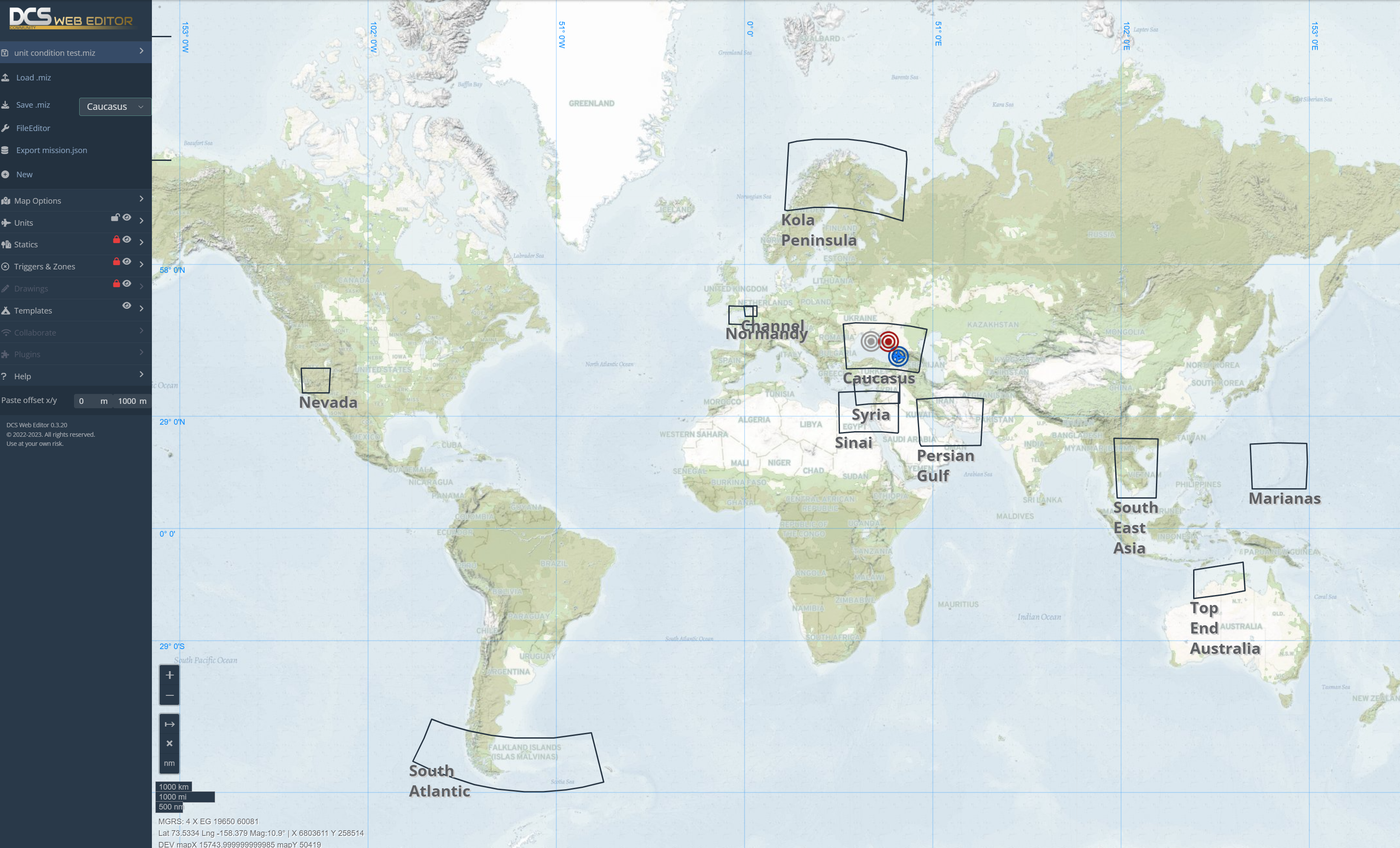
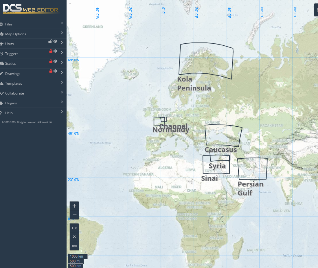
Coordinates of released maps are exported straight from DCS. Caucasus is one of the largest maps ( even though its mostly low detail area). Note that in this Mercator projection, land masses towards north and south pole appear bigger than they are. Hence Kola and SA maps also appearing larger.
-
DCS running natively on the M2 isnt going to happen in this decade. So it would have to be streamed over WIFI which should be certainly possible with various 3rd party apps.
-
Maybe these settings help
-
At 10:10 theres "Smart Smoothing" which sounds like MR from the description, aka frame interpolation
-
DCS Web Miz - browser based mission file editor
winghunter replied to winghunter's topic in Mission Editor
The previous update broke the functionalty. It should be fixed now https://dcs-web-editor.github.io/dcs-web-editor-mono/
-
I think MR in the Crystal is broken or non existant at this point. Which is a major downside of this headset. Theres not even a time line for MR as far as i can see, and you cant really trust pixmax timelines anyhow.
-
To be fair, he also said:
-
Crystal vs Aero Pros and cons of both headsets, seems pretty fair
-
What is "unit.psi" and why is it screwing up a spawned unit's heading?
winghunter replied to cfrag's topic in Mission Editor
Hmm so these are the Euler angles ψ psi – heading θ theta – pitch angle Φ phi – bank angle The reason "psi = - heading" may be due to the coordinate system. -
What is "unit.psi" and why is it screwing up a spawned unit's heading?
winghunter replied to cfrag's topic in Mission Editor
I have the same issue, and found this local function setUnitStartParameters(unit) if unit.boss then local route = unit.boss.route if route then local p1 = route.points[1] if p1 then unit.speed = p1.speed unit.alt = p1.alt unit.alt_type = p1.alt_type if p1.type.action == 'From Ground Area' or p1.type.action == 'From Ground Area Hot' then unit.psi = -unit.heading else local p2 = route.points[2] if p2 then unit.psi = math.atan2(-(p2.y - p1.y), p2.x - p1.x) end end end end end end -
At least flight sim guy has shared quite a lot of critique of the initial Pimax Crystal setup ( in another video). Its not a smooth experience compared to Varjo or Reverb
-
Another DCS + Crystal test
-
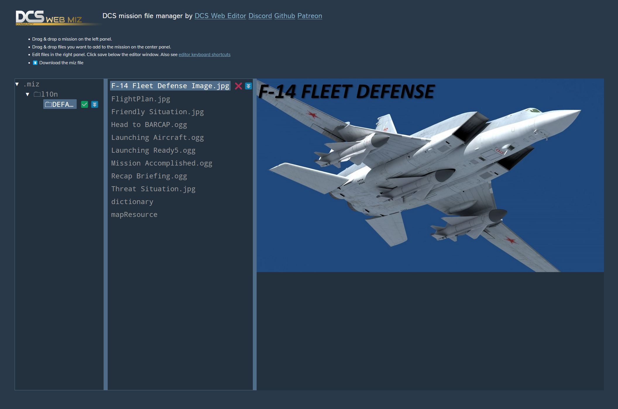
how to extract audio files from the miz file
winghunter replied to hjd1985's topic in Mission Editor
Or use DCS Web Miz https://dcs-web-editor.github.io/dcs-web-editor-mono/ -
That Web Based Mission Editor I saw in a (fake/real?) video...
winghunter replied to cfrag's topic in Mission Editor
The miz file manager is already released, the viewer is in beta and the editor is in alpha -
Are the official coordinates already known ?
winghunter replied to winghunter's topic in DCS: Normandy 2.0
These estimates were posted by Razor: Razor — Yesterday at 23:04 East boundary about E03°14'31'' West boundary about W03°28'34'' Northern boundary about N51°44'45'' Southern boundary about N48°26'35'' N, E and W coordinates taken from videos with the mouse cursor at the edge of the map S coordinates taken from google maps based on the most southern airfield on the map -
Are the official coordinates already known ?
winghunter replied to winghunter's topic in DCS: Normandy 2.0
I have seen this map, but i cant find the exact lat/lon coordinates ? -
I would like to add support for Normandy 2.0 in DCS Web Viewer and DCS Web Editor. Thanks
-
Sebastian tested DCS in the pimax crystal