shagrat
-
Posts
13380 -
Joined
-
Last visited
-
Days Won
6
Content Type
Profiles
Forums
Events
Everything posted by shagrat
-
Es wurde klar und deutlich vom "DCS"-Ordner IM "Saved Games"-Verzeichnis gesprochen. Niemand hat davon geredet, das gesamte "Saved Games"-Verzeichnis zu sichern / zu kopieren. Es geht ja um DCS verschieben / kopieren und nicht um evtl. die Spielstände und Konfigurationsdateien dutzender anderer Spiele in "Saved Games". Und wie schon erwähnt: verschiebt man aus Platzmangel, das gesamte "Saved Games"-Verzeichnis, sollte dies über Rechtsklick auf den "Saved Games"-Ordner im Explorer und dann "Eigenschaften" getan werden. So werden alle Systemrelevanten Verweise ebenfalls angepasst.
-
Sollte auch niemand. Btw. egal wo der "Saved Games" Ordner liegt, oder hin verschoben wurde, wenn es richtig gemacht wurde, also über Properties des Folders, verweist die Systemvariable ohne rumfummeln auf den korrekten Ordner. Beim neu installierten Windows, ist "Saved Games" dann eh default auf "C:" oder man verschiebt ihn wieder per Properties.
-
Nein. Ziemlich sicher die hier (ersten ausgelieferten C-130J). 55+02 https://de.m.wikipedia.org/wiki/Datei:Hannover_Airport_Luftwaffe_German_Air_Force_Lockheed_Martin_C-130J-30_Hercules_55%2B02_(DSC01156).jpg
-
That was exactly my intention. Do not waste $$$ on a clutch/friction based "AddOn", focus on the extension, as it is a big help to get a more "real" feel. Save for FFB, if the goal is a more realistic control, that's close to how a real helicopter with hydraulics "feel". I am sure one can even use a voice commanded Raspberry Pi to "perfectly fly a helicopter in DCS", with some training, but the idea in general is to "closely simulate" the controls, in a simulation. While a centering spring in a simulated jet aircraft is "ok", in a helicopter it's not even remotely, what pilots in real helicopters have, apart from the look, maybe. On the other hand, you can if course start with a normal stick and DCS trimmer modes and learn to proficiently fly a helo in DCS. An FFB base for the cyclic doesn't magically make you a trained helicopter pilot, but coming all the way from a Logitech 3D extreme, through X-52, Warthog, Virpil stuff to the Rhino, in my opinion, if you intend to focus on helicopters in DCS and stick to the hobby it is well worth to save for a FFB base and skip a couple controller iterations in-between.
-
If you plan to deep dive into helicopters in DCS, I recommend to prioritize the extension, then safe for a FFB base. I know it's expensive, but along the natural and realistic force trim and hydraulic feel, you get force feedback for telemetry events... or in layman's terms, you can feel the stick shaking if you get through transitional lift, or the onset of a vortex ring state, before it occurs, a bump on touchdown, the blades actually spinning, weapons firing and other stuff. It is definitely a game changer and with now 4 good bases in the pipeline, I wouldn't bother with investing in a clutch/friction based solution, if it's not already integrated. Just my personal opinion, but I did go through the whole path of equipment over the last decades and would skip some steps, if I had to do it again.
-
Nope, totally different beast. You want a Force-Feedback (FFB) base, like the VPForce Rhino, or the Moza copy of it. Winwing is going to release a different, but looking very promising FFB design, of their own. Virpil has a FFB-base planned. If your current base has friction ( as in tension screws that add friction, and can hold the stick in place) your best bet for now is removing as much centering force as possible and tighten the tension, so the stick can be moved, but stays in place when left alone. Use this with trimmer settings "for Force-Feedback/No Spring" in DCS! Anyway an extension, 15-20cm is highly recommended for helicopters, it gives you way more granular control per degree of movement on the stick axis which makes the little adjustments much easier.
-
...to prevent this.

-
Was mir spontan so einfällt: Datenschutz und Verarbeitung von Telemetrie und Diagnosedaten unklar. Die Diskussion um die Implementierung von "Recall". Features wie Defender for Endpoints Timeline. Integrierte Werbung, die man erst abschalten muss. MS Account-Zwang, den man umständlich "umgehen" muss, um sein OS benutzen zu können, falls etwas mit dem Account "schief läuft". Rechtsklick-Menü versteckt "fremde" App-Integration. Kann man natürlich nicht umstellen. Startmenü noch unbenutzbarer, als das dysfunktionale von Windows 10. Gerätemanager nur noch über Umwege, aufrufbar. Und generell mehr sinnlose Klicks durch Menüs, um an Settings zu kommen.
-
Schau am besten mal in die aktualisierte Anleitung, es gibt einige Neuerungen bei George. Ist i jedem Fall in der Englischen Anleitung beschrieben, wie bspw. die neuen Scan modes funktionieren.
-

investigating mk82, 83 bombs explosion radius too large after update?
shagrat replied to SalakauHeadman's topic in Weapon Bugs
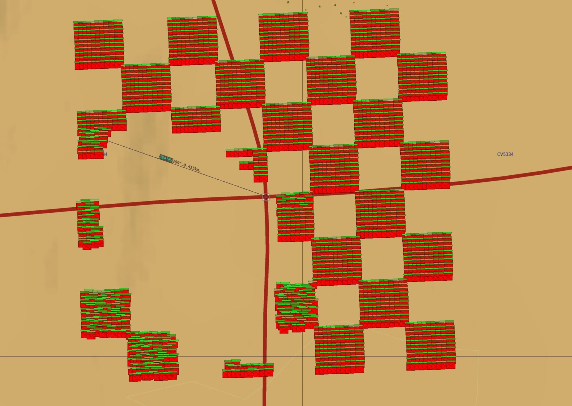
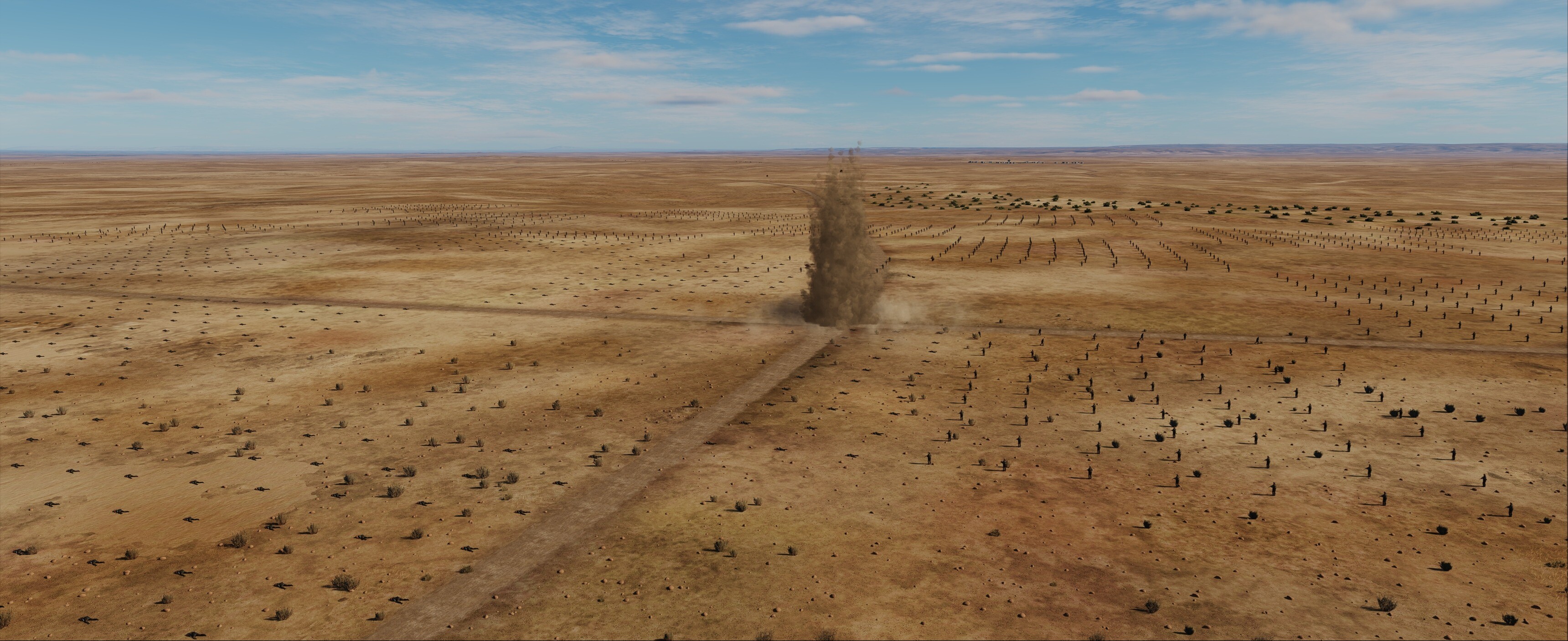
The thing is a metal fragment lodged in your torso won't necessarily "kill" you, but rest assured, you won't be combat effective either. In DCS there is no "incapacitated, but not dead" state, only shooting back unphased, or dead. Interestingly DCS models LOS, so a Mk82 can be survived by Infantry as long as they are situated in cover behind a small ridge or in a ditch. Again, the danger areas are ok, the problem is with blast damage being evenly applied to ALL units in that area with LOS to the epicenter of the explosion. The damage radius is "Ok" (420m currently, from my tests), but the damage is applied to all units and not to the RED percentage. But terrain elevation will shield even infantry in close proximity (see screenshots). The whole checkers quare of soldiers is 1,000m x 1,000m and the bomb impact is on the crossroads in the center. The street N-S is slightly elevated, so is the berm to the north on the western side (shields the troops against the blast). F10 View after impact: In game view:null
-
mk82, 83 bombs explosion radius too large after update?
shagrat replied to SalakauHeadman's topic in Weapon Bugs
Correct, but they "can" incapacitate someone within 425m, through fragmentation. The current issue is that blast does damage to all objects inside the blast distance, instead of only a certain percentage. The biggest issue I see currently is, that bombs trigger other bombs in the air through blast damage. This definitely needs adjustment. But the correct approach is to adjust the damage dealt and set distance thresholds for bombs being triggered. Not reverting back to the old damage model where a bomb designed to level a couple buildings barely scratched some vehicles 50m from the impact... As for the concept of Risk Estimate Distances, we need to learn that RED with a PI 10 of 250 meters means you do NOT drop a live Mk-82 bomb closer than 250m to friendly forces and expect no blue on blue casualties, at least in real life. You may drop danger close (inside PI 0.1), if the ground commander takes the responsibility and accepts potential harm to his soldiers or civilians, but that's still a certain risk many NATO countries wouldn't accept... -
Seeing Mossul mentioned, did the team have time to add some landmarks in the coming update? Asking for a friend... https://forum.dcs.world/topic/371325-details-and-landmarks-in-mosul/#comment-5630236
-
mk82, 83 bombs explosion radius too large after update?
shagrat replied to SalakauHeadman's topic in Weapon Bugs
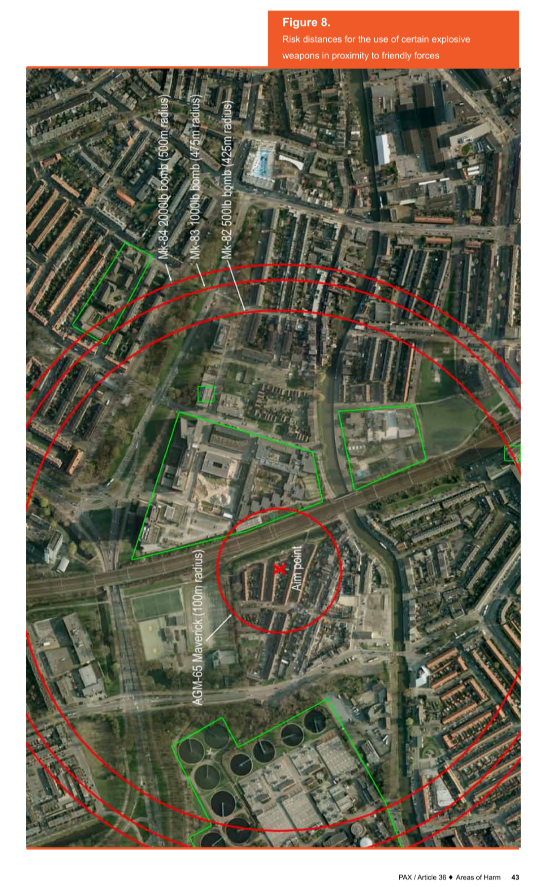
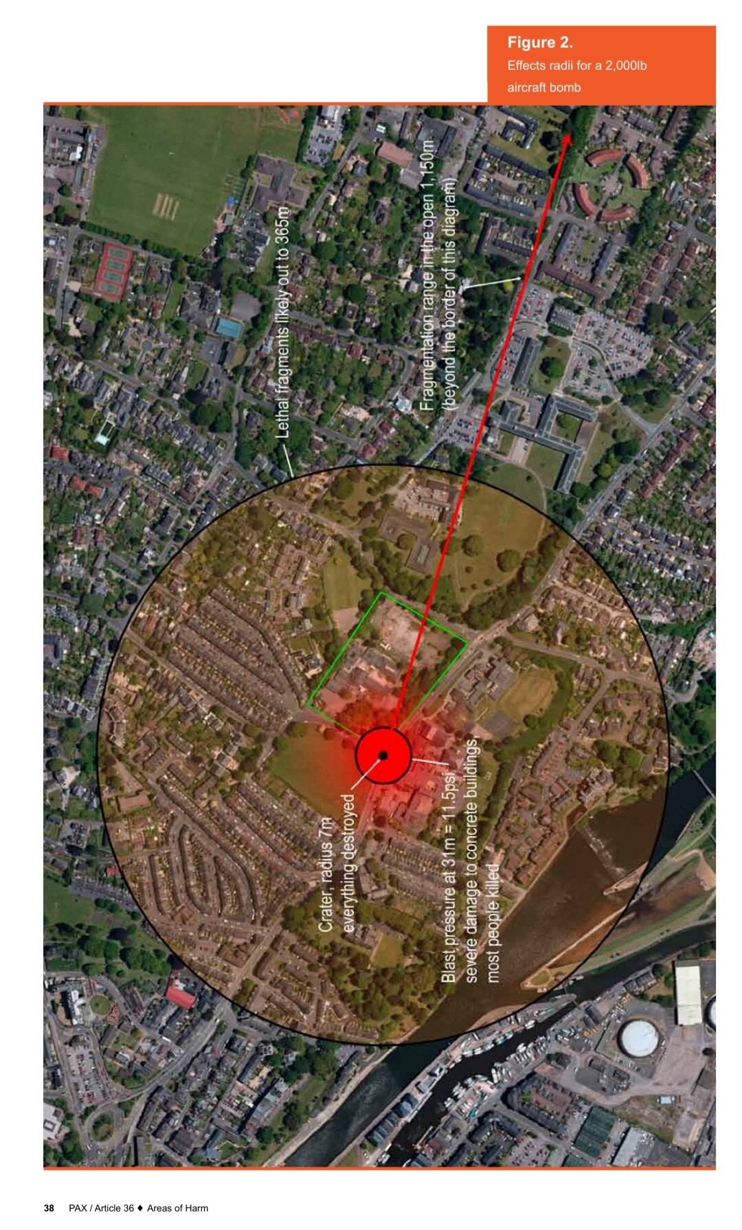
Maybe this visualization helps to better grasp what 425 m of "danger close" to friendly forces actually means. First picture represents a Mk-84 (2.000 lbs) bomb and shows the difference between the direct effects and the fragmentation radius "in the open". The second shows a comparison between the Risk Estimate Distances area. Note the 100m RED of the AGM-65 Maverick in the center, in comparison to the Mk 80 series bombs. Source is this article, PDF direct link: https://article36.org/wp-content/uploads/2016/10/PAX-A36-Areas-of-Harm.pdf
-
mk82, 83 bombs explosion radius too large after update?
shagrat replied to SalakauHeadman's topic in Weapon Bugs
It's how a 500 lbs bomb works in real life. That's the reason why those special low yield weapons for CAS employment were developed in the War on Terror with the aim to minimize collateral damage. They even used training bombs (casings filled with concrete) to minimize damage to civilian infrastructure and innocent bystanders. Keep in mind the damage radius is ok, the time for fragmentation to reach the full distance will be slower than the current blast damage, but it will still incapacitate a couple people if fragmentation simulation is implemented later. Unfortunately blast is "hitting" every unit in the RED currently. So now we need to make the same tough decisions for CAS and choose appropriate weapons in danger close scenarios, as finally the "danger" in danger close is real... not ridiculous. -
Analoge Uhr (Ziffernblatt) nicht, aber eine im IFEI unten rechts und mit TIMEUFC unten auf der HSI Page kann man eine im HUD einblenden lassen.
-
That's not addressing the issue. The problem is if you command any search, AI George will find the yellow "Unknown" outpost or workshop you added to a FARP in 25 km distance, while you want him to find the red infantry you currently look at that's lobbing tracers and RPGs at the blue MRAPs 4 km directly in front of you! The list now shows a couple yellow buildings in the distance and nothing else, so you have George scan for targets again, and again and again, only to get the same yellow buildings from the FARP now 20 km away, while you get too close for comfort to the AAA and infantry still directly in front of you. Even if you adjust the list display to Hostile & Unknown only, the far away and out of weapons range unknown outpost, is still clogging the target list. Now, with the new scan PHS Zone, why is George listing unknown targets 20-25 km away, if I clearly look at an orchard 3.5 km in front? If we had an option to force the AI (like telling our CP/G in real life) to only report HOSTILE (red) targets and ignore neutral, blue and unknown, especially out of weapons range(!) for building the target list, that would be great.
-
Solange du keine großen Dateien (50GB+) kopierst, speicherst oder viele (200+) kleine Dateien in einem Rutsch kopierst oder entpackst solltest es kein Problem geben. ...und das nächste Problem, diesmal inklusive Windows 10. (...)Streaming-Chaos nach Windows-Update Betroffen sind Nutzer nach dem Update auf KB5063878 (Windows 11 24H2) oder KB5063709 (Windows 10 22H2), die ein Network Device Interface (NDI) zum Übertragen von Audio- und Video-Feeds zwischen Computern verwenden. Die Probleme zeigen sich besonders deutlich in beliebten Streaming-Anwendungen wie Open Broadcaster Software (OBS) und NDI Tools. Nutzer berichten von Rucklern, erheblichen Verzögerungen und abgehackter Wiedergabe, selbst bei geringer Bandbreite. Die Auswirkungen werden besonders deutlich, wenn die "Display Capture"-Funktion aktiviert ist, die viele Streamer nutzen. Microsoft bestätigt NDI-Regression. Microsoft hat das Problem offiziell bestätigt und erklärt in einem Beitrag im Release Health Dashboard, dass die fehlerhafte Interaktion auftritt, wenn NDI für seinen Standard-Empfangsmodus konfiguriert ist.(...) Quelle: https://vmod.info/forum/index.php?thread/8922-windows-11-patch-day-übergangslösung-für-streaming-bug-gestartet/
-
Das Problem tritt bei allen Quellen nach der Installation des KB5063878 bzw. bei Beta Testern durch KB5062660 auf. Und das ist nur für Windows 11. Das letzte reguläre Update für Windows 10 war Out-Of-Band KB5066188, am 19.August, zum beheben des Recovery Mode Bugs aus dem letzten Security Patch von vorletzter Woche (12. August).
-
mk82, 83 bombs explosion radius too large after update?
shagrat replied to SalakauHeadman's topic in Weapon Bugs
Yep, blast range is ok now, but the damage dealt over distance is A) a bit too excessive (my subjective opinion) and B) as it is a stand in for fragmentation too fast, as the fragments slow down faster. Keep in mind, if you dropped more than one bomb the damage is cumulative (also in real life), as the blast waves overlap (and IRL would interact). Also IRL an airburst Mk-82 would spray the whole site and damage most if not everything not armored. The thing here is damage modeling, though it has improved, isn't able to visualize things like crew incapacitated, a track of a tank damaged (mobility), though some effects are modeled. For example damaged units can't drive full speed any more, simulation of engine/mobility damage. So, yes, the current change is not perfect, but it is a big step in the right direction. For a long time, you could more or less throw a Mk-82 between a couple T-80 some 10m apart and if you were very lucky one got noticable damage. IRL the crews would have been heavily disoriented, or even injured, likely the tracks on the side of the explosion damaged and some of the optics and external weapons (DshK) damaged. -
mk82, 83 bombs explosion radius too large after update?
shagrat replied to SalakauHeadman's topic in Weapon Bugs
Yep, that's pretty accurate. 150m is less than half the 425m RED. So the fragmentation should incapacitate/render the majority of the site unusable, at least you would need to fix a lot of damage. As I pointed out above, currently the fragmentation is "faked" by blast damage, which is not perfect. Blast wave travels faster than fragmentation does. But actually DCS bomb damage felt like a joke, compared to real life, before. The adjustment definitely needs fine tuning, fragmentation calculated and in a perfect world even blast wave accumulation and reflection on objects, including over- and underpressure effects, but at least we now have bombs that can destroy/collapse buildings and do damage to vehicles without a direct hit! I am not sure if it's still linked on the GICHD site, but there was a nice damage area and damage distribution simulation linked, where you could see the distances on a simulated village. Also the document I linked, is really worth reading, especially the part of damage and casualty rates in urban areas (as secondary fragmentation increases the actual damage to people and unarmored/light armored vehicles). At least I hope there's an interest in understanding the real life effects and distances, with exactly the problems for weapon employment under ROE, which led to the development of low collateral damage weapons like the BLU-39 or BLU-129/B. -
mk82, 83 bombs explosion radius too large after update?
shagrat replied to SalakauHeadman's topic in Weapon Bugs
Wanna try? Open ground, no cover. I wouldn't recommend it! Even with eye protection, helmet and body armor... real life is different than computer games. -
mk82, 83 bombs explosion radius too large after update?
shagrat replied to SalakauHeadman's topic in Weapon Bugs
Also, there were modifications to the actual bomb body, that aimed at improving the fragmentation damage and radius. Like pre-fragmented casings, optimized materials and air-burst fuzes. In the recent conflicts the requirement changed toward less, but precise damage. Though typically that was addressed by separate low yield or kinetic weapons. I mentioned it in an earlier post, in DCS the difficulty is currently to balance the lack of fragmentation modeling with the effects of blast damage. Blast damage naturally travels faster than fragments. So the new adjusted blast radius is a stand in for fragmentation, which in itself is a step in the right direction and very much appreciated (finally a bomb, rather than a glorified handgrenade). On the downside, the danger to low flying aircraft is calculated by the fragmentation pattern over time, so with the blast reaching a low flying aircraft, way faster than the fragments would, we need to delay the bombs fuze in a HD low altitude attack, so we clear the excessive blast range faster. But we need to be aware, a friendly ground unit or helicopter inside the RED is not "safe". The "Danger Close" definition, is friendlies inside the 0.1 PI RED... and that's 425 m according to the GICHD document and other sources. If we assume it is a good idea to have cleared the airspace inside a 450 m radius around the impact point before(!) the bomb explodes, we should be safe. -
mk82, 83 bombs explosion radius too large after update?
shagrat replied to SalakauHeadman's topic in Weapon Bugs
...ever thrown a hand grenade IRL? -
It's not necessarily the money, but the lack of qualified specialists in both programming and aviation including physics, that need to learn an unfamiliar development environment first... and if they exist they maybe already in a contract with aviation industry, military or both, which may or may not result in a conflict of interest, that prevent side-gigs at another developer.
-
No, I am aware of the process, typical timeline and do good expectation management. Or simply put, you might not be cut out for Early Access products, as your expectations mismatch greatly with reality.