phant
-
Posts
6479 -
Joined
-
Last visited
Content Type
Profiles
Forums
Events
Everything posted by phant
-
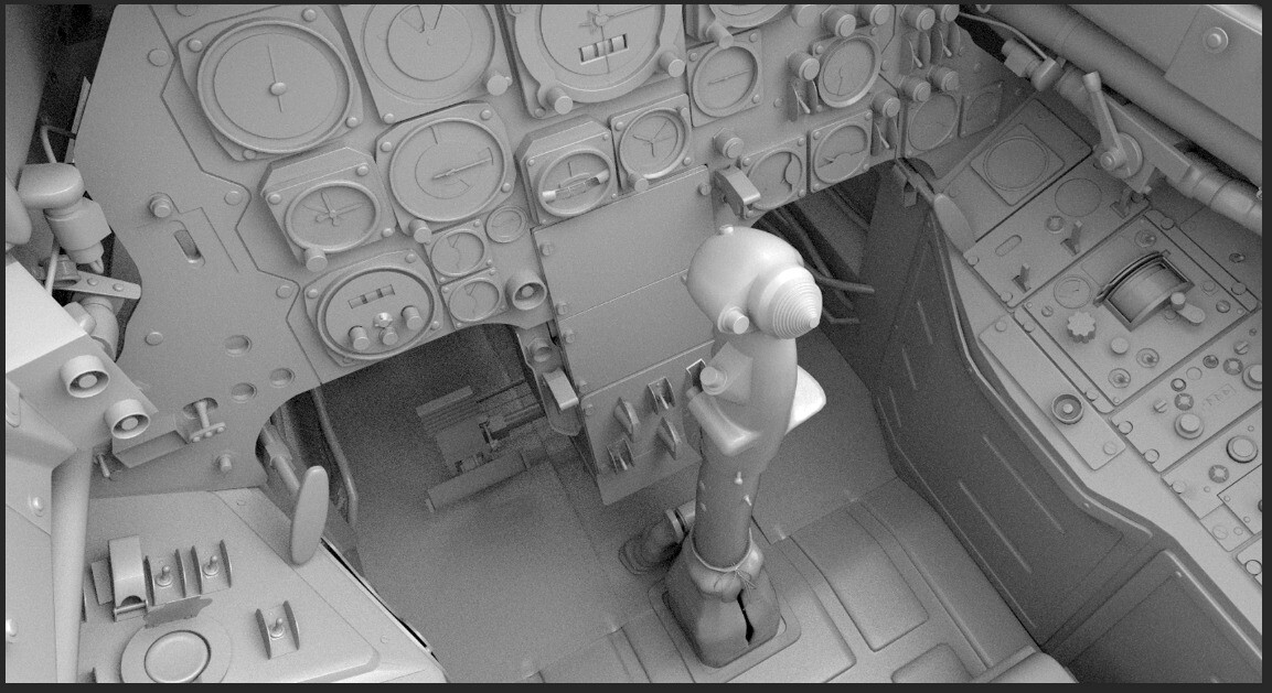
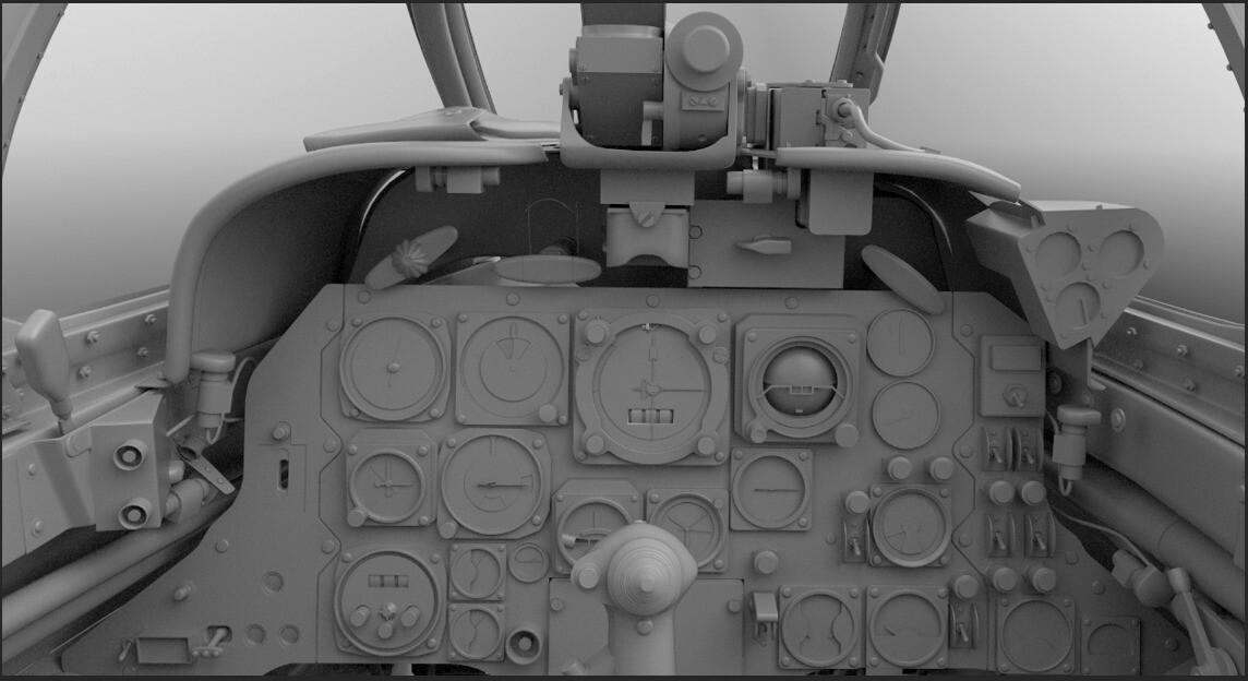
DCS PROJECTS UPDATE Given that the latest modules released on DCS have raised the bar in terms of both graphical quality, fidelity and available features, in the past few weeks we conducted a thorough analysis of this project and reassessed its current quality goals. We found that it was not on par with the new targets, and therefore we have decided to vastly rework the project. We have reviewed once again alll our source material, including all the photographic surveys taken in various museums and we believe we have vastly improved the 3D models, adding and improving several small details. We have also decided to rework all the the textures, in order to achieve a more realistic and lived-in appearance. Bye Phant

-
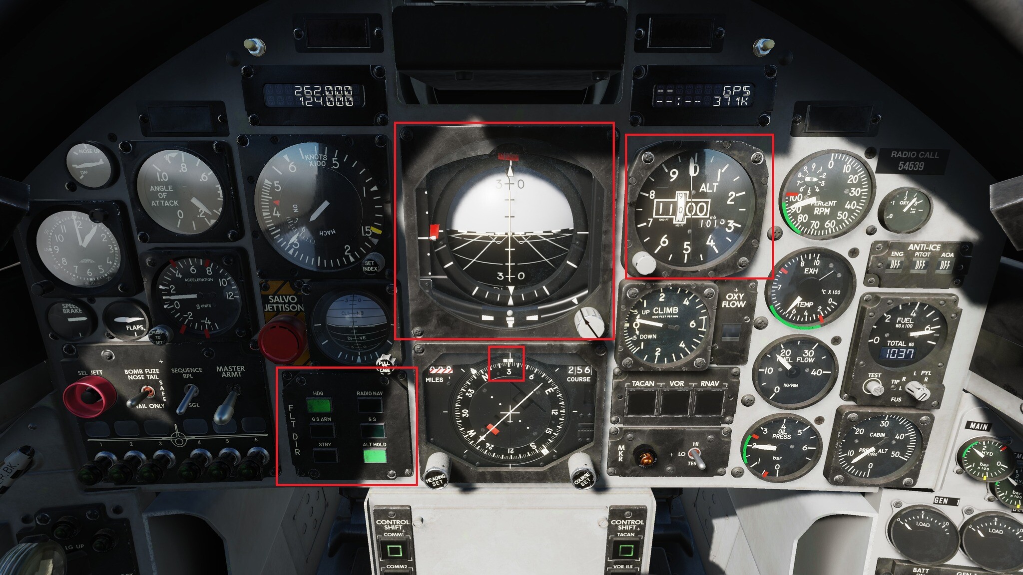
DCS PROJECTS UPDATE The upcoming DCS: MB-339 update will include the long-awaited flight director, which will assist the pilot during instrument flight. Unlike the flight director implemented in the MSFS version, which relies on the use of proportional coefficients and provide approximate indications, the DCS version will deliver a more accurate experience as it is based on a PID (Proportional, Integral, Derivative) control system. The flight director is undergoing fine-tuning of the PID coefficients and testing and will be madereleased as soon as the testing is complete. Bye Phant
-
Bye Phant
- 181 replies
-
- 2
-

-

-
- f-4e
- phantom ii
- (and 1 more)
-
Bye Phant
- 181 replies
-
- 2
-
-
-
- f-4e
- phantom ii
- (and 1 more)
-
F-4E Phantom II We are delighted to share that the DCS: F-4E Phantom II by Heatblur Simulations is slated for early access release on the 21st of May at 15:00 GMT, 2024. If you have not already seen it, don’t miss the F-4E release announcement video, you will be impressed! Hurry, time is running short to secure your -25% discount by pre-ordering now. The much anticipated launch of the Phantom II is just around the corner. Renowned for its capabilities as a highly effective and versatile fighter-bomber, this iconic jet excels in both air-to-air combat and ground attack missions using a wide array of munitions. With Heatblur’s dedication to ultra-realistic simulation, you can expect meticulous attention to detail from cockpit graphics to the flight model. More details will be unveiled soon. Bye Phant
-
Operation Green Line Campaign by Badger633 This immersive campaign features 12 unique missions that are interconnected through a continuous narrative across multiple Middle Eastern locations. Both carrier and land-based operations are included. Developed with virtual reality in mind, the campaign eliminates the need for jotting down transient coordinates, thereby maintaining immersion. Optional tanker refuelling is available, though careful fuel management can negate its necessity. The campaign includes over 1,700 voice-overs, a 'Speed Stop' feature to prevent missing content during time acceleration, and adjustable AI settings for the final four missions to suit different skill levels. Each mission comes with detailed briefings that are accessible in-game and as downloadable PDFs. Customised aircraft skins are included to enhance the personalisation of the gameplay experience. Bye Phant
-
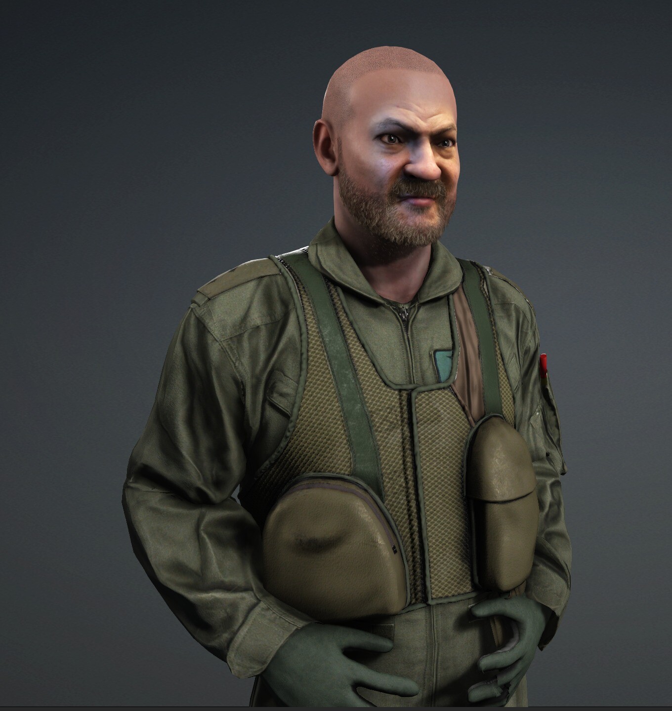
3D Pilot Models Development Report Bye Phant
-
Bye Phant
-
Dear DCS Simmers, Today we successfully completed the downwash effect for the Medusa rotor system. All 10 sectors of each rotor blade are included and the distance to the ground is accurately calculated. The first tests were very(!) successful. Next, the ground effect is connected to the MEDUSA rotor system. Air density, temperature, rotor speed, parts on the helicopter and other physical influences are taken into account here. GYROS: Gyro alignment is currently limited from 2 minutes to 10 seconds. However, we will implement a feature in the configuration menu that can be selected between REAL ALIGNMENT and FAST ALIGNMENT. TEST PHASE: We have programmed an extra app for the RL PILOTS that runs during the flight and allows them to influence the intensity of all control inputs during the flight. This app has sliders that are taken over in real time by DCS and are executed directly. Final Tasks for FM: - LUBRICATION - HYDRAULIC - ENGINE (This task will be finalized as soon as we have the inputs from the FM test from the RL pilots) Our Pilot already entered the Cockpit...ROIE, our Co-Pilot is ready ... FONTE https://www.facebook.com/permalink.php?story_fbid=122101009736312022&id=61559360667659&ref=embed_post Bye Phant
-
FONTE https://forum.dcs.world/topic/97330-dcs ... nt=5431081 Bye Phant
-
Bye Phant
-
Bye Phant
- 181 replies
-
- 1
-
-
- f-4e
- phantom ii
- (and 1 more)
-
Bye Phant
-
Bye Phant
-
Bye Phant
-
DCS Kola Map FAQs Bye Phant
-
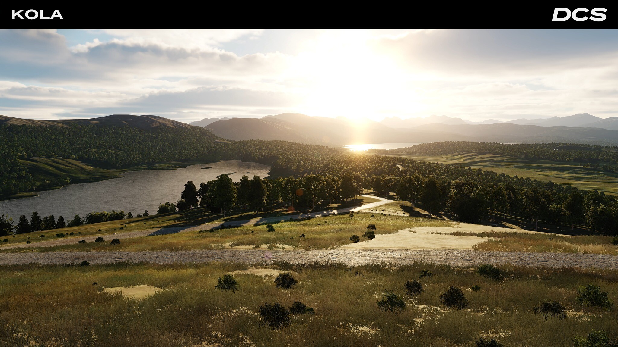
Kola map by Orbx Systems Early access Orbx is pleased to announce that its DCS: Kola map is now available in early access. The map covers northern Norway, Sweden, Finland, and the Russian Murmansk Oblast and parts of the Karelia region. It also includes large areas of the Barents Sea and Norwegian Sea to the north and west, ideal for aircraft carrier operations. The DCS: Kola early access release is offered with a special 20% discount ($55.99 USD), for a limited time whilst the Orbx team work to expand the content, detail, number of air bases, cities, towns, villages and infrastructure. The map price may also increase accordingly, so make sure you secure your discounted version now. The early-access release of DCS: Kola focuses on a large area that spans the Finland/Russia border and encompasses, central Finland and the western parts of the Murmansk and Karelia regions of Russia (see map). Within that subregion are several higher detailed areas, centered on airports in Finland (Rovaniemi, Kemi Tornio plus two road airbases), and Russia (Olenegorsk, Severomorsk 1, Severomorsk 3, Monchegorsk, and Murmansk International), and their urban and rural surroundings and infrastructure. Outside of this focus area, two airports in Norway (Bodo and Laksekv) and three in Sweden (Kalixfors, Kiruna, and Jokkmokk) are functional but not fully detailed yet. Bye Phant
-
DCS 2.9.4.53990 Bye Phant
-
DCS: Kola map will soon be available for early access The early access DCS: Kola map covers northern Norway, Sweden, Finland, the Russian Murmansk Oblast, and parts of the Karelia region. It also includes large areas of the Barents Sea and Norwegian Sea to the north and west, ideal for aircraft carrier operations. This area contains several high-detail locations, centered on airports in Finland (EFRO, EFKE, plus two road airbases), and Russia (XLMV, ULAK, RU-1110, RU-4464, ULMM), along with their urban and rural surroundings and infrastructure. Outside this focus area, two airports in Norway (ENBO, ENNA) and three in Sweden (ESNQ, ESNJ, ESUK) are functional but not fully detailed yet. The Orbx team has made every effort to craft a map that can be enjoyed by all types of users and will continue to update the map with additional content including airports, military installations, natural features, and lots more POIs over the following months. The team will also work on enhancing ground textures to reach a “real-life” level of detail as much as possible. The early access release comes with a special 20% discount, priced at (USD 55.99), but only for a limited time. As the map evolves with further content the purchase price may also increase. Here are the key features you can expect from the Early Access release: Complete base terrain for the entire map area, with highly detailed topography, summer ground textures summer, shorelines, and lakes and rivers. An initial focus area spans the Finland/Russia border and encompasses central Finland and the western parts of the Murmansk and Karelia regions of Russia (see map). Four high-detail areas, focusing on two airports in Finland (EFRO, EFKE) and five in Russia (XLMV, ULAK, RU-1110, RU-4464, ULMM), and their urban and rural surroundings and infrastructure. Two road runways in Finland, near Rovaniemi and Sodankylä, respectively. Two additional airports in Norway (ENBO, ENNA) and three in Sweden (ESNQ, ESNJ, ESUK) are functional but not fully detailed at early-access release. Significant civilian POIs include bridges, vertical obstructions, monuments, hydro dams, power stations, port facilities, landmark buildings, open-pit mines, towns and small villages, and industrial sites. Improved night lighting for cities and towns. Main road and railroad network, with bridges and tunnels, which are connected across the map and allow long-distance AI routing. Natural landmarks and geographic features, like Norwegian fjords, detailed coastlines, snowfields, forests and wetlands, tens of thousands of lakes, and large river systems. Map features represent the current era but include allowances for the late-Cold War era – e.g., operational road runways and fully functioning Russian air bases – to enhance mission options. The Orbx team is collaborating with experienced DCS campaign creators Baltic Dragon and Reflected Simulations to create engaging campaigns. Additional features already planned: Complete set of winter textures that load dynamically based on mission date, to accurately represent the cold and harsh climate of the Kola area. Additional detailed military airfields, including Andøya, Bardufoss, Kirkenes, Evenes, Vidsel, Kilpyavr, Alakkurti, and others. Additional military installations like naval and army bases, barracks, ports, storage areas, training areas/ranges, radar and communication sites, and air defense sites. Additional Cold War era Swedish and Finnish road runways. Additional civilian airports, including Tromsø, Hammerfest, Ivalo, Luleå, and others. Additional detailed cities and towns, POIs, and industrial sites. Improvements to landscape features and detail, as well as additional areas with high-resolution aerial ortho imagery. Note that the DCS: Kola Map available on Orbx Direct IS NOT compatible with the STEAM VERSION of DCS World. If you have DCS via Steam, you will need to download the map via Steam too. Bye Phant
-
Bye Phant
- 322 replies
-
- 1
-
-
- polychop-simulations
- kiowa warrior
- (and 1 more)
-
Kola Development Progress “The DCS: Kola map by Orbx will be released into early access on the 3rd of May 2024 bringing a new and engaging region to DCS. Based on the current day, with allowances for Cold War scenarios, the map covers more than 575,000 sq km of land and large areas of the Barents Sea and Norwegian Sea. The early access release will feature summer textures with the highest detail area stretching along the Russian/Finnish border from the Murmansk region of the Kola peninsula in the north to the shores of the Baltic Sea in the south. This area is home to the Russian Northern Fleet, the submarine pens of Polyarny, strategic air bases such as Severomorsk and Olegnegorsk, and several Finnish, Swedish, and Norwegian air bases, and road runways! We at Orbx are delighted to collaborate with experienced campaign creators including Baltic Dragon and Reflected Simulations to bring exciting campaigns to this map. Following the early access release, we will deliver major updates starting in June 2024. This includes winter textures and additional airbases such as Andoya, Bardufoss, Evenes, Vidsel, Kilpyavr, Alakkurti, and others. Many military installations and training areas across the Kola map will be further developed with improvements added to terrain detail based on high-resolution aerial orthoimagery. New cities and towns, more custom POIs and vertical obstructions, and complex industrial sites will also be added. We have recruited a large team of active DCS players to help with all aspects of testing, optimization, and prioritisation to help tune and improve the map.” Bye Phant
-
Flaming Cliffs 2024 Announcement Coming Soon! Flaming Cliffs (FC) 2024 is the next chapter of the popular Flaming Cliffs series that features an expanded list of aircraft: The FC: F-5E, FC: F-86F, and FC: MiG-15bis. As with all FC aircraft, these additions are easy-to-learn, with less complex controls, and includes their DCS Professional Flight Models. The more accessible FC-style concept allows new and existing players to quickly jump into the action and have fun at an exceptionally advantageous price point. Flaming Cliffs 2024 provides an unrivalled sense of flight that only DCS can offer. With impressive and highly realistic 3D modelling, powerful authentic weapons and ease of use, Flaming Cliffs is specifically designed for those of you looking for an unbeatable combat experience, without having to learn all the systems and a very large number of cockpit inputs typical of the full fidelity aircraft in DCS. Existing Flaming Cliffs Aircraft: F-15C A-10A Su-27 J-11 Su-33 Su-25 MiG-29 MiG-29S Three New Flaming Cliffs Aircraft: F-5E for Flaming Cliffs 2024 F-86F for Flaming Cliffs 2024 MiG-15bis for Flaming Cliffs 2024 All aircraft will be available both as part of the Flaming Cliffs 2024, as well as individual FC dedicated modules for those of you who wish to purchase a single fighter from the pack. Bye Phant
-
FONTE https://twitter.com/Chuck_Owl/status/17 ... 8678693045 Bye Phant
- 181 replies
-
- 1
-
-
- f-4e
- phantom ii
- (and 1 more)
-
Bye Phant
-
FONTE https://forum.dcs.world/topic/97330-dcs ... nt=5421854 Bye Phant