exhausted
-
Posts
501 -
Joined
-
Last visited
Content Type
Profiles
Forums
Events
Everything posted by exhausted
-
The Iraq map NEEDS water. If not, then it's another swing and a miss. How many of these can they make? The answer is that critical mass has not been met, but we may only know once it is.
-
The gaslighting and ridiculous excuses are making the whole thing stink so much worse. Over 70% of the strike missions flown to collapse the Taliban originated from the US Navy's aircraft carriers. The 250 miles of nearly featureless desert, that would be overflown at 20,000+ feet, cannot be the drain it is being claimed. Such claims are infeasible. He often speaks for the company and could have just been saying what he was told by the real map makers. ED wanted a high yield development with limited scope with the Afghanistan map, and they did not expect people to care about the coastline when they really just wanted people to plan around using the Army helos. They designed the map to take advantage of a recent conflict to give these helicopters more appeal. Simple as that. The plan backfires when it turns out the map is not interesting without a coastline. People bring it up, ED does not really address it but rather claims it's not possible to add the coast. Okay, not true but let it be noted.
-
This is speculation and conjecture, not fact. Actually, a hypothetical performance hit on a flat area is a complete red herring issue. There is a much easier way of saying that the sole issue is ED wants a Kiowa playground and they aren't interested in having an Afghanistan map that is capable of doing what is wanted.
-
Hedging around "quite possibly maybe could have a pretty big impact" hasn't been persuasive, given that we have large maps with literally the exact same area. If they can't do areas without detail, what makes you think they won't kill performance with the level of detail they are making for the planned areas? And 400km is 248 miles, or less than 30 minutes flight time even with an aerial refueling. These excuses still aren't adding up.
-
How is it besides the point? Putting a coastline on the Afghanistan map isn't going to be a huge drain on anything whatsoever. I get the reason for denying the map a coastline is they want the DCS: Afghanistan to be a playground for the Apache, Kiowa and Chinook, but if you don't do Army aviation then you have think bigger: where can you make interesting scenarios that don't involve being a fobbit ferry?
-
see the PG map, which as the exact areas in the detail we are asking for -- completely without the downfalls people keep repeating
-

DCS World 2024 Screenshots and Video Thread
exhausted replied to MiGCap1's topic in Screenshots and Videos
My contribution, about 5 mins and just showing some MiG-21 action -
Great sign that negotiations between ED and Razbam are going well, with both parties putting the relationship with the end users first. Edit: M2K gone too
-
First ever DCS: F-4E Phantom II Feedback Thread - May 22nd 2024
exhausted replied to IronMike's topic in DCS: F-4E Phantom
So it's safe to say you know what you're talking about here -
F-4 Phantom Campaign announcement: 'MIG Killers'
exhausted replied to Reflected's topic in Community News
Looking forward to the skins for this one. It was one of the biggest missed opportunities, but it was not surprising. A J or S would have made a mountain of sense, given the availability of multiple aircraft carriers and availability at land bases. Whether a proper Phantom doing what it was designed to do will come remains to be seen, but I have my doubts given the mountain of promises and vaporware. I'm actually skipping the F-4E model. -
DCS: Kola map by Orbx in Early Access available now!
exhausted replied to Graphics's topic in Official Newsletters
I did a lot of low level flying for this video, and while I had occasional pauses, they weren't biased to occur at low level -
DCS: Kola map by Orbx in Early Access available now!
exhausted replied to Graphics's topic in Official Newsletters
I made this video for my first test of the map. Feel free to subscribe if you want DCS clips lol -
DCS: Kola map by Orbx in Early Access available now!
exhausted replied to Graphics's topic in Official Newsletters
those are the available airports -
DCS: Kola map by Orbx in Early Access available now!
exhausted replied to Graphics's topic in Official Newsletters
Dream come true! Let the writing begin!! -
Just like excuses have appeal. What you described is an opportunity.
-
Yes, but there would be a lot of appeal to make an F-16A as the Europeans received it. They adopted that variant as their own, produced it locally and had some special features, like the parachute housing.
-
FC2024 | Kola Development Progress | Virtual Carrier Wing 17
exhausted replied to Graphics's topic in Official Newsletters
F-5A is a great idea. It's really missing for the Kola map. The F-5 was popular in NATO, but never the F-5E -- they all used variants of the F-5A. -
I think you can already fly from Nellis to 34.5553° N, 69.2075° E, so nothing new?
-
What I noticed is that the Su-25 seems to go through all the buildings without destroying them.
-
Can you make this available again? Download doesn't work
-
Is it really more flight model related, and not collision model?
-
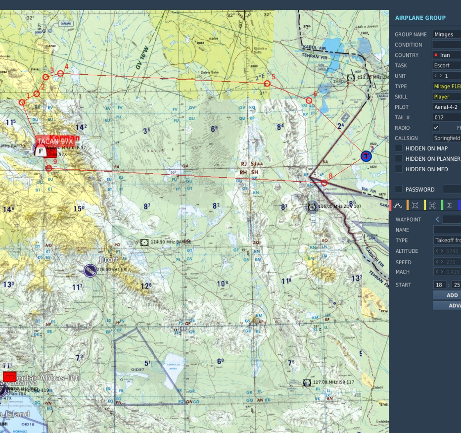
As Northstar98 already said, there is quite a bit of Afghanistan in the Persian Gulf map (full extent not shown below). I have been making a campaign where the US strikes Iran and part of Iran's strategy is to strike US and allied positions in Afghanistan. The missions are from the Iranian point of view. I started this mission pack years before the strikes that happened last week. But yea, you can fly over Afghanistan right now but the terrain isn't great. But if I wanted to fly over Pakistani coast to get to Afghanistan, then this level is all that is needed.

-
Since when has any DCS map had full detail in every area? How demanding is mostly flat, low resolution terrain? Some of us already have flown over Afghanistan in DCS and it is currently possible to do it from the sea. As there is no fighting to happen at low levels in that area, it is not as if it needs to be super detailed. And, if adding lower detailed areas is such a drag on development, then the extra effort into making 3 separate renditions of low detail areas in 3 distinct maps just for Afghanistan alone perhaps makes a great deal of sense to someone who is not me.
-
This is absolutely fine with me. The Pakistani coastline is a big deal for Afghan scenarios, as it is in itself still contested area that can lead to flashpoint in the future.
-
Carrier ops are important to the timeframe ED is modeling in Afghanistan. Cutting out naval ops is basically taking a map with already extremely limited function, and removing the US Navy's Tomcat and Hornet contributions. The early Harrier strikes were flown from the sea as well. I don't at all understand why "there's too much detail" is a reason for deleting featureless water.