
GumidekCZ
-
Posts
870 -
Joined
-
Last visited
Content Type
Profiles
Forums
Events
Everything posted by GumidekCZ
-

NTTR MAP WRONG WEIRD TEXTURE COLOR TINT
GumidekCZ replied to GumidekCZ's topic in DCS: Nevada Test and Training Range
Soryy Bob1943, we try to post here only quality photos (digital) not the historic ones and color shifted. Yours are pretty, but are useless for our comparism. On the other hand, I think that even these old pictures shows that the terrain shlould not be so much color saturated. Your last picture with DCS F-16 is nice proof of my point here. -
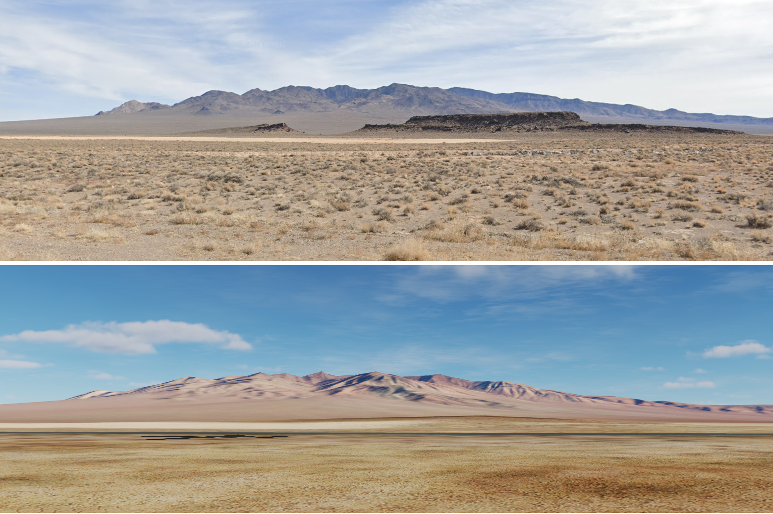
The map textures are out of anything I see from quality photos (taken from ground/form air). Compare the picture yourselves: Its not a big deal, not a bug, but because of that I feel like something not correct every time I fly a mission on this map. I my say, that I love this map, some more detailed elevation resolution would be very nice, but as long as you not flying low, it doesn't really matter. It seems to me, that someone who took care of NTTR textures has color shifted display tuned for COLD setting. Picture form DCS and Google picture from exact same spot (similar day time): Edited DCS screenshot compare: This is another compare of 60% screenshot with the original one, and small terrain photo in middle.

-
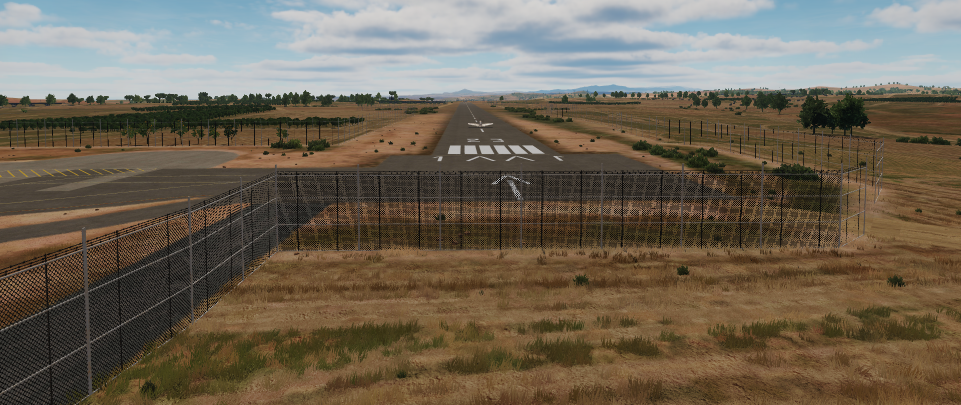
REMOVE THE FENCE. There is no tall fence around the airfield in RW. https://momento360.com/e/u/23287f49830d4b108e8efa10ab47fff2?utm_campaign=embed&utm_source=other&heading=-284.00&pitch=-25.00&field-of-view=50&size=medium Real look of airfiled without any tall fences or fences at all. Now in DCS
-
Wrong AVERAGE WIND SPEED GRADIENT with increasing ALTITUDE
GumidekCZ replied to GumidekCZ's topic in General Bugs
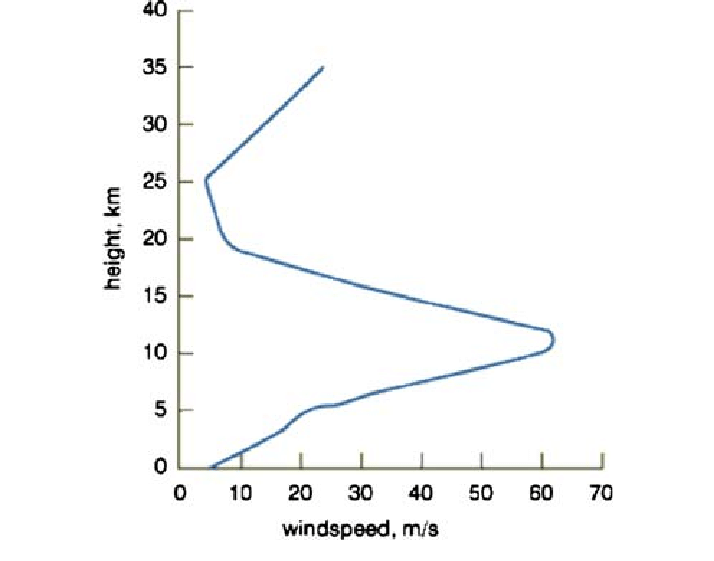
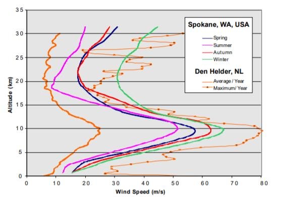
I guess where you see maximum flexibility, I see totaly unrealistic winds in majority of missions. Where did you get these values? Im very intereseted to see the source. I will send you one of many I found as interesting wind gradient source: http://showcase.netins.net/web/wallio/MZW.html It show very similar gradient, same as other graphs across the internet (with maximum speed around 12000m (~40kft)). Than the wind strarts to slow down, commonly due to shear winds or other atmospheric phenomena. Sadly your provided data dont include speed at higher alt than 12km. Most of DCS players will fly higher than 12km only very sparsely, but ballistic or A-A missiles commonly climb higher than that. ED, please, don’t be forced by anyone to do anything you don’t want. Do it your way as always. Neither me or Ironhand we can’t represent majority of DCS end user community. So explore the costs and benefits for regular DCS player, who use Editor tool, to create his own missions for his friends, or just for himself. If you ED find that Editor dont need any improvement now, PLEASE check your missions and tune the higher winds, to not be the Zero, but something more realistic. Many thanks. -
Wrong AVERAGE WIND SPEED GRADIENT with increasing ALTITUDE
GumidekCZ replied to GumidekCZ's topic in General Bugs
I'm totaly aware of that, expecting to be fixed with fully finished AH-64 Still, you all know, that 1600ft speed value is now connected to 33ft speed. So how difficult can be to connect rest of higher alt speeds all together with some coeficitent multipliers (green numbers at my setup) and add some slider control to be able to adjust the gradient. This solution will cause no need to rebuild weather system in DCS, but only DCS mission editor. Easy to control wind by just one speed value at 33ft and by adjusting slider. The mission wind will be than more realistic, than it is now in many many many missions without zero wind speeds. I hope that we all aim for realism in DCS. This one would need just only "small" rework of wind mission editor. -
Wrong AVERAGE WIND SPEED GRADIENT with increasing ALTITUDE
GumidekCZ replied to GumidekCZ's topic in General Bugs
Thanks, but I same as above, must note here, that this topic is not about speed value at single altitude, but about gradient from ground to DCS max alt possible. See the graphs I send in first post. -
Wrong AVERAGE WIND SPEED GRADIENT with increasing ALTITUDE
GumidekCZ replied to GumidekCZ's topic in General Bugs
Have them all , thanks Where? What suggestion? You mean your claim, that 41 knots at 26000ft is unrealistic? Thank you very much, but you didnt wrote any link to support your claim and on top, values of the wind speed are out of this topic. This is mainly about wind gradient across the DCS altitude. That document you send in link is interesting, but unfortunately for me, I dont have so much time to read it. May be you already did, and provide us with proper gradient values for DCS maps. That action would be appreciated by me. -
Wrong AVERAGE WIND SPEED GRADIENT with increasing ALTITUDE
GumidekCZ replied to GumidekCZ's topic in General Bugs
I understand to what you want to tell me, and I must admit, that its not an ordinary bug. Let say, that DCS editor will allow us to tune amount of sunlight without connection to day time and date of the year. So if it will allow to you to set zero sunlight at noon... is it bug or not? We all know, that pitch black at noon is absolute nonsence, but if it is mission designer choise? Same with wind, 0 knots(m/s) at higher altitudes when wind is blowing on ground, it is same nonsence, but editor now allow you to set it this way. Your 26 000 feet is roughly 7,9 km altitude and speed 41 knots is around 21 m/s. According to chart form Den Hleder - NL, Avarage year wind speed at this altitude is around 23 m/s. I dont know what calculations are you using, but for me, this is not unrealistic, especialy when you compare my wind speed gradient with the first graph on top. Next time when you write about something unrealistic, try to put here some evidence, or rather to not write here at all. * The only idea to solve this I have now, is to connect all wind speed to one value of speed on ground and new wind gradient slider, which would allow you to control steepnes of gradient and thus speeds at higher altitudes. * -
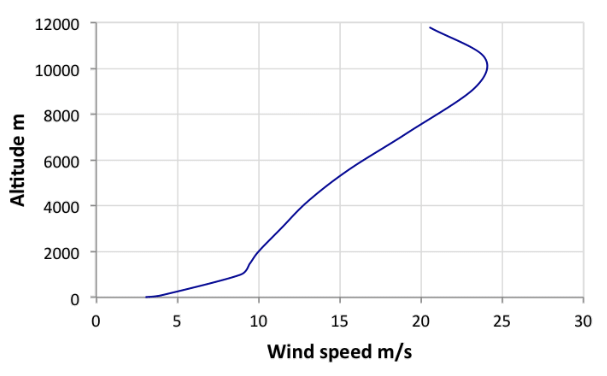
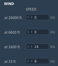
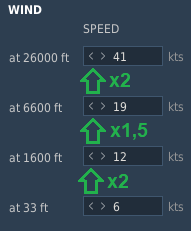
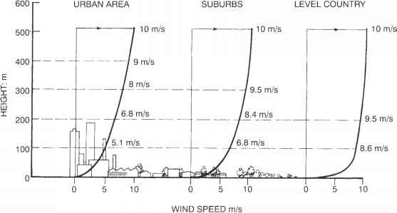
Reporting wrong wind speed GRADIENT defined in almost ALL mission across whole DCS and many 3rd party missions. - now in most DCS missions, WRONG! I will not research for ED what average wind speed values for certain map there should be set in ME. I can give only few examples from varios sources from internet, which show that its max speed is around 10 000 meters. There are many many research documents available on internet which shows detailed wind speed gradient near the surface, and how its affected by towns, suburban areas, open country, seas,... This my personal wind speed setup for one of my missions (Im not saying that this is 100% correct, just rough gues, what the gradient may be should look like):
-
Reporting bug, that (as title of this topic say): Instant action missions F-14A lacking 74X TACAN carrier preset . Its not a major but, thats for sure, but its very annoying if you have to set TACAN code over and over again every mission refly.
-
Reporting Bug present almost all Instant action missions with Carrier WP 1 speed slow. Initial WP speed 20kts which with head wind of 9 knots give us proper WOD speed (29 knots), but just after start of mission, Carrier will slow down to 11 knots (defined in WP1) and thus WOD will decrease to only 20 knots WOD. This bug is than creating problem to CASE I groove time to be to short and arresting speed for the hook higher than it should be. Edit: This bug may be is present in more than only instant action missions, but I didnt have time to check more than these.
-
- 1
-

-
Replying, to be on top of topic list, may be this time devs will answer. This feture was promised since Hornet first release, but didnt show up from devs anywhere anytime to be added soon.
-
investigating ALL IR guided missiles FLARE rejection inconsistency
GumidekCZ replied to GumidekCZ's topic in Weapon Bugs
Bumping up, to be more visible to ED devs and Admins. Hopefully, they will notice some day, and someone will take look into it. -
Searching for proof of underperforming AN/APG-73 radar
GumidekCZ replied to GumidekCZ's topic in DCS: F/A-18C
Guys, please, lets stick with topic. We are searching for evidence outside of DCS (real world) to compare it with APG-73 performance in DCS. Not to solve, why somebody cant lock MiG-23. If needed, create another topic or bug report with track and acmi attached. Thanks. Sadly as I spend couple of days searching any real world evidence, Im slowly loosing ideas, where else I can search for any valuable information. Not even single RCS value (or airframe type) detected at certain range was found . I really hope, that others like you, will be more lucky in that. -
-
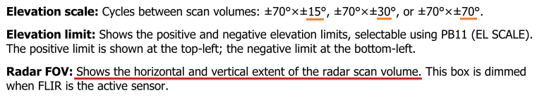
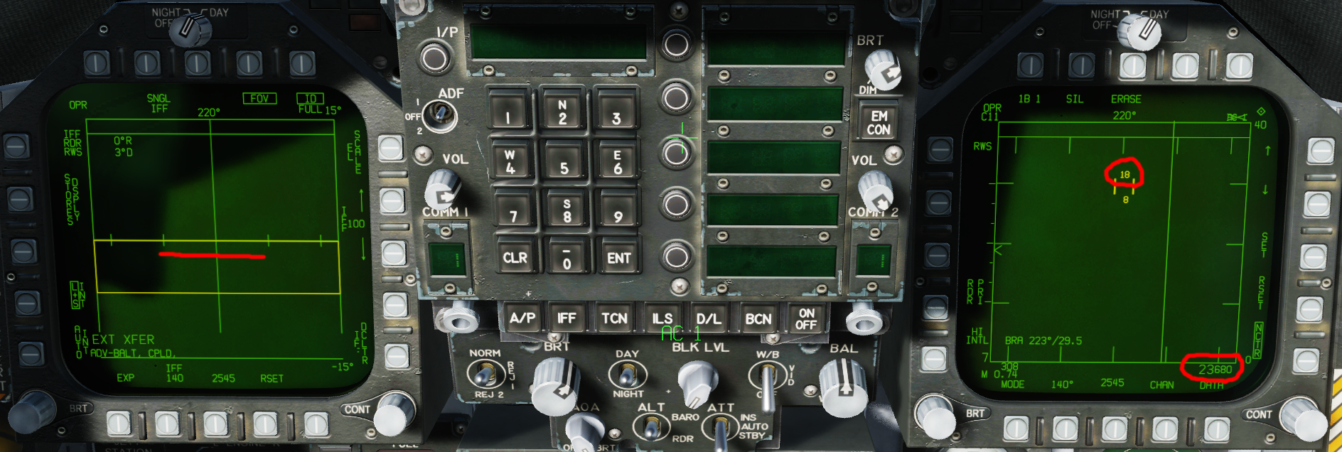
reported AZ/EL page radar scan outline wrong vertical limits
GumidekCZ replied to Steel Jaw's topic in Bugs and Problems
DCS 2.7.1.7139 Bug as reptort name, described here: -
Where did get that? You know what equation ED uses for detections? Im more than sure that this equation is not part of any script id DCS. Some much more simple one, may be somehow similar. It would very interesting, if ED could show us the equation, but I doubt that they will. We all know that ED uses for its scan performance definitions hard limits. Thats also reason, why you cant have HITS on your scope (radar return of low intensity which cant be declared as contact). With hard limit value, you simply have radar contact or not.
-
Searching for proof of underperforming AN/APG-73 radar
GumidekCZ replied to GumidekCZ's topic in DCS: F/A-18C
Some of these RCS values are another proof, that ED didn't made any deeper search for more less "correct" values. And RCS is now roughly based on size. One example for all: All sources across the internet will tell you that F-16A version has twice or more RCS than its C version block 50and newer. In DCS... Both variants have same value. But even bigger question raises, if we start debate, if this all matters, if ED is not counting with any loadout on pylons. Problem is, that ED would than need defined RCS value for every pylon and every weapon. But this should be discussed in another separate topic. -
reported AZ/EL page radar scan outline wrong vertical limits
GumidekCZ replied to Steel Jaw's topic in Bugs and Problems
It have to show radar scanned limits with correct angles (azimuth and elevation angles) for every bar number setting. If TDC lower height value is at level with airplane, than the bottom yellow line have to be exactly on middle green horizon line. Not 2-3° bellow. Same thing should work for upper scan angle limit. ------------- REPORTED AS A BUG --------------- -
reported AZ/EL page radar scan outline wrong vertical limits
GumidekCZ replied to Steel Jaw's topic in Bugs and Problems
Of course you can do that. But radar FOV limits should still represent exact limits of scanned area, even when scaled. There is no reason to have blind stripes inside of radar FOV rectangle. This what MANUAL say, not a word about blind areas bellow upper and above lower radar FOV limit.
-
reported AZ/EL page radar scan outline wrong vertical limits
GumidekCZ replied to Steel Jaw's topic in Bugs and Problems
Speaking of AZ/EL dispaly, recently I noticed, that FOV yellow rectangle do Not show exact limits of radar scan, but few degrees more (2-3°). So if you move your scan zone so that targets symbol almost touches the yellow line, ... contact will disappear. In other words, there is a blind area on the lower and upper edge of AZ/EL rectangle. THIS IS A BUG. If any of you will think the same, will than report this as a BUG. Luckily, this weird feature doesnt affect the sides of AZ/EL rectangle. Simillar test done, when I flown straight and set bottom scan altitude on radar display under TDC to my cooaltitude. The AZ/EL FOV yellow line was this 2-3° bellow horizon line.
-
Hi guys, does this method works for you even now after latest OB? For me, old TGP not overwriting coordinates in JDAM when slewing around, Undesignate button will erase coordinates from JDAM MSN page. FLIR is able to overwrite coordinates in JDAM, same as for TGP, Undesignate button will also erase coordinates from JDAM MSN page.
-
Searching for proof of underperforming AN/APG-73 radar
GumidekCZ replied to GumidekCZ's topic in DCS: F/A-18C
May be you can ask him also about this: -
Searching for proof of underperforming AN/APG-73 radar
GumidekCZ replied to GumidekCZ's topic in DCS: F/A-18C
When testing ranges, I also come to one weird thing, and thats upper hemisphere detection with AN/APG-73 is NOT automaticly striped of Doppler speed limits. Which are now 100kph or 27,78m/s. With such "modern" radar which also served shortly on Super Hornet, I would expect some automatic function like MLC AUTO in F-14 tomcat had many years before APG-73. Edit: For others, reading this topic, I must point out, that detect ranges were found with smallest radar scan settings possible. Any larger scan area will prolong time to detect the target after it pass by limit range for such RCS and thus the actual detection range can be much shorter (also depends on closure speed). -
Searching for proof of underperforming AN/APG-73 radar
GumidekCZ replied to GumidekCZ's topic in DCS: F/A-18C
Could this performance for APG-73 be from RW, or close to real? https://www.key.aero/forum/modern-military-aviation/15964-rafale-vs-gripen?page=7 APG-73 (F/A-18E/F, Block1) - (from Block2 was eqiped with APG-79 AESA) For RCS 0.0001 m2 class target: 5~6 km+ ??? For RCS 0.001 m2 class target: 10~11 km+ (5.5-6.1nm)->in DCS 5,5nm RWS / 3.0nm FLANK / 3.0nm BEAM (10nm ACM all) For RCS 0.1 m2 class target: 32~36 km+ (18-20nm)->in DCS 17.5nm HOT /9.5nm FLANK /9.5nm BEAM For RCS 1.0 m2 class target: 56~64 km+ (30-35,5nm)->in DCS 31nm /31nm FLANK /31nm BEAM For RCS 5.0 m2 class target: 84~96 km+ (46.6-53,3nm)->in DCS 47nm HOT / 47 FLANK / 47nm BEAM For RCS 10.0 m2 class target: 100~114 km+ (55.5-63nm)->in DCS 56nm HOT / 56 FLANK / 52nm BEAM DCS values checked by me, editing RCS values and than testing at 36000 ft, targets 2000 ft higher alt than me in Hornet. Scan zone AZ20° 1BAR. INT and HI PRF. Acording to values given from link page, DCS APG-73 is in average some 6% bellow average detection distance... which is far better than I was expecting. Big question now is the RCS values of each aircraft type in DCS.