Szprynmann
-
Posts
15 -
Joined
-
Last visited
Content Type
Profiles
Forums
Events
Everything posted by Szprynmann
-
Hi @Charly_Owl, I can't find a dedicated thread for AV-8B, but I found a small error in your awesome manual, Part 14 (navigation...), point 4.6 (waypoint sequencing), subpoint 10. Currently it reads: "Press IGRS ODU to toggle EGRS (Egress) option; this will select the Egress Route." I believe it should be "Press EGRS ODU..." Cheers, Szprynmann
-
Hi, Is 2.8.6.41066.1 build number the one with the quick fix for login issues? Just want to be sure that I have the newest version installed (and which unfortunately is also not working for me). Cheers, Szprynmann
-
I suggest checking VREST page, CRUISE subpage. It helps me to preserve fuel when possible.
-

Half of Normandy map missing in Mission Editor
Szprynmann replied to Szprynmann's topic in Bugs & Problems
Brilliant, thanks, that did the job Cheers, Szprynmann -
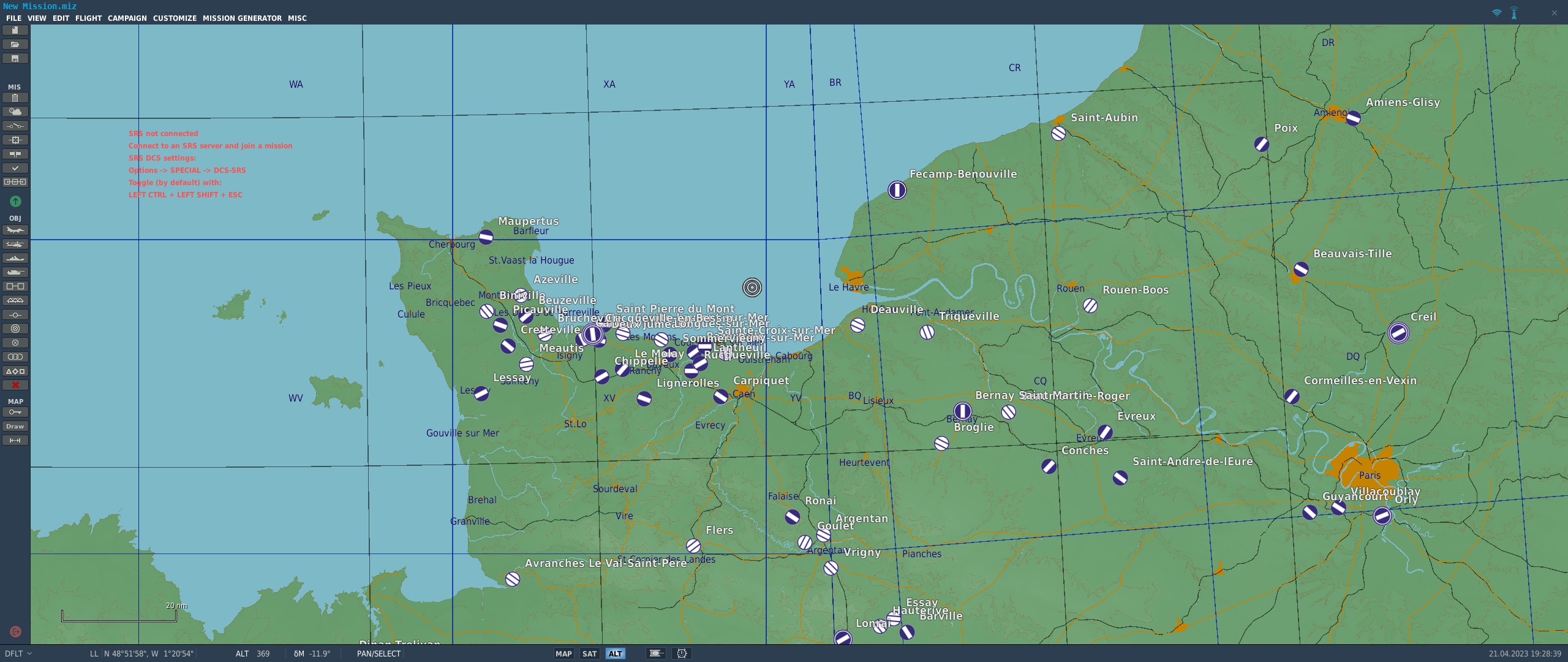
Hi, I had Normandy 1944. I bought the 2.0 map and this is what I see in the Mission Editor: I can see Paris, so it seems the new region is available, but the northern part is missing. When I trigger a free flight mission on the map I can see via F10 that it's there... I tried reinstalling the Normandy 2.0, I tried slow repair and I'm not fond of the idea of reinstalling the whole DCS. Any hints what could I do, or is it a bug? Cheers, Szprynmann

-
Hi, I fear there is still something wrong with mission 5. First of all, I call seeing the fall of tower almost immediately after the mission starts, while still on the ground. Please note that the time stamps are incorrect, it shows that 3 minutes have elapsed, but in fact it was something like 10-15 seconds... Secondly, I get the "Change to Norseman" command and then suddenly two wingmen dissapear... And yet I'm still waiting One hint: I might have pressed space too early or something. Looks like the triggers are working strangely. Cheers, Szprynmann
-
Hi, First of all- a very nice and challenging campaign Unfortunately, I've encountered a problem in mission 5 (and I feel it might be the same in other missions with a wingman)- Enfield is stuck on the ground (and funny enough- it has both afterburner and thrust reverser enabled), he won't move at all. Any idea how to deal with that? Cheers, Szprynmann EDIT: I increased the starting altitude of Enfield, and it did help
-
This is stage 1 AB on my aircraft, so I'd still say it's a bug You can try doing the same with e.g. low level supersonic flight on stage 3 AB- the wingmen keeps the pace, but no AB texture is visible inside the engine
-
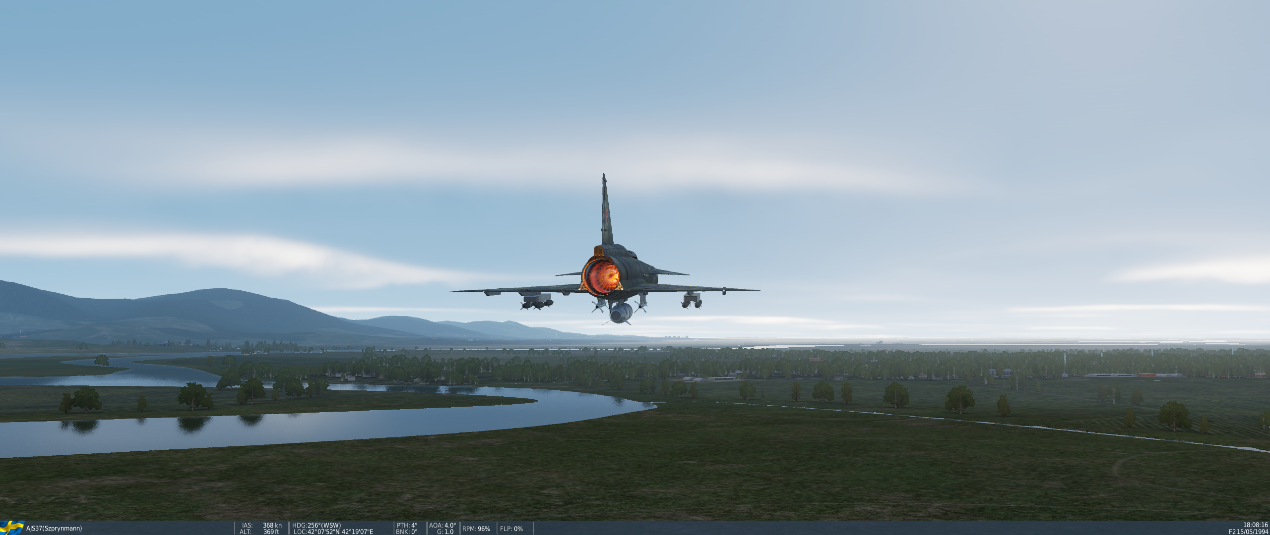
Hi, A minor texture bug in AI Viggen: the afterburner texture is missing (first screenshot). Player Viggen texture is ok (second screenshot). Best regards, Szprynmann
-
Issue was fixed in https://www.digitalcombatsimulator.com/en/news/changelog/openbeta/2.7.11.22041/ So it seems it was a DCS World problem, not limited to Viggen
-
I HAVE A DUDE TO USE VOR AND TACAN APPROACH WITH A 10 C
Szprynmann replied to mosqui's topic in DCS: A-10C II Tank Killer
When in distress every aid is helpful -
Viggen Patch March 17th 2022 Feedback Thread
Szprynmann replied to IronMike's topic in DCS: AJS37 Viggen
It doesn't work either- there is an actual response (visible on the screen), but there is no audio. -
I HAVE A DUDE TO USE VOR AND TACAN APPROACH WITH A 10 C
Szprynmann replied to mosqui's topic in DCS: A-10C II Tank Killer
This can be done in a quasi-precision way. From F10 map a touchdown point can be established. Insert it into CDU (waypoint page), set SCALE as "Approach", STEER as TO-FROM, on the second page enable VNAV 3D mode, type in the approach slope (e.g. 3 deg) and insert it (do it twice to have -3), set desired CRS, set PTR on NMSP to ABLE, use STR PT and you're good to go IMHO not as precise as an ILS, but it works quite good. -
Viggen Patch March 17th 2022 Feedback Thread
Szprynmann replied to IronMike's topic in DCS: AJS37 Viggen
Hi. I confirm other reports- there is no audio response from ATC when using radio. It does however respond (I can see the message on the screen). FYI: no such problem e.g. on A10. Additionally, the ground crew intercomm button does nothing, ground crew has to be contacted via '\'. Cheers! -
Hi Chuck, Could you please verify part 16, chapter 12 (TERNAV)? I was playing around with switching TERNAV on/off and it seems that 580 turns it on, whereas 581 turns it off, contrary to Your guide. Heatblur's manual (page 169) confirms that: Thanks!