ZaltysZ
-
Posts
942 -
Joined
-
Last visited
Content Type
Profiles
Forums
Events
Everything posted by ZaltysZ
-
I don't think this is possible, however you may use Shkval TV, it shows IAS at top left corner.
-
Well, pilots are not briefed during a flight, but before it. Of course, you can always launch clean mission editor before flight to get all information about terrain and simulate some part of briefing, but F10 is bad (especially if multiplayer server has disabled it). In anyway it looks strange for me that ABRIS has required data, but has no ability to present it to pilot. Logically, info tool should (could) display terrain elevation together with coordinates. Maybe it is just design flaw...
-

Being hit in the rudder and YAW control
ZaltysZ replied to skypirate's topic in DCS: Ka-50 Black Shark
Ka-50 has coaxial rotor mechanism. Yaw is controlled by differently varying pitch of both rotors. Right pedal increases pitch for lower rotor and decreases pitch for upper one, left pedal does the same just in opposite. At high speeds such yaw control is ineffective so that is why Ka-50 has tail rudder which comes handy as speed increases. Rotor and tail rudder yaw mechanisms are addition to each other. -
F10 works only if one of 3 options is enabled: Show my aircraft, show enemies or show allies. If none of them is enabled, F10 won't work. I personally don't want to have nor backup GPS, nor pseudo "AWACS" view, so F10 is not solution for me.
-
Of course he can, VNAV mode is for that, however it requires input of desired altitude. If pilot does not know the height of mountain, he will not know what desired altitude he should enter in to VNAV. Measurement tool gives coordinates, distance and bearing; info tool gives coordinates only (in case of mountain).
-
Lets model a hypothetical situation. Pilot wants to change his flight plan drastically and wants to accomplish his flight optimally. He creates waypoints inside ABRIS, but notices that high mountain is on his route. He assumes that usage of VNAV mode will be great help, because it can calculate required climb rate and initial climb point, however for it to work pilot needs to know what altitude he wants to climb to. The required altitude is mountain height + 100m. How can the pilot get the height of that mountain from ABRIS? ABRIS uses topography data together with aircraft's altitude reading to mask/unmask parts of threat zones, so ABRIS certainly has required data for determining surface elevation above sea level, however it seems that ABRIS UI has no means to display such data, or simply I have missed them. Has anyone found a way to solve such problem directly or indirectly? P.S.: I am interested only in determining elevation in advance while flying.
-
X52 is non FFB stick. It has only simple single Saitek style soft spring. :)
-
You will have to keep the joystick in the right position in order to have a stable flight attitude even with force feed back stick, if you are not using the trim button. Trim usage is essential. All those issues like "autopilot is fighting me", "helicopter turns around wildly", "my aircraft drifts badly in hover mode" is related to improper use of trim. P.S.: don't keep pressing trim button - it is bad! press it, hold it pressed, make attitude corrections, release the button. If you have FFB stick, that is all; if you have non FFB stick, neutralize the stick as quickly as possible after trim button release.
-
Try to use Process Monitor and capture Windows events. You may find the reason by filtering and examining those events. You may find Process Monitor here: http://technet.microsoft.com/en-us/sysinternals/bb896645.aspx
-
You are not supposed to always get 100%. Mission success does not equal to your personal success. Mission success equals to your side success. Your side is made from you, friendly aircrafts, friendly ground units. Sometimes you can't physically kill everything and in time, but again, you not supposed to be hero, are not supposed to do the job in which friendly tanks have screwed. Fly realistically, engage realistically, don't risc; don't just hang near the tank shooting at it with cannon to get higher score. 50% is enough, as 50% means that your side have won the missions and it will advance.
-
Stupid people don't ask at all. That is the greatest obstacle in their path to wisdom.
-
Beer? No no, beer does not fit here, Ka-50 is Russian helicopter. To drink beer in Ka-50 the same as drink Cola in Apache. You really had to have some vodka. :doh:
-
Printed Black Shark Manual Purchase, Europe
ZaltysZ replied to Wags's topic in DCS: Ka-50 Black Shark
I am interested in extended PDF manual for $10. :book: -
Aren't you accidentally pressing trim button? I just made a little test: applied full left rudder and trimmed it there, then pressed "z" or "x" keys and indeed, they centered the rudder. Seems like you are experiencing the same, so pay attention to trim button (you may be hitting it accidentally, using wrongly or have mapping conflict).
-
Printed Black Shark Manual Purchase, North America
ZaltysZ replied to Wags's topic in DCS: Ka-50 Black Shark
I am for paper version only for books which can be read sequentially. In any other case, electronic variant is superior. Even if the printed manual was included with game, I still would be using pdf version. Search function saves time and electronic documents save forests. :smartass: -
Make that icon (shortcut) of profile without telling which program you want to launch. Open properties window of that shortcut and copy "Target" line to your own batch file, then add whatever you want after that line: calling another batch file or exe and etc. By launching that batch file you will change active profile and run what you want automatically.
-
If I remember correctly, ATI catalyst lets to change profile via shortcut (in other words: via running program with parameters). I think it is possible to create batch file, which could change active profile before launching DCS and switch back to default one after DCS is closed.
-
Not your usual collective mapping problem
ZaltysZ replied to bankerzilla's topic in Bugs and Problems
Unplug X45, launch the game, go to control setup window. If "Virtual HID device" is absent now (because X45 isn't plugged), then you have driver problem with X45. -
Not your usual collective mapping problem
ZaltysZ replied to bankerzilla's topic in Bugs and Problems
What is "Virtual HID device" in your setup? -
Optical autotracking or manual targeting only; laser range finding and target designation.
-
Funnel Attack(Trichtermanöver) Video
ZaltysZ replied to Intruder_360's topic in Screenshots and Videos
In real life you probably would be dead with such application of funnel. :D Even doing funnel around innocently looking trucks could be dangerous, because you can't know what evil is inside them. It is game however and we have to face "dumb" AI and its deterministic behaviour, which could be greatly exploited. In anyway, video looks interesting, however I have advice for you. Before recording video, change display aspect ratio to widescreen via lua files, then record and in the end use video processing software to resize whole movie to widescreen. This way you won't have black bands or distorted video in youtube even if you can't run the game in widescreen. Also, try to change altitude frequently doing funnel. It won't make funnel a safe manouver, but still it will be safer when with constant altitude. -
Not your usual collective mapping problem
ZaltysZ replied to bankerzilla's topic in Bugs and Problems
Do you have any profile loaded into Saitek SST (Saitek programming software)? It may conflict. Also, I have said "JOY_Z should correspond to throttle", but it may not. I have X52, so axis labels may be different after all. Have you tried all axis (yes, I know there is a lot of them)? -
Not your usual collective mapping problem
ZaltysZ replied to bankerzilla's topic in Bugs and Problems
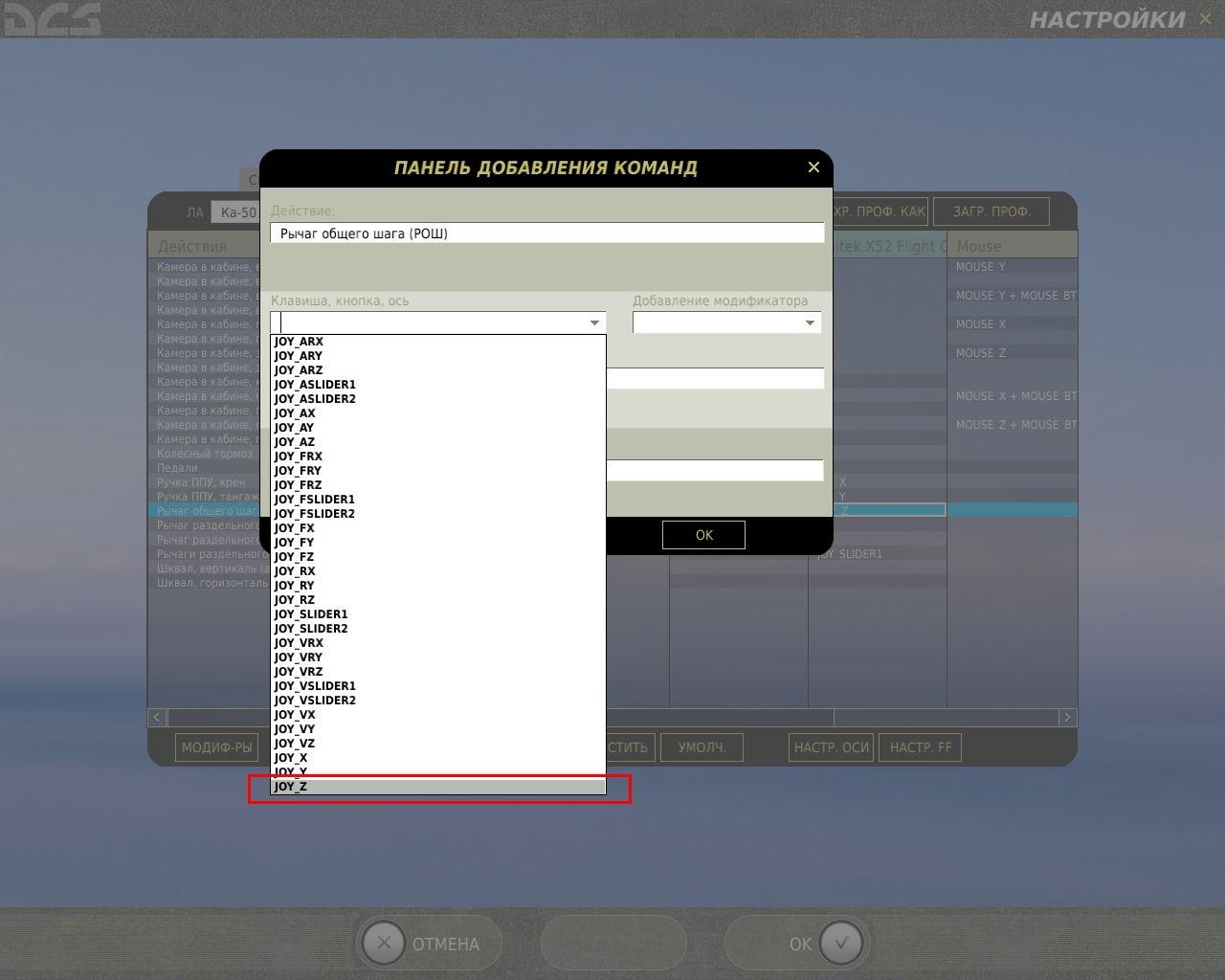
You don't have to rely on auto detection, because you can assign axis manually. Open axis assignment window and with mouse choose "JOY Z" as axis. "JOY Z" should correspond to X45 throttle. See the screenshot I have attached (it is in Russian, but I think you will understand as only text differs from English window of axis assignment).
-
Screenshot will say everything: I think that main gun elevation should be something like 20 degrees max.
-
Yes, it is design limitation. After vehicle is destroyed, it disappears from game, although the wreck can still be seen (something like craters - just eye candy).