nickos86
-
Posts
371 -
Joined
-
Last visited
Content Type
Profiles
Forums
Events
Everything posted by nickos86
-
Do you "restart" the AI aircraft (I guess to refill his fuel tanks)? Because the AI don't initially appear on the DL but they do reappear later... If you're doing something like that to manage their fuel- can you do it 5 min after mission start to overcome the DL issue (5 min should be more than enough to complete startup and stored heading alignment)
-
I think it was already requested in the past. I think it's super useful and important. Moreover, it's a low hanging fruit. It will be so easy to implement (ATIS in kneeboard or via F10). Problem is, that generally speaking - ED tend to over complicate solutions for relatively simple problems. I bet it will be part of their new ATC system... But till then - they won't do an "ok" solution (while people don't even need more than "ok"). I hope I'm wrong... and ED will implement an ATIS brief (AI generated voice as it is IRL for AWOS and in ATIS at some airports... Or even just a written note). Same for METAR (that doesn't really change anyways at the moment... But of course can update... etc.
-
I agree with VampireNZ, it feels like the behavior haven't changed at all. Perhaps we're missing something or landing with the wrong technique? @NineLine Can you post your track with proper landing and aero-brake? I want to see how you do it and the stick deflections. Thanks!
-
Mute the ILS morse without shutting it down
nickos86 replied to nickos86's topic in DCS: F-16C Viper
At the bottom of the scale, before going OFF - you can still hear the morse sound. Usually this kind of hardware will have an On/Off detent at the edge, then a range based on the potentiometer to control the volume. I guess that if ED simulated the knob as a virtual axis then instead of going -1 (off)-->0(on)-100(max) it goes from 0(off) to 100(max)... So there is no "0" - the system works but the volume is muted (or it is implemented is way that is too sensitive for using with mouse clicks...) Not a super big deal... but the ILS sound is annoying when doing a full ILS approach. It seems to be a very quick and simple fix. -
Not sure if currently it is a bug/correct as is/wish-list item... But I assume the ILS morse sound should be mutable without shutting it down completely...?
-
It such an easy feature to implement... And so vital for gameplay... Honestly, I don't understand how is that not part of the game years ago?! The NVG is mealy a filter... Really, sometimes I'm unable to understand ED
-
From the latest "winter sale" video: https://www.youtube.com/watch?v=U71afaEynkg&ab_channel=EagleDynamics%3ADigitalCombatSimulator

-
Nothing fancy... Just something that will make that feature shine and the user will be able to experience it without creating complex scenarios on his own.
- 5 replies
-
- 12
-

-
No mods, happen in every map, clean missions with no objects/trigger/scripts... every time I hit "save" - the game will crash I've attached the log... Anyone got an idea? dcs (1).log
-
Why the SNIPER is a thing and something to be awaiting for? The current TGP is great with awesome zoom and resolution... IRL the benefits are mainly cost, perhaps ease of future upgrades, integration and maintenance... Nothing that makes a difference in a game. What am I missing?
-
Thanks for the quick answer! One more - will there be an option to add "Navigation target points"?
-
@BIGNEWY, are there plans to expand the "route tool"? At the moment it doesn't interact with the route the plane already got. It would be great to be able to edit it. Moreover, it's relatively uncomfortable to share the route to other players in your flight... Can you elaborate on the future plans for it?
-
What about tools for F-15E? Allowing to set target points, additional routes (B/C) etc. ?
-
For all aircraft, that can be nice to see the weight and balance (both on X and Y axis - to avoid asymmetrical loadout or to know how much should we trim before takeoff). Thanks.
-
I highly recommend you to watch some of growling videos on BVR (like the one I'll attach below). He's doing a really good job explaining how the tactics matter A LOT. You can also look for the discord and youtube videos of the TACT - you'll see how when someone experienced flying against someone less experienced - he manage to shoot him down even at 25NM+. Don't take this personally The implementation on the 120C of course never going to be 1:1 as the real deal... The real guidance algorithms are classified and the exact characteristics of the internal radar and electronics are classified... But per the assumption ED published in their newsletters - they took a realistic approach... So good chances the current implementation not that far from the real thing. Regarding your tacview, you were very slow when shooting the missile (~1.01M) for 25NM... Try accelerating to at least 1.3M-1.5M and shoot with a 20-30 deg of LOFT. Put him on the gimbel after firing and support the missile until pitbull.
-
Hi, please note that BVR is a VERY TRICKY game. Against a really good opponent - it will be VERY hard for you to shoot him down even at 6-8 miles because he knows how to defend (energy, not flying straight at you, etc.). The BVR game require A LOT of knowledge and experience. No offence but the problem is not the missile but it's you I strongly suggest going to servers like growling sidewinder, getting killed MANY times, exploring the TACVIEW and learning. You'll see guys hitting each other from 20+ NM and in other cases people dodging 120C from 7 NM... All a matter of proficiency. The 120C ain't a 'magic' weapon that will hit it's target from 30NM no matter what. I think you'll find it's super interesting to learn how to employ it properly and fight a good BVR fight... Just a small video showing how you can kill from ~18NM and at the same time - dodge the missile from your enemy
-
if you got something in PB17 - it will use it. Else - UFC
-
Note, there is not digital ALT map correlated to the RDR for the 15E. If you designate a target while the waypoint you fly to (via UFC) or picked up in the RDR is far from the designation - you'll get a large ALT error because the plane will try to interpolate the ALT.
-
In general DCS got quite a gap in all related to ground unit damage modeling and the effects caused by a weapon onto a specific unit. Just as you've pointed out, IRL you won't see a "DCS style" explosion when a charge hits a unit. It's not a GBU12 The "explosion effect" simply showed when the unit get destructed. You can argue that currently the damage effect and units damage models not modeled well... I'll be the first to agree with that.
-
So it should have been: "Fixed: TGP+GPS guided weapons = 15-20m Miss. Note: 3 Second laser or AGR required before release for increased accuracy." There should be nothing special about the GBU-38 in comparison to the rest of the GPS weapons.
-
Why would the GBU38 procedure be different vs the GBU31? Is the 38 a test bed for JDAM FM and features?
-
Hi, The increased accuracy followed by 3sec of lasing or AGR - is it a weapon thing? Is it relevant to all modules? Or is it a platform thing? In this case, what mechanism was flawed and now is modeled correctly? ED, could you please share some info regarding this fix? Thanks. Fixed: TGP+GBU38 = 15-20m Miss. Note: 3 Second laser or AGR required before release for increased accuracy.
-
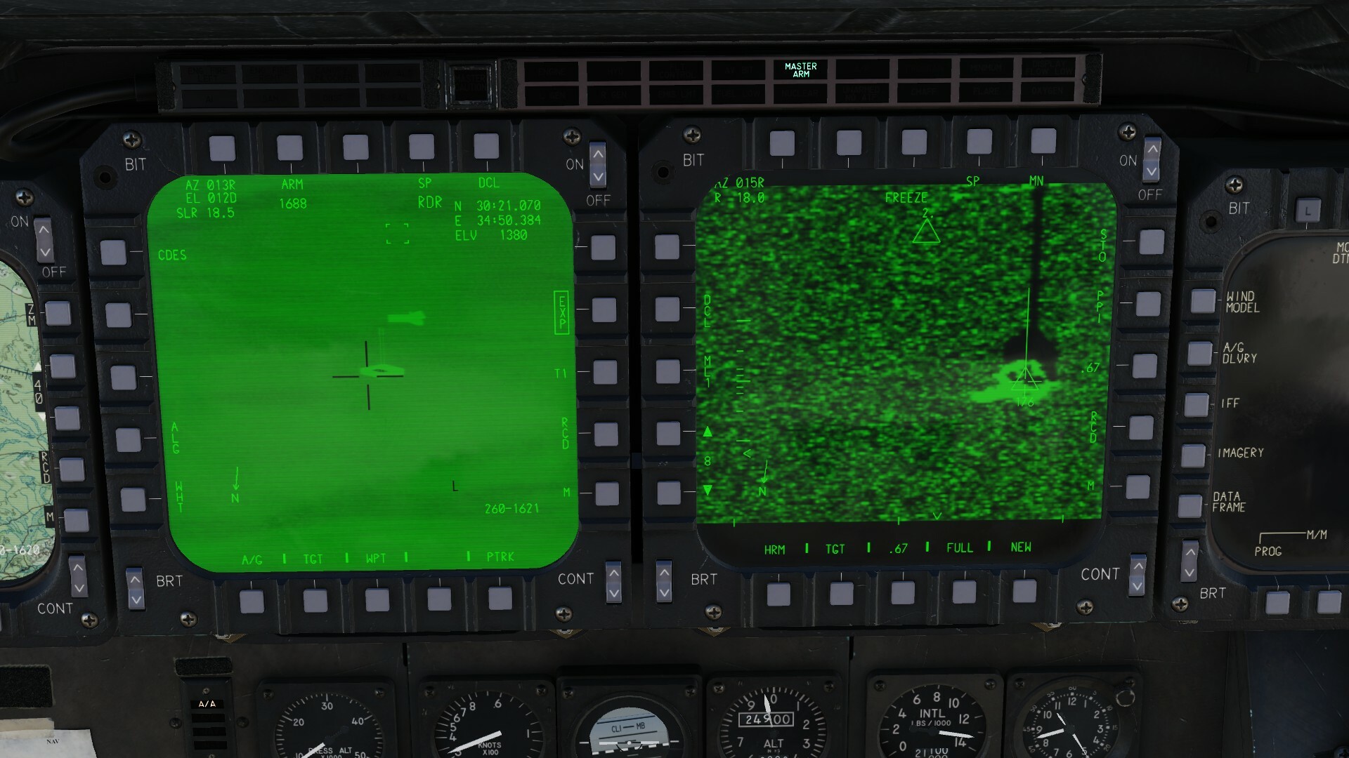
An interesting feature. If you designate a target via the RDR while the waypoint selected in the UFC is in the target area, the TPOD cues automatically to the designation and the elevation is quite close to the actual one (comparing to the F10 map). If you des a target via the RDR while the waypoint selected in the UFC is FAR from the target area- the delta between the RDR des and a TPOD will drastically vary. Attached two pictures. The target area is at waypoint 2. The target coordinated from the F10 map are: N 30°21.066' E 34°50.382' and alt of 1385ft For the first picture ,I've entered waypoint 2.A into the UFC and designated a TGT . The coordinates are very accurate. Same for elevation - 1380 vs 1385 ft. As for the second picture, I've entered waypoint 1A to the UFC and designated the target. Note that now the elev is 1900 ft! Something to consider and take into account when designating targets using the radar. After seeing the following thread: KlarSnow important input: "The Air to ground radar pulls the elevation from the steerpoint you have input at PB 17 in the upper right of the radar display. If you do not have a steerpoint up there, it pulls from the closest steerpoint. This is why your targetting pod is pointing in the air. It has no way to generate elevation off of an HRM map, only coordinates." So it's a good habit to set the steerpoint closest to target into PB17. But, seems like the "if you don't have a steerpoint up there, it pulls from the closest steerpoint" - doesn't work as intended. Rather, it pull data from the waypoint set in the UFC.
-
- 1
-
-
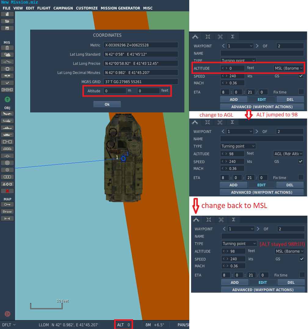
I'll try again. AGL= above ground level (height). In ME if you put 0 AGL - it should always stay zero. Doesn't matter if it is below sea level or on the Everest. MSL= mean sea level (altitude). If in ME you put 0 MSL - it should become the altitude above the sea level. if you set the WP on top mount Everest and dial 0 at MSL in the ME it should become 29029ft (but AGL should be 0!) In DCS (and I've attached a screenshot) - if you set MSL 0 - it automatically become the correct altitude. BUT if you set AGL=0 then it become 98ft instead! You can verify by moving the ALT back to MSL and you'll get MSL+98ft. This is WRONG. If you set a JDAM attack on a WP and in the ME you set the alt to 0 while in AGL - you'll probably miss the target because the alt becomes 98ft above the actual target. @BIGNEWY and @NineLine please take a look. Thanks.
-
Thanks for the responses! I would be cool if there was this kind of option in the stock version without using mods (perhaps even copy coordinates to the built in kneeboard).