=DECOY=
-
Posts
2359 -
Joined
-
Last visited
-
Days Won
3
Content Type
Profiles
Forums
Events
Everything posted by =DECOY=
-
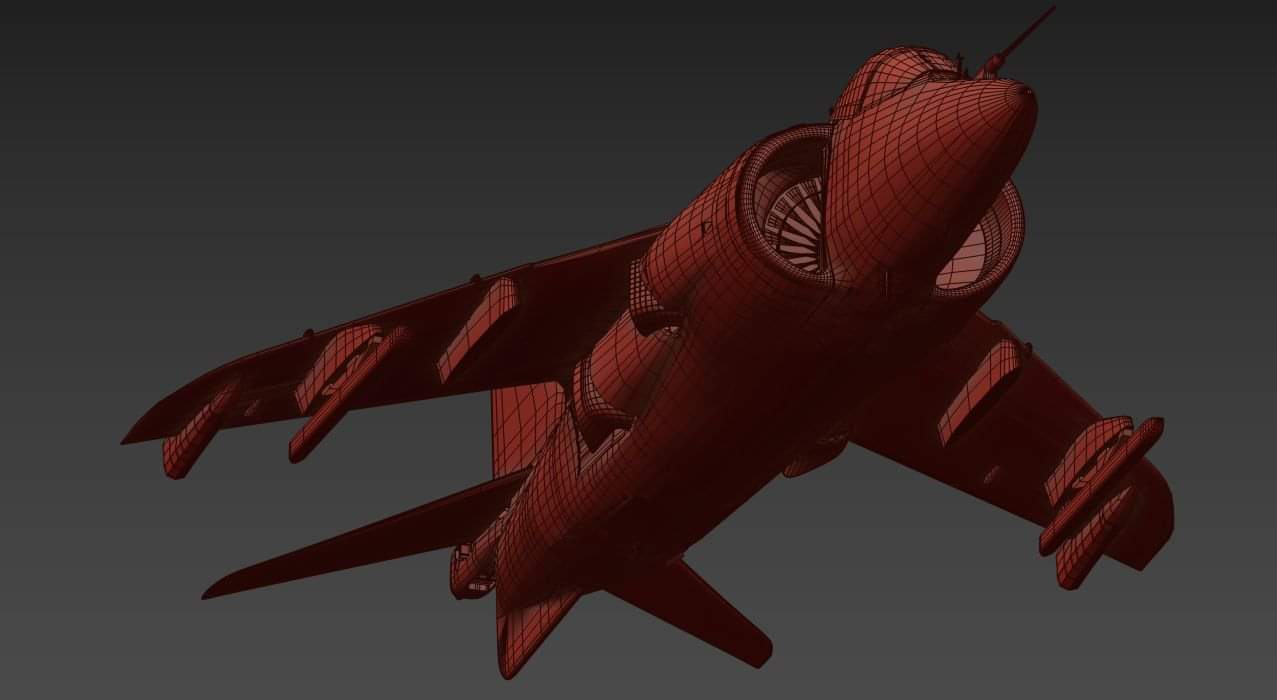
Good morning. Recently I have noticed a lot of rumours regarding which projects we are working on with a lot of old imagines are being shared on here and other social media with some believing we have started working on the eagle now. As stated many times we are still committed to completing our existing modules before moving onto coding for new modules. The 3D modeller for the eagle for the past 4 months has been busy upgrading the textures of the mirage cockpit and now finishing the amazing new pilot. When Tim has finished these tasks he will move onto the Eagle. When the Coders have finished the existing modules they will move onto new aircraft as its known we have 3 coders and 4 artists and a separate terrain team. This is what we are working on at the moment. Team 1 (two coders) are working on the existing aircraft bugs Team 2 (third coder) is currently working on FM tweaks Team 3 (3d modeller) is making the new VR pilot for the mirage (then the F15 model) Team 4 (3D modeller) is working on the Mig23 Team 5 (2x 3D modellers) are working on the ai assets for the falklands) Team 5 is making the Falklands map Hope this helps stop the rumour mill from spinning wildly out if control. Happy flying:pilotfly:
-
- 1
-

-
The F15 has been public knowledge for half a year and is still on HOLD until our existing modules are complete as promised. We haven't shared any new news or info on the Eagle, its NOT being worked on until the others are finished. Not sure why everyone is getting upset about old images being reshared, nothing has changed !
-
Hi, We are aware of this one and awaiting the return of the team. Once they are all back we will look into this one and fix accordingly
-
New VR pilot for the Mirage is coming along nicely. Wont be long before you guys get to enjoy the awesome model ;)

-
Here you go https://forums.eagle.ru/showthread.php?p=4148499#post4148499
-
You as well :)
-
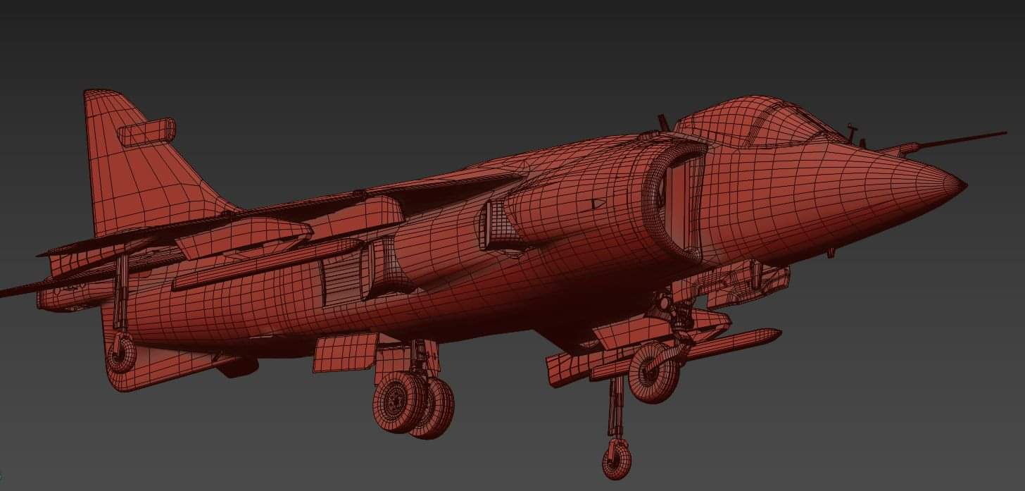
Merry Christmas fellow Simmers. Just a quick message from the Razbam team wishing you all a very Merry Christmas. We have officially broken up for the holidays and can’t wait to get back to work for what will be an awesome 2020 for us. Let’s talk about 2019 first. Yes we had our ups and downs and introduced a lot of changes as a business, We introduced the awesome MiG-19, our new Bug tracker to provide better transparency on the issues we are working on, the all new Discord channel allowing our customers another avenue to discuss our passion and most importantly we welcomed new members to the family including Leonardo our new coder. Last year we made a promise to complete our modules, this is STILL our top priory moving into Q1. We also provided you with the all new Harrier and Mirage cockpit textures and introduced new features such as the JDAM’s for the Harrier. And the all new Radio, NVG, ECM panel for the Mirage. These aircraft are still being worked on and will continue to be our focus moving into 2020, the all new bug tracker now shows you what we are working on, the state of testing and when the will be released to Open Beta. So, what are we looking forward to next year? In 2020 we aim to have all our modules finished with all new Sounds packs for the Mirage and Harrier; we are also very excited to continue working on the following Modules: • South Atlantic Map • F15-E Strike Eagle • Mig-23 Flogger • Super Tucano • FRS1 Sea Harrier We can’t wait to share more info on the above projects, and we wish you all a very Merry Christmas and a Happy New Year for the Razbam Team.
-
Yes Sent from my SM-G960F using Tapatalk
-
Can anyone here provide a profile they use for these ? Sent from my SM-G960F using Tapatalk
-
The info is for the real aircraft and its capabilities. I will remove the 32 and 54 as i can see the confusion :thumbup: The aircraft can carry the below as confirmed by pilot and ground crew of the USMC, as a note they train with the -54 GBU-38: Mk-82, which exists in game GBU-32: Mk-83, does not exist in game but can be carried in RL. GBU-54: JDAM with terminal laser guidance, used against moving vehicles. Does not exist in game but used in real life just in case here is a pic of GC loading -54 on a USMC Harrier And this i found very funny :lol: File:US Navy 061015-N-2970T-006 Marines assigned to Marine Attack Squadron Three One One (VMA-311) load a GBU-38 Joint Attack Direct Munition onto the wing of a AV-8B Harrier
-
This thread has been closed as it has become WAY off topic !
-
We changed hosting companies and I forgot to click the switch so to speak :) Oops lol Sent from my SM-G960F using Tapatalk
-
Problems with the hosting company, all back up and running
-
I have told the team to also post on the forum aswell, sorry these were not shared with you on here Sorry
-
This is to be to be confirmed, it's a massive undertaking for the texture team. Sent from my SM-G960F using Tapatalk
-
No work continues on both aircraft. Remember it's different teams :) Sent from my SM-G960F using Tapatalk
-
Hi, Today ED released a Hotfix for the TF-51. we also had items released today but didn't make it to the changelog. This is what was released today for the Mirage: RWR display cutting off symbology near the lower area. RDI: removed most of the ghosting on targets out of cone RDI: contacts, contact displayed at at the VTB botton GreenBox radio: MEM shows selected channel freq when in config mode CC modes: change all radar elevation/azimuth values Boresight not available for 530
-
Thanks for making us aware, I have passed to get looked at ASAP !
-
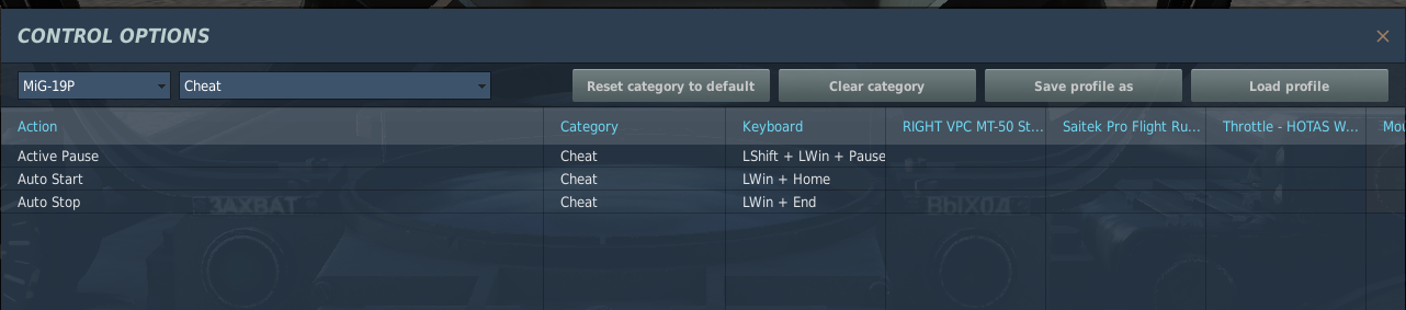
Help me out here , are you trying to use auto start with Right Alt + Home ? Because Right ALT + HOME is for Throttle left (IDLE) and Right ALT + END is for Throttle left (OFF) If your trying to use Auto start is LEFT WIN + HOME and LEFT WIN + END for auto shut down Look under Cheat section on the controls page, unless im miss understanding you, if so please let me know.
-
I have merged your threads, I will have a look and come back to you asap
-
PM me and i can help you
-
Glad you have it working :)
-
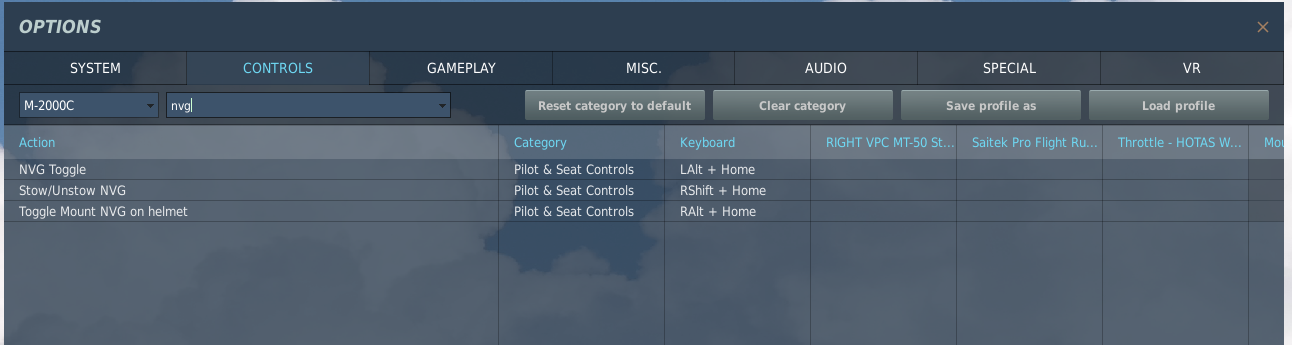
Check on my Beta running 40269 and can confirm the NVG are still in my settings and are working Are you on 40269 BETA ?


_lo.jpg.9b56dc37365b07e8f954b5b68d754cdb.jpg)