
Recoil16
-
Posts
1294 -
Joined
-
Last visited
-
Days Won
1
Content Type
Profiles
Forums
Events
Everything posted by Recoil16
-
It wasn't, it's still in the top left on the briefing strip.
-
CombatWombat's Airfield Diagrams: Syrian Theatre
Recoil16 replied to shu77's topic in DCS: Syria Map
79X in fact. Was missing from the original Cyprus release and added in the subsequent Syria update. That's probably why it's missing. -
I have started the A-10 multiple times in the recent update and haven't seen this issue. Could you provide a short track showing the issue?
-
I think mixing in other unrelated issues into a thread that already does not have a clear primary issue will not help its coherence. Creating one thread per issue is generally preferred.
-
You're creating a moving target. That satellite image was taken during construction at the airport, which is why the runway is only half paved. If DCS were to have its runways closed and opened based on IRL construction there would be a need for constant updating and maps would never get finished. To my knowledge, the runway construction at Bassel Al Assad is completed.
-
I'm afraid you will have to adjust your programs manually until such time as we either get DTC or this IC change is (partially) reverted.
-
As far as I can tell, all TACANs that should be are modelled. Please provide specific examples of missing beacons and documentation that cements their existence.
-
Hi, I do not know which Helipad you are referring to. Please include camera coordinates when reporting map issues:
-
Which is a somewhat disappointing thought
-
Good point. Didn't take into account magvar when I came up with those 04/22 numbers. I think the length discrepancy you're seeing there is the fact that the runway in DCS starts at the threshold and doesn't have the overrun or displaced threshold modeled that you can see on the south end on the sat images. But even then on the 2003 imagery the airport layout is entirely different from the one we have in DCS, with no taxiways going end-to-end, just a single one coming off the runway center.
-
Regarding the elevation: 72ft should be correct in-game. Gelendzhik is the worst offender to throw people off when comparing RL to the game because in 2004 (i think) it was completely reconstructed and today looks nothing like it does in-game. In fact the new runway that was built is 20+ degrees off from the previous runway (and the one we have in game). So I believe what has happened is this: - The runway and airport we physically have in DCS is in its pre-reconstruction state, when it was (i believe) runway 04/22. - The runway and airport were reconstructed from ground up, the new runway being runway 01/19, true heading 014°/194° (magnetic 007°/187°). See also the current airport chart of the reconstructed airport: http://www.caiga.ru/common/AirClassABV/validaip2/aip/ad/ad2/urkg/2-ad2-rus-urkg-031-031-1.pdf - Somehow the "numbers" (01/19) of the new runway have made their way onto the old runway that we have in DCS. Now the question is this: - What year is the Caucasus map supposed to resemble? If the year is supposed to be pre-2004, then the corrective action is to paint the correct numbers (04/22) onto the runway at Gelendzhik and change the runway numbers in the aerodrome data. If the year is supposed to be more current, then the airport needs to be remodeled from ground up to reflect its post-construction state. This will however also open up a slew of other issues at other airports (like the fact that Novorossiysk airport was closed decades ago or the fact that Sochi looks nothing like it does today).
-
I believe this is still an issue, as I recall the problem is that as you get closer to the PAPIs, the lights sort of fade out because they loose their "bloom" if that makes sense. So in fact, far out you can see them better than when you are closer. This is not only a Caucasus issue though, to my knowledge this applies to all PAPIs across the sim.
-
ILS and NDB's Still Not Working On Some Airbases
Recoil16 replied to VAF [136] Striker's topic in Bugs and Problems
Hey there, I believe this is likely connected to the ever lasting issues with ILS and wind, see also these threads: ...and many more threads. -
Really. Unless they fixed it recently, it only works in singleplayer and for the host in multiplayer, not for the clients. See also:
-
Some more, some less. But generally I'd say yes.
-
Scenery remove - if it works here - will only work in Singleplayer though, so that is less than ideal.
-
getMissionnode nodeIds is missing errors
Recoil16 replied to maverick90's topic in Bugs and Problems
In the mission editor. -
It's 47°C in that mission.
-
getMissionnode nodeIds is missing errors
Recoil16 replied to maverick90's topic in Bugs and Problems
See the FAQ: -
I fail to see the issue. It seems to me that everything would work just like it would IRL.

-
I disagree with that premise. The second arm/dearm area is right on South Ramp 7 next to 24L. I know the helicopters from HSC-25 are on North Ramp 1. Some other clues as to where bombers, tankers and AMC folks park can be taken from section 1.10 in the 36WGI13-204. It probably stands to reason that the aircraft shelters on South Ramp 1 near 06R are the place to park fighter sized aircraft.
-
In the 36WGI13-204: "4.3.4. There are no departure restrictions for practice ordnance, hot guns, or internally carried inert/live ordnance when the bomb bay doors are closed, or for captive-carry ordnance that cannot be jettisoned from the aircraft (either by combat or emergency jettison). Aircraft carrying heavyweight inert (≥500 lbs) ordnance, live external ordnance, or forward firing ordnance (FFO), must depart Runway 06R/L." I do not see the issue Nealius mentions though. The arm/dearm areas seem reasonably placed near the runway ends.
-
Nellis AFB active runway
Recoil16 replied to Vekkinho's topic in DCS: Nevada Test and Training Range
What it comes down to is that the current implementation of active runways at Nellis as designated by AI ATC is not realistic. Which wouldn't be a problem since I think that the AI ATC is useless anyways and I personally don't care for it anyways, were it not for the fact that a) approach lighting at Nellis is only turned on by ATC so it is basically impossible to get the 03R ALSF-1 activated, because ATC will give you the 21s even if you get a 40kt tailwind there (which is just nonsense) and b) the fact that AI listens to the AI ATC (duh) so they will inevitably go against the traffic flow if the player decides to operate in a realistic manner. At this point the AI ATC is a write-off for me, so the only thing I really want is that the ALS get permanently lit. The relevant passages from NELLISAFBI11-250 (dated 20 JAN 2016, no releasability restrictions): "4.1.2. RWY 21 is the calm wind runway. When prevailing headwind/tailwind component exceeds 10 knots, the runway most nearly aligned with the winds will be designated the active runway." "4.1.3. RWY 03 will be used daily from 2200L to 0800L for departures and RWY 21 for arrivals unless winds, air traffic volume or operational requirements dictate otherwise." -
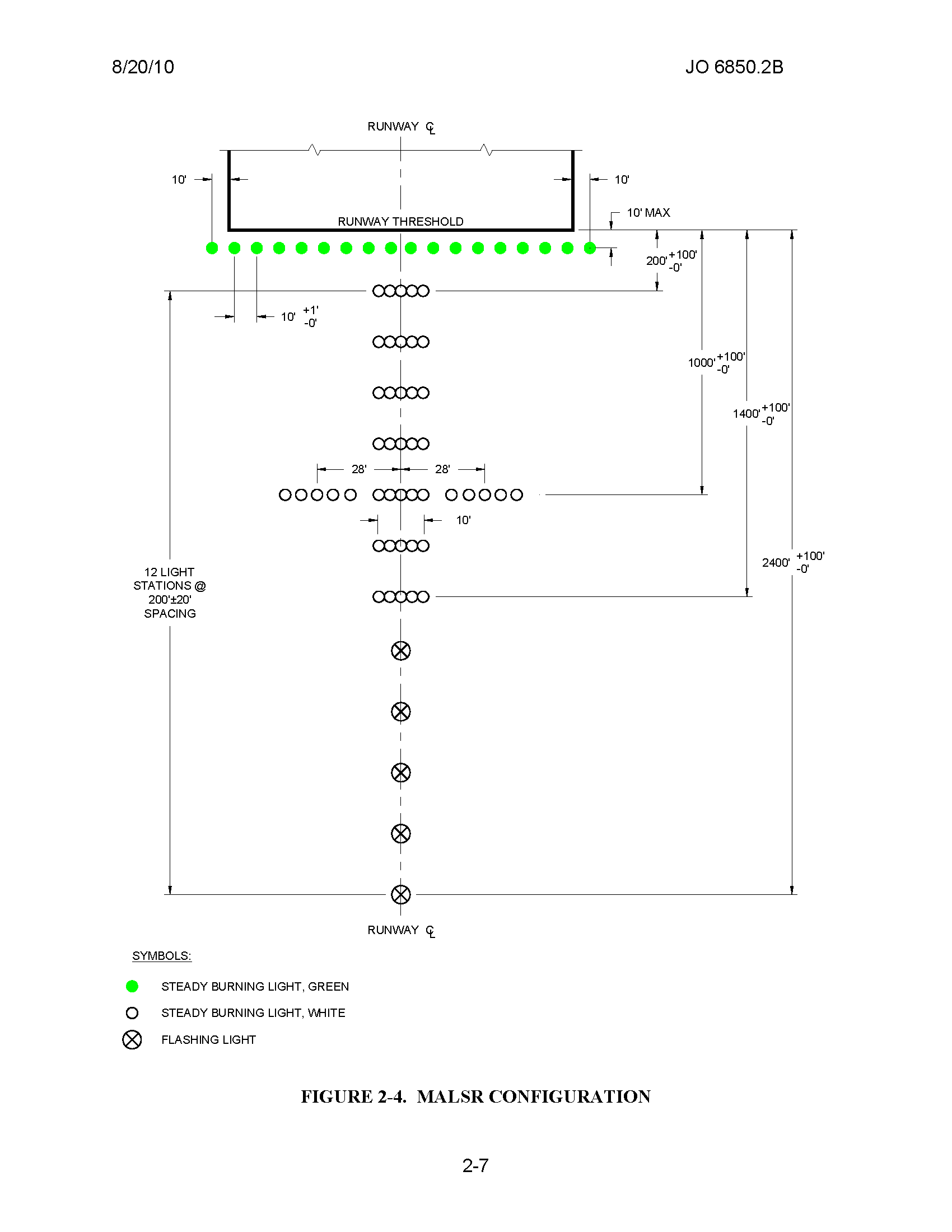
Yep. It's (supposed to be) a MALSR configuration, 2400ft in length measured from the threshold. The outer ones are supposed to be (and are IRL) single sequenced flashers: