
Recoil16
-
Posts
1294 -
Joined
-
Last visited
-
Days Won
1
Content Type
Profiles
Forums
Events
Everything posted by Recoil16
-

Joint-use (Civil-Military) airfields need fixes ...
Recoil16 replied to Backy 51's topic in Bugs and Problems
Israeli Air Force charts indicate it shares LLHB with Hatzerim, being technically part of Hatzerim Airbase. -
Approach and Departure charts, AIP and Enroute Charts
Recoil16 replied to ViFF's topic in DCS: Sinai Map
I wouldn't be so sure. SkyVector, and likely some of the other maps and charts there are copyrighted and not freely licensed or in the public domain. -
This was already reported previously.
-
Joint-use (Civil-Military) airfields need fixes ...
Recoil16 replied to Backy 51's topic in Bugs and Problems
Disagree. Israeli Air Force airfield charts as well as the Aeronautical Information Publication (AIP) Israel have this airfield as "Kedem". -
Can not set the Vaziani VHF AM frequency.
Recoil16 replied to JetJake76's topic in Bugs and Problems
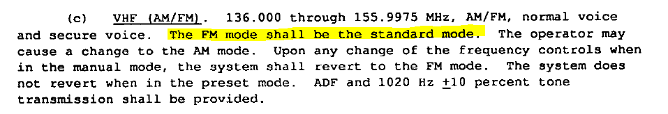
This is not a bug. FM should be the default state between 136.0 and 155.975, see page 34 of MIL-R-29583 (of 1 July 1992, Approved for public release; distribution unlimited, LINK), the specification for the ARC-210 (relevant excerpt below). You can just use the AM/FM button on the radio control head to switch to AM.
-
They weren't done by ED, but by @static_actual as part of the AH-64D livery competition if I recall correctly.
-
Already reported:
-
The included maps in DCS are the ONC and TPC series charts. Here are the ones for South Atlantic: https://maps.lib.utexas.edu/maps/onc/txu-pclmaps-oclc-8322829_t_18.jpg https://maps.lib.utexas.edu/maps/tpc/txu-pclmaps-oclc-22834566_t-18a.jpg https://maps.lib.utexas.edu/maps/tpc/txu-pclmaps-oclc-22834566_t-18b.jpg
-
You probably do, you just haven't seen it yet. Either way, it's reported.
-
It is included in the manual. Pages 310 and 311 describe the function of the Display Program (DP) page.
-
See here:
-
Correct. No, unfortunately, it's a regression.
-
-
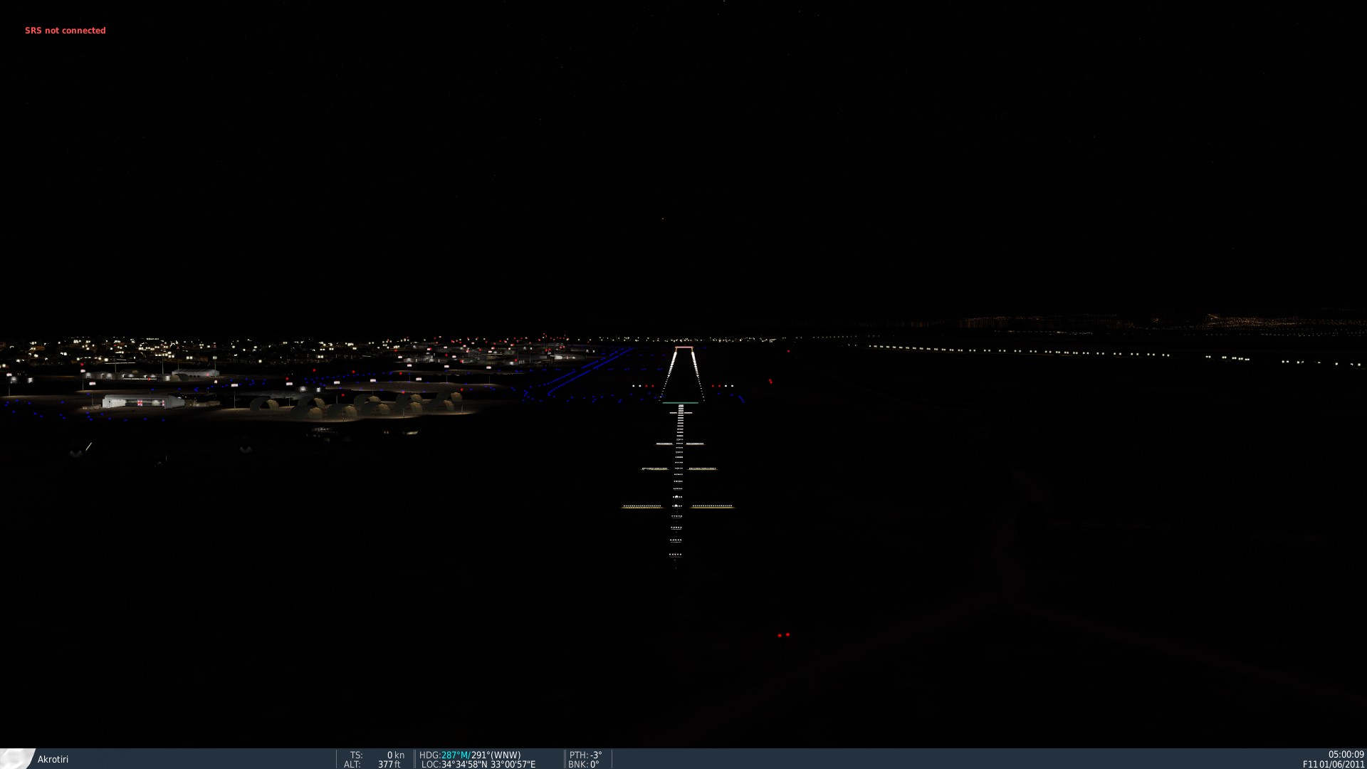
They do work, but not very well in day time (which is definitely an issue, and one that is not only present here at Akrotiri). At night they are fine (see below). Whenever the lighting changes that are currently on PG make their way to all maps this may no longer be as big of an issue (fingers crossed).
-
From the above linked FAQ: I would also say that the current Akrotiri was made by Ugra, a different company.
-
Using Scripting, two airfields (at least) have missing runways!?
Recoil16 replied to TEMPEST.114's topic in Bugs and Problems
I have attached a sample miz showing what I think OP is saying the problem is. Some runways are outright missing, some are mislabeled. Each runway should have one instance. From the below log, it is clear that something is awry. Creech for example is showing runways 8 and 26 in scripting, with "8" in scripting being 8/26, and "26" in scripting being 13/31 (which we can tell from the associated runway bearing). McCarran is showing 7 and 25 in scripting, with one of them being 7L/25R and the other being 7R/25L in reality (note that 1L/19R and 1R/19L are entirely missing). Similar thing going on at Nellis, where we have 3 and 21, which are really 3L/21R and 3R/21L. Similar situation at Boulder City, Henderson Exec, Jean, and Tonopah (civil not Test). North Las Vegas is great, where we got 25, 7, and 30 in scripting, which are really 7/25, 12L/30R, and 12R/30L. I could keep going but it's getting sort of confusing, which I believe is the point. 2022-12-08 12:59:52.604 INFO SCRIPTING (Main): Creech: 2022-12-08 12:59:52.604 INFO SCRIPTING (Main): RWY 8 2022-12-08 12:59:52.604 INFO SCRIPTING (Main): 91.543843822954° 2022-12-08 12:59:52.604 INFO SCRIPTING (Main): RWY 26 2022-12-08 12:59:52.604 INFO SCRIPTING (Main): 145.13981231548° 2022-12-08 12:59:52.604 INFO SCRIPTING (Main): Groom Lake: 2022-12-08 12:59:52.604 INFO SCRIPTING (Main): RWY 32 2022-12-08 12:59:52.604 INFO SCRIPTING (Main): -23.563346674222° 2022-12-08 12:59:52.604 INFO SCRIPTING (Main): McCarran International: 2022-12-08 12:59:52.604 INFO SCRIPTING (Main): RWY 7 2022-12-08 12:59:52.604 INFO SCRIPTING (Main): 88.870562423325° 2022-12-08 12:59:52.604 INFO SCRIPTING (Main): RWY 25 2022-12-08 12:59:52.604 INFO SCRIPTING (Main): 88.880029065514° 2022-12-08 12:59:52.604 INFO SCRIPTING (Main): Nellis: 2022-12-08 12:59:52.604 INFO SCRIPTING (Main): RWY 3 2022-12-08 12:59:52.604 INFO SCRIPTING (Main): 40.124864939683° 2022-12-08 12:59:52.604 INFO SCRIPTING (Main): RWY 21 2022-12-08 12:59:52.605 INFO SCRIPTING (Main): 40.136028883882° 2022-12-08 12:59:52.605 INFO SCRIPTING (Main): Beatty: 2022-12-08 12:59:52.605 INFO SCRIPTING (Main): RWY 16 2022-12-08 12:59:52.605 INFO SCRIPTING (Main): 179.85804635725° 2022-12-08 12:59:52.605 INFO SCRIPTING (Main): Boulder City: 2022-12-08 12:59:52.605 INFO SCRIPTING (Main): RWY 33 2022-12-08 12:59:52.605 INFO SCRIPTING (Main): -15.970090477683° 2022-12-08 12:59:52.605 INFO SCRIPTING (Main): RWY 15 2022-12-08 12:59:52.605 INFO SCRIPTING (Main): -81.519407404559° 2022-12-08 12:59:52.605 INFO SCRIPTING (Main): Echo Bay: 2022-12-08 12:59:52.605 INFO SCRIPTING (Main): RWY 6 2022-12-08 12:59:52.605 INFO SCRIPTING (Main): 77.385756428299° 2022-12-08 12:59:52.605 INFO SCRIPTING (Main): Henderson Executive: 2022-12-08 12:59:52.605 INFO SCRIPTING (Main): RWY 35 2022-12-08 12:59:52.605 INFO SCRIPTING (Main): -0.48213953169491° 2022-12-08 12:59:52.605 INFO SCRIPTING (Main): RWY 17 2022-12-08 12:59:52.605 INFO SCRIPTING (Main): -0.50099474914641° 2022-12-08 12:59:52.605 INFO SCRIPTING (Main): Jean: 2022-12-08 12:59:52.605 INFO SCRIPTING (Main): RWY 20 2022-12-08 12:59:52.605 INFO SCRIPTING (Main): -149.34502318367° 2022-12-08 12:59:52.605 INFO SCRIPTING (Main): RWY 2 2022-12-08 12:59:52.605 INFO SCRIPTING (Main): -149.33682695667° 2022-12-08 12:59:52.605 INFO SCRIPTING (Main): Laughlin: 2022-12-08 12:59:52.605 INFO SCRIPTING (Main): RWY 16 2022-12-08 12:59:52.605 INFO SCRIPTING (Main): 175.03574155792° 2022-12-08 12:59:52.605 INFO SCRIPTING (Main): Lincoln County: 2022-12-08 12:59:52.605 INFO SCRIPTING (Main): RWY 17 2022-12-08 12:59:52.605 INFO SCRIPTING (Main): -179.07135882902° 2022-12-08 12:59:52.605 INFO SCRIPTING (Main): Mesquite: 2022-12-08 12:59:52.605 INFO SCRIPTING (Main): RWY 1 2022-12-08 12:59:52.605 INFO SCRIPTING (Main): 27.606330304344° 2022-12-08 12:59:52.605 INFO SCRIPTING (Main): Mina: 2022-12-08 12:59:52.605 INFO SCRIPTING (Main): RWY 13 2022-12-08 12:59:52.605 INFO SCRIPTING (Main): -27.509534570974° 2022-12-08 12:59:52.605 INFO SCRIPTING (Main): North Las Vegas: 2022-12-08 12:59:52.605 INFO SCRIPTING (Main): RWY 25 2022-12-08 12:59:52.605 INFO SCRIPTING (Main): -92.506039892091° 2022-12-08 12:59:52.605 INFO SCRIPTING (Main): RWY 7 2022-12-08 12:59:52.605 INFO SCRIPTING (Main): -46.65621284294° 2022-12-08 12:59:52.605 INFO SCRIPTING (Main): RWY 30 2022-12-08 12:59:52.605 INFO SCRIPTING (Main): 133.30989735226° 2022-12-08 12:59:52.605 INFO SCRIPTING (Main): Pahute Mesa: 2022-12-08 12:59:52.605 INFO SCRIPTING (Main): RWY 36 2022-12-08 12:59:52.605 INFO SCRIPTING (Main): 13.440053512874° 2022-12-08 12:59:52.605 INFO SCRIPTING (Main): Tonopah: 2022-12-08 12:59:52.605 INFO SCRIPTING (Main): RWY 29 2022-12-08 12:59:52.605 INFO SCRIPTING (Main): -54.970895817731° 2022-12-08 12:59:52.605 INFO SCRIPTING (Main): RWY 11 2022-12-08 12:59:52.605 INFO SCRIPTING (Main): -14.971511698385° 2022-12-08 12:59:52.605 INFO SCRIPTING (Main): Tonopah Test Range: 2022-12-08 12:59:52.605 INFO SCRIPTING (Main): RWY 32 2022-12-08 12:59:52.605 INFO SCRIPTING (Main): -22.937312025466° RunwaysToLogNTTR.miz -
Known and fixed internally
-
I've misplaced my crystal ball, so I can't say. I certainly hope.
-
Schroeder airbase has it's runways reversed
Recoil16 replied to Bremspropeller's topic in Bugs and Problems
Reported -
Reported
-
If you think that trees and grass are the same thing, you are beyond help. Have a nice day.
-
You're making a bug report, in the "Bugs and Problems" subforum, which implies you think this is wrong. I don't know about you, but to me, an abandoned airfield not having its grass mowed regularly seems realistic and correct.
-
Probably because people keep asking for it to be usable despite the fact that it is abandoned. I'm just answering the question as to why Pagan isn't mowed, which makes a lot of sense if you ask me. But I guess you don't actually want that.
-
It's closed indefinitely per the A/FD.
-
Check the A/FD, it's closed indefinitely.