buur
-
Posts
636 -
Joined
-
Last visited
Content Type
Profiles
Forums
Events
Everything posted by buur
-
All the highways look very small. In Germany you have usually a emergency lane just a little bit smaller as a normal lane but only a little bit. This is mostly missing on the map and that makes it really hard to identify it from the air. Also at some areas I saw street lamps on the highways but this is only common for Belgium.
-
Bombing Trajectory Planner (WIP)
buur replied to Boagord's topic in Utility/Program Mods for DCS World
nice work. Where you get your Cx value from? DCS data? -
I will try it but it will be hard without some guidance from ED
-
Ok, your method was going via Tacview. Any idea to get the data from DCS definition files like Weapons.lua? For example in the Harrier Weapons.lua you found Cx = 0.000160
-
You have your own bombing calculator? What are your Cx values for your calculator?
-
Good arguments. Wondering if it is possible to change the numbers on the runway via script.
-
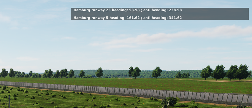
This is not only a CWGermany map problem but a general DCS problem. For CWGermany it is very demonstrative. Reason for this is that the DCS world is flat. If you measure the runway heading in the real word you get for Hamburg for example a heading of 332.88° and in DCS a heading of 341.62. This values without magnetic deviation. For naming a runway you have to decide with reality to follow. The real world? So you get the 33. Or you follow the DCS ingame heading and than the name of the runway should be 34. Ugra made the decision to follow the real world naming. For us this means that we cannot take the runway heading from the name but to look on the F10 map to get the right direction. Finally I can live with that. But I have to criticizes Ugra that they never give a explanation for the reason of the problem (which is not their fault) but leave us players with a big question mark in our heads.
-
in this articel (in German) the specs for a highway landing strip are described: https://www.bundeswehr.de/de/organisation/luftwaffe/aktuelles/autobahn-notlandeplaetze-waehrend-des-kalten-krieges-5615300
-
Don't see your problem. For me it was a nice touchdown. Couldn't see your weight, maybe a litte bit heavy.
-
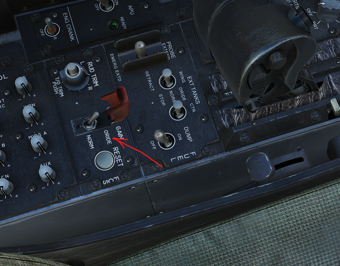
Try to override the gain. This helps for me. https://forum.dcs.world/topic/380238-any-suggestion-to-air-refuel-the-18-in-vr/#findComment-5704454
-
For the AI I use following formula for the relation of IAS and TAS for slow moving planes like tankers. IAS[kn] = TAS[kn] * ( 1 - 1.34*10^(-5) * h[ft]) This formula is only valid for AI because for AI there is no influence of temperature or pressure.
-
as speed-of-heat has written, simply place your general kneeboard pages in the top folder and you see them in all planes.
-
For me AAR is easier when I override the gain. Than I have more sensitivity.

-
nice application. Thanks for sharing
-
So, gerade mal probiert und nachdem ich beim ersten mal ejecten prompt in einen See gelandet bin konnte ich beim zweiten mal den Pilot mit den Pfeiltasten laufen lassen.
-
do we have any comment by a developer on this topic up to now?
-
sorry not talking about magnetic but about geographic bearing.
-
Compared the runway headings for Hamburg, Pferdsfeld and Frankfurt and all all of by +10°. For example in DCS Hamburg is 342° in DCS and in real world it is 332° (Checked with Google Earth.) See also that the coordinates are ok, only the bearing is wrong. Is in Ugra's map the pole on the wrong position?
-
unfortunately not. You can't slave the HSI or the radio to the NS430. You have to use the NS430 internal HSI and set the course in the normal HSI by hand. Radio has no function.
-
You can do a flight planning based on waypoints and fixes in the database. Also on some maps you can fly approaches.
-
hast du den historischen Filter an? Mach ihn mal aus. Und sonst sind die wie beschrieben unter Unarmed→RSBN car
-
Hi guys, here a small script to determine the exact heading of the runways. Simply execute in a DO SCRPT trigger and change the airport name in the first line. Think could be helpful for the exact alignment. myAirbase = Airbase.getByName("Pferdsfeld") rny = myAirbase:getRunways() name = myAirbase:getName() if rny then for j = 1, #rny do local bearing = rny[j].course * -1 degree = bearing*180/math.pi if degree < 0 then degree = 180+ degree end antidegree = degree + 180 if antidegree > 360 then antidegree = antidegree -360 end rnyname = rny[j].Name local text = string.format( '%s runway %s heading: %.2f ; anti heading: %.2f',name,rnyname,degree, antidegree) trigger.action.outText( text , 20 , false) end end null
-
and now for ICLS and ILS
- 52 replies
-
- 12
-

-
ok, NTTR is relative easy cause that the US had good data sources for aeronautical data. If you need the beacon data from DCS I have a script for a quick read out.
-
I'm interested in map making for DCS and therefore your scripts could be very helpful. Are you willing to share them? And yes we shouldn't hijack little nose thread...