
DD_Fenrir
-
Posts
2052 -
Joined
-
Last visited
-
Days Won
3
Content Type
Profiles
Forums
Events
Everything posted by DD_Fenrir
-

reported Default Spitfire Roundel Colours & Dimensions
DD_Fenrir posted a topic in Bugs and Problems
1. Are incorrect tone and hue. The tone is too light in the blue and there is too much pink, giving the blue a near indigo/purple hue. The red I feel is closer but would be easier to interpret if contrasted against the correct blue. DCS default Spitfire scheme: Original colour photographs (NOT COLOURISED): http://www.spitfiresite.com/photos/historic/uploaded_images/Spitfire-AA963-color-1-732027.jpg 2. As has been repeatedly requested, could you PLEASE correct the proportions of the roundels to better reflect the WW2 standard (I know MH434 was referenced during the research for this model, but her roundel proportions are plain WRONG) and to better represent a WW2 airframe. -
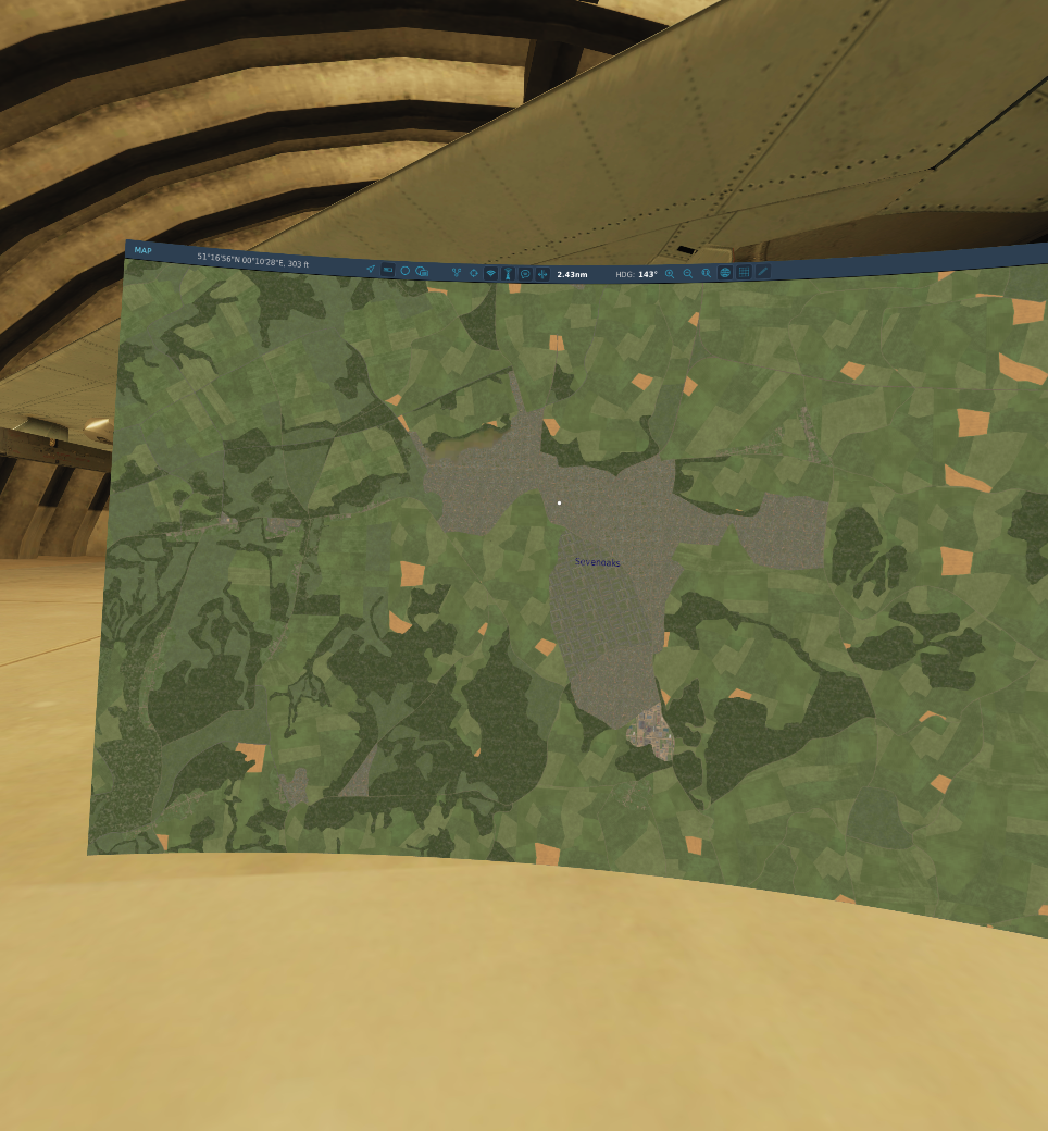
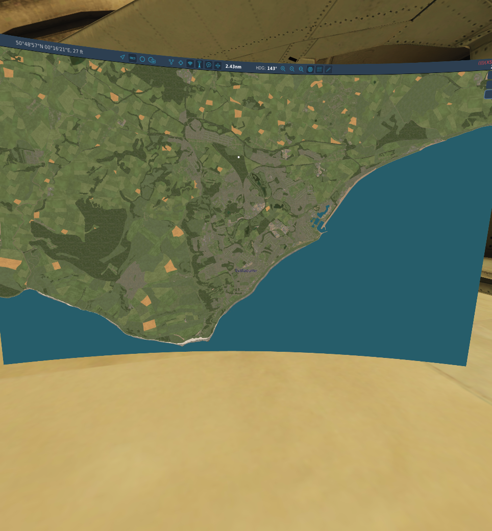
Hi ED, It appears that either more modern maps or data have been referenced when creating some of the towns in the Southeast England portion of the map. Sevenoaks and Eastbourne are two such examples: Sevenoaks in 1940: And on the DCS map: Eastbourne in 1940: And on the DCS map: Be nice to see these conurbations reduced to a size more in keeping with the time period; it might help save a few frames or too also! Also it should be noted that a railway line from the North that currently terminates at Sevenoaks should actually continue through a series of tunnels and cuttings to join the railway line at Tonbridge. It looks like this has been mistaken for a road on the DCS map.

-
-
Bewl Water is an artificial reservoir located 10 miles East of Crowborough and 7 miles Southeast of Tunbridge Wells: Bewl Water - Google Maps It was created in 1973. It is however in evidence on the DCS: The Channel map. Could we get this feature removed as it is obviously not appropriate for the time scale represented by the map.
- 1 reply
-
- 2
-

-
Please add Canterbury Cathedral to the map: 3D Model: Canterbury Cathedral | 3D Warehouse (sketchup.com)
-
RAF Kenley actually falls just outside the western limit of the map unfortunately. It may be instead that we see it included as part of the expansion of the Normandy map; keep your fingers crossed but don't hold your breath... I agree the cathedral at Canterbury is notable for it's absence, and as unique landmarks go, it should really be included. However... You have to be careful asking for the inclusion of lots of one-off features - there's economy in utilising a library of more generic structures to make the map, it's not only easier to develop but also serves to keep system demands reasonable for the average user; add too may unique structures and the tax on the average system will become too high, so there's a balance to be struck. Regards additional airfields on the continent; agreed but choosing the right ones is also important. The map seems to represent a period covering late winter/early spring 1943-44. By this time the majority of the fields near the coast were not operational; most had been abandoned and either mined and obstacled or had only the bare minimum ground echelon to caretaker the field should it be needed in the future. The majority of the fields occupied by the Luftwaffe were closer to the French German border, or further East in Belgium and Holland. This reflects: 1. The Jagdwaffe's increasing focus on Defence of the Reich operations, it's reaction to the 8th Air Force's strategic bomber raids on Germany proper. 2. The Jagdwaffe trying to increase the time allowed it's interceptors to climb to altitude to attack with some height advantage. 3. The Luftwaffe trying to conserve it's forces from snap fighter-bomber/medium bomber attacks on it's forward bases. Again these prototypical fields are mostly - but not all - currently East of the detailed map area. One hopes that any future expansion might push them to be included.
- 1 reply
-
- 1
-
-
In every other module that is correct; however Heatblur decided it’s such a fundamentally important feature of the flight model experience in their eyes, it’s on permanently in the F-14.
-
Link has expired. New information: Atlantikwall.co.uk
-
RAF Needs Oar Point advanced landing ground
DD_Fenrir replied to Fred901's topic in DCS: Normandy 1944
Some links have expired. Update: RAF Needs Oar Point ALG (atlantikwall.co.uk) -
Quoted for truth. This too.
-
"Wake Turbulence" is always on for the F-14, regardless of the global ED setting.
-
This map looks great but I feel like a chump for buying it.
DD_Fenrir replied to Tree_Beard's topic in DCS: The Channel
Scale in distance maybe; but that’s not the limiting factor for DCS. It’s far more related to object density. Some of the largest maps can be that big because, aside from a few big cities, there are not a lot of objects in the terrain between them. This is not the case with Northwest Europe and both Normandy and the Channel map, each had performance issues to start with and required heavy optimisation to get to the state they are now. The Channel has several orders more level of detail than Normandy and will require much more careful development if it is to be expanded. Your request would require approximately 20x the current area - a lot of it sea I grant you, but also almost the entire East coast of the UK and the large number of industrial towns therein, not to mention 50 odd airbases. That’s before you even deal with the continent. I don’t believe any current computer could load and run it, especially when you start adding mission targets, AAA and AI aircraft. Syria also has draw distances much lower than other contemporary maps to compensate for its size so you need to be careful what you wish for. -
This map looks great but I feel like a chump for buying it.
DD_Fenrir replied to Tree_Beard's topic in DCS: The Channel
Hahahaha! I admire your optimism there chum. -
No official response. We can only hope that the planned expansion of the map might bring the necessary revisions (plus some additions) to all the airfields on the English side of the map.
-
Even since the acceleration of DCS WW2 development we have seen approx. 1x WW2 flyable model per year, even if you take the most likely candidates you're looking at 31 years for that list! Plus I can guarantee there is insufficient data out there to model a great deal of those to DCS standards; where possible they like to have a real flyable equivalent to get reliable feedback from pilots on handling characteristics, and if not, a veteran with exceptional presence of mind and recall (exceptionally rare) to provide the same . This requirement alone immediately excludes a lot of those you ask for. Then there's wind tunnel test data, or even just basic data on the aerofoil shapes; not just of the wings but the propellers too; even the Western nations where stuff was generally very well documented, there are gaps, even in the popular types, particularly the German aircraft where a lot of documentation was destroyed or lost. Japan? There's a reason that not many modern high fidelity simulators have a WW2 Japanese type flyable currently. If I were you, I would mange my expectations somewhat..
-
DCS takes the simulations too literally to be fun or practical.
DD_Fenrir replied to gotit's topic in New User Briefing Room
The greater question is then... why are you even here? Surely this an issue with all high fidelity simulations? You're not finding it fun? Ok. Different stokes for different folks. You don't get to tell me what I find fun - correction - what I find edifying. The challenge brings me back to DCS repeatedly; the lack of true physiological effects is simply an inherent issue to the platform. This is entertainment software for a PC platform. It comes with the territory. You can fire the same issue at sub-sims; 1st person shooters; driving sims; any number of entertainment genres where physicality is a missing element. DCS allows me - within the restrictions of the platform - to simulate flying combat aircraft I could never even afford to climb aboard in real life. The lack of physiological effects is just the compromise that comes with the affordability. You accept that and enjoy the other elements.- 96 replies
-
- 37
-
-

-
Trouble being as Ironmike has already explained is there is virtually no useful data on what the differences between the A and the C are and how this manifests in performance; yes the C is solid state but what tangible changes did that bring? We hear some tantalising hints on interviews about improved guidance and better ECCM but there are no figures to reference, either for the A to improve upon or for the C to confirm. It’s a guesstimate.
-
Hey man, fresh to this. From an outsiders perspective you've done yourself no favours. You have requested advice. It's been given, fairly evenly and accurately I might add. The only thing that has irked people round here is the attitude you give back. There is no secret move. There is no elitist conspiracy to keep you from tanking the F-14. Everything you have read is correct and has to be used in a combination you find most efficient but you gotta put the hours in to find that sweet-spot. It will click, at some point, but that time can vary. There's a rhythm to AAR that cannot be taught, you have to see it and feel it.
-
Be careful here - it could very much depend upon whether the incoming targets were skylined or not.
-
I have updated the 2nd post after doing some testing.
-
Methinks some peeps be under some misapprehension… DCS =/= Ace Combat
-
The former (highlighted).
-
BUMP
-
The Drem lighting system showing the standardised lighting patterns for an RAF airfield: The "WHITE FLOODLIGHT" referenced to the lower left of the runway is the Chance Light, a floodlight to illuminate the runway in case of an emergency. The runway and taxi-ways were marked with Glim lamps - the light from these was masked such that the illumination could only be seen from low altitude, at circuit height. These were backed up by parafin goose neck lamps in case of failure: Obstruction & Marker lights I am still determining the form factor of the outer marker, funnel, totem and dumbell lights.