
gulredrel
-
Posts
1365 -
Joined
-
Last visited
Content Type
Profiles
Forums
Events
Everything posted by gulredrel
-
Cool, thanks. Haven't been there yet. A bit too far away for a short trip. Many industrial complexes here in the vicinity have been modernized or are completely gone with no larger structures left.
-
Regarding the water towers, yeah, a bit too many I guess. Here some real world examples some km away from me. Took the bike between the rainy showers. Haven't really seen such a steel construction like the green ones in the map. Those that I know of are brick build at the bottom. But the have been reused an can have pointy roofs, not always round, but pointy. Was / is used for wedding ceremonies and some art exhibitions. There are some placards at the gate made of the steel used for the water container with was in there. And a second one which is next to a train station which has not been converted to a house. Some details from the top.
-
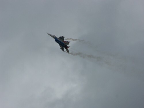
Some low level flying near Stendal.
-
Not a big deal flying high, but would be great to have separate firetrucks and ambulance vehicles in East Germany. Currently you will find the following western Firetrucks and Ambulances in the east (based on Magirus Deutz(? at least I guess this is based on) and VW): For immersion you would want to have Firetruck based on IFA W50 (https://de.wikipedia.org/wiki/Tanklöschfahrzeuge_in_der_DDR#TLF_16_(IFA_W50_LA)) and Ambulance based on Barkas B1000 (https://de.wikipedia.org/wiki/Datei:B1000-DMH.JPG or https://de.wikipedia.org/wiki/Datei:Barkas_B_1000_SMH_3.jpg) in the east. Thanks
- 1 reply
-
- 1
-

-
Shold the wheels feel so "slippery/greasy" on landing?
gulredrel replied to RyanR's topic in DCS: Mirage F1
There is a guarded nose wheel steering switch (yellow and black stripes) next to the NWS high sensitivity button on the central panel. Guard cover open and you can now enable or disable NWS completely with this switch. -
Taking opportunities east of Fritzlar... And back to Spangdahlem.
-
Okay, that explains a lot. That tower building is really looking great.
-
Why is Damgarten looking this way for you!? This is my view in the same location regarding the coordinates...
-
Water depth sea's to and in ports not deep enought
gulredrel replied to Mac D's topic in Bugs and Problems
I already reported this. It's all along the coast and even between islands where the water isn't deep enough for ship placement and routes. This will be hopefully fixed in the upcoming iterations of the map.- 1 reply
-
- 3
-
-
From Fulda to the north along the border line a little border violation
-
Cold War Sale | Currenthill Assets | Contention PVP Servers
gulredrel replied to Graphics's topic in Official Newsletters
Exactly my first thought. Excellent news getting more AI assets into DCS core. Thanks Currenthill for the collaboration. -
Mi-8 cockpit pilot's red lights lighting texture issue
gulredrel posted a topic in Bugs and Problems
There is a problem with the Mi-8's left cockpit red lights knob group 1 or 2. If you turn them on to low or medium intensity, there is a weird texture on the panels. See these screenshots: Knob in off position okay: knob slightly turned on, panel texture grey reddish pixelated: knob further turned on, panel totally pixelated, less grey: knob max okay: Depending on the outside lighting conditions this looks even worse. See also track attached where it was clearly visible. This will not happen with the right copilot's red lights. Thanks Jens 20250425_Mi-8_pilot_red_panel_lights_issue.trk- 1 reply
-
- 2
-
-

-
There was also a base in Dresden Hellerberge https://www.mil-airfields.de/deutschland/flugplatz-dresden-heller.htm Location of the harden surface is still visible https://maps.app.goo.gl/6REzjfHghQ9fA1yGA
-
No native implementation yet. You can use the file from this thread at least in single player:
-
10 GB for me... I have no clue...
-
So here some more details. Will also change summary. Depth 5 m ships can be placed here at Rügen Sassnitz: Bit closer to the harbour the water is only 4 m deep and ships cannot be placed. This is also the cause between Rügen and Ruden island. Only 4 m of depth and all the other ports in the Baltic (Rostock, Wismar...). Same is on the coast of the North Sea. Water too shallow. Esturary of the river Elbe (Elbemündung) is too shallow. Marked in green it's 5 m or deeper until the point marked with the ship. From there it's only 4 m deep (red marking). In Hamburg city the harbour is deeper than 4 m and ships can be placed there (again green marking). Hope this helps changing the harbours and coastline water levels to at least get some patrol boats going out and in from the harbours where these patrol boats were stationed and also getting larger ships in and out to Hamburg, Rostock as they were large oversea ports for supplies and so on. Thanks Jens
-
@NineLine Could you please merge both threads? Will try to add some more details later, maybe it's a general thing on the Blatic Sea's coast.
-
Ah, sorry, haven't looked for others reports. Yeah, threads should be merged. Is there a known moderator in Ugra subforum or do we need to ping Bignewy or Nineline? Anyone checked the other Baltic Sea ports in Warnemünde, Rostock, Sassnitz, Wismar etc? Or is it a general thing?
-
Hello, looks like the water near Peenemünde is too shallow. Wanted to place a Class 1241 ship inside one of Peenemünde's harbors but the message "insufficient depth" occurred. Following screenshot shows possible unit placement. Can't move the object further to the coast or even inside the harbor. Ships also cannot be placed between Rügen and Ruden (the small island north of Peenemünde). The two ships mark the border east and west of the no go zone for ships: Thanks Jens
-
I DON'T own Kola map but own F-4 and the patch size is about 10 GB download for me Looks like there are some things missing in the changelog?
-
Ugra ground object in CW Germany map. Maybe... someday...
-
Just my two cents. For me it's a great mix between authenticity and some artistic interpretation. Yes, there could be a ton more iconic building in Berlin or elsewhere Schloss Bellevue seems to be missing next to Siegessäule, but there is still a ton of different generic buildings. With the amount of space that Phase 1 uses, I'm totally fine with the balance Ugra found. Maybe they will add some more iconic places. This will be even better, but from what I've seen, it's great for what it's meant to be. Was following Berliner Ring motorway and than B1 into the town. No problem following the road like my uncle did in the 80s with his Trabant until arrival at / near Alexanderplatz. This kind of building with the gravel mix with concrete facade is beautifully recreated: Looking forward to phase 3. Looks like construction work has begun at Bautzen airport, there are some roads and fences already present in Saxony.
-
Took the Mi-8 from one of the easter heliports in Berlin around the city. Awesome. around Rotes Rathaus Sneaking around Palast der Republik Unter den Linden (zoomed in to the trees, no Linden tree, literally unplayable *lol* joking) Siegessäule Landing at Berlin Schönefeld.
-
Looking awesome, thank you. As I understand the MiG-21 system is independent of the map's beacons.lua and changes there will not interfere?! Tarres and me edited the original beacons.lua in CW map to have at least RSBNs for L-39 usage, see here for the folks interested:
-
just for the sake of completeness. Setting PRMG LOC and GS to 838MHz for Laage works: