gulredrel
-
Posts
1365 -
Joined
-
Last visited
Content Type
Profiles
Forums
Events
Everything posted by gulredrel
-
Peenemünde outer and inner NDBs are also coded in the MHz range instead of kHz. Garz ILS arrow is also pointing to one of the markers instead onto the runway. There are many nav aids to be revisited by Ugra. But we all know: EA is EA and we all know the risk of being the forerunners wanting to use it. But Syria evolved nicely so I'm confident this will be the case too with CW Germany.
-
Just did a quick test with Laage PRMG GS and LOC definitions and set them to 938MHz leaving the channel at 38 as it is in there. This didn't work. In Caucasus beacons.lua the PRMG frequencies and channels are in 800MHz range like RSBN. I've no clue how the L-39 system works. Is it just looking for the channel regardless of the frequency?!? Maybe later there's some more time. Currently thankful enough to have the RSBN working. Won't set fog and clouds to not see anything in the next time. Enjoying the map and have basic navigation aids for L-39 is currently sufficient.
-
Haven't found these landing craft yet in ME. Could you please tell the coordinates?! Or distance and bearing from an nearby airport? edit: Never mind, found them going along the coast. Near Wismar north of H GDR 17. Nice pics.
-
RSBN stations were placed on artificial hills for better coverage. In Laage it's placed on such a hill. Maybe they forgot the hill object below but edited the height above ground for the RSBN object as elevated.
-
In the meantime I've edited the file and put the display names in for convenience: I used this site https://www.mil-airfields.de/de-rpt/ddr-funkfeuer-rsbn-de.htm and google maps where I looked for the coordinates (positionGeo) from the beacons.lua to double check. I also changed Zerbst frequency / channel to 17. beacons.lua SC is a strange one. There are two entries, 'airfield166_0' and 'airfield166_3' west of Fulda. GDR spies must have placed a RSBN station there!?
-
Thanks, I'll give it a try. Not IC compliant is no problem. Only doing SP. Edit: Thanks @Tarres works like a charm. Much appreciated. Damgarten worked, tuned Laage right after takeoff: Tuned Peenemünde: Approaching Laage, RSBN station is to the right of RW10, perfect: Compared the original beacons.lua and your example in notepad++. Should be not such a great deal for Ugra. Mostly missing callsigns and frequencies. It's just "Fleißarbeit", as we say in Germany Beacons are already placed.
-
Is there a list for L-39 channel and RSBN frequ. which I can use with the help of Caucasus beacon definition? Would like to add some stations for L-39 flights until an update is available.
-
This will hopefully be sorted out. Was also looking forward to do some flying in L-39 using the RSBNs for navigation.
-
Many places with German Umlaut. Peenemunde should be Peenemünde or at least Peenemuende to avoid the Umlaut at all. Larz -> Lärz -> Laerz Kothen -> Köthen -> Koethen Furstenwalde -> Fürstenwalde -> Fuerstenwalde Lubeck -> Lübeck -> Luebeck Grevesmuhlen -> Grevesmühlen -> Grevesmuehlen Buckeburg -> Bückeburg -> Bueckeburg Zweibrucken -> Zweibrücken -> Zweibruecken Bad Durkheim -> Bad Dürkheim -> Bad Duerkheim and many more I think. I guess, these may be also written wrong on printed non German maps in the past. So it's just a minor inconvenience. If there was an easy way to export, change and import the names, this would be a valid task. But I don't think it be a quick fix, so UGRA should better concentrate on fixing real issues (Would love to get working RSBN/PRMG for L-39)
-
Just a little thing, the is a Dash 60 starter cart parked at Damgarten. These shouldn't be present in the East
-
- 1
-

-
Yeah, also struggled with this. Did my first flight in L-39 and was not able to tune a RSBN station. Some channels are marked in the map in ME or F10, but this didn't help. Also not all airport NDBs (far/near) are working. Couldn't get a signal in Peenemünde but Garz (Heringsdorf) was working ok.
-
 Currently we are in early access phase 1. As far as I understand it will be 205 GB in phase 3 with all the other airports and areas added. There's a map in FAQ showing roughly the boundaries of the phases.
 -
Back from my first flight. Awesome. Just did a tour from Peenemünde, norther east Germany around Rügen and back in evening lighting conditions. Need to fly down low in Mi-8 but the villages and cities looked awesome.
-
Thanks Ugra. Awesome map. First flight in the L-39 from Peenemünde, Heringsdorf, Laage, Rostock, Damgarten, Rügen and back to Peenemünde. Airfield details are really nice. No need to populate with static objects in ME to get some life in there Bunkers of type "Granit" used as "Sonderwaffenlager", storing nuclear warheads.
-
Shold the wheels feel so "slippery/greasy" on landing?
gulredrel replied to RyanR's topic in DCS: Mirage F1
NWS set completely to off at takeoff/landing for me too to avoid that oversensitive steering issue. Ground physics in general are a bit weird in DCS. Sticking in the grass next to the taxiway and the need for AB to get moving from there. Or the helicopter skids being glued to the tarmac and stopping almost instantly during a run on landing where the helicopter should just skid forwards. -
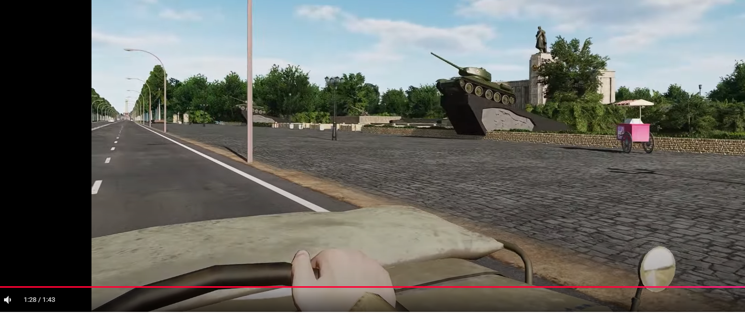
ah, yes... the monument with the T-34s which was in West Berlin. That got me puzzled when I was a kid and didn't know the circumstances leading to this.null

-
RSBN at East German bases... let's warm up L-39 in, at least I hope it's compatible with the L-39 like in Caucasus. Have to wait until Phase 3 to get my nearest airport which housed L-39 back than.
-
*bump* April 2025 With the Germany map on the horizon, towing capability would be awesome to populate the map and have some logistics targets / moving columns. @NineLine Is there any news on that? I really like the ground assets which were updated or added in DCS core in the past like the Ural-4320T, Ural-375 or the ZIL-135. Refueler tractor vehicles TZ-22 and TZ-60 are in game, encyclopedia shows non existing tank trailer objects.
-
Including Nelson Piquet and Alain Prost tank drivers? 1982 - 1991 layout, wiki link:
-
Amazing thing...
-
This is getting better and better...
-
@MAESTR0 Would like to know if there have been some historical sights or monuments implemented already like Kyffhäuser Denkmal or Wartburg in Eisenach in central Germany?
-
Matches perfect with KarlRadek's post above. Thanks for showing more and more details. Let's drain the lakes around Leipzig and make the open-pit mines they were in the 80s.
- 484 replies
-
- 10
-
-

-
@KarlRadek Thanks for pointing this out and hopefully Ugra can use these valued input to improve the map further. Currently living in the Phase 3 zone and being able to have three of the remaining power plant's cooling tower clouds in viewing distance. Looking forward to recreate this incident due to my lack of flying skills concerning the MiG-21: http://www.lausitz-bild.de/cottbus/panoramen/flugzeugabsturz1985/flugzeugabsturz1985.html https://www.zdf.de/play/dokus/vor-50-jahren-flugzeugabsturz-in-cottbus-movie-100/jubilaeum-militaerflugzeug-absturz-cottbus-100
-
Autopilot - BALT and RALT cannot be engaged
gulredrel replied to ggerman2862's topic in Bugs and Problems
Got this today in same mission when I was unable to set SEQU1 to AUTO. I thought it had something to do with having flown a mission on a different map in the same DCS session before. I I tried to replicate but it worked in next missions I loaded in new DCS session (both AUTO sequence and BALT mode). Strange behaviour.