Holton181
-
Posts
1630 -
Joined
-
Last visited
-
Days Won
1
Content Type
Profiles
Forums
Events
Everything posted by Holton181
-
Excellent! Thanks. Would it be possible to add a elevation resett button to quickly return the elevation to default? This would not work if an elevation axis was added and assigned though.
-
Thanks for this corvinus! As a matter of fact, I played your highway landing mission in the Viggen training package yesterday night, and I experienced something fitting your findings. While positioning myself for the landing flying low over the nearby hills, I turned on PPI and then TAM. To my surprise I got good returns of the hillsides in front of me (without touching anything else). To see if the angle was different than in my own missions I turned TAM off and swished to AKAN, but the indicator was at the same original position. Turned TAM back on, and now it was basically all empty. I didn't try to leave AKAN mode, I didn't know that mode are supposed to change the elevation. It was late so I went to bed and planned to investigate further when time permits. But you beat me to it. I will try my own mission again with this in mind. But now a few questions arised: How do we know the radar elevation if the indicator only appears while in a weapon mode that changes the elevation? More important, how do we know we have it in its default setting if we have done some adjustments before? Since we don't have an authentic potentiometer with a detent at the correct position, are we forced to turn to AKAN mode, adjust the elevation back to default (for AKAN) and then turn back whatever weapon mode we had? Quite tedious and not very user friendly if one like to switch back and forth between a ordinary radar with adjusted elevation and TAM (maybe not how one should use it in the first place, but still). Also, if it is a correct behavior of the elevation to change when turning to say AKAN, it needs to be mentioned in the manual. Maybe it is somewhere already (haven't read it completely yet to be honest), but it is not in the section about the TAM.
-
** UPDATE: Ground Radar 2.0 & Multiplayer Flight Planning **
Holton181 replied to Cobra847's topic in DCS: AJS37 Viggen
Yes I know that, but I'm not interested in the overall shape of the lake, only that landmass (wrong spelling before, sorry) below B3 going out in the lake, clearly visible for the pilot and in line of sight for the radar. -
** UPDATE: Ground Radar 2.0 & Multiplayer Flight Planning **
Holton181 replied to Cobra847's topic in DCS: AJS37 Viggen
Yes, I understand that the radar needs line of sight and should not give information about things behind obstacles. That part is much better, thanks. But my problem is different. If you look at the first picture in post #142, the ocular view (or whatever I should call it), you can see it has line of sight of that particular part of the lake I'm interested in, the beak straight below B3 and perfect for a radar fix (I'm not a native English speaker, "beak" is the best word I found for what we Sweeds call an "udde", that small land mas stretching out in the lake). When using LIN I do get a good picture (after some tricky, sensitive adjustments of the elevation using only buttons since no axis can be assigned), but in LOG it's basically impossible, especially for B-scope. You did get a return showing the beak in post #148 (but it was very washed out and hard to see), I guess it was maybe due to slightly different location/altitude than in my examples. Now, I don't know enough about radars to say that this issue, if an issue at all, is wrong or realistic, it's just that I get the feeling that on this distance (10km), elevation difference (about 400m) and line of sight, a better and more clear picture in both LIN and LOG mode should be possible, with less hassle with the elevation (i.e. in a wider range). Never since the introduction of DCS 2.x I have been able to use that B3 as a radar fix point while actually flying (no active pause), well in no mission actually, while in 1.5.x it is very easy. I do believe the Ground Radar 2.0 will make it better and easier overall, but I really looked forward to be able to use that B3 again... ;-) -
** UPDATE: Ground Radar 2.0 & Multiplayer Flight Planning **
Holton181 replied to Cobra847's topic in DCS: AJS37 Viggen
Here they come. Nothing changed unless otherwise stated. All settings default, radar gain on axis assignment max. All settings default, radar gain not on axis assignment. All settings default except gain, on max with keys, radar gain not on axis assignment. All settings default, radar gain not on axis assignment, July same time of day and "summer clear sky no wind" weather preset. On all above I had about 25 FPS while heads down on radar screen. I also tested to turn off the mirrors, increased FPS to around 35 but did not have any effect on the image. Turning to summer had basically the same effect as turning up the gain slightly, and also increased the FPS a bit. All game settings and modification to the miz file was followed by a DCS restart. LOG mode still not really usable in this situation while perfect in 1.5.7. My conclusion on the Radar Gain with axis assignment problem is that I don't seem to have it? When I have it assigned to an axis my default gain is the same as if not assigned to an axis and tuned up with key commands. And my lowest gain axis setting result in a completely blank screen, same as for keys only. Both missions I have used for the tests are attached. I did test the "Rocket Attack" mission, same modification procedure as with Interdiction (filename explains it all): The default seams to be usable here but more washed out than 1.5.7. The missions for 2.5.3 are attached. EDIT: When I talk about "usable" in this context, I refer to nav fix situations, not target acquisition. Interdiction radar test.miz Interdiction radar test summer CAVOK.miz AJS-37 Rocket attack radar test.miz AJS-37 Rocket attack radar test 10km.miz
-
It's not about realistic scenarios/conflicts, it's all about realistic places with realistic geography and with real information, of various kinds, from various sources other than the Eagle Dynamics univers. A lot of examples given by many of us so called Naysayers. And I myself would really like to visit Georgia for its said geography, mountains, valleys, the Black Sea etc, and that is only because I have flown there in DCS.
-
** UPDATE: Ground Radar 2.0 & Multiplayer Flight Planning **
Holton181 replied to Cobra847's topic in DCS: AJS37 Viggen
Ah, much better ;-) And that is in LOG if I understand correctly, with default gain and elevation? Looks quite much better than for me, even though the deak isn't that pronounced (have access to a computer for better view, even though I now use tapatalk on my phone). I can't make the break visible in LOG whatever I tried, in LOG I succeed but after quite careful adjustments of the elevation (tricky without an axis), careful to a level not practical in NOE M0.8 and above. Can't really use it for nav-fix in that mission. B3 was perfect in 1.5.7 for that purpose. Will try again (tomorrow evening or the next day) with the axis assignment of the gain removed, but I have low expectations. Stay tuned! -
** UPDATE: Ground Radar 2.0 & Multiplayer Flight Planning **
Holton181 replied to Cobra847's topic in DCS: AJS37 Viggen
That doesn't look like Interdiction? No winter, no low overcast clouds and no beak in a lake. What you have there is more like a island peak in a river. And you are way to high. I mean the Interdiction Wags played a few years ago: -
** UPDATE: Ground Radar 2.0 & Multiplayer Flight Planning **
Holton181 replied to Cobra847's topic in DCS: AJS37 Viggen
I will try that "Rocket Attack", but I assume it's without snow? Other missions during no-snow seasons seem to be quite OK. I will also try my modified Interdiction but with changed season and weather and see if it makes any difference. Could you return the favor if time permits and try Interdiction? Unfortunately I'm not at home so I can't share my modified that start in active pause at that exact position as my pictures (10km before B3 at 400m AGL). Just to be sure, when you say my gain seems off, you are talking about the lower image in each picture, the 2.5.3 one, right? Yes I have an axis assigned to the gain, the throttle lever on my Saitek Evo. It's in the highest (default) setting for all LOG pictures, in LIN I reduced the gain slightly. I have seen others with issues with it and have tested to remove the axis assignment but could not really see any difference. But I will try it again on this test mission. By the way, regarding the elevation, even if a bit off-topic, I hope you have some input on this: https://forums.eagle.ru/showthread.php?p=3714948 -
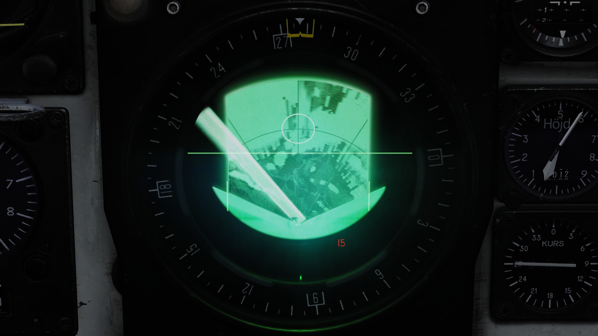
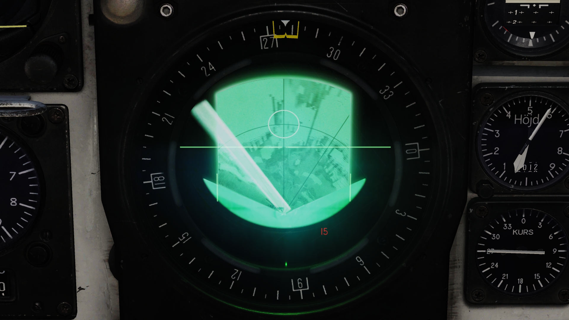
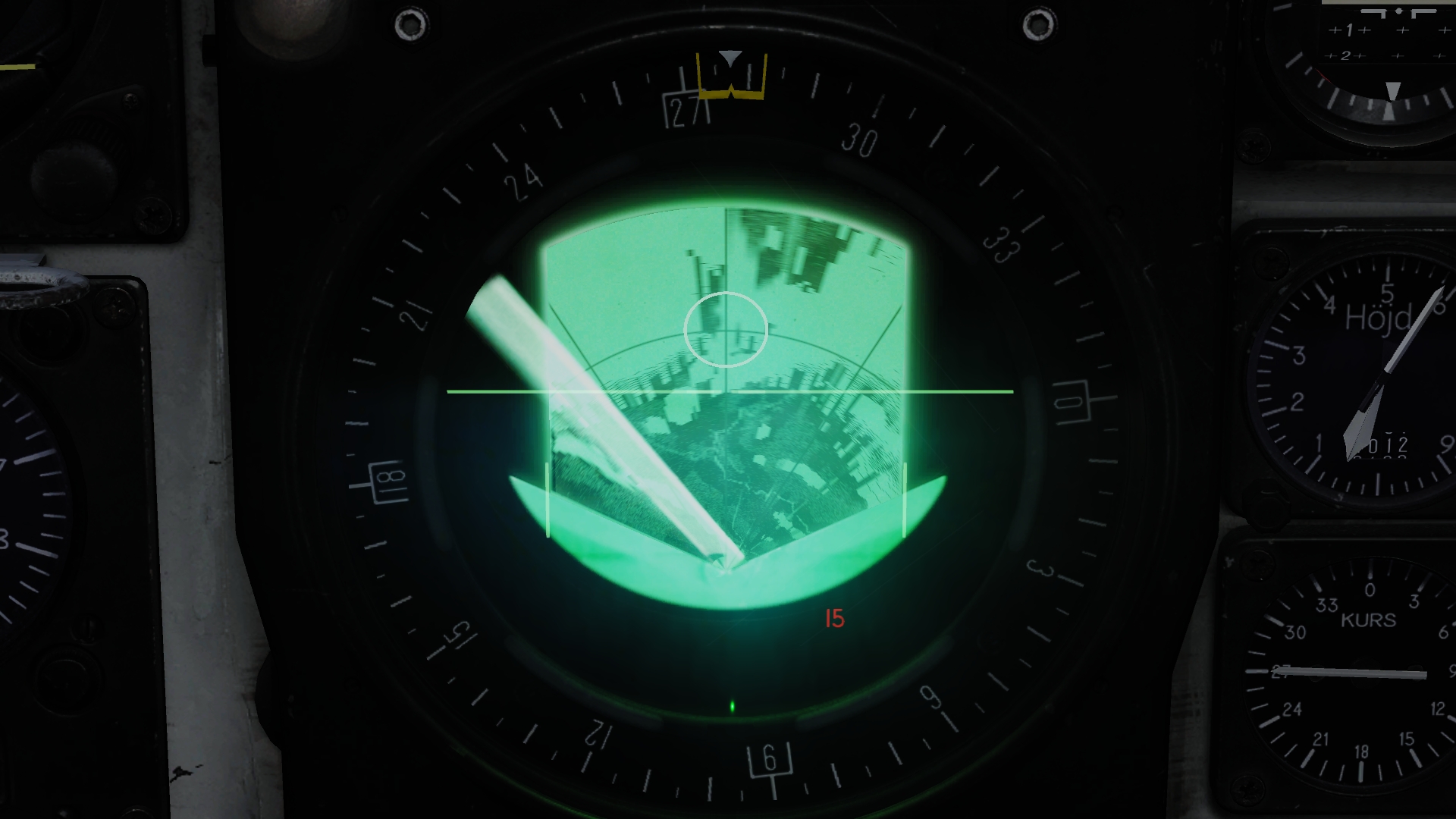
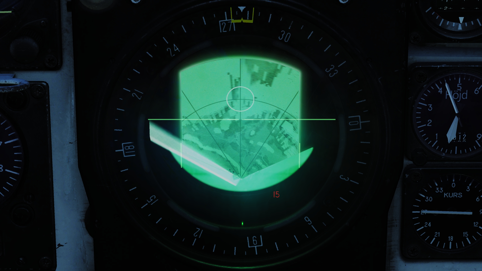
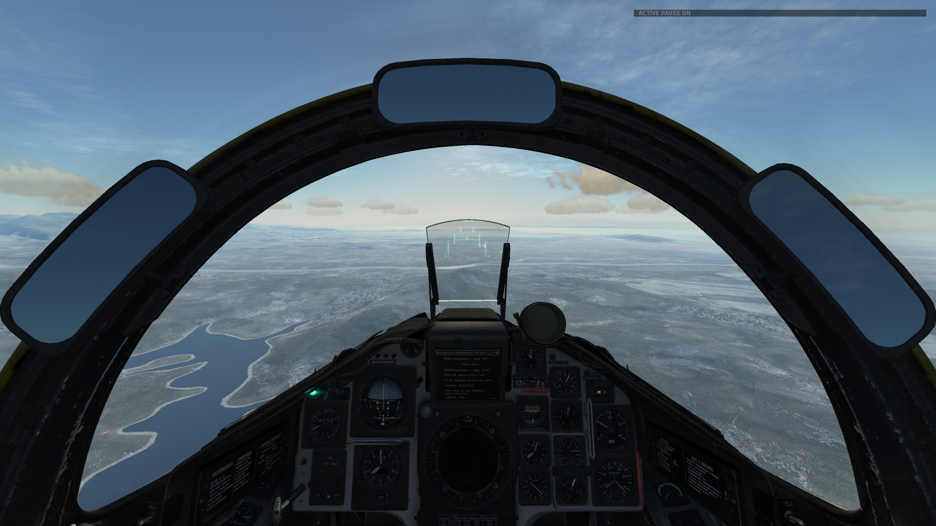
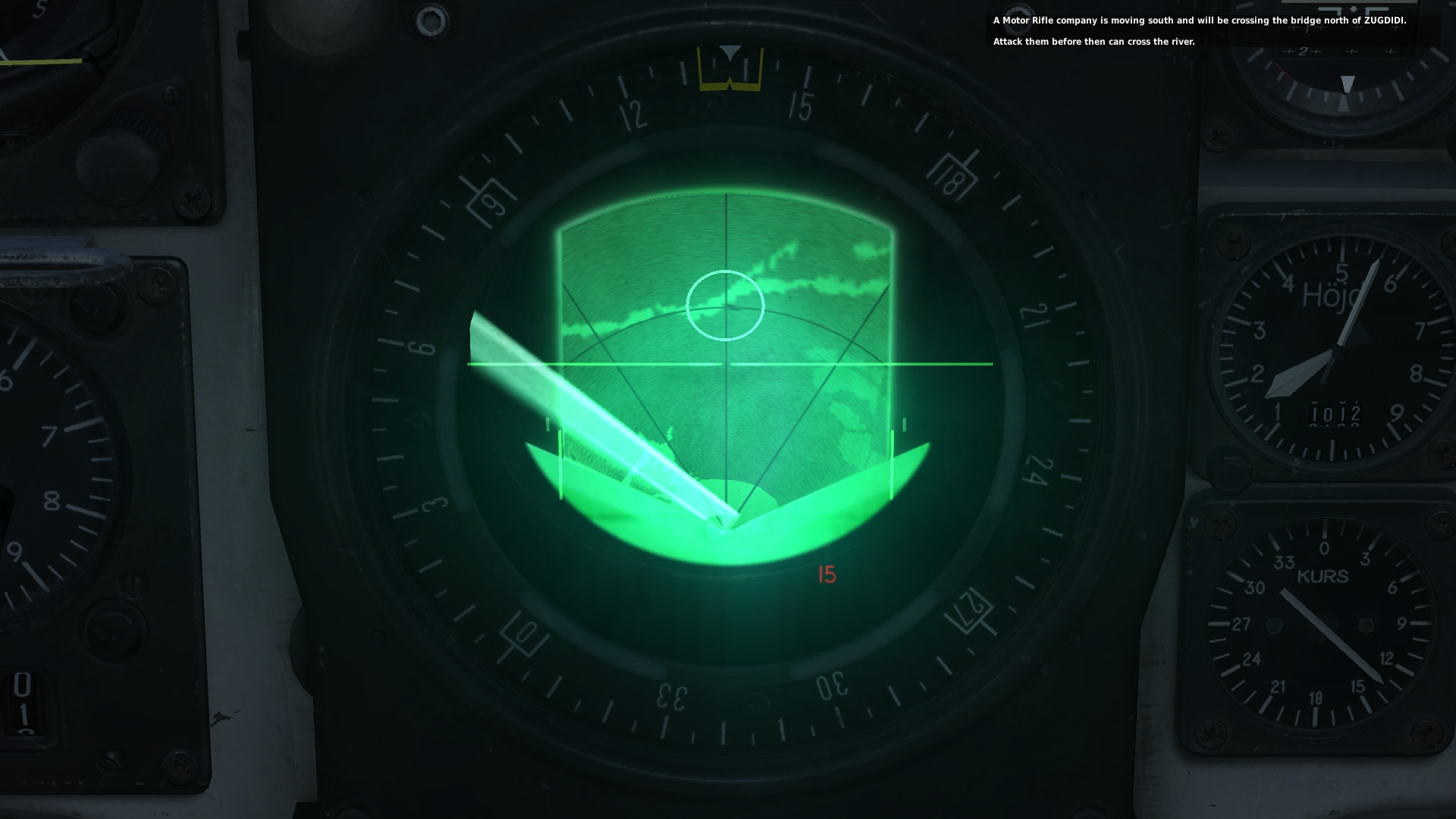
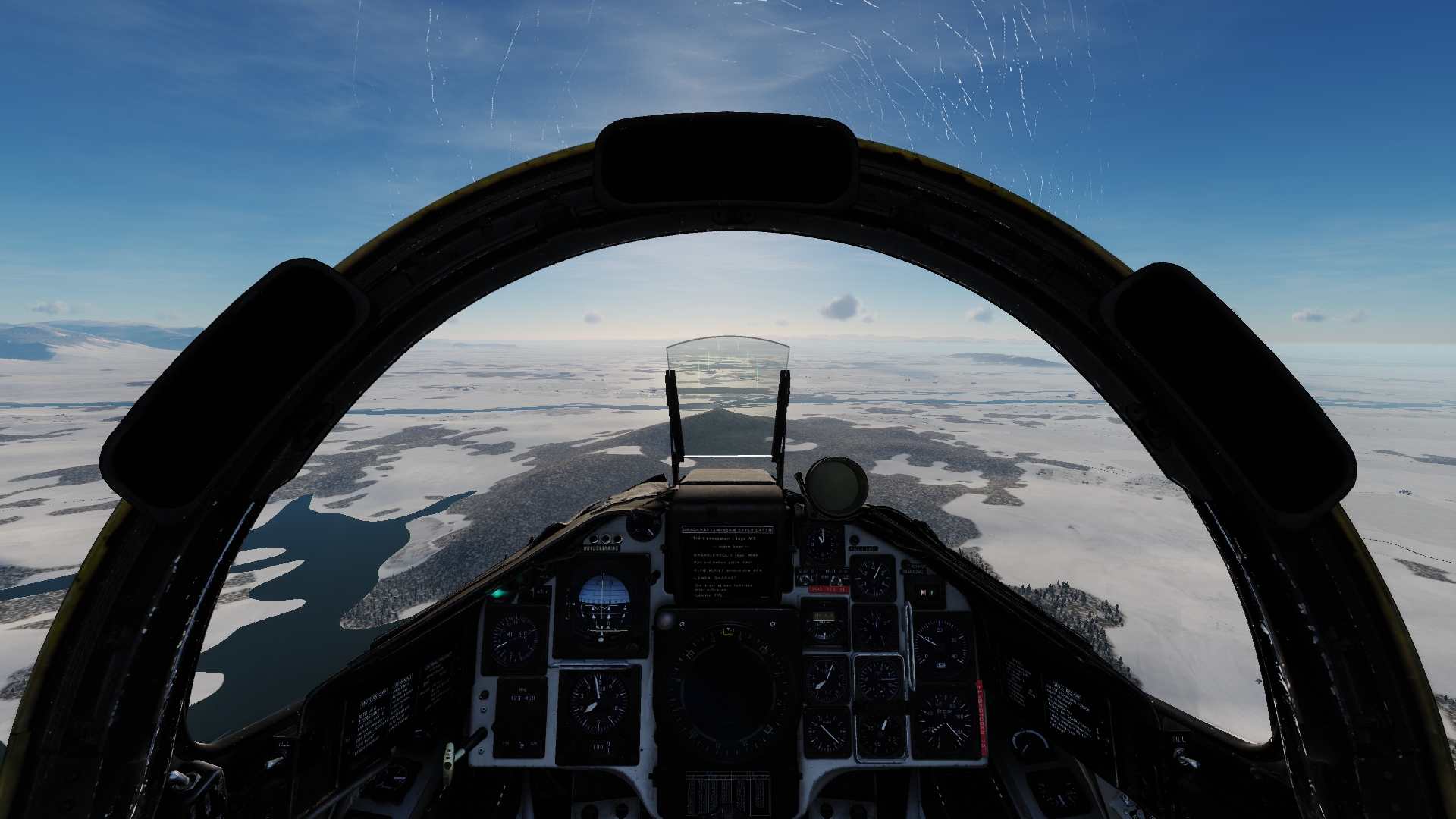
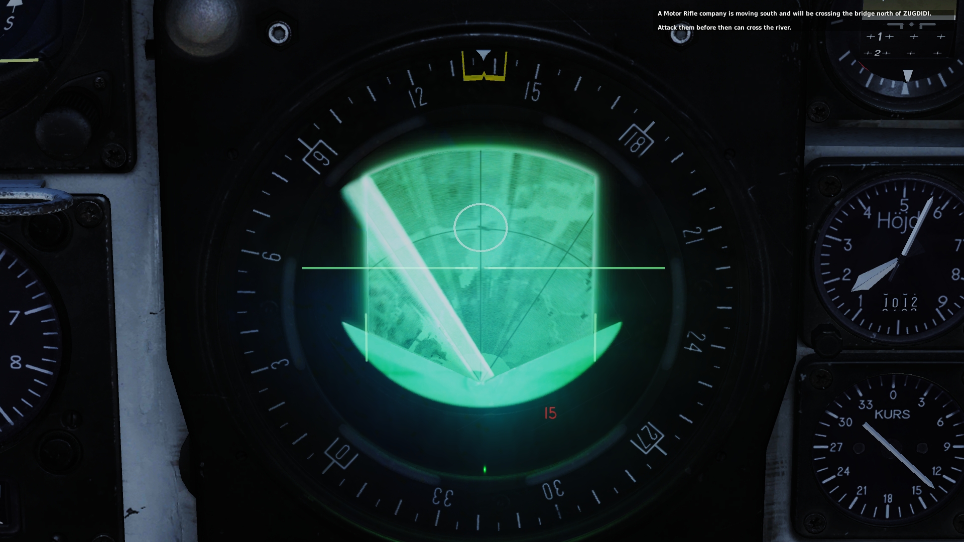
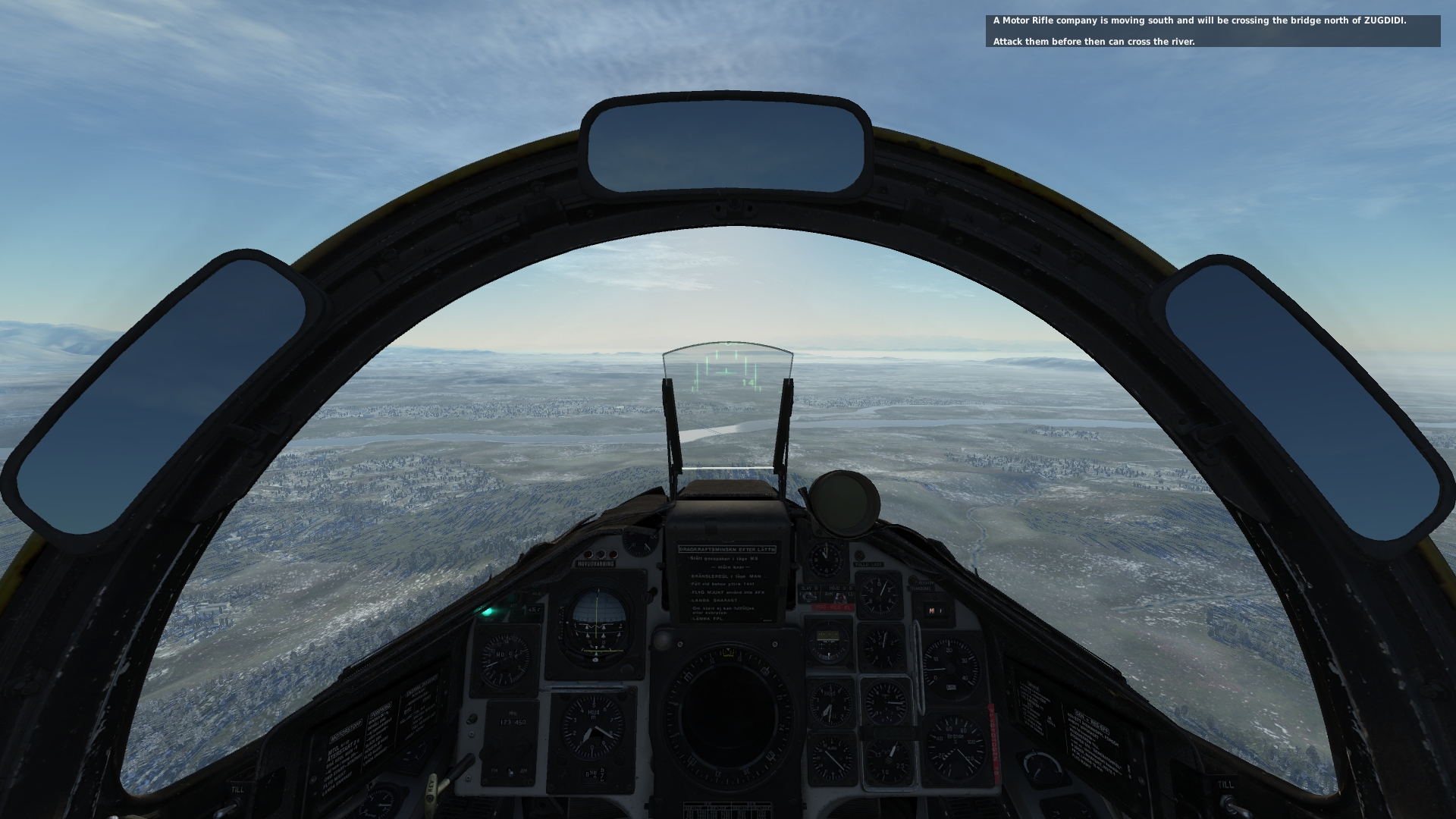
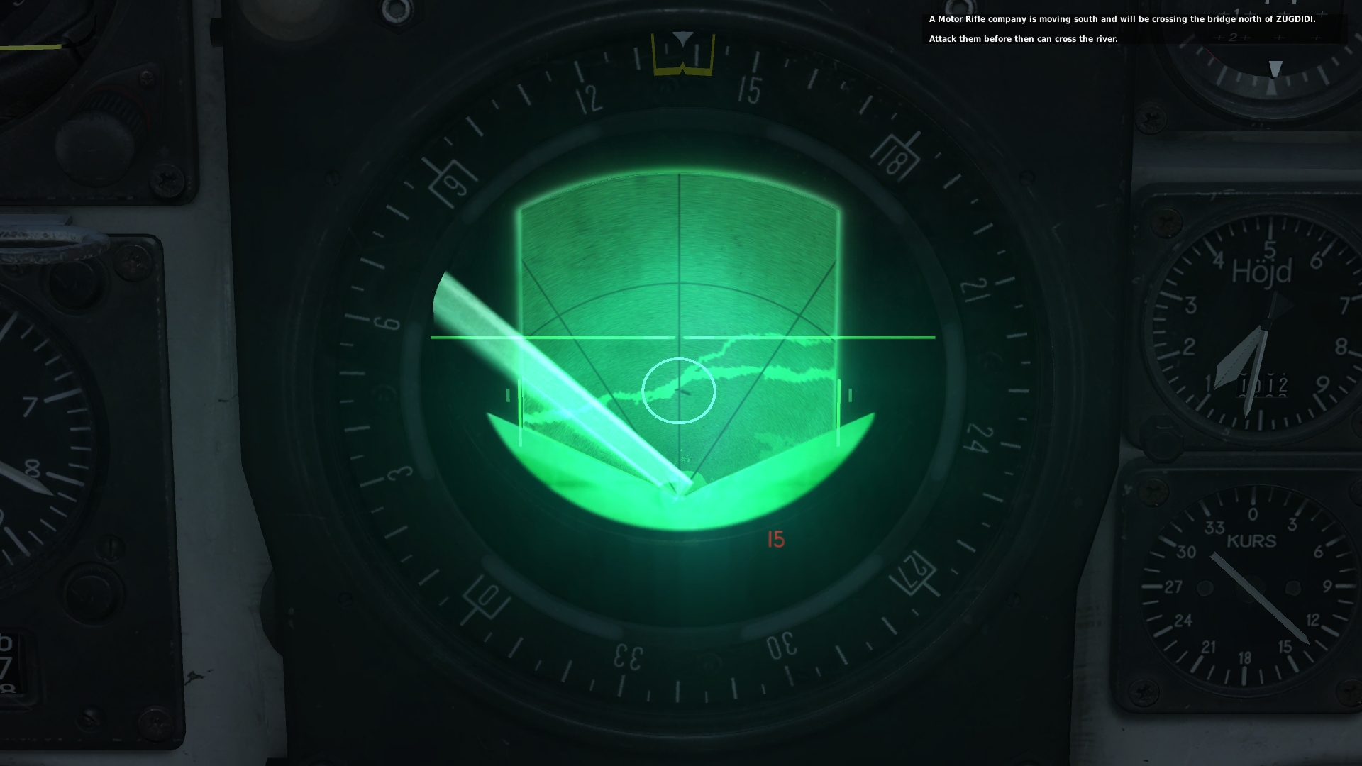
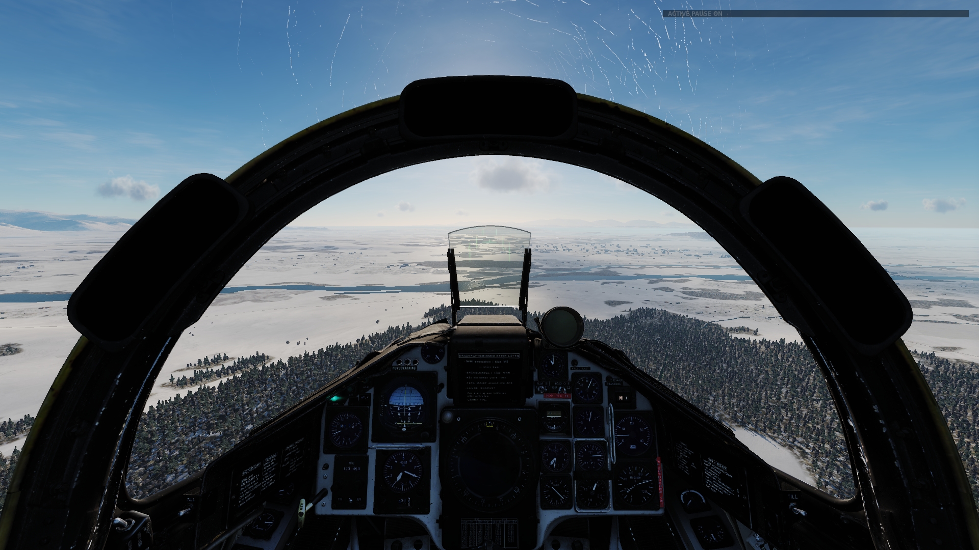
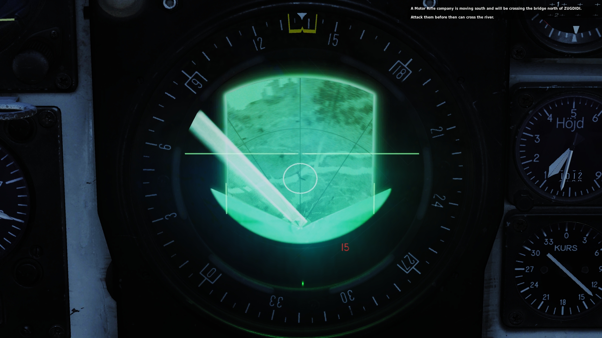
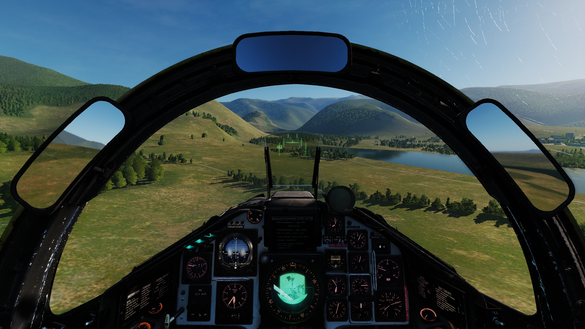
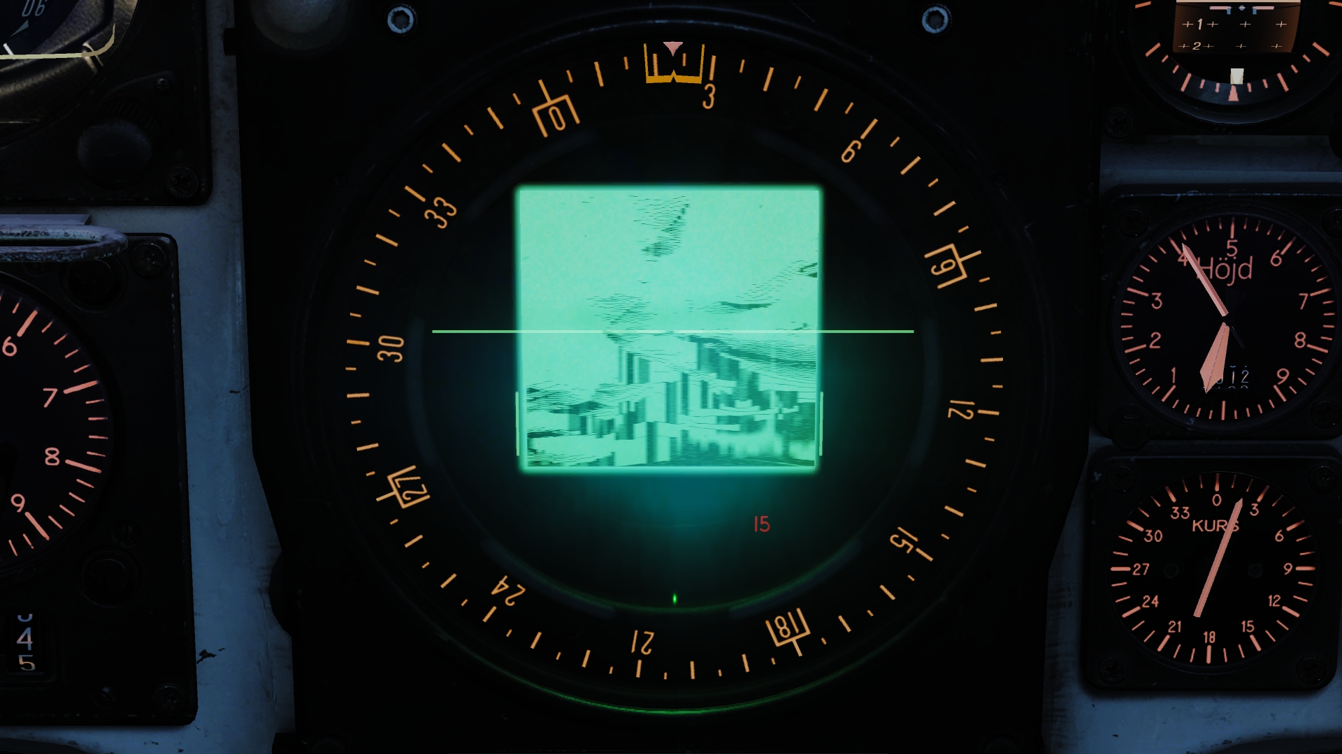
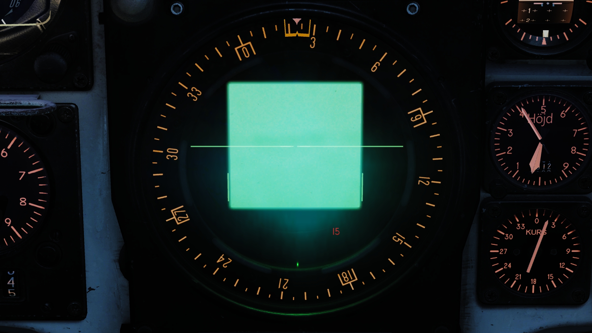
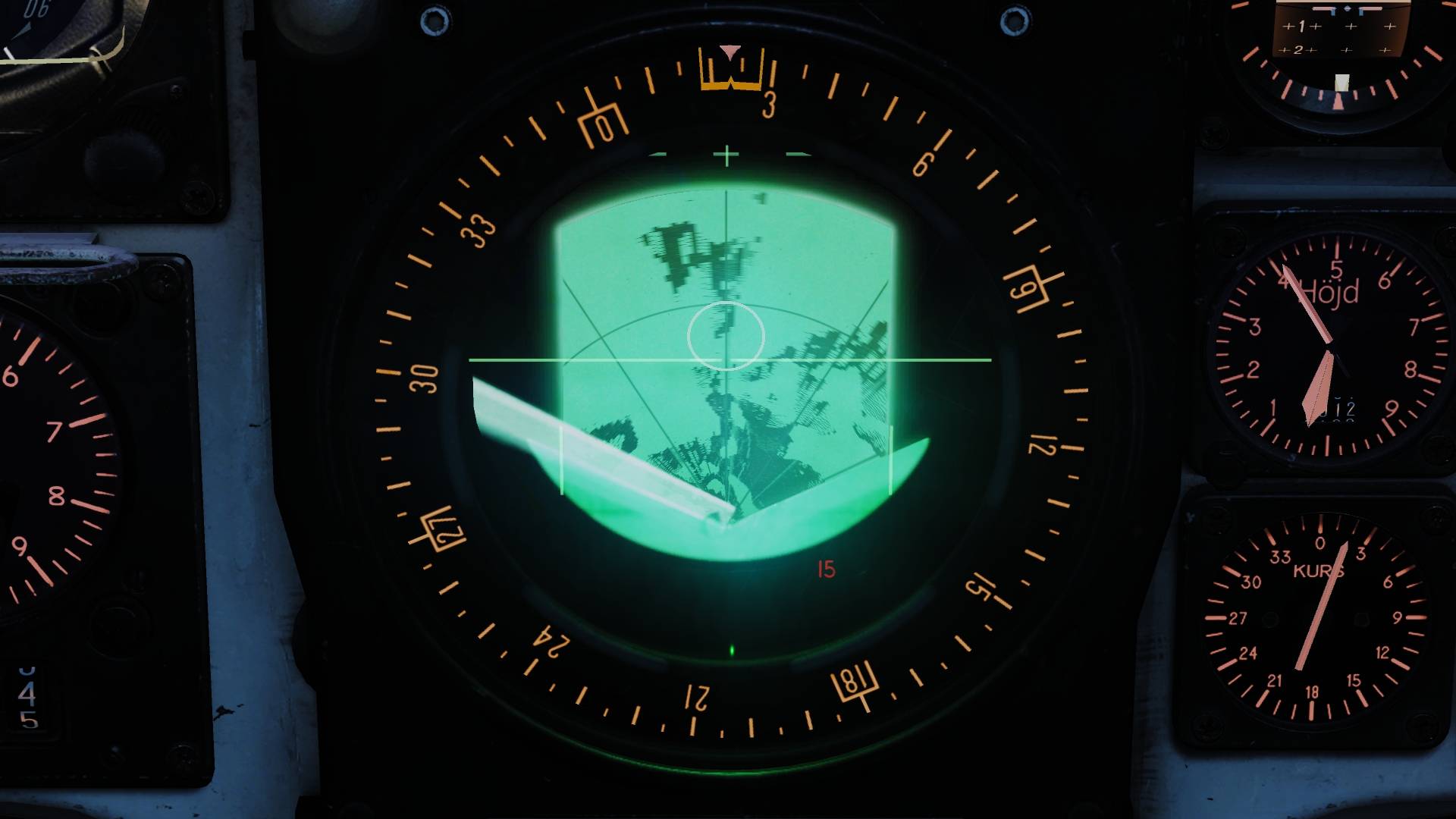
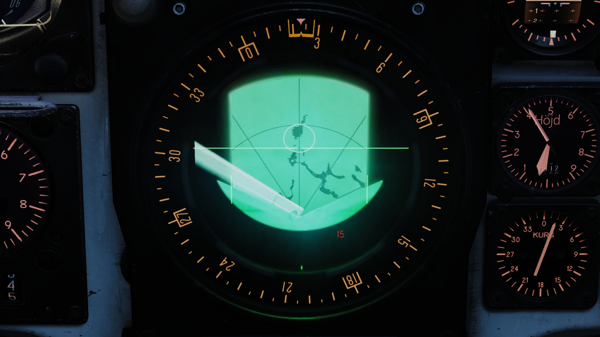
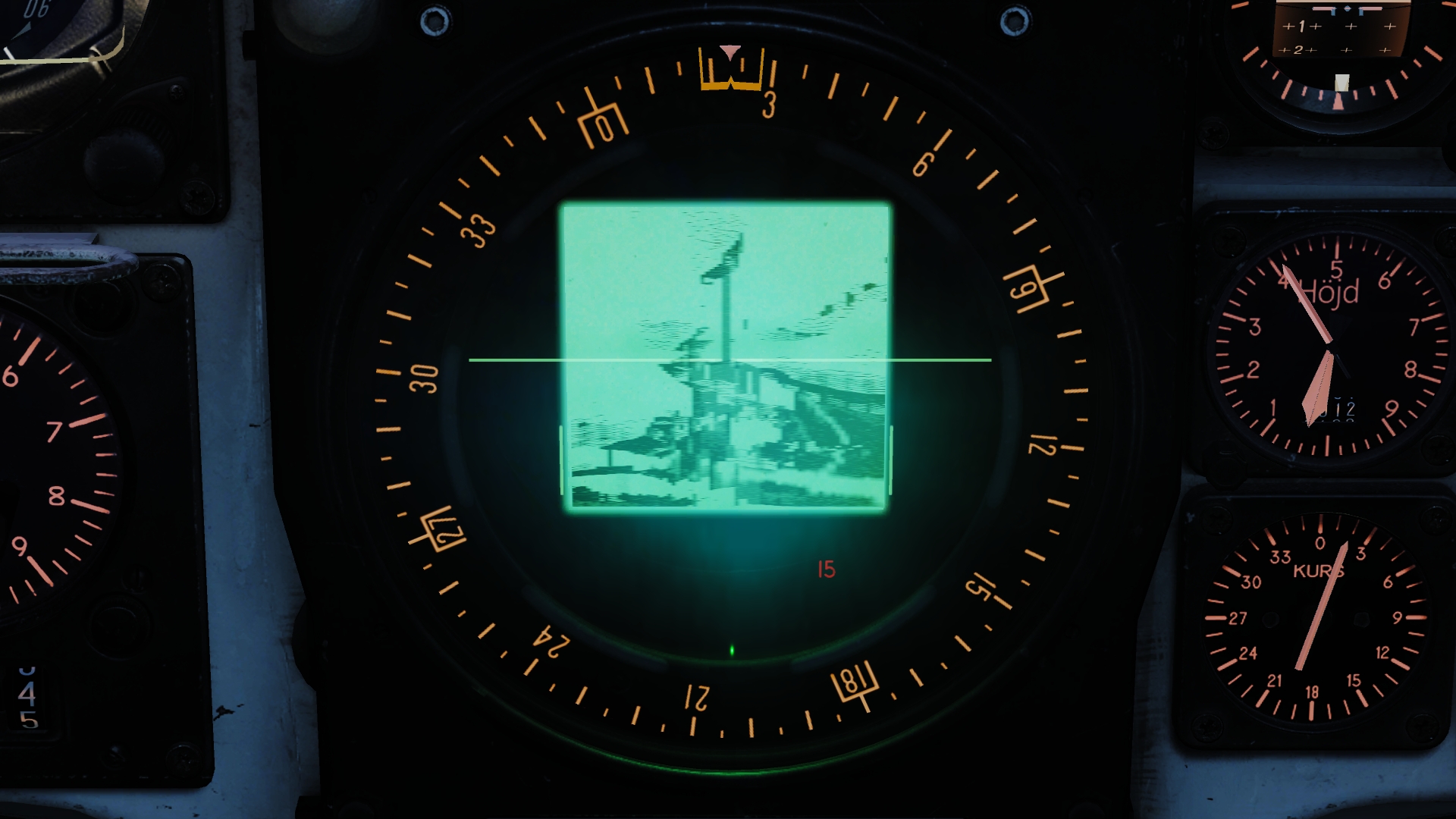
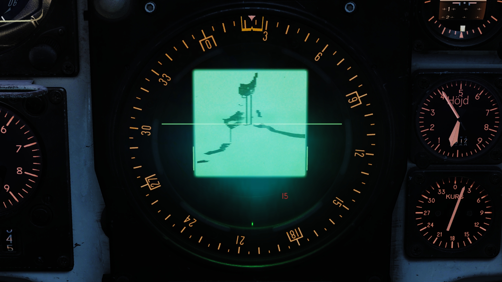
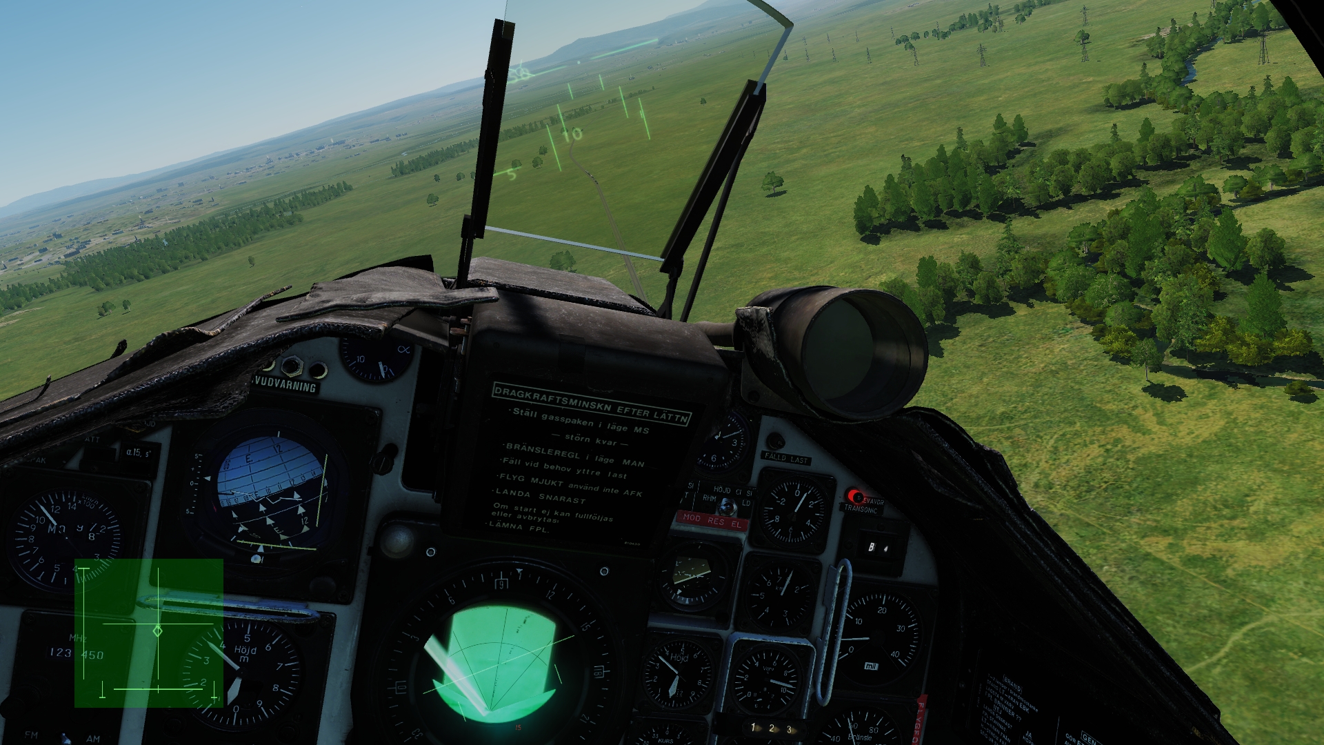
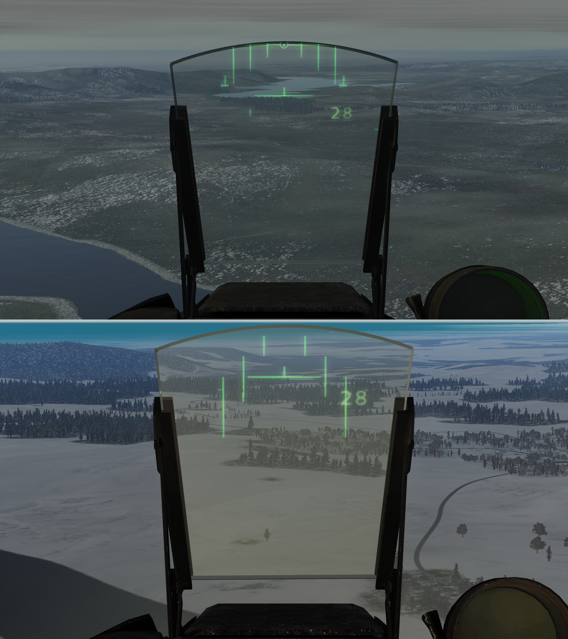
So, finally! At last I found out how to make the Terrain Avoidance Mode (TAM) actually show anything useful! It was due to a small bug and rather sensitive antenna elevation adjustments with only buttons (no axis exist for it what I know, pleas add) I could never make the TAM work as advertised in the manual. The manual states regarding the Antenna elevation potentiometer, p 115, and further on regarding TAM on p 117 it says I have always assumed "the middle position" imply the "middle “snap” position", and likewise the original position of the potentiometer at startup. But when the potentiometer is at that position, the radar in TAM show almost nothing regardless of terrain in front of you. I have earlier played around with the elevation slightly, but due to its sensitivity (and lack of axis control) it has been difficult to find that exact position giving you a good representation of the terrain straight forward. Even more difficult, not to say impossible, to actually trust it being really straight forward. When having AKAN one can see that elevation indicator above the radar screen. With the potentiometer in its original position the vertical indicator dash is not located in the middle as one could maybe expect, but on the right end of the middle horizontal dash. I have no clue if this is a correct representation in relation to the real thing. When adjusting the elevation, it appears to be a detent at that position though (with an axis control [highly desirable] that detent would not be desirable due to how game controllers are generally constructed and the lack of authentic potentiometers). So I put together a series of screen shots in AKAN mode, with the radar potentiometer in its original position and with the elevation marker at the middle of that horizontal dash (a little tricky to get it there, did I mention the lack of axis control?). I had the radar in LOG and in both PPI and B-scope, with and without TAM: Ocular View PPI original elevation PPI original elevation in TAM B-scope original elevation B-scope original elevation in TAM PPI adjusted elevation PPI adjusted elevation in TAM B-scope adjusted elevation B-scope adjusted elevation in TAM To me it looks like either (1) the antenna position when going to TAM at original potentiometer position is wrong, not 0° as stated, or (2) the original potentiometer position with associated detent isn't at all the middle position, as also stated, but the TAM elevation is related to it anyhow. Or the manual is wrong (3)? I vote for (2), without actually knowing. I attached the miz file used for the screen shots, starts with active pause at the exact location for my shooting session, for anyone who like to reproduce. EDIT: Yes, I'm on 2.5.3.24984 OB AJS37 Terrain Avoidance Mode.miz
-
If they are postponing the Mi-24 (I think I can use that word since they have worked on it for some time already what I understand), my hope and wish is that they postpone all new content equally, including third party modules, to release resources to iron out all those quirks we have with the base game, like deferred shading, AI behavior and the like, and with all those modules currently in eternal early release. It's starting to get tiresome and I think their reputation is starting to decline cause of it.
-
** UPDATE: Ground Radar 2.0 & Multiplayer Flight Planning **
Holton181 replied to Cobra847's topic in DCS: AJS37 Viggen
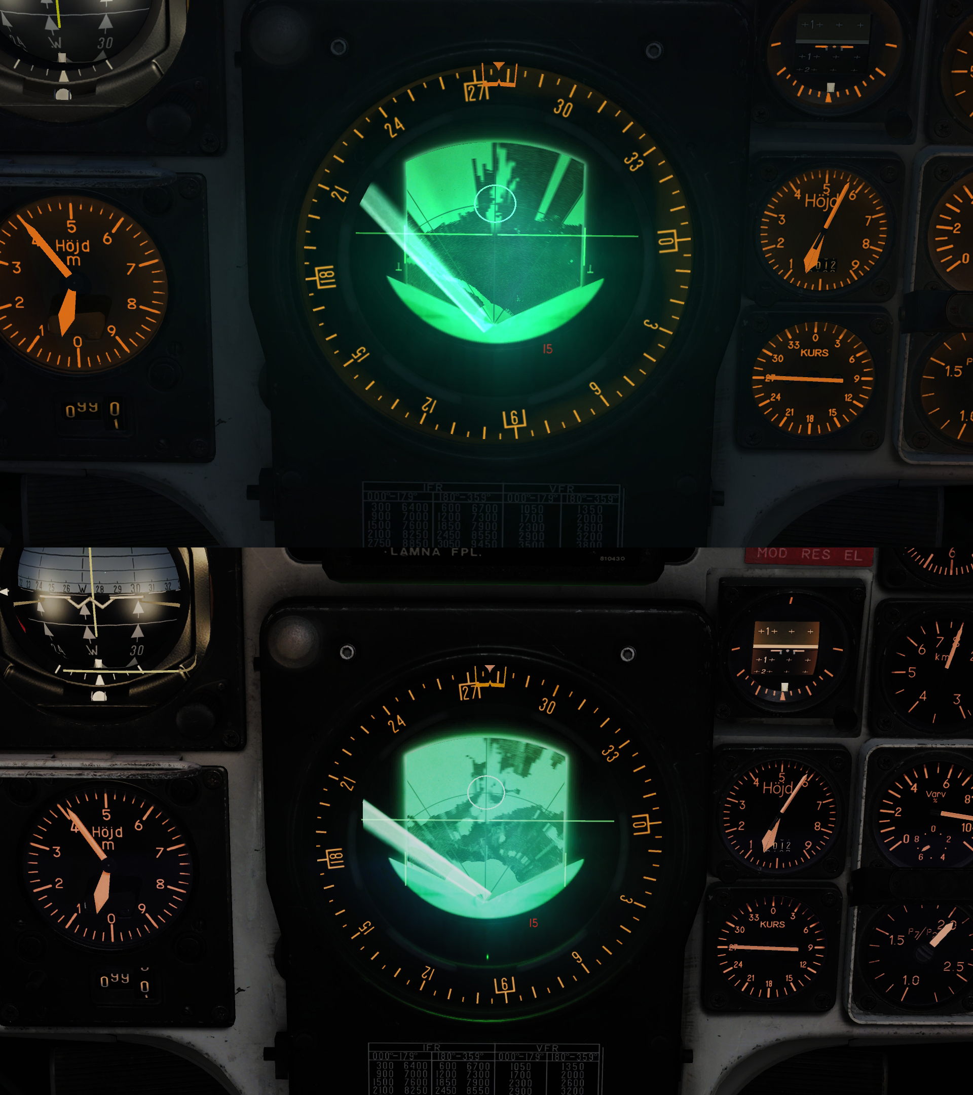
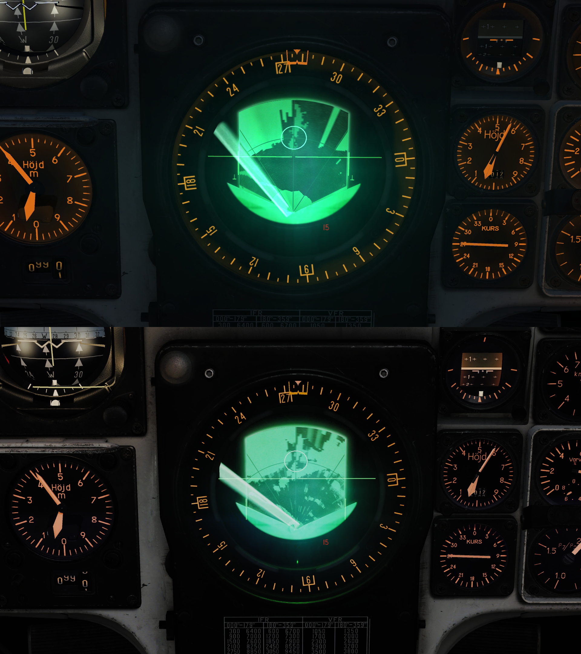
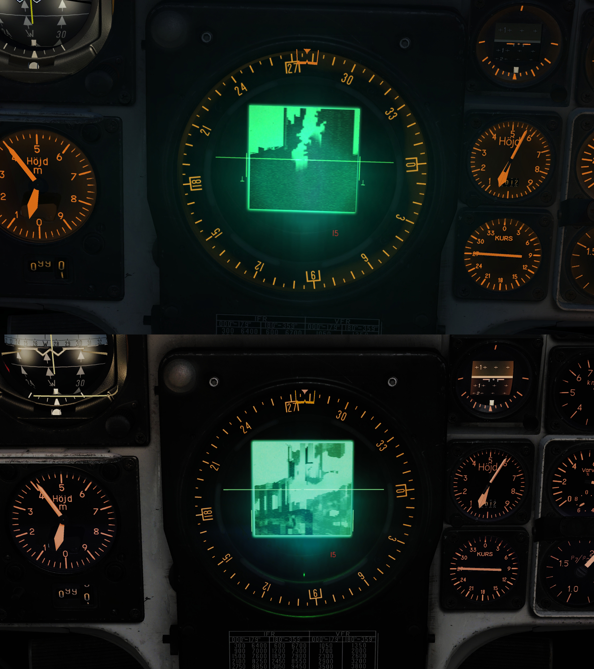
I put together some screenshots from the Interdiction approaching B3. I must admit I was a little bit harsh before, in LIN mode I actually got quite good results in 2.5.3, but it was more tricky to get than in 1.5.7. In LOG mode though it's useless in 2.5.3. Both these comments are valid for both PPI and B-scope. I used a slightly modified Interdiction from 1.5.7. I placed the Viggen in air at 400m AGL at a distance of 10km approaching B3 with active pause from start, so I could get the same view on the beak in the lake in both 1.5.7 and 2.5.3, and have time to tinker to get the best results. Copied the miz to 2.5.3 and re-saved the mission. So they should be almost identical. The elevation of the beak is 1m higher in 2.5.3 than in 1.5.7, and the ground below the aircraft 3m lower i.e. 4m difference, not much angle difference there. A little bit more trees in 2.5.3 that might affect the over all picture, but not the beak. Even if I could get a usable picture in LIN while in active pause, it's trickier than in 1.5.7. In 1.5.7 very little adjustments was necessary and the beak appeared clearly over a much wider range of the antenna elevation than in 2.5.3 (this goes for all four modes), much tougher doing the same adjustments while in M0.8, at less than four times lower altitude and hearing the RWR constantly beeping and flashing from all over the place. Each picture has the 1.5.3 screenshot above the 2.5.3 counterpart. Ocular view PPI LOG PPI LIN B-scope LOG B-scope LIN I wonder if low FPS or the snow (more snow in 2.5.3) can have an effect? In other missions with no snow (but marginally higher FPS) the difference between 1.5.7 and 2.5.3 is lower and LOG mode is usable, but still 1.5.7 is better. Regarding the trains showing up in terrain avoidance mode: From a distance Close What do you say? bug? With this said, the Ground Radar 2.0 is much, much better than in earlier 2.x, and I have no idea which version, 1.5.7 or Ground Radar 2.0, that has the most realistic picture. Over all a very good job done but with some room for further improvements.
-
Huey and landing! Where are those experts pilot with quick landing :)
Holton181 replied to Frag's topic in DCS: UH-1H
Thought that too. But the terrain looks open enough to make a wider approach (in the background so to say) and come in for landing into the wind. If that doesn't work and it is turbulence that make the pilot to opt for that approach, it is too much turbulence for heli-skiing in the first place (i.e. not worth the risks flying civilians for that cause, in those conditions). In my opinion he is also way to close the passengers for the actual landing. Would say it's all for the show. No doubt a skilled pilot (when it comes to control, not risk assessment...), but too bold. And I assume you all know the saying: “There are old pilots, and there are bold pilots, but there are no old, bold pilots.” -
Any way to remove auto switching waypoints?
Holton181 replied to DarkStar79's topic in DCS: AJS37 Viggen
I'm sorry, I don't mean to be rude, but I assume you mean "annoying" and not "enjoying"? With "enjoying" it gets a little bit contradicting to your question. Unfortunately I have no answer to your question though, I simply don't know. -
A Bunch of Questions and their Answers from the PolyChop Discord
Holton181 replied to Nightwolf's topic in SA-342M Gazelle
Yes, good questions, reasonable and understandable answers and a good and respectful sum-up. Thanks for bringing it to us not following discords. -
But I just read in the manual, it implies the passive mode can be turned on while in A0 (radar off). Maybe that is what OP means? That it doesn't tur off from that configuration? Not at home to test it myself at the moment.
-
** UPDATE: Ground Radar 2.0 & Multiplayer Flight Planning **
Holton181 replied to Cobra847's topic in DCS: AJS37 Viggen
Will do, but may not be able to today but will try. -
** UPDATE: Ground Radar 2.0 & Multiplayer Flight Planning **
Holton181 replied to Cobra847's topic in DCS: AJS37 Viggen
So, I have now tested Interdiction with the fxo and metashaders2 emptied (see my other post, #133 above). Unfortunately the radar still isn't showing a good enough picture over B3 to use that little beak in the lake as a nav fix. It is super clear in 1.5.7. Anyone else that can confirm? Is it due to the snow? low FPS? I have it in short puls, log and PPI, but equally bad in B-scope. Since I can easily make the beak visible in 1.5.7 I don't believe it's user error, but I'm open for suggestions. -
I am no expert, so I hope to be corrected if wrong. The passive span basically turns off the radar emitter, but keeps the receiver on to detect "incoming" radar signals. By turning off the emitter there is a reduced risk of being detected while still having an idea where other radars are located. Turning passive span off returns the radar to its full functionality. You should get the warnings in both modes. When you turn it off, does the radar work as intended?
-
** UPDATE: Ground Radar 2.0 & Multiplayer Flight Planning **
Holton181 replied to Cobra847's topic in DCS: AJS37 Viggen
Yes, seems to be improved. At first I could not really see a difference in my benchmark mission, Interdiction (B3 is a good indication, clear in DCS 1.5.7) and was disappointed. Then remembered I hadn't removed the old files in fxo and metashaders2. Don't know if it should help and I haven't run Interdiction afterwards yet, but in another shorter mission it did look improved. I actually saw some benefits reducing gain a bit too, never seen that before. But I'm disappointed with the terrain avoidance mode. It is still useless, still all empty (except one thing, se below) screen whatever I try. Or I simply can't handle it correctly. But I saw one difference from before, trains appear quite clear in this mode. Doesn't seem to be altitude or attitude dependent either. From my understanding (which might not be correct) this is not how it is supposed to be, with the radar elevation straight forward. If anyone can get any useful and for the mode relevant information in terrain avoidance mode, please share your routines, videos are welcome. Another question: I get the feeling the quality of the radar image is FPS dependent. Is that correct? I get quite low numbers in Interdiction, around 20 (2.5, not so low in 1.5.7). -
Complete Transport and Logistics Deployment - CTLD
Holton181 replied to Ciribob's topic in Scripting Tips, Tricks & Issues
Good to know. All scripting guides I've read mention to delete and re-add, but I very seldom use scripts and haven't read that many guides either though. -
Complete Transport and Logistics Deployment - CTLD
Holton181 replied to Ciribob's topic in Scripting Tips, Tricks & Issues
For what I know, all scripts added in a mission will be packaged in the miz file together with everything else related to said mission. You basically just copy whatever script file you use into the mission. That is why you always have to remove the "do file" (or whatever it's called) instance in the trigger and add it again whenever you make any changes to the script file. -
reported Cold Start Tutorial - APU shutoff lengthy sequence
Holton181 replied to Ralphk's topic in Bugs and Problems
So, ten month since the OP... I found the "problem". It's no problem, only impatience... Actually, after pressing the APU OFF button one needs to wait until the APU temperature has fallen to about 100 deg C. In the ME I saw that the argument used for going to the next step is 402 (APU_temperature, mainpanel_init.lua) with limits from 0.0 to 0.1, which translates to "below (roughly?) 100 deg C". So I started the mission and after pressing APU OFF I waited and monitored the temperature. And yes, after a long wait, at 100 deg C the mission continued. My suggestion to the developers, if at all noticing this thread, is to increase the upper limit for the argument or simply use the APU_pressure instead (falls quickly). I don't believe one have to wait for the temperature to fall that low IRL. It is actually also a flag timer of 5s before continue, so no risk of going to fast. Just be aware, at the radar altimeter step it says "...It will take a few seconds to respond and perform a function test". The "a few seconds" turns out to be more like "a lot of seconds". Just be patient... -
Tested the take-off procedure training mission, no shaking for me. On latest OB. Guess it would be a good idea for you to post a new thread about it, we are going quite off-topic here.
-
Short but nice one! And excellent voice-over, sharkku! Thank you both!