Stuka
-
Posts
1503 -
Joined
-
Last visited
-
Days Won
7
Content Type
Profiles
Forums
Events
Everything posted by Stuka
-
reported
-
Reported
-

ILS for Nellis not for runway 21?
Stuka replied to sleat's topic in DCS: Nevada Test and Training Range
Correct , the only RWY at Nellis with ILS is 21L, on 109.10 Not sure how the Hawk deals with beacons. -
Got a track? When I try to reproduce it, it works normal.
-
Thanks for the mention Rakuzard, On our site, we also have the complete R-2508 complex for download available for Tacview: http://www.476vfightergroup.com/downloads.php?do=file&id=450
-
ED SIMS SCREENSHOT AND VIDEO THREAD!!!! (NO USER MODS OR COMMENT)
Stuka replied to rekoal's topic in Screenshots and Videos
-
Eastman Airfield Target (Nevada, Range 76)
Stuka replied to Gierasimov's topic in DCS Core Wish List
https://forums.eagle.ru/showthread.php?t=154593 Target 7603 is what you’re looking for. -
NTTR info and mission by the 476
Stuka replied to Stuka's topic in DCS: Nevada Test and Training Range
I do believe indeed that No Name = Chalk mountain -
ED SIMS SCREENSHOT AND VIDEO THREAD!!!! (NO USER MODS OR COMMENT)
Stuka replied to rekoal's topic in Screenshots and Videos
-
NTTR info and mission by the 476
Stuka replied to Stuka's topic in DCS: Nevada Test and Training Range
Glad you figured it out TJ. On top of Google Earth, all points are also available in the "area points" section on our site. -
NTTR info and mission by the 476
Stuka replied to Stuka's topic in DCS: Nevada Test and Training Range
First post updated with lastest info. Latest version of the mission is available on our site. For information about each individual target, the NTTR Ranges and Targets pages are available on our website for those who have an account and are logged on. These pages don't only give you information about the ranges, targets and what they represent, but also the exact location in different formats, ROE's, intel pictures, and plenty more. This is part of our mission planning and training tools, and are continuous updated with additional information. -
NTTR info and mission by the 476
Stuka replied to Stuka's topic in DCS: Nevada Test and Training Range
Within the 476 we use the NTTR like they do in real life. All targets are “dumb” units forming the desired “enemy” formations. We use this to practice tactics, techniques and procedures. You will also notice that in the type of units being used. If you look on Google Earth, you will see that they use M113, trucks, jeeps, old US tanks and so on, to represent enemy tank formations for example. The Nevada dessert isn’t filled with T-80’s :) In our internal version, just as in real life, we have a network of (mobile) threat systems that we can enable as we see fit for a certain scenario or excercise. We also use the Moose missile training script. The combination of all that gives us endless possibilities in setups, to make every mission unique. If we want to do scoring of bomb/strafe runs, we use Tacview. That is setup on our server to make server side recordings for each client. -
NTTR info and mission by the 476
Stuka replied to Stuka's topic in DCS: Nevada Test and Training Range
In the next update, I will include some “light” versions. 1 where only the Northern (70’s) ranges are in, and another one with only the Southern (60’s) ranges. Depending on your plans you take one or the other, if your system doesn’t really like the full version. -
ED SIMS SCREENSHOT AND VIDEO THREAD!!!! (NO USER MODS OR COMMENT)
Stuka replied to rekoal's topic in Screenshots and Videos
-
ED SIMS SCREENSHOT AND VIDEO THREAD!!!! (NO USER MODS OR COMMENT)
Stuka replied to rekoal's topic in Screenshots and Videos
-
NTTR info and mission by the 476
Stuka replied to Stuka's topic in DCS: Nevada Test and Training Range
I’m working on something. Might be slightly better than the pdf list. :smilewink: -
NTTR info and mission by the 476
Stuka replied to Stuka's topic in DCS: Nevada Test and Training Range
You're welcome. Happy that the problem is solved. -
ED SIMS SCREENSHOT AND VIDEO THREAD!!!! (NO USER MODS OR COMMENT)
Stuka replied to rekoal's topic in Screenshots and Videos
-
NTTR info and mission by the 476
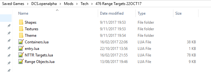
Stuka replied to Stuka's topic in DCS: Nevada Test and Training Range
Weird. Can you show me the content of the folder "476 Range Targets 22OCT17" ? Also, make absolutely sure there's no more 476 range target folder in your DCS install left under mods\tech. So the saved games location should be the only one where you have it.
-
NTTR info and mission by the 476
Stuka replied to Stuka's topic in DCS: Nevada Test and Training Range
I wasn't even aware there was a VR version of Google Earth :) -
NTTR info and mission by the 476
Stuka replied to Stuka's topic in DCS: Nevada Test and Training Range
The mod only installs the objects in DCS, there is no mission included (maybe an idea for the nex version). The link posted by mwd2 links to a mission that is a a representation of the real world NTTR ranges. That mission needs the mod to work. -
NTTR info and mission by the 476
Stuka replied to Stuka's topic in DCS: Nevada Test and Training Range
I'm not sure what you mean. Load the google earth link in the sim? -
NTTR info and mission by the 476
Stuka replied to Stuka's topic in DCS: Nevada Test and Training Range
Install the mod in the saved game folder, that will fix the problem. -
Any ETA on a fix for this ?
-
NTTR info and mission by the 476
Stuka replied to Stuka's topic in DCS: Nevada Test and Training Range
Hey Sacha Plenty of frequencies to be found here: http://www.dreamlandresort.com/info/scanner.html