Mikaa
-
Posts
105 -
Joined
-
Last visited
Content Type
Profiles
Forums
Events
Everything posted by Mikaa
-
When flying Acro at higher elevations with a standard altimeter, a lot of us will set a pseudo QFE + 1000, so ground level will indicate 1000’AGL. In RL you have to be extremely cautious, because if you’re not on your game, it can get you into trouble quick. It does, however, offer the ability for quick AGL references by subtracting 1000ft rather than doing harder math while upside-down in the box. Maybe try this for ground attacks by figuring out QFE for your target, and then add one “Hg to bring it within the capabilities of the Altimeter. There’s not much else you can do with the limitations of a steam gauge ALT.
-
+1
-
I wonder if the DCS/RL table differences relate to some of the Drag coefficient wonkiness that's been noticed in multiple modules.
-
An equip-able refueling probe ala the JF-17 would be great, and at bare minimum, a panel mounted NS430 so we can do some more direct routing in IMC rather than using TACAN and mental gymnastics.
-
[ALREADY REPORTED]Crosswind drift in a bomb run
Mikaa replied to TAW_Impalor's topic in Bugs and Problems
It’s because the ^ is not properly wind corrected in the HUD. Not your fault. -
I totally understand that coding is difficult, and often times weird bugs are buried deep, taking many hours to track down and even more to fix. However, it'd be nice to hear an update, even if it's just a "yep, we're still working on it!" Side note, I wonder if these issues are related to the KEAS/KCAS problems seemingly identified to be linked to many DCS aircraft. https://forums.eagle.ru/showthread.php?t=276363 There might be some larger base coding problems that need to be sorted or rewritten, and it might affect all a/c (KEAS/KCAS, GS and wind issues, engine performance, etc...).I'm just spitballing, but a lot of those variables are highly interrelated, and speculated to be influencing the flightmodels (confirmed for the F-5 engine modeling at the very least). With zero wind, a lot of these problems go away, but I have a sneaking suspicion that something unintended is going on that's permeating throughout the code. edit: spelling
-
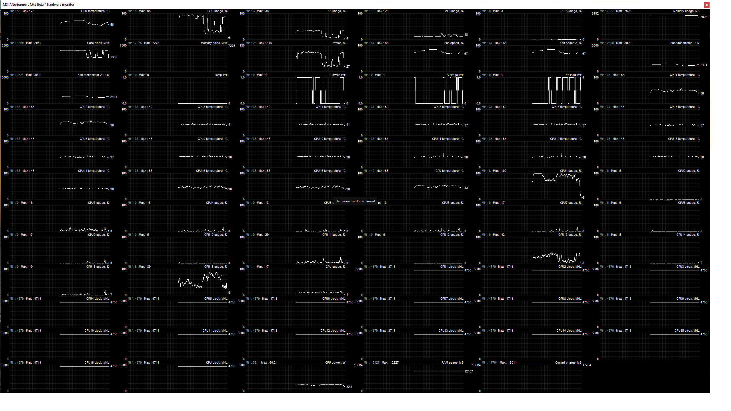
Not sure if this is already known, but as I was doing some testing, it appears that there's some weirdness with the GPU/CPU utilization when the radar is turned on. My GPU drops from 95%+ down to <30% utilization when the radar is flipped from STBY to ON. At the same time, core 16 on my CPU jumps up in utilization near 90-100%, and both appear to have some oscillations in % usage. I can even hear it as the GPU fan ramps down as the radar is turned on. Not sure exactly what this is indicating, but Hopefully this helps with troubleshooting, whether ED or 3rd party dev. Mig-21 Radar Bug.trk

-
Digital one if we can only get one version. At the end of the day, either will be killer!
-
No problem! I was just confused as to what you were asking for. I entirely agree that it'd be nice to have a more comprehensive set of tweakable parameters for Wx in the sim. Maybe this will come after they implement the revised cloud modeling.
-
Okay, I believe I understand what your question is. You're asking about implementation of minor atmospheric variations even under steady state wind conditions in the sim. Let's just be clear that this has absolutely no bearing on Air Data Computers, Pressure Transducers, indication of IAS, or calculation of CAS, EAS, TAS or GS, whether through ADC input/output or Steam Gauge ASI/E6B (whether it be in sim, or in real life). Additionally, this is already somewhat possible in sim. Add a small amount of turbulence in the mission editor (value of 10 or 15, which is multiplied by 0.1 feet) and you'll get small variations in alpha, and as a consequence, airspeed speed within the sim. Yes, it would be nice to also have a separate gust factor slider in addition to the steady state wind, but this is not a bug related to the F-18C, or any aircraft in DCS, but rather in relation to the atmospheric modeling and implementation of weather. I suggest you add a post to the DCS World 2.5 Wishlist for these additional parameters.
-
The best example I use with my students is to equate wind to a current in a river. Think about it like you’re swimming in a river at 5 knots (This is your CAS), and the river’s current is flowing at 2 knots. Attempt to swim upstream, and relative to the shore, you move more slowly (only 3 knots, which is our Groundspeed) but relative to the water, you’re still swimming through it at 5 knots (Our CAS still shows 5 knots). Turn around, and swim with the current, and you’re now moving at 7 knots relative to the shore (our Groundspeed is now higher). But relative to that stream of moving water, you’re still swimming at 5 knots through it (5 knots CAS, plus the 2 knots of current = total GS of 7 knots). Make sense? When you’re in the air, the aircraft flies relative to that moving mass. Assuming constant power and negligible drag influences from the turn, changing from headwind to tailwind will not affect any airspeed (IAS, CAS, EAS, or TAS). The only thing that will change is your Groundspeed. And I’m not talking about edge cases like wind shear etc., because those aren’t applicable here.
-
I did some playing around with intentional departures in it, and it seems that there’s very little rudder authority, to the point where I’m having a hard time getting it to spin. This could entirely be the case in the real aircraft, but I wonder if the rudder authority needs to be tweaked at higher alphas.
-
They did mention in one of the previous bug posts that fixes should be coming soon. It's just eerily quiet in this sub. Hope it hasn't been pushed to the wayside for the newer, shinier, a/c. I really miss flying the F-5, but can't bring myself to use it in this state.
-
Can't say I've noticed that, but it wouldn't surprise me if it was related to the engine/wind performance bugs.
-
From my understanding and experience, the rapid onset of stagnant hypoxia from +Gz is too high to be prevented by a pressure demand system. It stands to reason it may have some effect, but marginally effective at best (read negligible). If you G-LOC, once you’re out, you’re out. However, 100% PPO2 will help with recovery from hypoxia (whether hypoxic or stagnant), so there’s that.
-
That makes sense; didn’t see that older post. It’s a minor inconvenience compared to other missing features, and I’d rather they spend dev time on the larger issues/feature implementation first. They’ll probably have to come back to rework all this for the ATFLIR, if not before.
-
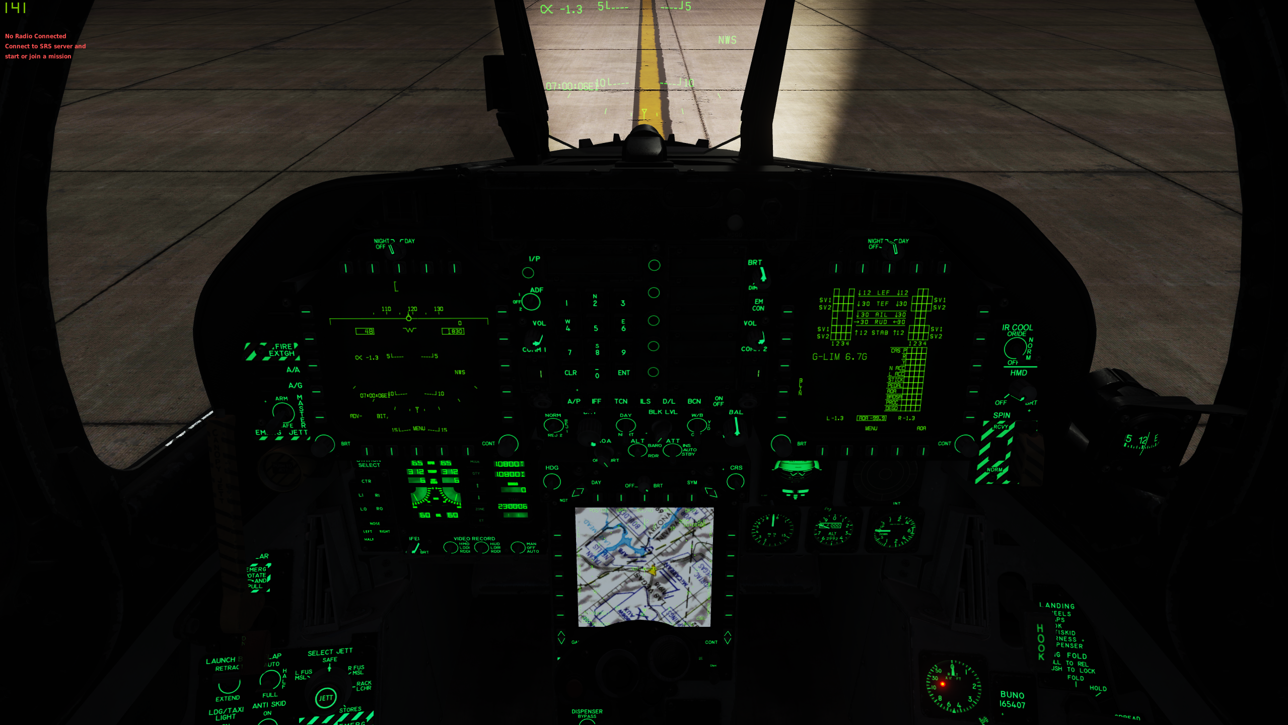
It seems like the brightness and transparency scaling of text, relative to the background MAP brightness is incorrect. Either the map is washed out, and text is clear (albeit a bit thick unless you zoom in), or the map is readable, and the text is too transparent, even with full SYM brightness. This becomes most apparent at night, where the NGT setting for the MPCD is useless, as the text transparency is too high even if you turn up the SYM. I've attached a screenshot to illustrate this. Just a bit of tweaking to decrease the transparency of the text, relative to the overall brightness, could go a long way to making this easily readable, both day and night.
-
fixed [REPORTED]F-5E incorrect engine behavior with strong winds
Mikaa replied to Vyrtuoz's topic in Bugs and Problems
Yea, I figured as much, but thought I'd ping here as sometimes backend stuff slips through the patchnotes. -
fixed [REPORTED]F-5E incorrect engine behavior with strong winds
Mikaa replied to Vyrtuoz's topic in Bugs and Problems
Just checked in the latest OB, and it appears to still be present. Anyone else confirm? -
Thanks for flagging this. Between the Grid discrepancies and inconsistent wind steering cues, I was getting thoroughly confused.
-
Update: I just checked the other maps to determine their Grid vs True North Errors. Perfectly acceptable at <1-2 degrees, sometimes as high as 3 on the edges of the map. That lies within the margin for error in piloting skill - absolutely no issues with this. And I totally understand from a development point of view that the Caucasus map is old, and free, but that really sucks that none of the basic nav functions work properly there for any mag instruments if wind is present, and the only way to navigate to anything on the ground dead reckoning style is without wind and via Grid HDGs. So using the PG map, which has a variation of 2 degrees, I set up a similar test, but this time, there is negligible difference between Grid and True, so we should get pretty accurate HUD Command Heading Steering for both Mag, and at the very least, True HDG mode right? Nope. There is absolutely no wind correction applied to either the F-18's HUD Command Cues, or the F-16 Tadpole in the PG map. Ironically, without an appreciable Grid vs True error in the PG map, the Hornet's HSI wind drift barb is actually correct here, in both Mag and True mode, just not the HUD. I then went to the Nevada Map, where the variation is 12.7 degrees. Similarly negligible Grid error (about a degree near most of the airports), and it's the exact same problem as PG. Zero wind correction is applied for both the Hornet and Viper. I then checked Normandy... same as PG and Nevada. So the default free map has a grid error relative to nav instruments, but correctly applied wind drift to the HUD cues... The actual paid DLC maps have a barely significant grid error, but no accounting for wind drift in the HUD... What is happening?? I'm going to just chalk all this up to Early Access, and assume it's being worked on, but I'd love someone who knows better to hop in and provide some insights, and whether this is going to be fixed. As it stands, effective nav using the HUD Cues is impossible.
-
I figured as much (see the bottom of my first post). So we're dealing with a conic/stereographic projection of some type. Oof. This means that every aircraft is affected, and as soon as any wind is applied, all navigation goes out the window because the supposed headings to fly don't account for the difference between True North and Grid North. Now for something simple like the F-5, although less than ideal, we can just apply an additional correction when flying off the compass (in the case of Eastern Caucasus, just subtract an additional 6 degrees from the wind corrected Mag HDG). Funny thing is, the way the aircraft are coded (I checked this in the F-5), it thinks that True North IS Grid North, because when I loaded the exact same mission and winds in the F-5, it pre-selected a HDG Bug of 167ish (which is the correct wind adjusted HDG to fly relative to Mag North). But like in the F-18, you won't get where you want to if you fly that because of the Grid displacement. Now the problem with advanced aircraft that rely on INS Position, and have very complex nav systems coded to great detail (i.e. F-18 and F-16), is the wind corrections are applied thinking that True North = Grid North... so it's completely useless to even look at the HUD cues. Although they seem correct, none of the numbers or guidance on the HSI or HUD corresponds to what you see outside the cockpit. I tested the exact same mission in the F-16, and sure enough, the Tadpole does the same thing - Shows the correct wind adjusted track to fly, relative to True North, so we're off course by exactly the delta from True to Grid.
-
Apologies if this is already reported or known by devs, but I searched for keywords couldn't find anything specific to this (although I suspect many other wind related issues for autopilot HDG etc. stem directly from this one). I believe I've found the source of all of these nav problems with with Command Steering Cue and the HUD/HSI applying the Magnetic Variation Twice. This was really annoying me, so I took the time today to figure out what's going on. A few Assumptions before we begin: -Auto Throttle and BALT are used to ensure the only flying variable is HDG control - FA-18C onboard variation of ~6.45-6.5 degrees is correct (6 degrees 27', or 6 degrees 31' on HSI A/C Data Page) - The Waypoints set up for the test equate to 180 Degrees True - Assuming the mission editor Lat/Long are correct, WP0 is (N43,00',00"/E41,45',00"), and WP1 is (N42,15',00"/E41,45',00"), thus it should be 180 Degrees True Track. - Oil Rigs are placed along this track at various latitudes to give visual representation to ideal track - Wind in Mission Editor was set to "To" 264 Degrees Mag, which is "From" 084 Degrees M, or ~090 Degrees True, at 50 kts - Perpendicular to our flightpath - TAS of 496 kts is used at 22,000' (350kts CAS) to ensure uniform wind correction throughout - The above was calculated using standard ISA 29.92"Hg, 15 Degrees C, and an assumed density ratio of .498 at 22,000', equating to CAS 350, TAS 496, and GS 496-497, negligible increase, so TAS is assumed equal to GS. From the above, I independently calculated the various Courses and Headings required via E6B (MB-4A) to test the ingame command steering: TC=180 TH=174 MC=~173.5-174 MH=~167.5-168 Okay, with all that out of the way, here we go... Track 1 - Mag Error: This track shows that assuming the variation, and a WCA of -6 degrees East, the CORRECT Command Steering Cue for a heading of 167.5-168 Mag. HOWEVER, if this is flown via the Command Heading Steering Pointer lined up with the HDG Caret (as is prescribed in NFM-000 24.2.9.1), both the HSI, and HUD do not correspond to the required track, and we end up drifting. Looking at the HSI, we can see the drift error shows us flying approx 174 degrees. We'll come back to why this is... Track 2 - True Error: I actually flew this track first, but figured it would be better ordered like this in the report. Same setup as before, and the same correct Command Heading Steering Pointer of 167.5-168 is shown for correct Mag HDG. In the Data, A/C page, I then select True Heading. Again, the correct TH of 174 degrees is shown is displayed... but, I then fly the previous Mag HDG of 167.5 degrees, and you can see the correct track is followed all the way to WP1... Whats happening??? I believe the magnetic variation is being applied twice. Once, to the Command Heading Steering Pointer, and then the entire Heading tape and HSI is rotated an additional magnitude of the variation, so in Mag HDG Mode we're off by 13 degrees, and in True HDG Mode, we're off by 6.5 degrees. Track 3 - No Wind: Third track is identical to the first two, except now the wind is eliminated, meaning a MC and MH are identical, and TC and TH should also match. Variation is the only, well, variable. It initially is commanding ~167.5-168 Magnetic to WP1, which is NOT correct, but coincidentally, exactly double our variation. Switching to True Heading mode, the Tape shifts, and now we're commanded approx. 6-6.5 degrees from our known TC/TH of 180. You can see the oil rigs are perfectly lined up along this track, and in "True Mode" flying this Commanded "variation" gives us a proper track across the ground to WP1 (which it totally shouldn't). In Summary: It seems that Mag HDG mode has both the HSI and HUD tapes applying Mag Variation Twice - Once properly for the Command Cue, and then again, shifting the entire tape clockwise, doubling the effect. When wind is applied, the HUD steering cue is correct in relation to the heading tape it sits on, but the entire tape should be shifted counterclockwise the same magnitude of the variation in order for the Command Cue and HUD Caret (and im also thinking velocity vector) to line up properly for Navigation. When there's no wind, the HUD tape and HSI just needs to be rotated (again by the magnitude of the variation, or ~6.5 degrees CCW) so that MC=MH and TC=TH. A few closing notes: As I was writing this up, I noticed that Map North seems to be in relation to Magnetic, because the variation between the mission editor plotted track of 180T, and Map South are different by ~6 degrees East. Im betting that this is part of the culprit that's applying the variation a second time to the HUD HDG Tape and HSI. I also used the Caucasus map because the variation is ~6 degrees, vs (I think) 2-3 in PG, so any issues would be much easier to spot. I may test the other maps when I get the chance. I'd love some feedback from you guys. FA-18C Command Steering Mag HDG Error.trk FA-18C Command Steering True HDG Error.trk FA-18C Command Steering Error No Wind.trk
-
You’re probably thinking of United 232, where all 3 hydraulic lines in the tail were severed, and they used differential power alone to command the aircraft. Very quick thinking by the crew, saved a lot of people’s lives. Edit - just saw the Haynes comment, incredible actions by all of them.
-
[REPORTED]parked F18s cutting frames by half in VR
Mikaa replied to FoxDelta's topic in Game Performance Bugs
I'm not sure if something has changed since the most recent open beta update, but FPS appears to be lower in missions where the static high detail F-18C is present. It's always had a bit of a hit, but it seems to have a larger impact now. edit: I'm also discussing just in general, as I don't play in VR... yet. If something has changed, I'm sure it'll affect everyone across the board.