Search the Community
Showing results for 'MGRS'.
-
guys, if i press icp 4 stpt page, then SEQ, it should display mgrs after 3 sec but nothing happens. conversely if i select on icp, list 1 dest, enter mgrs and convert it function ok and then i have stpt in lat/long on stpt page any clue? thanks
-
Been flying Gamblers campaign again this weekend, and experiencing problems in setting up MGRS waypoints on 21-25 from JTAC. I can set up the MGRS waypoint, but when I look at where the waypoint dot for the coordinate appears on the HSD it is around 25 NM off. Cross-checking using the mouse pointer, coordinates and the F10 map it appears like the MGRS converts in the F16 to the incorrect Lat/Long coordinates. If I convert the MGRS myself to Lat/Long, and enter it manually as Lat/Long into ICP, it shows up in the correct place. I tried this multiple times in mission 13 of Gamblers campaign and every time the same thing happens. I don't see any bug reports about this - am I doing something wrong? Thanks
-
Hi Baltic Please for the sake of VR users keep the coordinates somewhere on the screen. We cant scribble them anywhere and it is very annoying to jump back and forth in message history. I have an exact ICP replica but still I'm not able to enter the data online with the text because MGRS is much more tricky. Thanks a lot!
-
Title says it already Is there a way to create a waypoint in MGRS and not Lat/Long since all the information given by wingman/jtac or whomever is in MGRS (at least I think so)? All I found is that I could convert a existing one in a MGRS in "read only"
-
It seems that MGRS coordinates are not currently working? The last five digits always result with 00000, even after entering the required 10 digits.
-

reported MGRS 1km grid square on Caucasus map have disappeared
stdsk posted a topic in Bugs and Problems
MGRS 1km grid square on Caucasus map have disappeared in the latest update. Is there a reason for this? -
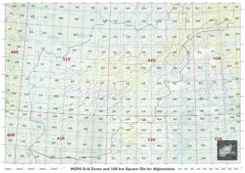
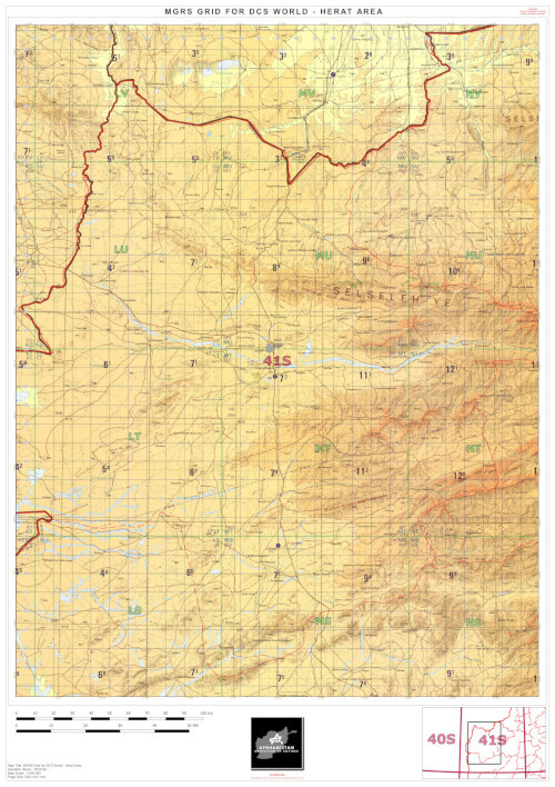
MGRS Coverage for Afghanistan and Overview Map Forenote: do you understand the differences between the various Military Coordinate Reference Systems (MGRS, CGRS, GARS, and more...)? If not, jump here :) For those interested, here are the Grid Zones for MGRS coordinates on the Afghan theater. Those who'd like to navigate more in details the MGRS grid for Afghanistan can visit https://mappingsupport.com. You can also download a high resolution 1:1.000.000 map here. Eventually, I also published 1:500.000 maps (more areas to come soon). Now you can enjoy hassle-free re-taskings anytime and anywhere!

-
ok, sounds fine to me but i read this at pag 109 in the manual, i tried and found does not work pushing SEQ..... If the steerpoint already contains Lat/Long coordinates, the STPT page can be toggled to display the equivalent MGRS location by pressing the DCS (“Dobber” switch) to the SEQ position. After a 3-second delay, the MGRS coordinates will be shown. The DED will display the MGRS Grid, Square, and Easting/Northing values, as well as the steerpoint elevation. If a steerpoint is to be entered using MGRS, the STPT page must first be toggled to MGRS format using the DCS SEQ position, the MGRS coordinates entered, and then a conversion must be manually commanded by selecting the CNVRT data field and pressing ENTR. If CNVRT is not commanded before the STPT page is toggled back to Lat/Long format, the conversion will not occur, the MGRS coordinates that were entered will not be stored for that steerpoint, and the Lat/Long coordinates will not correctly correspond with the MGRS location. The Time-Over-Steerpoint (TOS) and elevation (ELEV) data fields are not required to contain valid data for the conversion to occur. However, elevation can be entered on either format of the STPT page. The following page illustrates the entire process for entering a location via MGRS into steerpoints 21-25. STPT Page Lat/Long format (Left) and MGRS format (Right) (
-
MGRS coordinates can only be used on steerpoints 21 through 25.
-
This has been reported before but I’m not sure if there has been a solution. When acting as a player JTAC and passing MGRS grids through the binos, they are consistently 300-600 meters off the actual target. This was confirmed with multiple aircraft and multiple targets. When using LST to identify the targets, it worked correctly, with the laser being right on the target. Additionally, I was only able to test one target using last/long instead of MGRS, and it appeared to be more accurate, but I cannot say for certain. From my POV as the JTAC, it seemed like the grids were getting picked up beyond the target, as if the ranging laser was passing through the target. I will do some more testing when I have time.
-
 Theres an SA-5 site just east of Apolda, FRAG-511, but IRL this was never operational. MGRS 32 U PB 84163 57991.
 -

Kiowa needs map grids for Germany added
TokenJester replied to MatzWarhog's topic in DCS: OH-58 Kiowa
Cool, I flew some more in the Fulda gap with similar success, waypoints also worked for me around Berlin and up around Peenemunde, though I didn't input MGRS there.. I'll test later too. TJ -
I am not sure if to be adressed to ED or the Map producer but having legslly available 1:100k maps in the nav displays, especially for helos, navigation and combat organisation would be great. we usr MGRA grids but have no MGRS maps in the cockpit
-
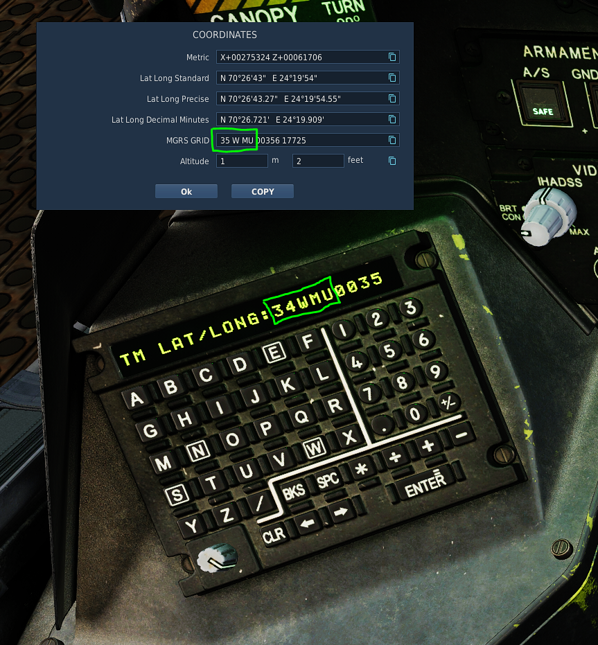
 It looks like when you edited the MGRS coordinates of your current position that come up in the KDU and changed them to the new coordinates, you didn't change the Grid Zone from 34W to 35W, and there is no MU within the 34W Grid Zone.
-
Placename typo - Update Girishk to Gereshk
Nealius replied to Nix Mills's topic in Bugs and Problems
Unlike a lot of languages that have one or two standardized romanizations, languages in this region don't. I've seen 4-5 different spellings for the same place across the ALT map, the MAP map, real-world MGRS maps, and Wikipedia. Getting all these names to conform to a standard is impossible when said standard doesn't even exist. -
The F10 map does not remember icon settings (e.g. Show MGRS grid). I turn off MGRS when I call up the map, and the next time I go back in game on the MP server, MGRS is back on again. Previously, the F10 map remembered the user settings. It hasn't worked for about half a year now.
-
- 1
-

-
Check the DCS F-16C Early Access manual (pages 200, 208-211) or Chuck's Guide (p. 701-702). Not sure what manual are you using, but check ED's and Chuck's and the MGRS thing is clear: It's available on steerpoints 21-25.
-
... и доделать то что в этой фотке обрезано снизу, а именно Гармин. То есть нашу его версию в виде NS430, чтобы MGRS принимала
-
The altitude data for this helipad is incorrect: Metric: X-00010726 Z+00008034 Lat Long Standard: N 34°55'39" E 35°59'31" Lat Long Precise: N 34°55'39.15" E 35°59'31.32" Lat Long Decimal Minutes: N 34°55.652' E 35°59.522' MGRS GRID: 36 S YD 73311 69096 Altitude: 334 m / 1097 feet
-
Ok problem seems to be related to something in the Gamblers campaign as I tried MGRS with a JTAC in a small mission and it worked. I will report the issue in the Gambler campaign bug section of the forum. Thanks for all the helpful suggestions.
-
Hello ! As a feature, to have a layer with DCS map (like in Olympus, or WebViewer) would be nice. The ability to display the map even with no data export from DCS (some servers do not allow this). In order to have a map. Usefull for nav with instrument or helicopter nav. A layer with MGRS grid displayed. Maybe the ability to add manual WP to trace a route directly on the map. Getting bearing (Mag and True) and distance in Km or nm. Thanks !
-

DML - Mission Creation Toolbox [no Lua required]
DD_fruitbat replied to cfrag's topic in Scripting Tips, Tricks & Issues
Yes, coordinates of the target Regarding the format, possibly lat long decimal might be best, as kiowa and Apache can use that to, along with jets which often can't use MGRS, but MGRS is fine if easier. It's easy to convert lat long decimal into lat long precise or standard, MGRS into those formats without your aircraft doing it, not so much! Thanks for looking into it, much appreciated -
scommander2, did you replace your movingmap-hook.lua in the DCS SavedGames Script folder with the newest version? I've fixed this error with the latest release. It should cause no problems though using the old version, apart from this dcs.log entry. --------- By the way, I am shortly releasing the next MovingMap version which will feature many user requests, included: - Map Zoom via keypresses (Windows version, allocable) - Map Zoom via Mousewheel (Windows version) - MGRS Coordinates - MovingMap will not close with ESC button Any other feature requests for the next release, please post them now!
-
(steerpoints 1-25) > steerpoints 1-20 (auto) > steerpoints 21-25 (only man) can also be displayed in MGRS format Active Navigation Route (white line) steerpoints 1-25. >>> The Bullseye point is normally set to Steerpoint 25, but can be set to a different steerpoint on the BULL DED page. > Steerpoints 26-30 are reserved as markpoints Each subsequent markpoint that is stored will overwrite steerpoints 26-30 in a cyclic fashion.
-

Can I input MGRS into the F16?
baltic_dragon replied to Viking 1-1's topic in DCS: F-16C The Gamblers Campaign
Yep! They almost exclusively used MGRS during their time in Syria, especially that with three different types of LAT/LONG input it created a lot of trouble.