buur
-
Posts
593 -
Joined
-
Last visited
Content Type
Profiles
Forums
Events
Everything posted by buur
-
Ok, had a short look into the mission. - Axemann mark the target by Laser and Willy Pete. But it seems that the distance fore Willy Pete is to long. Switching to only Laser and it works for me. - Placed the Hornet on ground (for easier testing) and I can talk to the JTAC without any problems. Please check your radio comms. I remember that for the hornet the comms will be slightly special. (try RALT+# or RCtrl+# when you are in air) Ok, tried it also in air and it is working.
-
1. This is normal, its about variety in the calls. 3. Unfortunately JTAC is not as stable as we wish. Need a closer look into mission to see what could be wrong 4. ED had to add the missing sound file for the AV8B 5. The AGM-65-E-2 is missing in the list of weapons the JTAC can request. Unfortunately the AI JTAC is not a well kept module in DCS and ED should do much more love for it.
-
here an second approach. This version do not need Mist, but is not able to show custom IPs on map. -- Refpoints2Map_v2 by buur function getTableSize(t) local count = 0 for _, __ in pairs(t) do count = count + 1 end return count end for i = 0, 2, 1 do --trigger.action.outText(i, 100, false) Ref2Map = coalition.getRefPoints(i) --trigger.action.outText(mist.utils.tableShow(Ref2Map), 100, false) if Ref2Map then for key, val in pairs(Ref2Map) do --trigger.action.outText(mist.utils.tableShow(Ref2Map), 100, false) local id_table = world.getMarkPanels( ) local size_id_table = getTableSize(id_table) local myCallsigns = { [0] = "N/A", [1] = "FORD", [2] = "EDSEL", [3] = "DODGE", [4] = "MAZDA", [5] = "BANKS", [6] = "CHEVY", [7] = "TOWEL", [8] = "ADDER"} trigger.action.textToAll( i, size_id_table + key, val["point"], {0,0,0, 1}, {0.8,0.8,0.8,0.5}, 11, true, "◊ "..myCallsigns[val["callsign"]] ) end end end
-
DP 217 607
-
 What I don't understand is the difference between normal and late activated. Also late activated units have their frequencies defined in the mission file. I need really a closer look how these databases are generated.
 -
I'm working in a script with mist.getGroupData() to get the frequency of an unit, working well. When I use a late activated unit in the output of mist.getGroupData() the value frequency is missing. And also a lot of other values. Is there a reason for this behavior? Is there an other way to get the value for the frequency from late activated units?
-
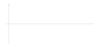
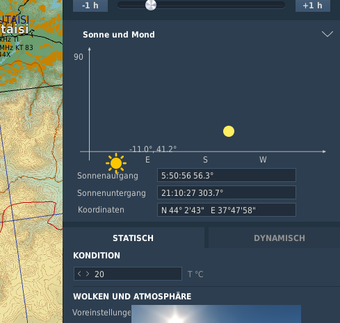
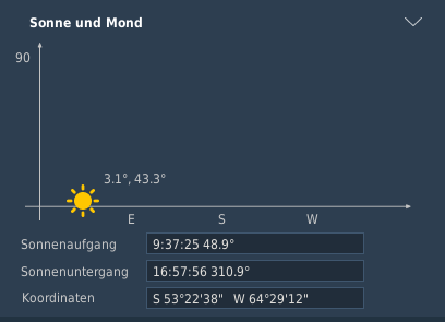
Just for documentation: Here the steps to modify the sun and moon chart. 1. Change the picture of the chart by coping the attached coordinate_axes.png to D:\SteamLibrary\steamapps\common\DCSWorld\dxgui\skins\skinME\images\window\weather 2. Override me_weather_panel.dlg in D:\SteamLibrary\steamapps\common\DCSWorld\MissionEditor\modules\dialogs In this file in the lines 7828, 7934 and 8108 the position of the cardinals E,S and W are changed. 3. Override me_weather.lua in D:\SteamLibrary\steamapps\common\DCSWorld\MissionEditor\modules the function updateSunMoon starts from line 1443. There you can change the position and when sun and moon are shown. function updateSunMoon() local player = mod_mission.getPlayerUnit() local x,y if player then x,y = player.x, player.y else x,y = centerWeather.x, centerWeather.y end local lat, long = MapWindow.convertMetersToLatLon(x,y) local coordDisplay = OptionsData.getMiscellaneous('Coordinate_Display') local SummerTimeDelta = Terrain.GetTerrainConfig('SummerTimeDelta') if coordDisplay == "Lat Long" then eCoords:setText(U.text_coords_LatLong('lat', U.toRadians(lat)).." "..U.text_coords_LatLong('long', U.toRadians(long))) elseif coordDisplay == "Lat Long Decimal" then eCoords:setText(U.text_coords_LatLongD('lat', U.toRadians(lat)).." "..U.text_coords_LatLongD('long', U.toRadians(long))) elseif coordDisplay == "Precise Lat Long" then eCoords:setText(U.text_coords_LatLongHornet('lat', U.toRadians(lat)).." "..U.text_coords_LatLongHornet('long', U.toRadians(long))) elseif coordDisplay == "Metric" then eCoords:setText(U.text_coords_Metric(x,y)) else eCoords:setText(Terrain.GetMGRScoordinates(x,y)) end local lastELEV = nil local sunRiseSec = nil local sunSetSec = nil for i=0, 23 do local degAZ, degELEV = DCS.getSunAzimuthElevation(lat, long, mod_mission.mission.date.Year, mod_mission.mission.date.Month, mod_mission.mission.date.Day, (i-SummerTimeDelta) *3600) if lastELEV ~= nil and lastELEV < 0 and degELEV > 0 then sunRiseSec = (i - degELEV/(degELEV - lastELEV))*3600 end if lastELEV ~= nil and lastELEV > 0 and degELEV < 0 then sunSetSec = (i + degELEV/(lastELEV - degELEV))*3600 end lastELEV = degELEV end --позиция солнца local degAZ,degELEV = DCS.getSunAzimuthElevation(lat, long, mod_mission.mission.date.Year, mod_mission.mission.date.Month, mod_mission.mission.date.Day, base.module_mission.mission.start_time - (SummerTimeDelta * 3600)) local timeIndex = 18 local x,y = chart:getPosition() local xSun = x-16+degAZ/360*332 local ySun = y-16+(73-((degELEV*2)/180)*73) -- -16 140 -- base.print("--x,y--", xSun,ySun,degAZ,degELEV ) if degELEV > -90 then -- 0 sSun:setPosition(xSun, ySun) sText:setText(base.string.format("%.1f°, %.1f°", degELEV, degAZ)) sSun:setVisible(true) sText:setVisible(true) if xSun < 315 then sText:setPosition(xSun+35, ySun-15) else sText:setPosition(xSun-110, ySun-15) end else sSun:setVisible(false) --false sText:setVisible(false) --false end local sunRiseAZ, t2 = DCS.getSunAzimuthElevation(lat, long, mod_mission.mission.date.Year, mod_mission.mission.date.Month, mod_mission.mission.date.Day, sunRiseSec - (SummerTimeDelta *3600)) local sunSetAZ, t4 = DCS.getSunAzimuthElevation(lat, long, mod_mission.mission.date.Year, mod_mission.mission.date.Month, mod_mission.mission.date.Day, sunSetSec - (SummerTimeDelta *3600)) eSunrise:setText(U.secToString(sunRiseSec)..base.string.format(" %.1f°",sunRiseAZ)) eSunset:setText(U.secToString(sunSetSec)..base.string.format(" %.1f°",sunSetAZ)) local tmp1, tmp2, prevMoonPHASE = DCS.getMoonAzimuthElevationPhase(lat, long, mod_mission.mission.date.Year, mod_mission.mission.date.Month, mod_mission.mission.date.Day, base.module_mission.mission.start_time - ((SummerTimeDelta+1) * 3600)) local moonAZ, moonELEV, moonPHASE = DCS.getMoonAzimuthElevationPhase(lat, long, mod_mission.mission.date.Year, mod_mission.mission.date.Month, mod_mission.mission.date.Day, base.module_mission.mission.start_time - (SummerTimeDelta * 3600)) local xMoon = x-16+moonAZ/360*332 local yMoon = y-16+(73-((moonELEV*2)/180)*73) -- --base.print("--moon--",moonAZ, moonELEV,U.secToString(base.module_mission.mission.start_time), moonPHASE) if moonELEV > -90 then -- 0 sMoon:setPosition(xMoon, yMoon) sMoon:setVisible(true) else sMoon:setVisible(false) end local bWaningMoon = prevMoonPHASE > moonPHASE if moonPHASE < 0.02 then sMoon:setSkin(sMoon0Skin) elseif moonPHASE < 0.33 then if bWaningMoon == true then sMoon:setSkin(sMoon7Skin) else sMoon:setSkin(sMoon1Skin) end elseif moonPHASE < 0.66 then if bWaningMoon == true then sMoon:setSkin(sMoon6Skin) else sMoon:setSkin(sMoon2Skin) end elseif moonPHASE < 0.98 then if bWaningMoon == true then sMoon:setSkin(sMoon5Skin) else sMoon:setSkin(sMoon3Skin) end elseif moonPHASE <= 1 then sMoon:setSkin(sMoon4Skin) end end me_weather_panel.dlg me_weather.lua

-
If you toggle the radio overlay in SRS you can also check your transponder information.
-
In my last checks one year ago LotATC accepts all numbers. So you have the Range from 00-99. The A-10C can only create the a first digit with 0-7 and a second digit with 0-4. In total there are 32 Values. Other planes have the digits inverted. Unfortunately IFF in DCS is not god integrated.
-
@Grimesthanks for the fast fist. Now it works as intended.
-
For me this could be a good solution. You see the Sun over and under the horizon and now you have a better feeling about the brightness during the mission.
-
if someone wants to help themselves: Go into the file D:\SteamLibrary\steamapps\common\DCSWorld\MissionEditor\modules\me_weather.lua Go to line 1505. There you find if degELEV > 0 then Change the line to if degELEV > -90 then Then the elevation of the sun is also shown under the horizon. Com on ED, that is simple. Please change it.
-
trying to get mist.getUnitsByAttribute({typeName = 'TACAN_beacon'}, 1, false) to work but have no luck. The returned list is empty. The command works with coalition, but with typeName nothing returns. Is the typeName an other typeName than what we get back with getTypeName()?
-
Interesting question. Google Earth shows me a radio station named sitio mesete cotecal. Maybe is Cotecal the name of the formation?
-
Du must dich bei Discord doch nicht anmelden. Dazu wird man eingeladen. Einfach mal dem Link in diesem Forumspost folgen:
-
@Charmin2105 man kann weder im Missions Editor noch über scripten die Seite des Tankens festlegen.
-
it is really helpful to know the ships speed. If you set the ship in the mission editor make yourself a note in the briefing. Or use Moose Airboss. There you get the necessary information in the F10 Menu.
-
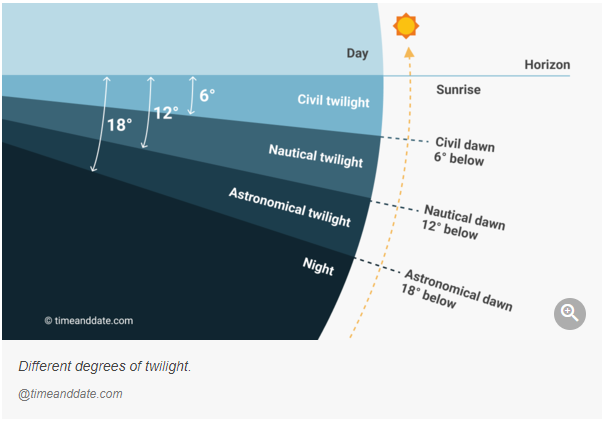
Hallo folks, we have in the mission editor the possibility to show the position of sun and moon over horizon. But when you want to set up a cool lightning in dusk or dawn you need also the position below the horizon. I have attached a picture which shows the different kind of darkness referring to the degree below the horizon. I think it would be a easy improvement to show also the -90° vertical axis in mission editor.
-
[INVESTIGATING] Initial Point is not shown on the CAS page
buur replied to buur's topic in Problems and Bugs
Today I fly a mission and the initial point was on the CAS page. At the moment I have no idea why but will have a eye on this problem and report any ideas. -
Add a new version: Now the scrip will not recognize late activated units. The script finds now EWR script in first post is actualized
-
I can read out the MIST database with mist.getGroupData to get information like frequencies. But when the planes are late activated, there are no information in the MIST database. Is there a way to refresh the database to get this informations?
-
When JTAC send a nine liner with an IP (initial point) the IP is not shown on the CAS page.
-
If you add an EWR in mission editor the EWR has the callsign from the JTAC. When you contact the EWR you get the answer from an AWACS callsign. If you use a JTAC callsign which not correspondents to an AWACS callsign the EWR is broken. Axeman → Overlord Darknight → Magic Warrior → Wizzard Pointer → Focus Eyeball → Darkstar Moonbeam → EWR not working Whiplash → EWR not working ...
-
Add radio frequencies to JTAC and AWACS comm menu item
buur replied to Stone's topic in DCS Core Wish List
I'm working on a small script that will show the AWACS and JTAC frequencies. Maybe you give it a try. -
reported earlier Dedicated Server liveries are missing
buur replied to Buzzer1977's topic in Multiplayer
@zildac your right, the liveries must not on the server but on the clients.