
Sinclair_76
-
Posts
397 -
Joined
-
Last visited
Content Type
Profiles
Forums
Events
Everything posted by Sinclair_76
-

DML - Mission Creation Toolbox [no Lua required]
Sinclair_76 replied to cfrag's topic in Scripting Tips, Tricks & Issues
And if the bombrange trigger zone is 100m in radius. Does i.e. 95% quality mean 5m off center of the bombrange trigger zone? -
DML - Mission Creation Toolbox [no Lua required]
Sinclair_76 replied to cfrag's topic in Scripting Tips, Tricks & Issues
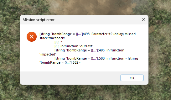
I have a small request. Is it possible for the bombrange to show meters in stead of percentage? Would a clip distance of 100 translate % to meters directly? Or is is the size of the trigger zone? and I get this message when the gbu-38 hits the ground.
-
Fast takeaway. The second document provided pretty much all the info we need on page 28&37. There are four elements that contribute to JDAM system accuracy: 1) the JDAMs ystem components, including guidance hardware and software; 2) the delivery aircraft transfer alignment time hand-off accuracy, including location and velocities; 3) the GPS satellite error; and 4) the target location error (TLE) and the associated coordinate format. And... Once GPS-aiding is accomplished, the aircraft hand-off error is removed and is not a factor in system accuracy. Furthermore (page 37)... The handoff of high quality GPS information to the bomb, allows the JDAM to achieve full position and velocity acquisition within a maximum of 27 seconds and full GPS navigation within 28 seconds after release. This document states that after a gps handoff and roughly 28 seconds after release the aircraft error is not a factor anymore. Thank you @KlarSnow!
-
The 13m CEP comes from the F-16.net site. It was one the earlier established CEP prior operation Allied Force. Later finetuning of the Kalman filter resulted in a 5m CEP. @Lord Vader It doesn't matter how you spin it, NATO documents provided (ATP 3.3.2.1 (NATO UNCLASS) 3.32 BOC and IAMS), clearly state that the only factors that determine the outcome of a JDAM release are the CEP and TLE. Nothing references to the launching platform or their location error. I stand by that with a functioning gps on the F-16 the JDAM CEP is 5m and that a location confidence of 30m or ,10m ,for that matter, don't influence the accuracy of a JDAM. The only reason I provided the F-16.net info is to fill in the gaps, not be used as a red herring.
-
The JDAM GPS kicks get it's first fix +/-10 sec after release. It then takes some time for the Kalman filter to wash out the launcher location error to get to the 5m CEP. Best open source I could find is F-16.net (see link below). The link is slightly dated, the Kalman filter has been improved to further reduce the 13m CEP to 5m CEP (2016 SAR document below). Sure the F-16 INS/GPS might develop a 30m error (which is a lot, the aircraft I used to work with had a position confidence of 15m) but the JDAM does not take the full error to the ground if employed correctly. To suggest that the F-16 error of 30m translates in a 30m (error)+5m (CEP) is just incorrect (see sources below and explanation above). In IAMS targeting TLE and CEP are considered, not the launcher location error. The JDAM is adverse weather and BOC (bomb on coordinate) capable. Especially with BOC the pilot only fat fingers in the coordinates and releases in optimum parameters. Hence that during CAS the only action required for correlation is the readback of the programmed coordinate in the system. In case of the F-16 you readback what you entered in the DED, not what you wrote down. To fiddle around with TGP to update the coordinates would invalidate that procedure (Aircrew will not modify coordinates once read back is complete). Sources: https://www.f-16.net/f-16_armament_article9.html https://apps.dtic.mil/sti/tr/pdf/AD1019464.pdf ATP 3.3.2.1 (NATO UNCLASS) / 3.9.1 BOC / 3.32 BOC and IAMS / 5.4.15.a BOC Correlation / H.5.g Correlation and Tholozor
-
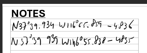
The new navigation alignment for the F-16 is not accurate enough for pre planned GBU-38 delivery. Did a full INS alignment in open air according new procedures. Aligned GBU-38 on the ground. Verified target coordinates and corrected longitude (top coordinate on kneeboard). You can verify with miz file Once airborne delivered a GBU-38 on preplanned target. Target not destroyed. Although this trackfile is only on run I did many, none hit the target. Than proceeded for a TOO delivery. 1st TOO GBU-38 was fault on my side. 2nd TOO was a hit. You can crosscheck coordinates with kneeboard (lower coordinate). This means that in this configuration the F-16 can't deliver GBU-38 through bomb on coordinates CAS procedure. Or deliver a GBU-38 in a near peer environment with a low level toss. Personally I find it strange that the GBU-38 itself has a 5m CEP. But that F-16 is not capable of exploiting that degree of precision because it's INS/GPS isn't as accurate. TEST - NAV FULL ALIGN PP GBU38 delivery.trk Test - NAV-TGP.miz
-
I will. And I know how. But as far as I can tell preplanned JDAM targets are inaccurate.
-
So I've tested this. Mission setup 2 targets and my player aircraft. One steerpoint over first target. Double checked altitude. I did a full NAV line up with the aircraft on a platform, not in a bunker, using GPS according new procedures. All systems display a high accuracy in the DED. Made sure the GBU-38 did a full lineup (READY MSG) Once airborne the TGP slaved roughly 50 meters to the west. The GBU-38 falls roughly on that, 50m west of target, position. Update the tgt with an TMS up results in the 'normal' 5m CEP. And subsequent tgt kill. An air start resulted in a different issue. It seems like the target altitude is incorrect / too high. Before tgt the tgp is aiming too high and straight above the error seems almost 0. Funky stuff. I've some more testing to do so no replay just yet. But it's like 2 steps forward 3 steps back with the F-16.
-
Eagle Dynamics does not only replicate accurate aircraft systems but they accurately replicate the bureaucracy and information management involved in operating aircraft as well. Not even joking btw. In both my flying jobs Airforce (long time ago) and airline, this is a huge problem. On my finiflight I busted a regulation, which I didn't know existed; Wing Operations briefed it when I was deployed they forgot to to update the local area folder they forgot to update the master maps, and remove old out of date maps from the NAV room. After landing I normally shred my maps but somehow I held on to it for CYA purposes. When the investigation started I could objectively show that the info on the maps, provided by the nav department, was outdated. than they tried to pin it on me that I didn't crosscheck the information with the master navigation manual, of which there is only one, located at wing ops. But in the end wing ops couldn't find the regulation requiring me to verify that manual in their SOP, so the fined the daily operations officer instead. Happy days, after 15 years of Airforce my CYA fu is as honed as my flying skills.
-
You could've left your trim in DISC during the start up. That would explain both issues.
-
correct as-is my noob f16 problem, datalink and landing
Sinclair_76 replied to Suffer_Player's topic in DCS: F-16C Viper
Iirc for a repair you have to completely shutdown the aircraft. After that you need to do a full IRS realignment (the 8 minute one). Don't forget to enter the lat as well as the long. Default values are fine. -
Congratulations to me.... Woke up my family laughing...
-
@IR.Clutch How does the INS error show? What do you intend to demonstrate with the red arrow in your description?
-
No, works fine for me. But the JTAC supplies me with 8 digit MGRS with an 100k square identifier. It omits the gridzone designator though. Ie Nevada is 11S (which never gets mentioned) NB 1234 5678. You enter everything as is. Don't bother adding the extra zeros it accepts 8 digits, it's not that ghetto. What sometimes happens is that the grid leads with a easting zero. DCS omits that zero in the teadback and you get a 7 digit grid. That's the only time I will add zero's in the while entering MGRS coordinates.
-
That could be very well be but in that case it should also work with 2x receivers imo, just need extra time to compensate.
-
I don't consider BN's reply a real answer. He only stated documents reference they need 3x emitters. I asked for a reason why. Of course it's possible he can't give a reason, which is fine. At least three receivers is neither fish nor fowl. A true TDOA solution requires 4x receivers (=3x TDOA). If a solution only requires 3x receivers, my bet is the system uses a Kalman filter to get a fused location using ,3x receiver TDOA ( a curve) and multiple triangulation ellipses (the location is where the curve touches the ellipse or DTED as suggested by @toilet2000). But then this system would also work with 2x receivers (the location is where the hyperboloid touches the ellipse, if there is overlap there is a significant reduction of the area where the true location is at). The beauty of a full TDOA location it's that it is near instant high accuracy. Any location fusion with less than 4x receivers just requires (a lot of?) more time to get proper measurements and have the Kalman filter come up with a precise location. or ED interpreted the 3x TDOA as 3x receivers.
-
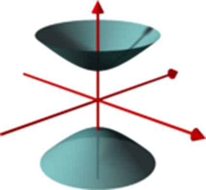
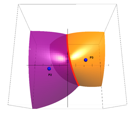
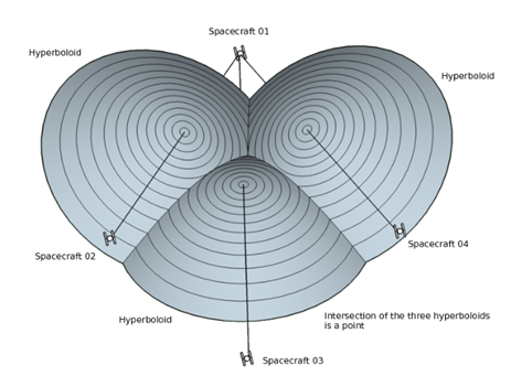
The solution provided does not answer my question and is incorrect. TL;DR There are multiple variations on solving emitter locations with multilateration. In this case KlarSnow conflates 3d true-range multilateration, in the text and 2d TDOA/ pseudo-range multilateration with the visual example (both 3 receivers). But the problem in localizing a hostile emitter in DCS is a 3d TDOA (not a true-range 3d or a pseudo-range 2d) problem which according to the formula for pseudo-range multilateration, m≥d+1 (m=receivers, d=dimensions) requires at least (3+1=) 4 receivers. Hence my question; how does ED solve the 3d TDOA problem with 3 HTS equipped Vipers when technically 4 receivers are required? Now for my lengthy/nerdy explanation. Multilateration is difficult subject. To begin there are two distinct problem sets. Multilateration with known ranges, true-range multilateration, with unknown or biased ranges, known as pseudo-range multilateration. True-range multilateration can be done with radars for example. With just range 2 emitters can locate a target in a 2d situation. With 3 emitters a target can be defined in a 3d environment. With the HTS and passive equipment in general, ranges cannot easily be obtained. Time Differences of Arrival (TDOA) can be used to overcome the ranging problem. TDOA is typical for pseudo-range multilateration. The formula used to determine the amount of receivers to determine the location of the emitter is: m≥d+1 (d are the amount of dimensions being dealt with, and m the amount of receivers). To put it simply a TDOA solution in a 2d environment requires 3 receivers and a 3d environment requires 4 receivers. In passive equipment (yes there are exceptions but only in a cooperative environment) a single station, when receiving an emission, can only establish that an emitter exists. It can’t determine range or location for that matter (by using directional antenna’s you would be able to determine direction). A single TDOA requires at least two Times of Arrival (TOA). In other words, a single TDOA requires a minimum of two receivers. With a single TDOA a pseudo range can be determined which can be plotted on a half of a 2-sheeted hyperboloid (either the top or bottom in the picture). Adding a third receiver adds a second TDOA and hyperboloid. The location of the emitter in this case is on the curve (in red in the picture below) that intersects two hyperboloids. Adding a fourth receiver will have the previous curve intersect with the hyperboloid on a single point (most of the time as I understand it but apparently it sometimes can intersect in two points. I might be wrong here as I don’t fully understand this part). The point is the location of the emitter. With the visual examples as well as the formula I hope to demonstrate that locating an emitter with TDOA in a 3d situation requires 4 receivers. In the video by Matt, it is mentioned that at least 3 Vipers with HTS pods are required. To come back to my original question; how does ED tackle the TDOA equation with only 3 receivers? In the above quoted part it’s clear that KlarSnow is referring to 3d true-range multilateration and not pseudo-range multilateration. The picture provided references a 2d (on a single plane) TDOA which also only requires (2+1=) 3 receivers. The TDOA problem in DCS is a 3d pseudo-range multilateration so both the written as well as graphic representation provided in the solution don't apply. Further reading: https://en.wikipedia.org/wiki/Trilateration https://en.wikipedia.org/wiki/Pseudo-range_multilateration Graphics: https://en.wikipedia.org/wiki/Hyperboloid https://math.stackexchange.com/questions/2629499/intersection-between-two-hyperboloids https://math.stackexchange.com/questions/3379193/intersections-of-3-hyperboloids
-
In the recent ED Matt video of the HTS improvement, it was mentioned you need at least 3x Vipers to get a TDOA solution. What is the reason for that? Edit: my mistake report in bugs wasn't intended. Please move to general.
-
The way I interpret this is that a AG radar handoff is already as accurate as it can get. Makes sense because unlike the laser it's constantly ranging already.
-
DML - Mission Creation Toolbox [no Lua required]
Sinclair_76 replied to cfrag's topic in Scripting Tips, Tricks & Issues
Might I suggest another improvement? The effects themselves are all the same. n Sure after fireFx in the zone description you can enter the required size. Would it be possible to enter "r" or "rnd" in the description so that DML then randomizes effects (fire / smoke), effect sizes (S/M/L/XL) and smoke density? To develop it further combine it with spot zone destruction. So you have randomized smoke/fire and combine it with say 60% (user changeable) of the objects at the fire/smoke destroyed? This would quickly add a lot of grittiness to scenario's that is randomized.
-
DML - Mission Creation Toolbox [no Lua required]
Sinclair_76 replied to cfrag's topic in Scripting Tips, Tricks & Issues
Is there a way to randomize the position of FireFX in a zone? -
DML - Mission Creation Toolbox [no Lua required]
Sinclair_76 replied to cfrag's topic in Scripting Tips, Tricks & Issues
My bad. I forgot the reconModeConfig. It is properly mentioned in the DML Documentation but not really in the DML Quick Reference. -
DML - Mission Creation Toolbox [no Lua required]
Sinclair_76 replied to cfrag's topic in Scripting Tips, Tricks & Issues
Yup latest versions and imperial as well as mgrs to true. -
DML - Mission Creation Toolbox [no Lua required]
Sinclair_76 replied to cfrag's topic in Scripting Tips, Tricks & Issues
cfxReconMode still returns altitude in meters and latlong even when MGRS and imperial is set to true. Is there a way to change it? -
correct as-is HAD - problems locking emitters also in Caucasus
Sinclair_76 replied to Sinclair_76's topic in Bugs and Problems
Ahh there is a whole new logic to it. Makes sense now. What also changed is the behavior of the HAD designation. You used to be able to SOI the TGP and move it around without losing the HAD designation when SOI-ing the HAD again. Now it loses the designation the moment you move the TGP. Switching fov, either way, or changing sensor type holds the HAD designation.