itn
-
Posts
172 -
Joined
-
Last visited
Content Type
Profiles
Forums
Events
Everything posted by itn
-
Help getting highest INS accuracy for pre-planned popups
itn replied to Nealius's topic in DCS: F-16C Viper
To test if FIX works or not, there are two easy ways 1) Active Pause and time acceleration. You can literally see the diamond moving in HUD. Wait for it to drift enough and try doing a FIX. [EDIT: This worked previously, haven't tested with current version.] 2) Purposefully offset steerpoints in mission. Add an air-spawn airplane group and put the steerpoints exactly on the targets (the correct position, atop the target or on runway threshold or whatever) Copy the group and paste it offset from where the original group was. Make the offset large enough for you to notice, and for anyone to notice it visually looking at the track or video. Optional: If you want to do this from cold start jet, set the spawn point to Start from ramp. Spawn, fly and try using FIX. FIX did work in e.g. 2022 and early this year before the INS upgrades (in Caucasus and Syria). -
Help getting highest INS accuracy for pre-planned popups
itn replied to Nealius's topic in DCS: F-16C Viper
Perhaps this would have been sufficient in your reply. I hope the thread won’t get locked quite yet, because there are likely some implementation details and nuances worth discussing. OP’s problems are solved but to me it seems there might be some details worth proper discussion. -
Help getting highest INS accuracy for pre-planned popups
itn replied to Nealius's topic in DCS: F-16C Viper
Videos/tracks are just very, very useful to rule out user error. At least previously (before April's INS+GPS+Kalman filter overhaul), doing FIXes with GPS on was pretty much useless. The GPS would just override any changes you made. I don't know if this specific detail has been changed or if it still works like that, and FIXes with GPS are still counterproductive. The system should likely take into account the better accuracy of a recent FIX instead of simply overwriting it with GPS. So if your mission has the steerpoints offset to begin with (to simulate an INS drift), try disabling GPS and try again. Do a FIX on the first one and then see how the rest are. For video and track purposes it helps to make the offsets or corrections large enough for them to be really noticeable. -
Help getting highest INS accuracy for pre-planned popups
itn replied to Nealius's topic in DCS: F-16C Viper
Video and a track would go long way to see and understand the issue and your procedure more clearly. -
+1 Yes, please add this. Similar to an earlier thread which calls for the ability to restrict both Link 16 and JHMCS.
-
+1 The ability to restrict Link-16 and JHMCS would go really long way for adding versatility to the DCS F-16C. Mission Makers could make more believable early F-16 variants by using Loadout Restrictions, and these proposed restrictions. Many, many historical scenarios call for an earlier F-16 variant, and these restrictions would go really long way towards that. I know we're not getting another variant, nor Sparrows, nor NAVFLIR etc. But I do hope we could get the ability to restrict some of the functionality we have. If not now, maybe after Early Access.
-
Hi, Running DCS 2.9.7.59263. Low-flying Kh-65 cruise missiles have some kind of smoke or vapor trail looking like a contrail. Not sure if they should have it at all, but the issue here is the trail visibility. It is quite broken and heavily dependent on zoom level. See the attached track for demonstration. In essence, when zooming out, sometimes at full zoom out, you can see the trails, but on more normal zoom levels, they just disappear. Zoom level and, I believe, distance effects the issue. I think there's a similar issue with contrails on high-flying airplanes. But this report and track is for Kh-65 cruise missiles only. Best regards, itn KH-65 contrail or smoke visibility.trk
-
Or just pad the numbers, such as 01,02,03... or 001,002,003...
-
need evidence FCR TGT speed/closure bug or feature?
itn replied to Carbon715's topic in Bugs and Problems
I talked about target speed, not closure rate, being CAS. I believe CR as TAS is correct and make no claims about it. For the target speed, I can only refer you to your own references and just ask you to re-check them. There are no documents that I know of that would satisfy your publicly stated requirements for evidence. However, I have been lead to believe the other well known and widely distributed F-16 manuals for other variants/nations all state the same thing: FCR in CRM(/SAM/RWS/TWS) shows target speed in calibrated airspeed. But again, those docs are not for 2007 USAF/ANG block 50 CM so I will just have to ask you to re-check your own references for the correct variant. Maybe it differs or maybe it doesn't. Would have to re-test but IIRC last time I tested in DCS, it showed Ground Speed, not TAS nor CAS. Basically I chased a target in a heavy wind, and when closure was 0 per FCR, HUD and visually, the FCR target airspeed readout matched GS in my HUD perfectly. TAS not so much because of the wind, and CAS even less so because of altitude effects. Best regards, itn -
need evidence FCR TGT speed/closure bug or feature?
itn replied to Carbon715's topic in Bugs and Problems
IIRC FCR shows target speed in Ground Speed instead of CAS. I think it should show CAS and that this was reported long time ago with no results. -
cannot repoduce and missing track file F-16C Contrast of MFD
itn replied to Hikaruncat's topic in DCS: F-16C Viper
Have not seen anything like this. However, bear in mind the different pages and/or types of displays have independent brightness/contrast/symbology settings. For example, if you adjust the brightness on SMS and switch to WPN, the WPN has its own independent brightness and contrast settings. Maybe this is what you saw, or are you sure you noticed the brightness/symbology decreasing on one single MFD page? External/environmental lighting also obviously plays a role. Like the sun rising or setting, or hitting the screens can of course necessitate brightness/contrast adjustments. -
My comment about documenting the GPS gotchas was mostly meant in general, not only F-16 and not only for the dozen of us who actually closely follow the Viper Mini-updates. I like the mini-updates and for those that follow them, they’re the best way to stay current with the changes. Thank you for those. However, if I remember correctly (checked before I sent my previous message), the GPS cut-off date and coalition degradation is mentioned nowhere in the DCS User Manual. Text on Unrestricted SATNAV says what it does, but does not detail what are the restrictions that gets unrestricted. What I had in mind in my comment is the budding mission maker, not knowing all the ”just need to know” gotchas and not following e. g. Viper mini-updates. The one we found in this thread is just the newest gotcha found out more or less accidentally. Also I’ll mention that apparently Russia has some GPS keys to share even if blue does not. If you have blue without USA versus Russia and others on red, blue Vipers get no GPS as we established, but red Vipers get the degraded red GPS. Even if the key/coalition/faction simulation might make some sense overall, you’ll quickly find yourself in weird technicalities that make no sense even if the mission scenario might be believable. Just my two cents.
-
Thanks for the information. Without going into a longer critique/wish/rant here, the GPS degradation/availability details really ought to be properly documented and preferably shown in Mission Editor / game UI somewhere for mission editors and players to see. IMO they ought to be re-evaluated, which maybe you will do at some point. Meanwhile we have Unrestricted SATNAV which we can use to bypass all that, so not that big of an issue.
-
I believe the issue stems from not having USA in the coalition. I don’t have a track and didn’t check any of the previously posted ones, but I encountered this on a mission. When BLUE had only CJTF Blue, Norway, Sweden, Finland, my Norwegian Viper had no GPS. Only after I added USA to the blue, the GPS on Norwegian Viper started working. Blue: CJTF Blue, Norway, Sweden, Finland - no GPS for Norwegian F-16s Blue: CJTF Blue, Norway, Sweden, Finland, USA - yes GPS for Norwegian F-16s Will add track later if needed.
-
investigating JDAM doesn't use elevation of target and still hit target
itn replied to Strannix's topic in Bugs and Problems
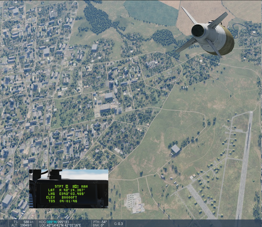
Hey, Couldn't replay your track so re-created my own. First one has mere 3000 feet for STPT 2. Second one is more extreme, where the STPT 2 is set at 20 000 feet and I pickle from about 40 000 feet. nullAlso attached a screenshot showing the difference in coordinates when bomb in flight is at around 20 000 feet (so basically when it should have already hit its "target" at the STPT 2 coordinates/elevation. I suppose this is related to the absolute/relative targeting of JDAMs, but as you said, it seems altitude is completely ignored in bombs-at-coordinates situation. F-16 GBU-38 PRE elevation.trkF-16 GBU-38 PRE elevation 20kft.trk
-
If you mean the checkbox at AH-64 BLK.II in your 2nd pic, that checkbox is not to make an aircraft type as available for dynamic spawning. That checkbox is for Unlimited amount of that type of aircraft. Notice the infinity symbol on column label. Aircraft is spawnable if the amount < 0, type is unlimited, or if the warehouse has Unlimited Aircraft checked. For your first issue, I wonder if it's some sort of incompatibility. Might want to try a ED carrier for example. I did just a quick test and it seemed not all units are compatible, but I don't have quite the same set as you do. Hope this helps.
-
fixed Displayed waypoint altitude changes on its own when using imperial units
itn replied to itn's topic in Mission Editor Bugs
And thank you. -
fixed Displayed waypoint altitude changes on its own when using imperial units
itn replied to itn's topic in Mission Editor Bugs
Ah, same here: It does not happen when you click on the waypoints themselves. I didn't notice that or test it specifically. In my use case (long story short: editing dozen waypoints for dozen groups flying a carefully planned flight plan) I mainly used the waypoint drop-down menu or arrows to switch. So one more requirement to reproduce: Switch waypoints using the WAYPOINT drop down menu, or the < > arrows next to it: nullnull Can you now reproduce it, @Flappie? null
-
fixed Displayed waypoint altitude changes on its own when using imperial units
itn replied to itn's topic in Mission Editor Bugs
Hey @Flappie. No change, still reproducible in ME in DCS 2.9.4.53990. Make sure you use Imperial units, as the issue seems to be in metric/imperial conversion and rounding. Steps to reproduce: Have DCS use Imperial units (under Settings - Gameplay) Open ME, add an Airplane or a Helicopter Set initial waypoint altitude to 6000 feet Add second waypoint: altitude 300 feet Add third waypoint: altitude 7003 feet Switch between the waypoints and see the altitudes are 6001, 299 and 7005 feet instead of the original values. The values are just examples, you can see it happen with different values if you keep trying. -
reported TGP not powering up after April 10th update
itn replied to Swamp Fox Loader's topic in Bugs and Problems
Thanks Lord Vader. I assume and expect you'll come into a good solution. Even though there's some discussion here, I don't think this is a very complex question. My two cents, also replying to some of the posters above: The loadout selection is simply a game mechanic, and far removed from any "realistic" way jets are loaded. This is just a fact and not a criticism of any kind, this is a game and some things cannot be "realistic". As such, in my opinion it's best to simply follow good principles of system/interface design, mainly the principle of least surprise, which in this context means this: You have a jet with all the pod power switches (station power + L/R HDPT) on. You add a pod. You expect to have all the power switches on, pod added, pod has power. Instead of, the unexpected: You have a jet with all the pod power switches on. You add a pod. One or more of the power switches are now switched off. You now have a pod with no power on; even though you started from a situation with the power switch on, and simply tried to add the pod. Or, the objectively outright wrong: You have a jet with all the pod power switches on. You add a pod. You have a pod, and all the power switches on, but the pod has no power. This would be a bug. Br, itn -
cannot repoduce and missing track file Storage alignment with autostart
itn replied to Toro's topic in DCS: F-16C Viper
INS drifts regardless of the initial alignment type. It’s also modelled in DCS F-16C, even if in a simplistic manner. However, we get an INS re-work in today’s patch, so some of the DCS-specific details are bound to change. -
Pressing COM1/2 and ENTR does not switch between ”preset/frequency modes”. ENTR without inputting a preset/freq switches to the last used channel, and can be used for pogoing to another channel and back easily. Preset channels and manual frequencies can be switched into in the exact same way (COM1/2, preset/freq, ENTR). There’s no ”mode” to change per se. If you really wish to cycle through the presets with selector switch, you can, but it’s faster to just enter the preset number and press enter.
-
reported earlier Pylon weight excluded in re-arm menu gross weight
itn posted a topic in General Bugs
Hi, Using current DCS 2.9.3.51704. Pylon weight is not included in the Loadout/re-arm menu Gross Weight. Tested with Viper, Hornet and RAZBAM F-15E so I assume it's a generic issue, not with individual modules. And at least for Viper, pylon weight is excluded both for pylon-only and weapon+pylon configuration, so in essence pylons are not counted in re-arm menu at all. Steps to reproduce: Create a mission with plane on ground. Use Viper or another plane with removable pylons. Note the total Gross Weight in Mission Editor. Run the mission, enter cockpit and open Loadout/re-arm menu. Note the GW differs from the weight in Mission Editor. Remove or add pylons. Note the Gross Weight does not change. Expected results: Re-arm menu Gross Weight should change when adding or removing pylons. Attached a track, even if it might be useless for a bug like this. Loadout menu gross weight pylons.trk -
To both of the questions: No, not possible. As far as I know, not possible on the real jet either, but I might be wrong. Also, you didn't ask but no TACAN indications on the HUD either. So it's quite a bit different than, for example, the Hornet. I assume this is an Air Force / Navy difference, where the AF just hasn't had the need for it, at least not enough to spend resources to add them.
-
reported S-300 Missile Flight Path Issues
itn replied to Shadow KT's topic in Ground AI Bugs (Non-Combined Arms)
Just to clarify, are you talking about a feature in the Mission Editor, such as an advanced waypoint action? Or did you refer to the same old scripting ways we're currently doing manually or with the excellent MANTIS/Skynet scripts? I could not see any new features like this in current DCS which is why I'm asking.- 20 replies
-
- 1
-

-
- investigating
- s300
- (and 1 more)