drPhibes
-
Posts
1181 -
Joined
-
Last visited
-
Days Won
2
Content Type
Profiles
Forums
Events
Everything posted by drPhibes
-
Is the "VOR-ILS/OFF/TACAN and OMNIBEARING" selector (switch 21 on p.19 in the manual) set correctly?
-
A relative from Troms refers to everyone living south of Narvik as "søringa", so I guess the southernmost cities with airports in the Kola map would be in southern Norway by that standard
-
Is asking for SEPECAT Jaguar a good idea ? Or not.
drPhibes replied to DmitriKozlowsky's topic in DCS Core Wish List
And from that list, only the Vigen and F1 are "European strike platforms form the 60/70ies". Mirage 2000C: multirole, and entered service in 84. F4E: Not European, and technically it's more of a multirole aircraft than a strike aircraft. Hawk/C101/MB339: trainers with a secondary offensive role. Harrier II: While the AV8B is based on an European design, and a strike aircraft, it is not a 60ies/70ies aircraft (it entered service in 85). -
Navaid models: a few suggestions for improvements
drPhibes replied to drPhibes's topic in Object Bugs
I found a DVOR (without DME) at Kutaisi, which has a much more accurate model. It's basically good enough to pass for both a DVOR with and without a co-located DME.
-
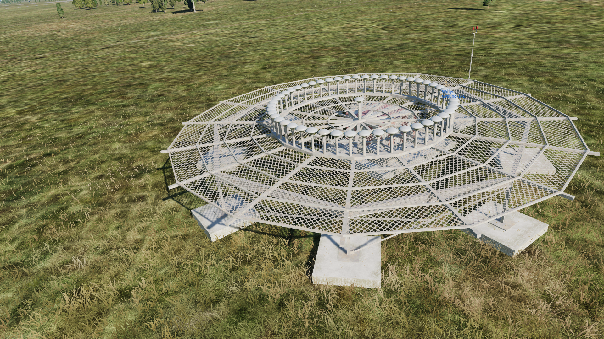
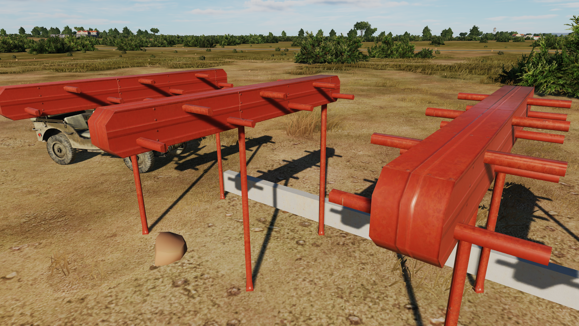
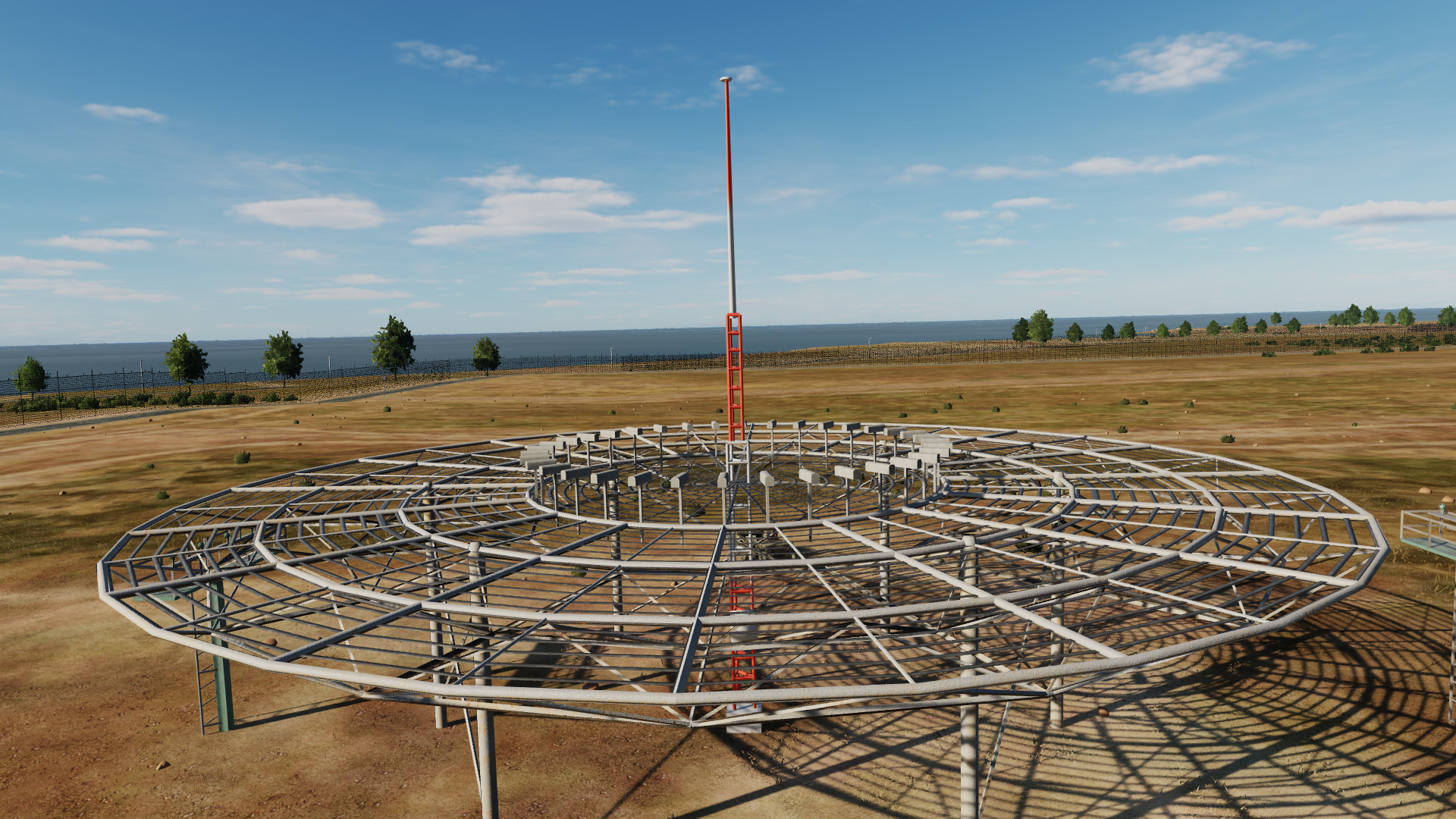
Being a professional in the field (15 years in the r&d dept of a major navaid manufacturer), I have a few suggestions for improvements for the 3d models used in the various DCS maps. All maps use the same models, so I assume that they are part of a standard asset pack for the terrain developers. These are minor details that only the biggest nerds will notice, but I thought I'd let you know anyway. Localizer antenna: The localizer antenna used in DCS is clearly meant to be a log-periodic dipole antenna (LPDA), but the 180° phase shift between each radiating element in the antenna means that it can’t be constructed like the model in DCS, where the staggered up/down position of the radiating elements is symmetrical about the center line of the antenna. This website has a nice figure showing how a LPDA is constructed: https://3g-aerial.biz/en/online-calculations/antenna-calculations/logperiodic-lpda-antenna-online-calculator This is also how all the different localizer LPDAs used by the major ILS manufacturers are constructed. Other than the misplaced radiating elements on one side of the antenna, the general shape of the antenna is fine(-ish). DVOR: The diameter of the counterpoise (the elevated platform that the antennas are mounted on) is a little small (~25m in DCS, while they are ~30m in real life). The 48 sideband antennas should be mounted equally spaced in a ring with a diameter of 13,5m, but in DCS it is ~9m. The sideband antennas are the wrong type. In DCS they are regular horizontal dipoles, but all DVORs use alford loop antennas. The shape of the radomes can vary, but they are usually cylindrical or square with a conical or pyramid top. Here are a few examples (with dimensions in the PDF): https://www.antennas.com/?s=dvor&post_type=product https://net-com.bytom.pl/anteny_lotnicze/AT-DVOR%20011%20en.pdf The DVOR carrier antenna is missing in DCS. It should be mounted in the center of the counterpoise, and it should also be an alford loop antenna. The DME, antenna which sits in the center of the counterpoise in DCS, can be mounted coaxially with the carrier antenna in some cases, but it is also common to place it at the edge of the counterpoise. The lattice mast should not be poking up through the counterpoise.
- 1 reply
-
- 2
-

-

-
What is that mystery fairing under cockpit ?
drPhibes replied to DmitriKozlowsky's topic in DCS: Mirage F1
It looks a lot like the panoramic camera described here: https://www.airvectors.net/avmirf1.html -
If you buy all the regions separately you get exactly the same product as if you buy the complete map, just at a higher price.
-
The following methos works fine: 1. Just copy the whole DCS directory to the new computer. 2. Run a repair. 3. Copy over the \saved games\dcs world\ folder to the new computer, overwriting all files (so you don't have to set up control assignments). Or you could skip step 1 and 2 and do a regular install if you don't mind spending hours downloading potentially hundreds of gigabytes of content all over again.
-
Fail lights and fail ADI after cold start
drPhibes replied to DmitriKozlowsky's topic in DCS: Mirage F1
The turorials do not take months to complete. In fact, they are much quicker than your current trial and failure-method. -
I haven't experimented with RSBN/PRMG personally, but I have been approached by a few people who have started adding them to the Russian airbases, so I assume that it's just as easy as adding ILS and VOR/TACAN. You can find the frequencies for the PRMG/RSBN channels using type = BEACON_TYPE_PRMG_LOCALIZER frequency = 905100000 + 6825000 * (channelNum - 1) type = BEACON_TYPE_PRMG_GLIDESLOPE frequency = 939600000 + 6825000 * (channelNum - 1) type = BEACON_TYPE_RSBN frequency = 801000000 + 1000000 * (channelNum - 1) I think the Mig-21 was released before RSBN/PRMG was implemented in DCS, so LNS chose to use a local beacon database, located in \DCS World\Mods\aircraft\MIG-21bis\Cockpit\Systems\R_NAV_data*.lua. It's similar to what Razbam did with the AWLS system in the Harrier before ICLS was added to DCS.
-
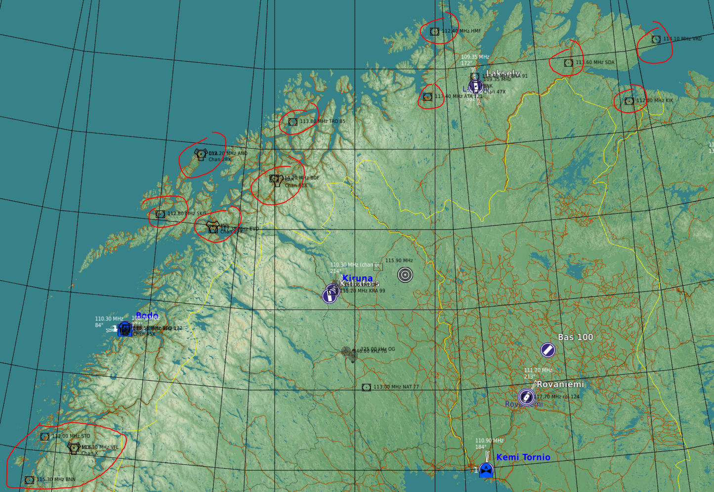
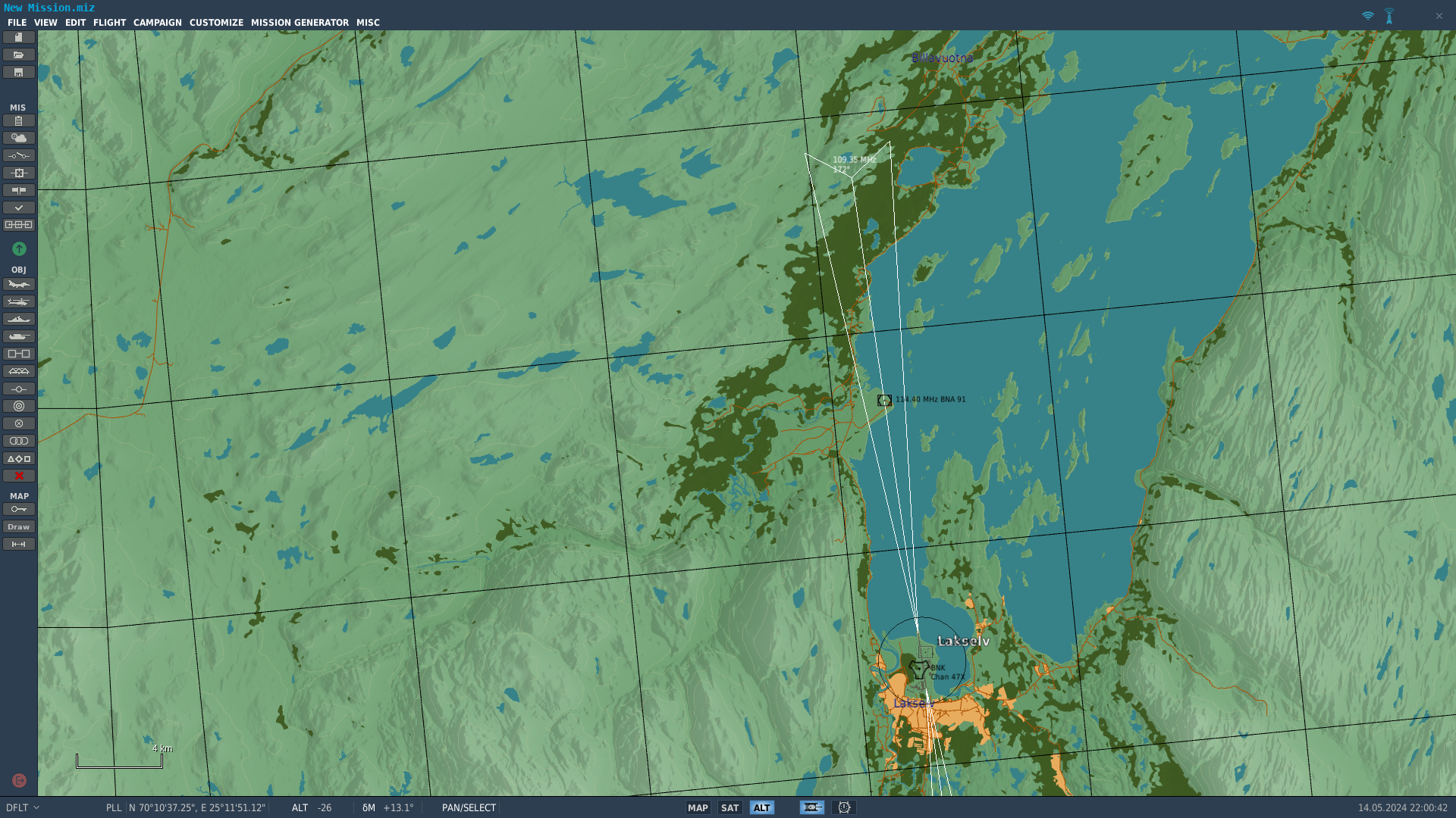
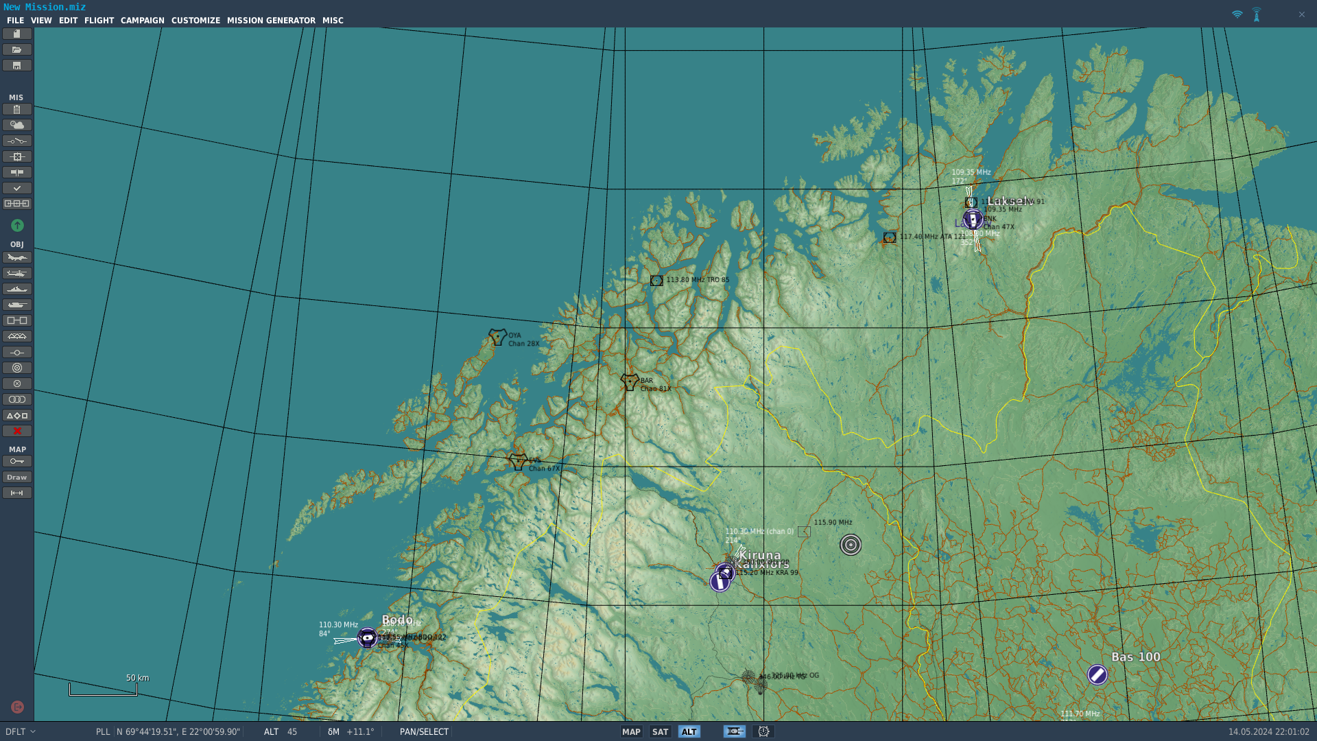
Here's what I've made so far. I have chosen to not publish a complete beacons.lua, since that would revert any improvements made by Orbx if I don't keep it updated, so you'll need to paste the code below into yur beacons.lua file yourself. 1. Navigate to \DCS World\Mods\terrains\Kola\ and make a copy of the existing beacons.lua 2. Open beacons.lua in a text editor, e.g. Notepad++, VS Code or similar. 3. Scroll down to line 185, and delete (or comment out) line 185 to 196. 4. Paste the code below at the end of the file, before the final } -- Bodø: fixed alignment for LOC 07 { display_name = _('BODO'); beaconId = 'airfield7_2'; type = BEACON_TYPE_ILS_LOCALIZER; callsign = 'BO'; frequency = 110300000.000000; position = { -66777.370239, 14.925576, -346636.089121 }; direction = -96.100000; positionGeo = { latitude = 67.205775, longitude = 14.404108 }; sceneObjects = {'t:22119438'}; chartOffsetX = 3703.000000; }; -- Banak LOC 16 { display_name = _('banak'); beaconId = 'airfield1_5'; type = BEACON_TYPE_ILS_LOCALIZER; callsign = 'bk'; frequency = 109350000.000000; position = { 233270.852105, 1.404329, 88608.212175 }; direction = -8.267315; positionGeo = { latitude = 70.054556, longitude = 24.976822 }; sceneObjects = {'t:24846604'}; chartOffsetX = 2898.000000; }; --Evenes TACAN { display_name = _('ENEV'); beaconId = 'airfield13_1'; type = BEACON_TYPE_TACAN; callsign = 'EVS'; frequency = 111000000.000000; channel = 67; position = { 60228.512886, 21, -239542.069812}; direction = 0; positionGeo = { latitude = 68.491286, longitude = 16.675058 }; sceneObjects = {'t:00000000'}; }; --Evenes DVOR+DME { display_name = _('ENEV'); beaconId = 'airfield13_2'; type = BEACON_TYPE_VOR_DME; callsign = 'EVD'; frequency = 117350000.000000; channel = 120; position = { 56431.193858, 37, -239526.363192 }; positionGeo = { latitude = 68.457336, longitude = 16.681939 }; sceneObjects = {'t:000000000'}; }; -- Bardufoss TACAN { display_name = _('ENDU'); beaconId = 'airfield14_1'; type = BEACON_TYPE_TACAN; callsign = 'BAR'; frequency = 113400000.000000; channel = 81; position = { 117734.736203, 106, -159002.606530 }; direction = 0; positionGeo = { latitude = 69.045764, longitude = 18.586586 }; sceneObjects = {'t:00000000'}; }; -- Bardufoss DVOR+DME { display_name = _('ENDU'); beaconId = 'airfield14_2'; type = BEACON_TYPE_VOR_DME; callsign = 'BDF'; frequency = 114200000.000000; channel = 89; position = { 120058.40325, 167, -163708.159663 }; positionGeo = { latitude = 69.064883, longitude = 18.466397 }; sceneObjects = {'t:000000000'}; }; -- Andøy TACAN { display_name = _('ENAN'); beaconId = 'airfield15_1'; type = BEACON_TYPE_TACAN; callsign = 'OYA'; frequency = 109100000.000000; channel = 28; position = { 150255.640500, 4, -254222.831391 }; direction = 0; positionGeo = { latitude = 69.286269, longitude = 16.143767 }; sceneObjects = {'t:00000000'}; }; -- Andøy VOR+DME { display_name = _('ENAN'); beaconId = 'airfield15_2'; type = BEACON_TYPE_VOR_DME; callsign = 'AND'; frequency = 112200000.000000; channel = 59; position = { 150435.995162, 6, -254305.101072 }; positionGeo = { latitude = 69.287822, longitude = 16.141328 }; sceneObjects = {'t:000000000'}; }; -- Tromsø DVOR+DME { display_name = _('ENTC'); beaconId = 'airfield16_1'; type = BEACON_TYPE_VOR_DME; callsign = 'TRO'; frequency = 113800000.000000; channel = 85; position = { 190386.747391, 145, -140242.220054 }; direction = 0.000000; positionGeo = { latitude = 69.702814, longitude = 18.996797 }; sceneObjects = {'t:00000000'}; }; --Alta DVOR+DME { display_name = _('ENAT'); beaconId = 'airfield17_1'; type = BEACON_TYPE_VOR_DME; callsign = 'ATA'; frequency = 117400000.000000; channel = 121; position = { 221498.954094, 1, 27908.980714 }; direction = 0.000000; positionGeo = { latitude = 69.977478, longitude = 23.371758 }; sceneObjects = {'t:00000000'}; }; -- Vardefjell (Mosjøen) DVOR+DME { display_name = _('ENMS'); beaconId = 'airfield18_1'; type = BEACON_TYPE_VOR_DME; callsign = 'VFL'; frequency = 113300000.000000; channel = 80; position = { -215654.999771, 618, -412765.810931 }; positionGeo = { latitude = 65.879508, longitude = 13.307842 }; sceneObjects = {'t:000000000'}; }; -- Mosjøen DVOR+DME { display_name = _('ENMS'); beaconId = 'airfield18_2'; type = BEACON_TYPE_TACAN; callsign = 'MOS'; frequency = 113900000.000000; channel = 86; position = { -215852.697984, 616, -412763.685831 }; positionGeo = { latitude = 65.877756, longitude = 13.308417 }; sceneObjects = {'t:000000000'}; }; -- Kirkenes VOR+DME { display_name = _('ENKR'); beaconId = 'airfield19_1'; type = BEACON_TYPE_VOR_DME; callsign = 'KIK'; frequency = 112000000.000000; channel = 57; position = { 216335.661881, 84, 279276.143526 }; positionGeo = { latitude = 69.723786, longitude = 29.869081 }; sceneObjects = {'t:000000000'}; }; -- Vardø VOR+DME { display_name = _('ENSS'); beaconId = 'airfield20_1'; type = BEACON_TYPE_VOR_DME; callsign = 'VRD'; frequency = 114100000.000000; channel = 88; position = { 293231.183127, 8, 312737.43914 }; positionGeo = { latitude = 70.357628, longitude = 31.047253 }; sceneObjects = {'t:000000000'}; }; -- Sandnessjøen DVOR+DME { display_name = _('ENST'); beaconId = 'airfield21_1'; type = BEACON_TYPE_VOR_DME; callsign = 'STO'; frequency = 112000000.000000; channel = 57; position = { -201777.511861, 28, -449522.901048 }; positionGeo = { latitude = 65.960286, longitude = 12.469314 }; sceneObjects = {'t:000000000'}; }; -- Brønnøy DVOR+DME { display_name = _('ENBN'); beaconId = 'airfield22_1'; type = BEACON_TYPE_VOR_DME; callsign = 'BNN'; frequency = 115300000.000000; channel = 100; position = { -255826.390352, 2, -468859.820763 }; positionGeo = { latitude = 65.457086, longitude = 12.214417 }; sceneObjects = {'t:000000000'}; }; -- Hammerfest DVOR+DME { display_name = _('ENHF'); beaconId = 'airfield23_1'; type = BEACON_TYPE_VOR_DME; callsign = 'HMF'; frequency = 112400000.000000; channel = 71; position = { 302980.063217, 367, 36499.561332 }; positionGeo = { latitude = 70.704192, longitude = 23.690586 }; sceneObjects = {'t:000000000'}; }; -- Stokmarknes VOR+DME { display_name = _('ENSK'); beaconId = 'airfield24_1'; type = BEACON_TYPE_VOR_DME; callsign = 'SKG'; frequency = 112800000.000000; channel = 75; position = { 75496.377074, 1, -305477.120326 }; positionGeo = { latitude = 68.578325, longitude = 15.034969 }; sceneObjects = {'t:000000000'}; }; -- Seida VOR+DME { display_name = _('Seida'); beaconId = 'airfield25_1'; type = BEACON_TYPE_VOR_DME; callsign = 'SDA'; frequency = 113600000.000000; channel = 83; position = { 263860.883040, 272, 203621.362394 }; positionGeo = { latitude = 70.234261, longitude = 28.070178 }; sceneObjects = {'t:000000000'}; };
-
Maybe your time would be better spent by reading the manual (or Chuck's guide)? It's a much more efficient way of learning than trying, failing, and asking on the forums for every single feature in the aircraft.
-
What makes you think that the 3D artist responsible for making the pilot model would have been working on the code related to the DTC or Lantirn if the pilot body wasn't a priority? It's like expecting a plumber to fix the electrical wiring in your house.
-
Unless ED have changed the way the IC works since my last beacon mod several years ago, it will not pass IC.
-
Yes.
-
All the VOR+DME (13) and TACAN (4) sites in the area have been added. Now I just need to check if they all work.
-
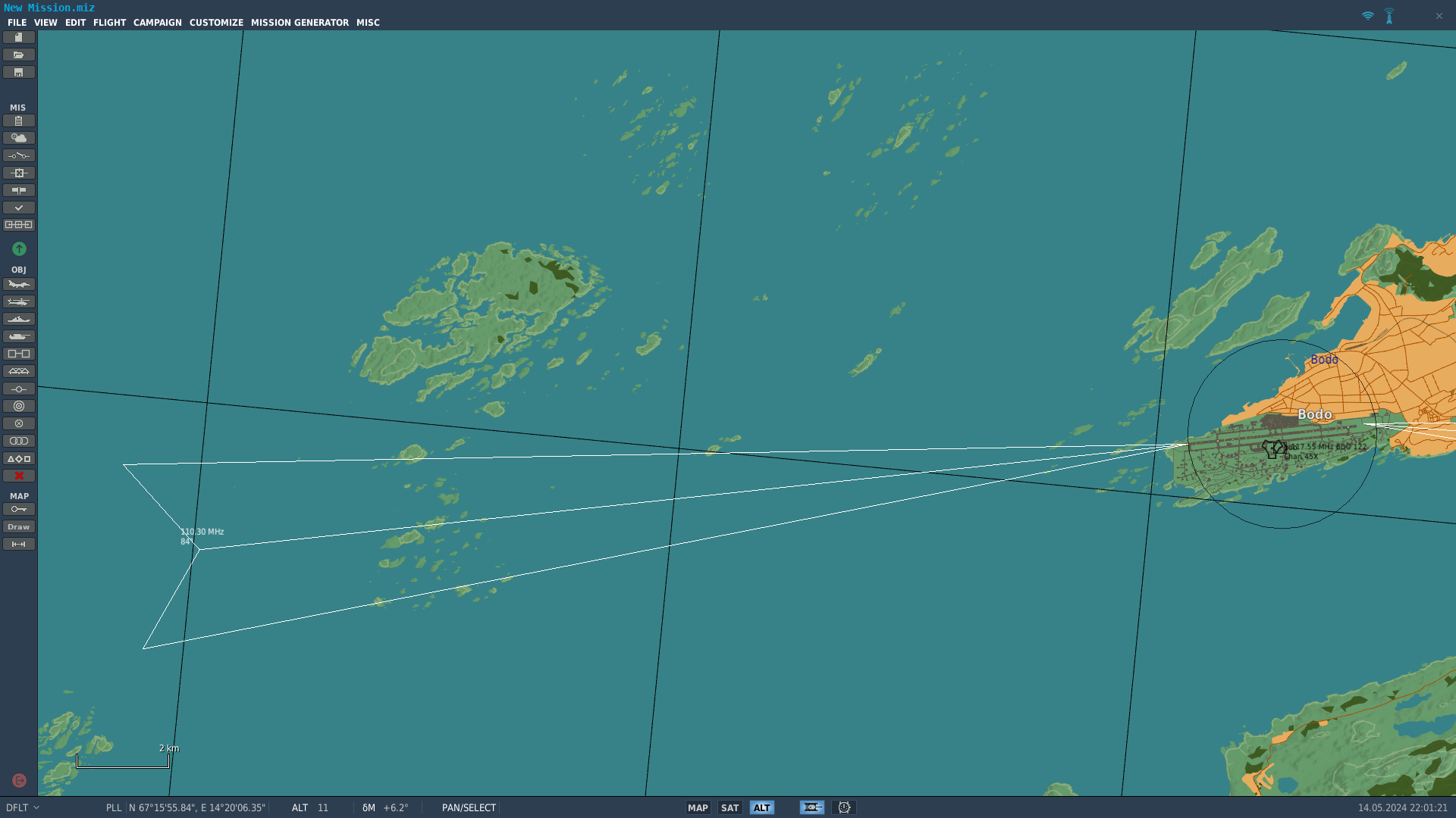
I'm too impatient to wait for all the missing airports (with their associated navaids) to be added to the Norwegian part of the map, so I have started adding a few TACANS and DVOR/DMEs to help with navigation when flying along the coast. I have also fixed (or at least improved) the crooked LOC07 at Bodø, and added the missing LOC16 approach to Banak/Lakselv. Nothing is ready for release yet, but if anyone is interested, I can see if I can get something done during the weekend.
-
Not exactly. The DME that is paired with the 112.4 MHz VOR is on the same frequency as the TACAN, but no part of the TACAN operates on 112.4.
-
https://www.forsvarsbygg.no/globalassets/vi-tar-vare-pa-miljoet/skytefelt/setermoen/kart-setermoen-sof.pdf The areas markes "nedslagsfelt" in the maps are the general target areas. https://kart.finn.no/ (click "Flyfoto" in the upper right corner for aerial photos, and you can find older photos under the "Historiske" menu to the left) has better aerial photos than google maps, so you can use that for finding the targets . They are quite easy to find along the road going east from the range control tower vctpil linked to.
-
Forsvarsbygg (the part of the Norwegian DOD that owns the range, and all other military installations in the country) mention that it is prohibited too shoot or drop bombs from planes at Mauken-Blåtind, so I assume that the no shooting part also covers helicopters. https://www-forsvarsbygg-no.translate.goog/no/skyte--og-ovingsfelt/mauken-blatind-skyte-og-ovningsfelt/?_x_tr_sl=auto&_x_tr_tl=en&_x_tr_hl=en&_x_tr_pto=wapp
-
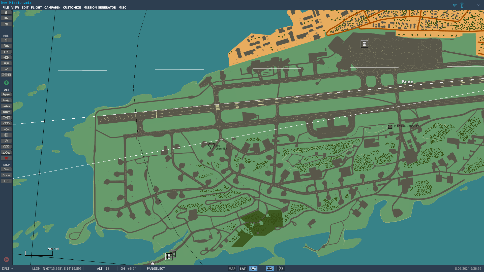
No, LOC 07 is in the correct end, but DCS map makers usually add an offset ("chartOffsetX = " in the relevant entries in beacons.lua) to the shown coverage sector to avoid clutter. Orbx haven't done so to LOC 07. LOC 25 is offset, and located right next to LOC 07, just like in real life.
-
LOC07 is misaligned by approximately 0,5° N according to the mission editor.
-
Do you have any more details on this issue? I don't have the Kola map myself (at least noe yet) so I can't check this, but one of the ILSes at Bodø is in fact offset by 10° IRL. LOC 25 is also located in the "wrong" end of the runway, right next to LOC 07.
-
DCS Kola Real World Helipad Locations
drPhibes replied to Backy 51's topic in Orbx Simulation Systems
It's still there. Google maps has an old photo from before the upgraded helipad was built (for the new AW101 SAR birds). -
Trains are sunken into the track way and wheels do not turn.
drPhibes replied to Rudel_chw's topic in Orbx Simulation Systems
To be fair, in the russian or finnish parts of the map that locomotive wouldn't run at all. Using a standard gauge locomotive on 1520mm (Russia) or 1524mm (Finland) gauge would probably look a bit like your screenshot, since the wheels would be resting on the sleepers/ties, not the rails.- 2 replies
-
- 1
-
-
- bug report
- kola map
- (and 1 more)