drPhibes
-
Posts
1182 -
Joined
-
Last visited
-
Days Won
2
Content Type
Profiles
Forums
Events
Everything posted by drPhibes
-
https://www.digitalcombatsimulator.com/en/downloads/screenshots/572/
-
need track replay ADF frequency submission - ERROR
drPhibes replied to Talvid's topic in DCS: F/A-18C
The last time I checked, the ADF in the F-18 wasn't compatible with regular NDBs. It uses the COM radio, which can't tune to frequencies below ~100MHz. -
-
Note that the active runway for the ILS is not necessarily the same as for the ATC for low wind speeds. Set a headwind of 7kts, and the ILS will switch on.
-
No, they shouldn't. Replacing obsolete software or hardware is a user responsibility.
-
It was basically "Hey, tablets are cool, right? Let's make a hopeless tablet OS for PCs!" Luckily, they came to their senses before making Win 10.
-
What about 8?
-
Just go for the passive aggressive "limited experience" (sic.) and don't connect Win 10 to a Microsoft account when installing. After installing, disable telemetry (there are plenty of guides on how to do that). Using Win 7 on a computer connected to the internet a year after Microsoft stopped supporting it is, to put it mildly, not particularly smart from an IT security point of view...
-
Open up the locked sound file folder to what it has been for 20 years
drPhibes replied to Bob1's topic in DCS Core Wish List
You should probably read §2 in the ED EULA. TL;DR: you have purchased a license to use a piece of software. You do not own the software. -
I use Adblock Plus (for Firefox). I think it's available for most other browsers as well.
-
Are there still people around who don't use an adblocker? I haven't seen an ad on youtube for years...
-
0 wind causes more issues than it prevents. At 0 wind an airport will use the default active runway. If the active runway is a runway direction without ILS, the ILS will be switched off with 0 wind. For airports with ILS for both runway directions, only one is active at a time. There is a bug in DCS where the change over logic for ATC and ILS isn't synchronized. The wind threshold for an active runway change for the ILS is around 5kts. TL;DR: Set a 7tk headwind in the mission editor and test again.
-
You can't compare a general purpose processor with hardware built for a single purpose. Comparing FLOPS is just as pointless as using MIPS as a measure of performance when comparing RISC and CISC architectures. If an ASIC performs a certain signal processing task using integers, the concept of FLOPS doesn't exist in that context. The concept of "raw processing power" is irrelevant for a FIR filter. Ruggedizing and certifying components for use in avionics is a slow and expensive process, so any designs that are derivatives of commercial components are ancient technology compared to current commercial products.
-
IRL all CAT III (and most CAT I/II) runways where you have ILS for both directions will be equipped with an interlock which prevents the ILS for reciprocal runways from radiating at the same time. There are several good reasons for this, both technical and safety related. Radiating in both directions can cause intermodulation between the signals, and depending on the monitor frontend selectivity, it can cause interfere with the monitoring systems. Some runways use the same frequency for both runway directions (e.g. Heathrow RWY 09R/27L = 109.5MHz and 09L/27R = 110.3MHz), and in these cases there is no way for the monitoring system to differentiate between radiated and received signals. And from an operational point of view you don't want to encourage use of both runway directions at the same time by having the ILS switched on.
-
Regular computer hardware isn't comparable with the ASICs, DSPs, FPGAs and CPUs used in these embedded systems. It's apples and oranges.
-
Do you have a source for this claim (other than "someone on reddit said so")? The last time I saw soneone from the ED team comment on the issue, the lack of openly available technical information was the main hurdle.
-
There are some reasons why you'd want to have the AKPWS integrated with the launching aircraft, even though it isn't strictly necessary. If the AKPWS doesn't pick up the laser spot, you may still want it to hit approximately where your CCIP pipper tells you it'll hit. If you use a SMS profile for a standard 70mm Hydra, you can be pretty sure that it won't. A heavyer, draggier fin-stabilized rocket will have a different ballistic trajectory than a regular spin-stabilized hydra.
-
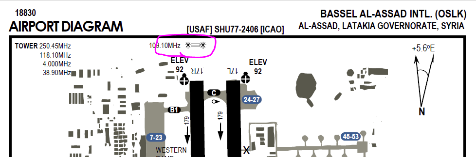
CombatWombat's Airfield Diagrams: Syrian Theatre
drPhibes replied to shu77's topic in DCS: Syria Map
This marking for LOC 17R is inconsistent with the actual location of the localizer (and where it would be marked in regular aeronautical nav charts). The localizer is ~170m south of the rwy 35L threshold, and the GP is approximately halfway between taxiway C and D in the chart.
-
CombatWombat's Airfield Diagrams: Syrian Theatre
drPhibes replied to shu77's topic in DCS: Syria Map
First of all, you have done a great job making these charts. Keep up the good work. Just one question regarding the "ILS location" symbols in your chart: is the placement intentional? All the ones I have checked (Bassel al-Assad, Beirut) have been in the wrong end of the runway. -
You should probaby have a look at the actual patch notes instead. There have been multiple updates to the F16 during november; both new features and bugfixes.
-
Thanks. I missed that one.
-
Yes, it is. Latakia = Khmeimim/Bassel al-Assad
-
Here are all the new airfields I could find in the map screenshot: Cyprus: Paphos RAF Akrotiri Larnaca Kingsfield Gecitkale Ercan Lakatamia Nicosia Pinarbashi Turkey: Gazipasa Gaziantep Syria: Deir-ez-Zor Tiyas Shayrat Sayqal
-
Bringing facts to an internet argument is borderline unsportsmanlike conduct :P
-
Just ignore him. Subs is on a reality-free diet, so don't expect any other proof than "god told me". Case in point (in addition to his post history on the forums), check out @ArkangelDaniel1 on twitter.