drPhibes
-
Posts
1189 -
Joined
-
Last visited
-
Days Won
2
Content Type
Profiles
Forums
Events
Everything posted by drPhibes
-
Correct removal of modules - Fixed with 2.9.20.15010 Update.
drPhibes replied to BrassEm's topic in Installation Problems
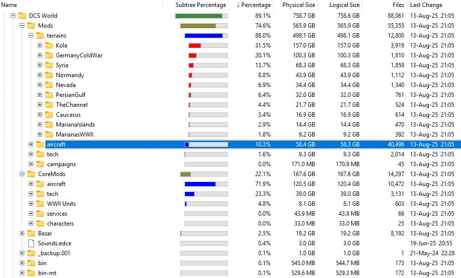
As western_JPN correctly points out, uninstalling aircratft doesn't free up much space. Modules are split into two main folders in DCS; Mods, where all the gameplay related parts (DLLs, cockpit models, LUAs etc.) of the modules you have installed are stored, and CoreMods, where all the 3d models and textures for every DCS aircraft, owned/installed or not, are stored. You can delete stuff from CoreMods, but it will be reinstalled every time you update DCS. As an example, my coremods/aircraft folder is twice the size of mods/aircraft, and I have every module installed except the MB-339, F4E, F-15E and the new FC:
-
Coordinates Cold War map wrong/off by *** metres/Nm ??
drPhibes replied to Mac D's topic in DCS: Cold War Germany
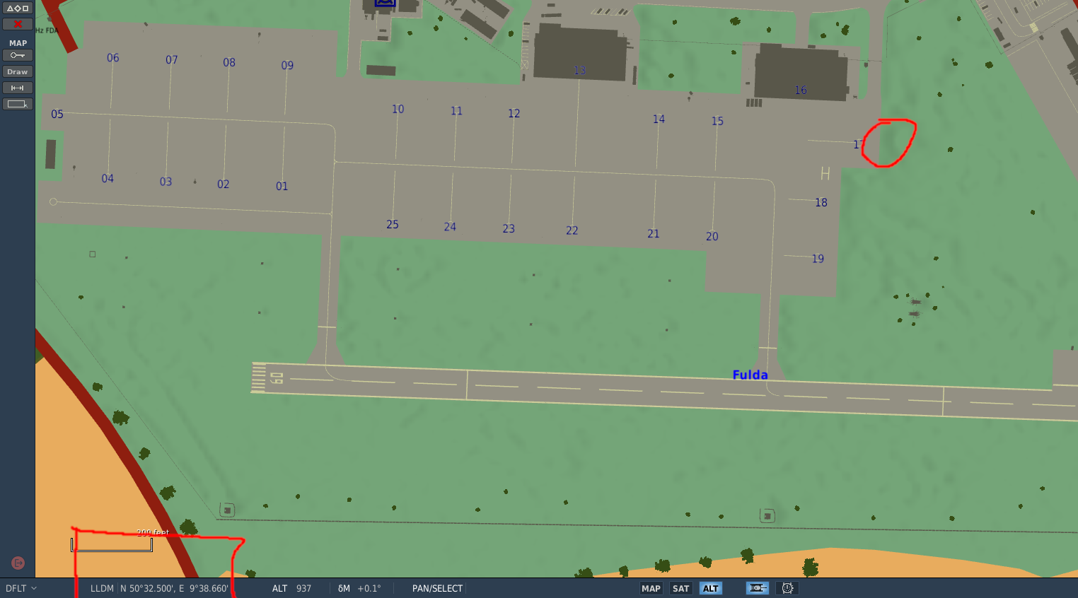
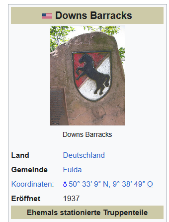
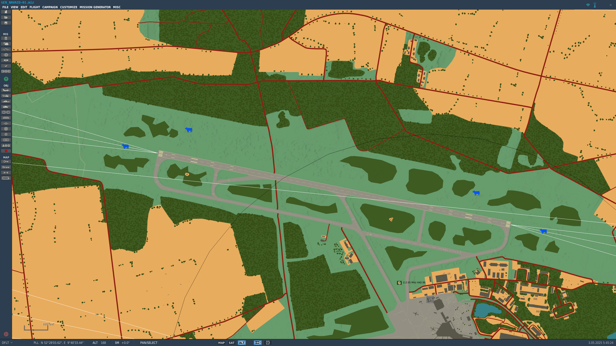
Both the airfield and the barracks are in their correct locations: null
-
Coordinates Cold War map wrong/off by *** metres/Nm ??
drPhibes replied to Mac D's topic in DCS: Cold War Germany
First of all, map coordinates are geographic, not magnetic, so magnetic declination has nothing to do with coordinates being wrong. The magnetic heading of a runway changes, but the coordinates don't. I did a comparison of some landmarks in the mission editor and Google Earth, and they are all pretty much spot on (within a fraction of an arcsecond in most cases): Spandau Citadel, Berlin: Google Earth: N 52°32'27.69" E 13°12'45.51" Mission editor: N 52°32'27.63" E 13°12'46.49" Bridge near Hamburg Planetarium: Google Earth: N 53°35'28.36" E 10°01'29.58" Mission editor: N 53°35'28.35" E 10°01'30.16" Mainspitze, west of Frankfurt: Google Earth: N 49°59'37.29" E 8°17'38.38" Mission editor: N 49°59'36.82" E 8°17'38.94" Neues Rathaus, Hannover: Google Earth: N 52°22'01.74" E 9°44'14.37" Mission editor: N 52°22'01.98" E 9°44'14.67" Fulda airfield: Google Earth: N 50°32'31.32" E 9°38'20.91" Mission editor: N 50°32'33.14" E 9°38'19.03" -
Livery creation without the model viewer is too cumbersome to be wort the effort. User created content is an essential part of the DCS experience for many players, so I hope ED just haven't gotten around to fixing this yet. There's nothing except time and development resources preventing ED from implementing model decryption in the model viewer.
-
If things haven't changed since the eighties, the correct frequencies should be: RWY 03: 109,3 MHz, ID: IHAE RWY 21: 111,3 MHz, ID: IHAW
-
ILS frequencies Incongruities in the Marianas map.
drPhibes replied to ac5's topic in Bugs and Problems
The airport has two parallel runways. 06L = 110.30 MHz, 06R = 110.9 MHz. -
The fields are the right size (approximately 100x65m), but the goals might be a bit oversized.
-
DME mode Y broken. Error identified with proposed fix.
drPhibes replied to drPhibes's topic in General Bugs
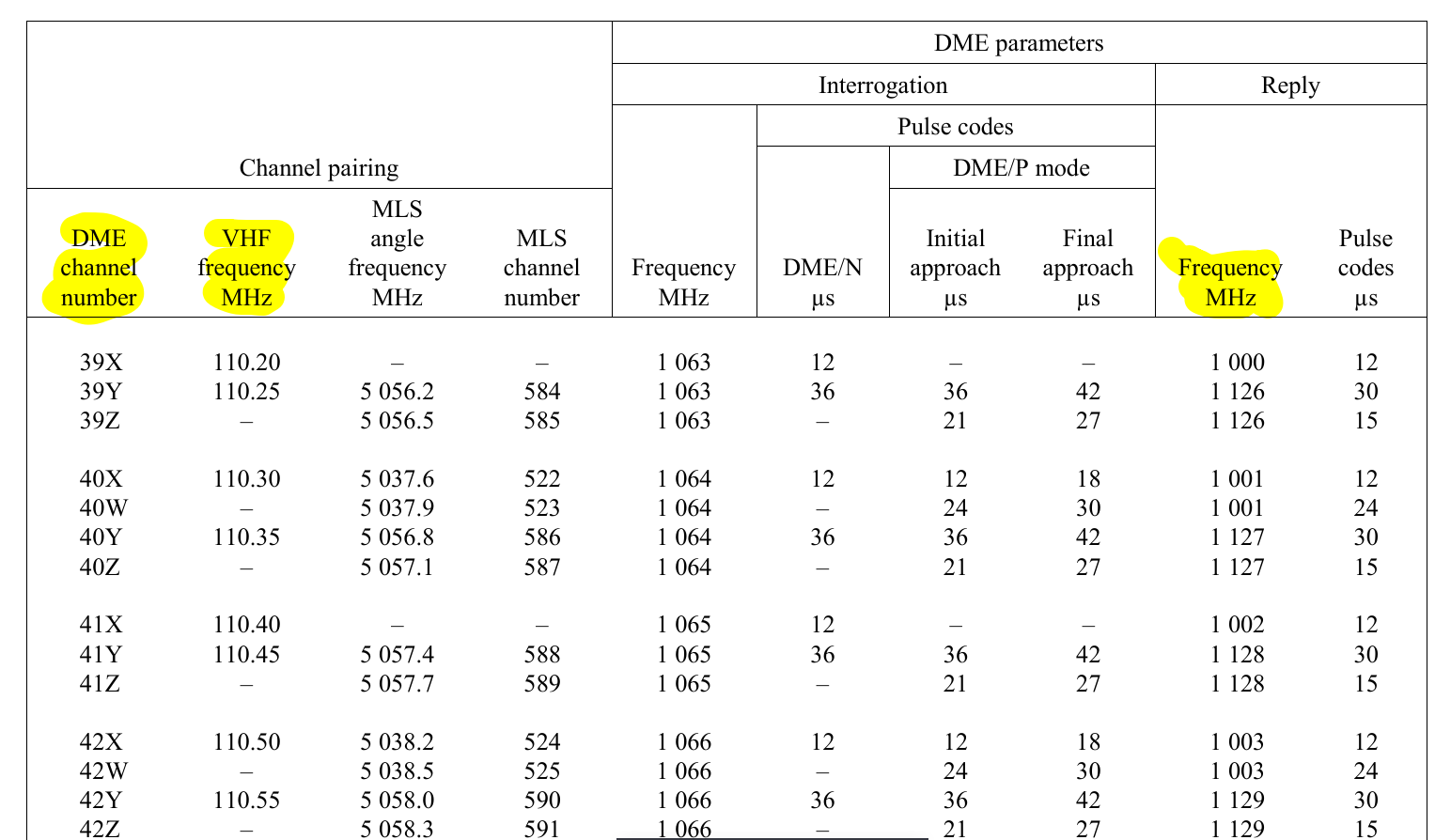
Some additional info on how to test this yourself (outside of dcs): Copy line 142 to 210 from BeaconTypes.lua to a new file, and add: VOR_freq = tonumber(arg[1]) print(VOR_freq/1000000, "\t",getPaired_DME_FrequencyBy_VOR_Frequency(VOR_freq)/1000000,"\t", getPaired_DME_ChannelBy_VOR_Frequency(VOR_freq)) to the end of the file. This prints the VHF frequency, DME reply frequency (both in MHz), the DME/TACAN channel and mode to the console. Then run the new lua file with your lua interpreter of choice, with the VHF frequency (in Hz) as an argument (e.g. "lua vhf-ch.lua 110200000"). Passing a list of all the VOR and LOC frequencies between 108 and 117.95 to the lua generates the following list. As you can see, the channel numbers for Y channels are 0.5 off, and the same goes for the Y channel DME reply frequencies (compare them to the attached screenshot from ICAO annex 10): VHF freq. DME reply freq. Ch. Mode 108.0 978.0 17.0 X 108.05 1104.5 17.5 Y 108.1 979.0 18.0 X 108.15 1105.5 18.5 Y 108.2 980.0 19.0 X 108.25 1106.5 19.5 Y 108.3 981.0 20.0 X 108.35 1107.5 20.5 Y 108.4 982.0 21.0 X 108.45 1108.5 21.5 Y 108.5 983.0 22.0 X 108.55 1109.5 22.5 Y 108.6 984.0 23.0 X 108.65 1110.5 23.5 Y 108.7 985.0 24.0 X 108.75 1111.5 24.5 Y 108.8 986.0 25.0 X 108.85 1112.5 25.5 Y 108.9 987.0 26.0 X 108.95 1113.5 26.5 Y 109.0 988.0 27.0 X 109.05 1114.5 27.5 Y 109.1 989.0 28.0 X 109.15 1115.5 28.5 Y 109.2 990.0 29.0 X 109.25 1116.5 29.5 Y 109.3 991.0 30.0 X 109.35 1117.5 30.5 Y 109.4 992.0 31.0 X 109.45 1118.5 31.5 Y 109.5 993.0 32.0 X 109.55 1119.5 32.5 Y 109.6 994.0 33.0 X 109.65 1120.5 33.5 Y 109.7 995.0 34.0 X 109.75 1121.5 34.5 Y 109.8 996.0 35.0 X 109.85 1122.5 35.5 Y 109.9 997.0 36.0 X 109.95 1123.5 36.5 Y 110.0 998.0 37.0 X 110.05 1124.5 37.5 Y 110.1 999.0 38.0 X 110.15 1125.5 38.5 Y 110.2 1000.0 39.0 X 110.25 1126.5 39.5 Y 110.3 1001.0 40.0 X 110.35 1127.5 40.5 Y 110.4 1002.0 41.0 X 110.45 1128.5 41.5 Y 110.5 1003.0 42.0 X 110.55 1129.5 42.5 Y 110.6 1004.0 43.0 X 110.65 1130.5 43.5 Y 110.7 1005.0 44.0 X 110.75 1131.5 44.5 Y 110.8 1006.0 45.0 X 110.85 1132.5 45.5 Y 110.9 1007.0 46.0 X 110.95 1133.5 46.5 Y 111.0 1008.0 47.0 X 111.05 1134.5 47.5 Y 111.1 1009.0 48.0 X 111.15 1135.5 48.5 Y 111.2 1010.0 49.0 X 111.25 1136.5 49.5 Y 111.3 1011.0 50.0 X 111.35 1137.5 50.5 Y 111.4 1012.0 51.0 X 111.45 1138.5 51.5 Y 111.5 1013.0 52.0 X 111.55 1139.5 52.5 Y 111.6 1014.0 53.0 X 111.65 1140.5 53.5 Y 111.7 1015.0 54.0 X 111.75 1141.5 54.5 Y 111.8 1016.0 55.0 X 111.85 1142.5 55.5 Y 111.9 1017.0 56.0 X 111.95 1143.5 56.5 Y 112.0 1018.0 57.0 X 112.05 1144.5 57.5 Y 112.1 1019.0 58.0 X 112.15 1145.5 58.5 Y 112.2 1020.0 59.0 X 112.25 1146.5 59.5 Y 112.3 1157.0 70.0 X 112.35 1031.5 70.5 Y 112.4 1158.0 71.0 X 112.45 1032.5 71.5 Y 112.5 1159.0 72.0 X 112.55 1033.5 72.5 Y 112.6 1160.0 73.0 X 112.65 1034.5 73.5 Y 112.7 1161.0 74.0 X 112.75 1035.5 74.5 Y 112.8 1162.0 75.0 X 112.85 1036.5 75.5 Y 112.9 1163.0 76.0 X 112.95 1037.5 76.5 Y 113.0 1164.0 77.0 X 113.05 1038.5 77.5 Y 113.1 1165.0 78.0 X 113.15 1039.5 78.5 Y 113.2 1166.0 79.0 X 113.25 1040.5 79.5 Y 113.3 1167.0 80.0 X 113.35 1041.5 80.5 Y 113.4 1168.0 81.0 X 113.45 1042.5 81.5 Y 113.5 1169.0 82.0 X 113.55 1043.5 82.5 Y 113.6 1170.0 83.0 X 113.65 1044.5 83.5 Y 113.7 1171.0 84.0 X 113.75 1045.5 84.5 Y 113.8 1172.0 85.0 X 113.85 1046.5 85.5 Y 113.9 1173.0 86.0 X 113.95 1047.5 86.5 Y 114.0 1174.0 87.0 X 114.05 1048.5 87.5 Y 114.1 1175.0 88.0 X 114.15 1049.5 88.5 Y 114.2 1176.0 89.0 X 114.25 1050.5 89.5 Y 114.3 1177.0 90.0 X 114.35 1051.5 90.5 Y 114.4 1178.0 91.0 X 114.45 1052.5 91.5 Y 114.5 1179.0 92.0 X 114.55 1053.5 92.5 Y 114.6 1180.0 93.0 X 114.65 1054.5 93.5 Y 114.7 1181.0 94.0 X 114.75 1055.5 94.5 Y 114.8 1182.0 95.0 X 114.85 1056.5 95.5 Y 114.9 1183.0 96.0 X 114.95 1057.5 96.5 Y 115.0 1184.0 97.0 X 115.05 1058.5 97.5 Y 115.1 1185.0 98.0 X 115.15 1059.5 98.5 Y 115.2 1186.0 99.0 X 115.25 1060.5 99.5 Y 115.3 1187.0 100.0 X 115.35 1061.5 100.5 Y 115.4 1188.0 101.0 X 115.45 1062.5 101.5 Y 115.5 1189.0 102.0 X 115.55 1063.5 102.5 Y 115.6 1190.0 103.0 X 115.65 1064.5 103.5 Y 115.7 1191.0 104.0 X 115.75 1065.5 104.5 Y 115.8 1192.0 105.0 X 115.85 1066.5 105.5 Y 115.9 1193.0 106.0 X 115.95 1067.5 106.5 Y 116.0 1194.0 107.0 X 116.05 1068.5 107.5 Y 116.1 1195.0 108.0 X 116.15 1069.5 108.5 Y 116.2 1196.0 109.0 X 116.25 1070.5 109.5 Y 116.3 1197.0 110.0 X 116.35 1071.5 110.5 Y 116.4 1198.0 111.0 X 116.45 1072.5 111.5 Y 116.5 1199.0 112.0 X 116.55 1073.5 112.5 Y 116.6 1200.0 113.0 X 116.65 1074.5 113.5 Y 116.7 1201.0 114.0 X 116.75 1075.5 114.5 Y 116.8 1202.0 115.0 X 116.85 1076.5 115.5 Y 116.9 1203.0 116.0 X 116.95 1077.5 116.5 Y 117.0 1204.0 117.0 X 117.05 1078.5 117.5 Y 117.1 1205.0 118.0 X 117.15 1079.5 118.5 Y 117.2 1206.0 119.0 X 117.25 1080.5 119.5 Y 117.3 1207.0 120.0 X 117.35 1081.5 120.5 Y 117.4 1208.0 121.0 X 117.45 1082.5 121.5 Y 117.5 1209.0 122.0 X 117.55 1083.5 122.5 Y 117.6 1210.0 123.0 X 117.65 1084.5 123.5 Y 117.7 1211.0 124.0 X 117.75 1085.5 124.5 Y 117.8 1212.0 125.0 X 117.85 1086.5 125.5 Y 117.9 1213.0 126.0 X 117.95 1087.5 126.5 Y Modifying the return value of the getPaired_DME_ChannelBy_VOR_Frequency(VOR_freq) function as described in the previous post generates the following results (which correspond with annex 10): VHF freq. DME reply freq. Ch. Mode 108.0 978.0 17.0 X 108.05 1104.0 17.0 Y 108.1 979.0 18.0 X 108.15 1105.0 18.0 Y 108.2 980.0 19.0 X 108.25 1106.0 19.0 Y 108.3 981.0 20.0 X 108.35 1107.0 20.0 Y 108.4 982.0 21.0 X 108.45 1108.0 21.0 Y 108.5 983.0 22.0 X 108.55 1109.0 22.0 Y 108.6 984.0 23.0 X 108.65 1110.0 23.0 Y 108.7 985.0 24.0 X 108.75 1111.0 24.0 Y 108.8 986.0 25.0 X 108.85 1112.0 25.0 Y 108.9 987.0 26.0 X 108.95 1113.0 26.0 Y 109.0 988.0 27.0 X 109.05 1114.0 27.0 Y 109.1 989.0 28.0 X 109.15 1115.0 28.0 Y 109.2 990.0 29.0 X 109.25 1116.0 29.0 Y 109.3 991.0 30.0 X 109.35 1117.0 30.0 Y 109.4 992.0 31.0 X 109.45 1118.0 31.0 Y 109.5 993.0 32.0 X 109.55 1119.0 32.0 Y 109.6 994.0 33.0 X 109.65 1120.0 33.0 Y 109.7 995.0 34.0 X 109.75 1121.0 34.0 Y 109.8 996.0 35.0 X 109.85 1122.0 35.0 Y 109.9 997.0 36.0 X 109.95 1123.0 36.0 Y 110.0 998.0 37.0 X 110.05 1124.0 37.0 Y 110.1 999.0 38.0 X 110.15 1125.0 38.0 Y 110.2 1000.0 39.0 X 110.25 1126.0 39.0 Y 110.3 1001.0 40.0 X 110.35 1127.0 40.0 Y 110.4 1002.0 41.0 X 110.45 1128.0 41.0 Y 110.5 1003.0 42.0 X 110.55 1129.0 42.0 Y 110.6 1004.0 43.0 X 110.65 1130.0 43.0 Y 110.7 1005.0 44.0 X 110.75 1131.0 44.0 Y 110.8 1006.0 45.0 X 110.85 1132.0 45.0 Y 110.9 1007.0 46.0 X 110.95 1133.0 46.0 Y 111.0 1008.0 47.0 X 111.05 1134.0 47.0 Y 111.1 1009.0 48.0 X 111.15 1135.0 48.0 Y 111.2 1010.0 49.0 X 111.25 1136.0 49.0 Y 111.3 1011.0 50.0 X 111.35 1137.0 50.0 Y 111.4 1012.0 51.0 X 111.45 1138.0 51.0 Y 111.5 1013.0 52.0 X 111.55 1139.0 52.0 Y 111.6 1014.0 53.0 X 111.65 1140.0 53.0 Y 111.7 1015.0 54.0 X 111.75 1141.0 54.0 Y 111.8 1016.0 55.0 X 111.85 1142.0 55.0 Y 111.9 1017.0 56.0 X 111.95 1143.0 56.0 Y 112.0 1018.0 57.0 X 112.05 1144.0 57.0 Y 112.1 1019.0 58.0 X 112.15 1145.0 58.0 Y 112.2 1020.0 59.0 X 112.25 1146.0 59.0 Y 112.3 1157.0 70.0 X 112.35 1031.0 70.0 Y 112.4 1158.0 71.0 X 112.45 1032.0 71.0 Y 112.5 1159.0 72.0 X 112.55 1033.0 72.0 Y 112.6 1160.0 73.0 X 112.65 1034.0 73.0 Y 112.7 1161.0 74.0 X 112.75 1035.0 74.0 Y 112.8 1162.0 75.0 X 112.85 1036.0 75.0 Y 112.9 1163.0 76.0 X 112.95 1037.0 76.0 Y 113.0 1164.0 77.0 X 113.05 1038.0 77.0 Y 113.1 1165.0 78.0 X 113.15 1039.0 78.0 Y 113.2 1166.0 79.0 X 113.25 1040.0 79.0 Y 113.3 1167.0 80.0 X 113.35 1041.0 80.0 Y 113.4 1168.0 81.0 X 113.45 1042.0 81.0 Y 113.5 1169.0 82.0 X 113.55 1043.0 82.0 Y 113.6 1170.0 83.0 X 113.65 1044.0 83.0 Y 113.7 1171.0 84.0 X 113.75 1045.0 84.0 Y 113.8 1172.0 85.0 X 113.85 1046.0 85.0 Y 113.9 1173.0 86.0 X 113.95 1047.0 86.0 Y 114.0 1174.0 87.0 X 114.05 1048.0 87.0 Y 114.1 1175.0 88.0 X 114.15 1049.0 88.0 Y 114.2 1176.0 89.0 X 114.25 1050.0 89.0 Y 114.3 1177.0 90.0 X 114.35 1051.0 90.0 Y 114.4 1178.0 91.0 X 114.45 1052.0 91.0 Y 114.5 1179.0 92.0 X 114.55 1053.0 92.0 Y 114.6 1180.0 93.0 X 114.65 1054.0 93.0 Y 114.7 1181.0 94.0 X 114.75 1055.0 94.0 Y 114.8 1182.0 95.0 X 114.85 1056.0 95.0 Y 114.9 1183.0 96.0 X 114.95 1057.0 96.0 Y 115.0 1184.0 97.0 X 115.05 1058.0 97.0 Y 115.1 1185.0 98.0 X 115.15 1059.0 98.0 Y 115.2 1186.0 99.0 X 115.25 1060.0 99.0 Y 115.3 1187.0 100.0 X 115.35 1061.0 100.0 Y 115.4 1188.0 101.0 X 115.45 1062.0 101.0 Y 115.5 1189.0 102.0 X 115.55 1063.0 102.0 Y 115.6 1190.0 103.0 X 115.65 1064.0 103.0 Y 115.7 1191.0 104.0 X 115.75 1065.0 104.0 Y 115.8 1192.0 105.0 X 115.85 1066.0 105.0 Y 115.9 1193.0 106.0 X 115.95 1067.0 106.0 Y 116.0 1194.0 107.0 X 116.05 1068.0 107.0 Y 116.1 1195.0 108.0 X 116.15 1069.0 108.0 Y 116.2 1196.0 109.0 X 116.25 1070.0 109.0 Y 116.3 1197.0 110.0 X 116.35 1071.0 110.0 Y 116.4 1198.0 111.0 X 116.45 1072.0 111.0 Y 116.5 1199.0 112.0 X 116.55 1073.0 112.0 Y 116.6 1200.0 113.0 X 116.65 1074.0 113.0 Y 116.7 1201.0 114.0 X 116.75 1075.0 114.0 Y 116.8 1202.0 115.0 X 116.85 1076.0 115.0 Y 116.9 1203.0 116.0 X 116.95 1077.0 116.0 Y 117.0 1204.0 117.0 X 117.05 1078.0 117.0 Y 117.1 1205.0 118.0 X 117.15 1079.0 118.0 Y 117.2 1206.0 119.0 X 117.25 1080.0 119.0 Y 117.3 1207.0 120.0 X 117.35 1081.0 120.0 Y 117.4 1208.0 121.0 X 117.45 1082.0 121.0 Y 117.5 1209.0 122.0 X 117.55 1083.0 122.0 Y 117.6 1210.0 123.0 X 117.65 1084.0 123.0 Y 117.7 1211.0 124.0 X 117.75 1085.0 124.0 Y 117.8 1212.0 125.0 X 117.85 1086.0 125.0 Y 117.9 1213.0 126.0 X 117.95 1087.0 126.0 Y
-
Orbx makes reporting bugs a bit harder...
drPhibes replied to virgo47's topic in Orbx Simulation Systems
One of the map devs (Specter) did comment on the VORDME bug post on the orbx site a few weeks ago, so they do seem to look at the bug reports (at least occationally). IMHO, having a bugs & problems section here instead would have been preferable, both with regards to ease of access and active user base. -
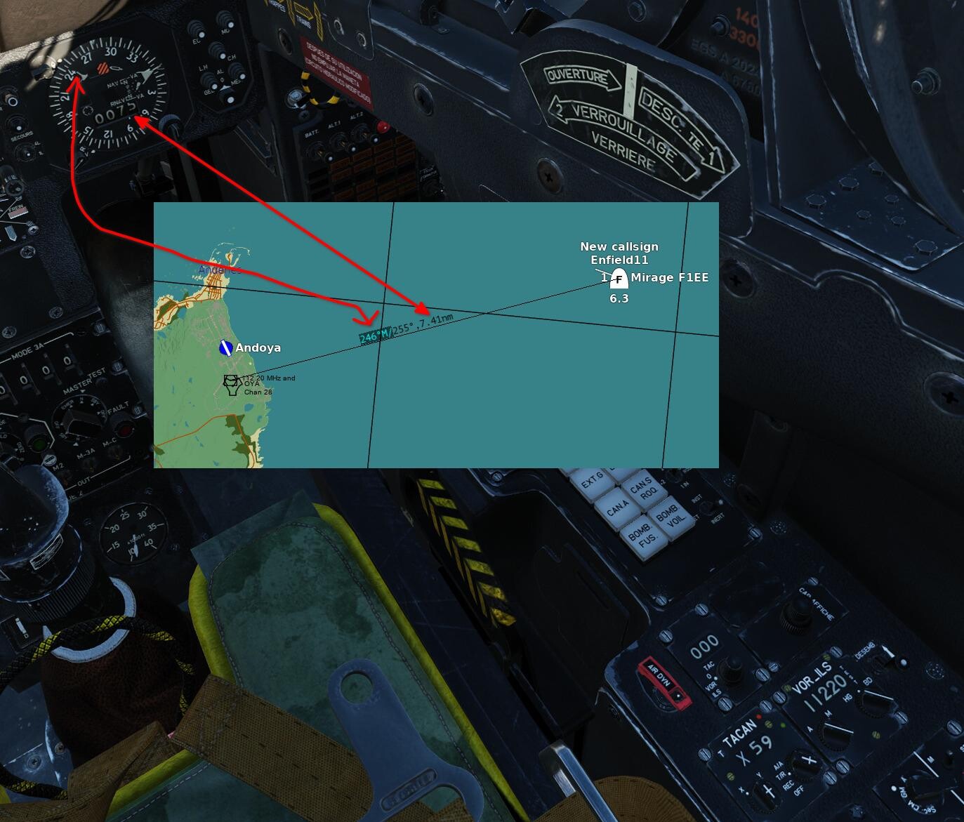
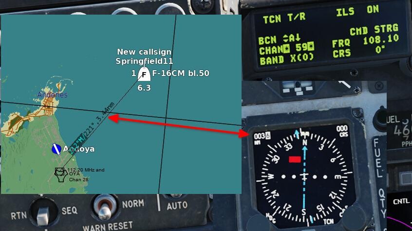
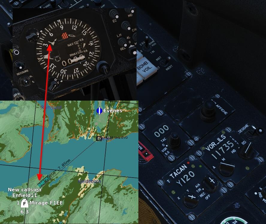
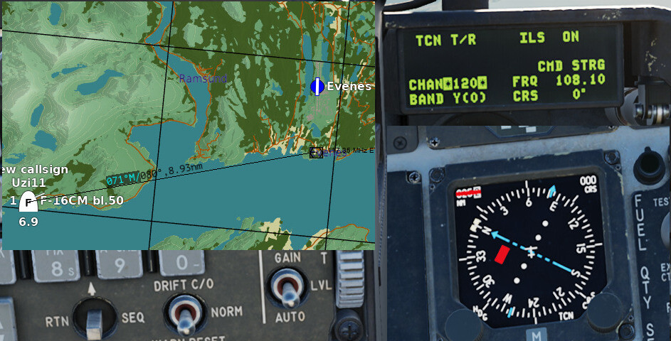
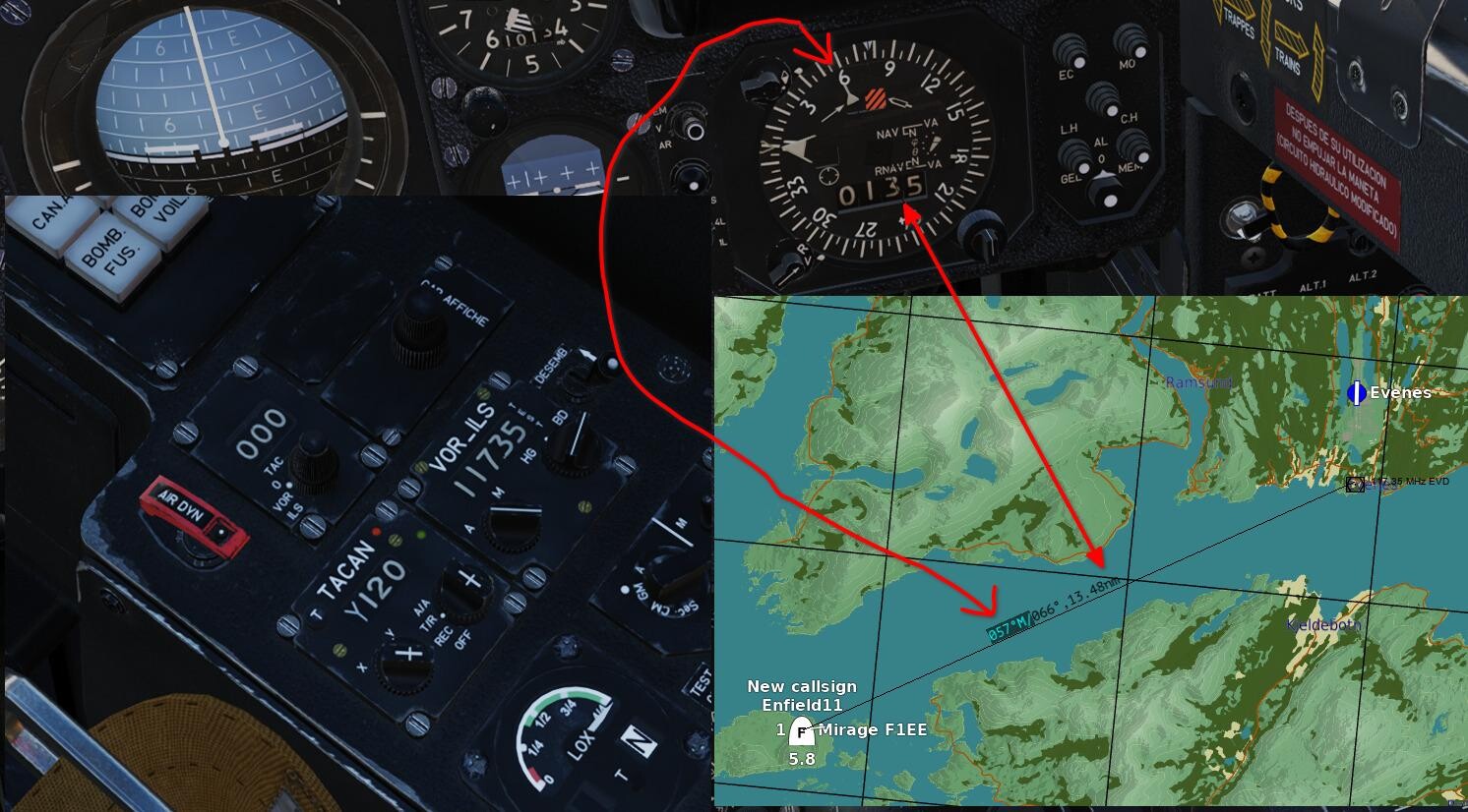
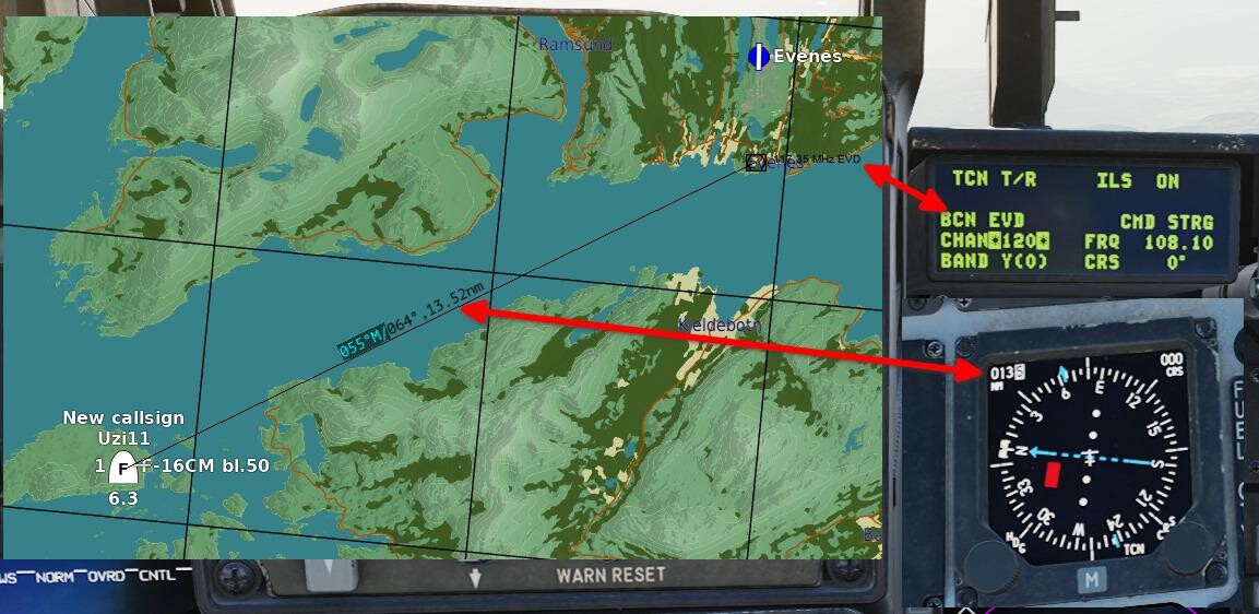
DME not working for Y channels has been an issue for years (always?), and after some digging in the LUAs, I think I have identified why, and how to fix it. First, in order to avoid confusion (which I have seen a bit of when VOR, DME and TACAN is discussed in the forums), here is some technical info (feel free to skip this paragraph if you already know this): VOR: an omni-directional beacon operating in the VHF band between 108 and 118 MHz, that radiates 360 radials you can tune your receiver to intercept. It also gives you the direct bearing to the beacon. The "R" in name VOR can be a bit of a misnomer, since a VOR does not provide range info, but it is due to the term "radio range" being used as a colloquial term for radio naviagation aids back in the day. DME: provides the slant range between the aircraft and the beacon. Each beacon operates on two frequencies in the 960-1215 MHz range; the interrogation frequency (transmitted by the aircraft) and the reply frequency (transmitted by the beacon), which are separated by 64 MHz. The frequencies are never set manually, instead they are assigned fixed channel numbers and a mode (X/Y) for ease of use. The X and Y modes refer to different spacing between the pulses used when determining the range, allowing twice as many DMEs to operate within the same frequency band. VOR/DME (or VOR+DME): A VOR co-located with a DME, giving you both bearing and range info. The VOR frequency and DME channel is paired according to ICAOs Annex 10, and every DME channel except 60-69 has a paired VHF frequency (either localizer or VOR). TACAN: This is where it gets a bit more complicated. A TACAN is a DME where a rotating, slightly directional, antenna generates a rotating radiation pattern that aircraft equipped with TACAN can use to determine the bearing to the beacon (like a VOR). All aircraft with TACAN can get the range to a DME and all aircraft with DME can get the range to a TACAN, but only the combination TACAN/TACAN will give you range and bearing. VORTAC: A VOR co-located with a TACAN. Works just like a VOR/DME for aircraft without TACAN, and like a TACAN for aircraft with TACAN. Now, on to the bugs: Test info: Testet on the following map: Kola, with Evenes VOR/DME (117.35 MHz / 120Y) and Andøya VOR/DME (112.20 MHz / 59X). No unofficial mods installed (before testing my proposed fix for the bugs, which requires changes to BeaconSites.lua and BeaconTypes.lua). The frequency / channel pairing is according to ICAO Annex 10. The channels are not included in the beacons.lua entries for the airports, but this parameter only displays the channel number in the ME/F10 map. The actual channel use is set up based on the paired VHF freq. Plane: Mirage F1EE (TACAN for range to DME, VOR for bearing to the VOR) and F16 (TACAN for range to DME (no VOR in the 16..)) F1EE: Evenes: bearing, but no range. Andøya: both bearing and range. F16: Evenes: no range. Andøya: range OK. See \DCS World\Scripts\World\Radio\BeaconTypes.lua and BeaconSites.lua for context (variables, function names etc). Issue 1: The function "getPaired_DME_ChannelBy_VOR_Frequency(VOR_freq)" in BeaconTypes.lua returns channel numbers correctly for X channels, but the function return value (return channelX2 / 2 + chStartVal, channelMode) does not take into account that the variable channelX2 is an odd number for Y channels, and thus returns a non-integer channel value for Y. Two examples: #1: Channel 19X: VOR_freq = 108200000 (108.2 MHz) freqToSubtract = 108000000 chStartVal = 17 channelX2 = (VOR_freq - freqToSubtract) / 50000 with numbers filled in: channelX2 = (108200000 - 108000000) / 50000 = 4 Determine X or Y: channelX2 % 2 = 0 => channelMode = X return channelX2 / 2 + chStartVal, channelMode with numbers filled in: 4 / 2 + 17 = 19, X --------- #2: Channel 19Y: VOR_freq = 108250000 (108.25 MHz) freqToSubtract = 108000000 chStartVal = 17 channelX2 = (VOR_freq - freqToSubtract) / 50000 with numbers filled in: channelX2 = (108250000 - 108000000) / 50000 = 5 Determine X or Y: channelX2 % 2 = 1 => channelMode = Y return channelX2 / 2 + chStartVal, channelMode with numbers filled in: 5 / 2 + 17 = 19.5, Y (Non-integer channel number!) The return from getPaired_DME_ChannelBy_VOR_Frequency is used by the function getTACANFrequency, which returns the wrong reply frequency if the channel number you pass to it isn't an integer. Changing the return to "return (channelX2 - channelX2 % 2) / 2 + chStartVal, channelMode" fixes this problem in the tests I have performed. This will give you the DME IDENT tone in the plane (tested in the Mirage F1EE), but no DME distance. The distance problem is described below: Issue 2: The DME part of the "[SystemName.VORDME]" section in BeaconSites.lua only contains the following signals: signals = SIGNAL_VOICE_AM + SIGNAL_DME + SIGNAL_TACAN_X. Adding "+ SIGNAL_TACAN_Y" is required for Y channel DME range (which is the same signal as TACAN range, hence the name). So, TL;DR: these two changes fix the non-working Y-channel DME (actual changes highlighted in green): BeaconSites.lua, change line 403 to: signals = SIGNAL_VOICE_AM + SIGNAL_DME + SIGNAL_TACAN_X + SIGNAL_TACAN_Y, BeaconTypes.lua, change line 199 to: return (channelX2 - channelX2 % 2) / 2 + chStartVal, channelMode Screenshots from my tests: Mode X DME working (+VORin the F1EE): Mode Y DME NOT working before fix (VOR works in the F1EE): Mode Y DME working after fix:
-
Hannover ILS runway 9L-27R not working
drPhibes replied to grim_reaper68's topic in Bugs and Problems
After some testing, I managed to get all the ILSes at Hannover working. For 09R/27L, All I had to do was to fix the direction of the GP (as described in the previous post), but just doing that didn't work for 09L/27R. After trying everything else (checking for frequency conflicts etc), I tried changing the beacon ID (the suffix after "airfleid19_", and that fixed it. If you delete all airfield19 entries (line 1640-1776) from beacons.lua and replace them with the following, you should have working ILS for all four runway ends. Note that this is not IC compatible, so remember to back up your original file. -- Fixed Hannover ILS -- 09L { display_name = _('Hannover'); beaconId = 'airfield19_99'; type = BEACON_TYPE_ILS_LOCALIZER; callsign = 'IHNW'; frequency = 108900000.000000; position = { -188436.453125, 51.180933, -730706.875000 }; direction = -78.514527; positionGeo = { latitude = 52.466823, longitude = 9.703153 }; sceneObjects = {'t:130102024'}; chartOffsetX = 2963.000000; }; { display_name = _('Hannover'); beaconId = 'airfield19_98'; type = BEACON_TYPE_ILS_GLIDESLOPE; callsign = 'IHNW'; frequency = 108900000.000000; position = { -187671.062500, 51.180936, -733377.500000 }; direction = -78.514527; positionGeo = { latitude = 52.469834, longitude = 9.662851 }; sceneObjects = {'t:48754130'}; }; -- 27R { display_name = _('Hannover'); beaconId = 'airfield19_97'; type = BEACON_TYPE_ILS_LOCALIZER; callsign = 'IHNE'; frequency = 108300000.000000; position = { -187795.875000, 51.180936, -733856.125000 }; direction = 101.497718; positionGeo = { latitude = 52.468062, longitude = 9.656230 }; sceneObjects = {'t:131006862'}; chartOffsetX = 2962.000000; }; { display_name = _('Hannover'); beaconId = 'airfield19_96'; type = BEACON_TYPE_ILS_GLIDESLOPE; callsign = 'IHNE'; frequency = 108300000.000000; position = { -188147.750000, 51.180936, -731212.125000 }; direction = 101.497718; positionGeo = { latitude = 52.468662, longitude = 9.695199 }; sceneObjects = {'t:48754131'}; }; -- 09R { display_name = _('Hannover'); beaconId = 'airfield19_7'; type = BEACON_TYPE_ILS_LOCALIZER; callsign = 'IHSW'; frequency = 109500000.000000; position = { -189994.000000, 51.180936, -730121.062500 }; direction = -78.514527; positionGeo = { latitude = 52.453909, longitude = 9.715167 }; sceneObjects = {'t:130102023'}; chartOffsetX = 2640.000000; }; { display_name = _('Hannover'); beaconId = 'airfield19_6'; type = BEACON_TYPE_ILS_GLIDESLOPE; callsign = 'IHSW'; frequency = 109500000.000000; position = { -189648.265625, 51.180936, -732407.375000 }; direction = -78.514527; positionGeo = { latitude = 52.453763, longitude = 9.681384 }; sceneObjects = {'t:47898667'}; }; --27L { display_name = _('Hannover'); beaconId = 'airfield19_2'; type = BEACON_TYPE_ILS_LOCALIZER; callsign = 'IHSE'; frequency = 108700000.000000; position = { -189416.812500, 51.180936, -732959.937500 }; direction = 101.497301; positionGeo = { latitude = 52.455030, longitude = 9.672881 }; sceneObjects = {'t:130102022'}; chartOffsetX = 2604.000000; }; { display_name = _('Hannover'); beaconId = 'airfield19_10'; type = BEACON_TYPE_ILS_GLIDESLOPE; callsign = 'PLG'; frequency = 108700000.000000; position = { -189997.359375, 51.180936, -730727.625000 }; direction = 101.497301; positionGeo = { latitude = 52.453033, longitude = 9.706422 }; sceneObjects = {'t:47900634'}; }; -- NDB, VOR etc { display_name = _(''); beaconId = 'airfield19_8'; type = BEACON_TYPE_AIRPORT_HOMER; callsign = 'HW'; frequency = 358000.000000; position = { -186564.000000, 44.580844, -741256.062500 }; direction = -72.689100; positionGeo = { latitude = 52.468492, longitude = 9.546607 }; sceneObjects = {'t:130999105'}; }; { display_name = _(''); beaconId = 'airfield19_11'; type = BEACON_TYPE_VOR_DME; callsign = 'HAD'; frequency = 113950000.000000; channel = 86; position = { -188825.078125, 51.180936, -731792.250000 }; direction = -90.824421; positionGeo = { latitude = 52.461880, longitude = 9.688376 }; sceneObjects = {'t:130102026'}; }; { display_name = _(''); beaconId = 'airfield19_0'; type = BEACON_TYPE_AIRPORT_HOMER; callsign = 'HA'; frequency = 320000.000000; position = { -189830.421875, 55.567503, -723867.187500 }; direction = -41.282514; positionGeo = { latitude = 52.464041, longitude = 9.805069 }; sceneObjects = {'t:130114993'}; }; { display_name = _(''); beaconId = 'airfield19_4'; type = BEACON_TYPE_AIRPORT_HOMER; callsign = 'HAE'; frequency = 332000.000000; position = { -187956.265625, 50.270390, -740012.312500 }; direction = -69.718198; positionGeo = { latitude = 52.457983, longitude = 9.567773 }; sceneObjects = {'t:130999104'}; }; 09L: 27R:
-
Phase 1, Wiesbaden Army airfield, radionav inaccuracies
drPhibes replied to Rongor's topic in Bugs and Problems
Guess who didn't see the first post in the thread It's not the first time I've been tricked by the browser automatically jumping to the first unread post. -
Hannover ILS runway 9L-27R not working
drPhibes replied to grim_reaper68's topic in Bugs and Problems
I placed some static objects (ICAO spec navaid cows) in the mission editor, opened the mission file in N++ and pasted the coordinates from beacons.lua. The positions are correct (GP 09L is a little off; it should be set back ~100m further from the threshold). The directions the beacons are pointing in seem to be the issue here. Both GPs are rotated by 90°: LOC 09L: -78,5° (correct) GP 09L: +10,6° LOC 27R: +101,5° (correct) GP 27R: -168,9° It should be fixable by changing the direction parameter for 'airfield19_5' to 101.497718 and 'airfield19_1' to -78.514527 in beacons.lua.
-
Phase 1, Wiesbaden Army airfield, radionav inaccuracies
drPhibes replied to Rongor's topic in Bugs and Problems
At some point in time the TACAN was moved from the position shown in the 1966 charts tot he current position (just south of the threshold for RWY 07), which is probaby why the ident and frequency was changed. -
Not directly. You have to open the .miz file with 7zip (or similar software; it's just a zip file), and edit the text file named "mission" in the zip.
-
Unable to land helicopter on hospital west of peenemunde
drPhibes replied to Bartek16194's topic in Bugs and Problems
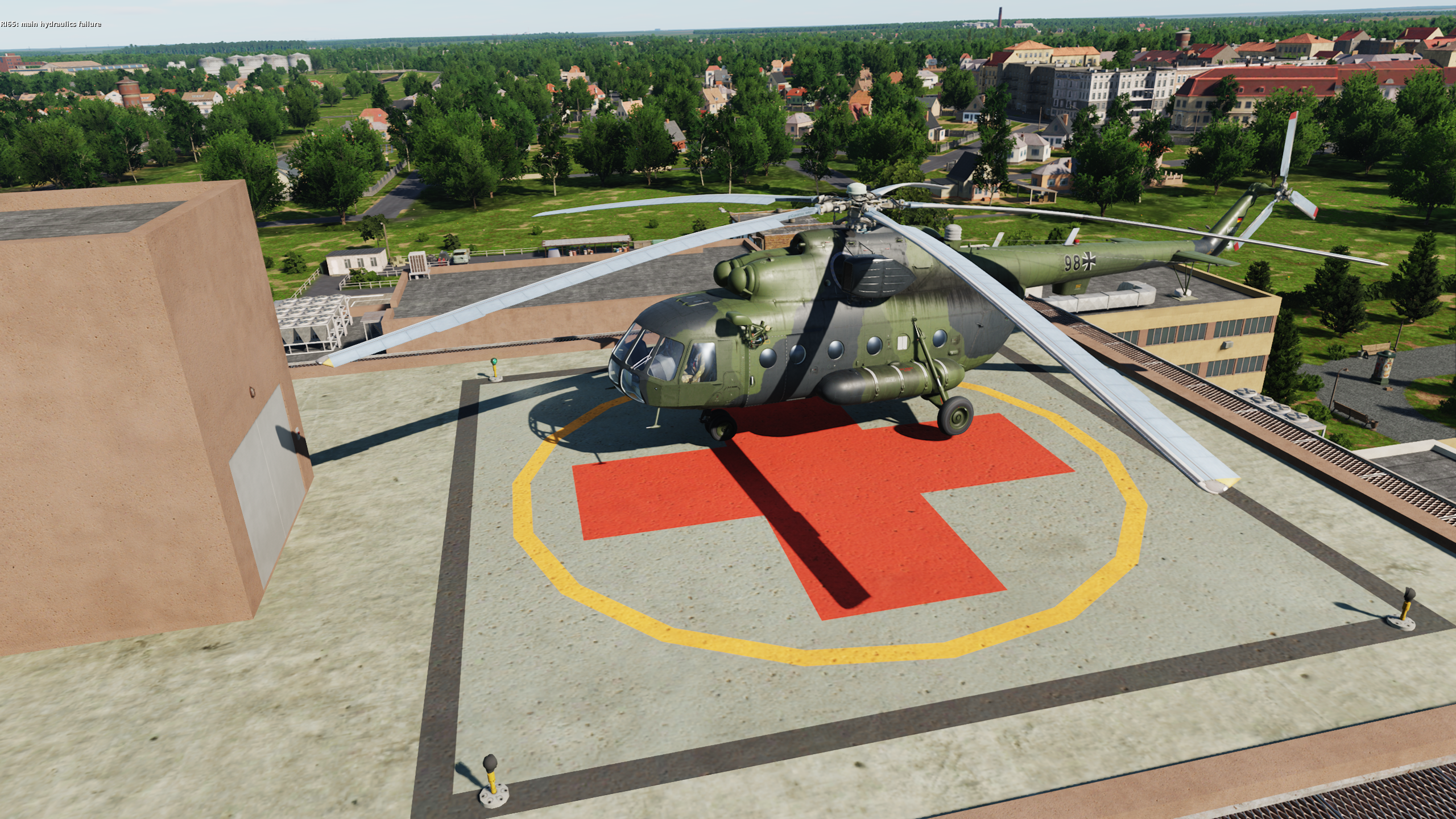
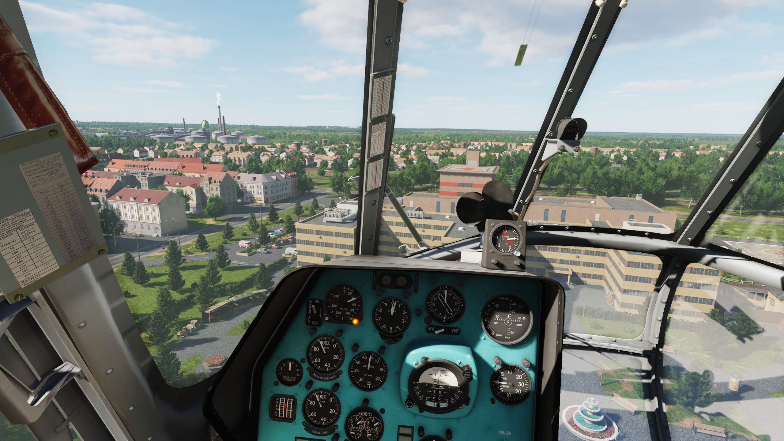
1) As others pointed out, that isn't the helipad. 2) Landing on the roof works just fine. Watch your clearence. You clipped the top of the elevator shaft with your main rotor.
-
Cottbus is already on Ugra's list. See the FAQ.
-
The comment is from before the thread was moved from the Cold war Germany subforum.
-
The spelling errors are intentional, in order to avoid any trademark issues.
-
Just watch out for those annoying Ferrari 328 and Ford Escort drivers.
-
It might not be, but it's pretty obvious why someone would jump to that conclusion. You really need to start seeing your own limitations, instead of constantly ignoring every single piece of advice (from people who know what they are doing, and are trying to help you!), and then blaming everyone else when you aren't able to do something. All of your "bug" reports seem to boil down to a) that you haven't understood how a thing is supposed to work, and b) you refusing to listen when someone tells you that you are doing x, y or z wrong.
-
I wouldn't touch wubuntu with a barge pole. It's just Kubuntu with Wine, a Windows-like KDE theme, some stolen Microsoft assets and added spyware. Trademark and copyright violations aside, the people behind it seem quite sketchy. TL;DR: you're better off with a regular linux distro + Wine if you want to play DCS (it works reasonably well according to the hoggit nerds: https://wiki.hoggitworld.com/view/DCS_on_linux).
-
You are right about the TACAN being missing, but you are mixing up the channel with the DME located right next to it. Andøya TACAN (ID: OYA) = 28X. Source: https://ais.avinor.no/no/AIP/View/135/2024-11-28-AIRAC/html/eAIP/EN-ENR-4.1-no-NO.html#ENR-4.1
-
30MB/s here, so it's more likely an ISP issue than an ED issue.
-
Who said anything about the command line? Those changes are made in config files that you can edit with any text editor.