doodenkoff
-
Posts
435 -
Joined
-
Last visited
Content Type
Profiles
Forums
Events
Everything posted by doodenkoff
-
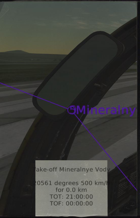
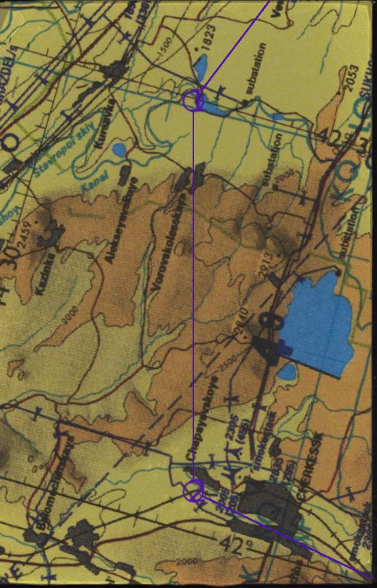
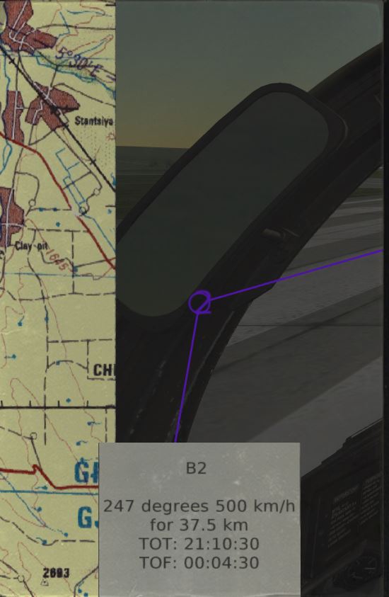
The first initial kneeboard images in the Viggen, that are supposed to be different scale maps of the waypoints, are bizarrely formatted. I'm wondering if there is anything I can do to correct it. The text notes--waypoint data, airfield info, markers, etc--are fine, it's just the first initial dynamic maps. I've attached some samples.

-
Please can you tell me where I can find the first detent ?
doodenkoff replied to Skulleader's topic in DCS: AJS37 Viggen
Thanks. I haven't been clear on putting the system back to T0. It seemed like it would revert back to that state, but that didn't feel right. -
Please can you tell me where I can find the first detent ?
doodenkoff replied to Skulleader's topic in DCS: AJS37 Viggen
So the process of a manual "fix" then would be to press and release your T1 button, then press and release your "TV" button when over your marker, then press "T0" to put it back to default? -
Good man....keep up the good work.
-
It's a booger to find. A hint, it's right at the confluence of three valleys. Use your attitude hold (ALT + 2 in the Su-25T) to start an orbit in the area, then use -ag to start triangulating.
-
Phobon's fix should work for an X52 two-stage trigger, shouldn't it?
-
I guess there's no doubt that mirknir is a software person.
-
Operation "Blue Flag" - 24/7 PvP Campaign - ROUND 9
doodenkoff replied to gregzagk's topic in Multiplayer
That's kinda' strange. -
Holy smokes....are you on Mars?
-
Practice trim and power settings to get to a point where you can release the stick and be confident the plane won't go bonkers. Some, like the Su-25T are stupid simple to put in straight and level autopilot. Learn how your autopilot works.
-
At Krymsk.... HAL, please open the pod bay doors... These two guys.... ...might still be there.....
-
:doh: Overwrite an existing skin, like "Hellenic", with a new custom skin....... :doh:
-
Can we have this skin please? It's too cool. Just let me know, I'll point you at the download.
-
That may explain why I've been so unusually elegant in my Huey lately.
-
Imma load up a Huey and go on a shootin' spree tonight.
-
I don't have the menu right in front of me.....but requests to make changes on Open Conflict cost $20 USD...or somewhere around that much. It's payable to Mirknir at the PayPal link in his signature.
-
Lost the pilot, but successfully escaped the Shilka shooting at me, and got the rescue completed. Which was trippy, 'cause I can barely fly a Huey from the copilot seat, much less land one.
-
Makes landing into the wind fun....
-
The worse is going for the rescue, finally finding the smoke, and discovering the pilot was downed by a Shilka....that's still there.
-
That's true...but maybe 5 - 6 m/second is a more appropriate level for practice. 11 meters per second is probably a shock for a lot of people. It certainly is for me...I get a kick out of flying a Huey sideways though.
-
How about getting the ground crew to disconnect ground power? I can't get a disconnect....when I leave from Krasnodar it's all, "hey, what are you doing?" I try repeated attempts at the FARP and at Krasnodar and it will not disconnect.
-
You're an experienced pilot. That is not a fair comment.
-
Didn't make any difference. I watched the voltmeter, it jumps to about 11 v when I first hit the starter button and almost immediately slides down to about 5 - 6 v.
-
I'll have you know, I gave myself a, "you dolt" head slap when I read that. Thanks for the nudge.
-
That video was recorded with Skullz turned off. Dumb question time....how do I set the throttle at 40%? I've always done it by the manual, "page up" to fully open the throttle, then "page down" to set it to the start position.