MikeMikeJuliet
-
Posts
1223 -
Joined
-
Last visited
-
Days Won
2
Content Type
Profiles
Forums
Events
Everything posted by MikeMikeJuliet
-

Exemption of AMPCD maps from Integrity Check
MikeMikeJuliet replied to MikeMikeJuliet's topic in Wish List
The maps are customised to the needs of the flying unit. There are several different styles of aeronautical charts, and many militaries actually have completely custom charts. It's not a case of the military putting the civilian chart in there - mission support personnell can build a map from the ground up basically if need be. Although the Finnish Airforce uses the newer displays, there are a few videos using a black moving map with relevant training area borders in purple/magenta. Those are definitely not civilian aeronautical charts. It would be critical to have a map on a mission IRL where you would have to constantly discern which areas are "real" and which areas are not during the mission just because nobody bothered to install relevant maps. That would increase pilot workload needlessly. The reason most videos on the internet show aeronautical charts, is because most videos are filmed in areas where said airspace is still valid. And I'm not talking about weither or not a single area is active currently, rather weither the whole airspace structure is valid or not. Sure, one can fly with any aeronautical chart, but purpose built ones would for sure be preferred. The aircraft itself does not care what color and what symbology is baked onto the map as long as it is not to do with hardware limitations (like display color palette, which is not the case with the DCS F/A-18C AMPCD). It does not care if the map is "official" or custom made. But the pilot does. Another way to look at this is: if an airspace was completely reshaped for wartime operations, the civilian aeronautical charts wouldn't be valid, because at that time the airspace does not exist anymore. Similar to when a country rebuilds it's airspace structure - you can't go flying with the old maps. The files are, actually now that I think about it, under the map installation folder, under rastermaps. So technically I should have posted this on the general wishlist as it concerns all the modules that use the maps. It's not under savedgames... if it were then modding them would not break IC. Sorry, the reply wound up a bit long. Point is this wish is not made on a whim. Participation to the discussion if very much appreciated. Allows me to make the point clearer. Regards, MikeMikeJuliet- 11 replies
-
- 1
-

-
- moving map
- ampcd
- (and 3 more)
-
Exemption of AMPCD maps from Integrity Check
MikeMikeJuliet replied to MikeMikeJuliet's topic in Wish List
The poor readability comes in part from the fact that the map beneath the green symbology is made with colors that do not make the symbology pop. That is in fact not "correct as is" but a function of what kind of map is loaded onto the aircraft. There is no reason the map under the symbology would have to be a color that hides the symbology given that the AMPCD is a full color screen. On your second point yes, I would love to have the ability to "bake" drawings from the ME that would then show on the map. But there is an issue there: the current maps (example: Caucasus) already has stuff baked into the map itself that you cannot remove without modifying the map beneath. In the end both would need to be implemented. But if only one was, then the ability to alter the maps would allow for the same functionality that your suggestion would, with the added benefit of customising everything else regarding the moving maps as well. It would be more cumbersome for sure. Besides ED removing IC from the maps would be a really easy step for them versus building a system where they alter the maps on runtime based on ME drawings. Regards, MikeMikeJuliet- 11 replies
-
- 1
-

-
- moving map
- ampcd
- (and 3 more)
-
When will we see a moving map for the AMPCD for all the terrains?
MikeMikeJuliet replied to plott1964's topic in Wish List
No quite the same issue, but I've got a thread about releasing the maps from under IC so that players could customize their own maps depending on their needs. Say, you fly on a server with a custom airspace - the maps we have now don't really serve you since there are a bunch of real life airspace boundaries drawn there etc. If you want to support that, the thread is here: Meawhile I support the idea for having maps for all playable areas as well as multiple zoom levels. What's the point of having the system if you can only have one (not so helpful) map that is at a zoom level of 5NM for example, when you mostly would use something else... The feature on the aircraft (and not only the hornet, but all the aircraft with moving maps) is severely restricted and its potential left unused at its current state. Regards, MikeMikeJuliet -
Exemption of AMPCD maps from Integrity Check
MikeMikeJuliet replied to MikeMikeJuliet's topic in Wish List
I'm raising the topic back from it's slumber. I realise this is the Hornet's whislist, but the feature ought to work the same for all modules. I hope this get's a bit more attention. I'm not sure if people realise just how powerful having custom maps onboard the aircraft really is. The current situation is very limiting - so much so that I for one turn the map off completely (mostly due to it's brightness making the HSI near unreadable, but also because the map rarely serves the flight). Regards, MikeMikeJuliet- 11 replies
-
- 4
-
-
- moving map
- ampcd
- (and 3 more)
-
I've added a new idea into the mix: request the ability to snap route-tool points to drawings (specifically waypoints as per suggestion no.6). This would make setting up routes with some or all common points much simpler if the mission designer has draw a set of waypoints around the map (I sure have, as one can see in the screenshots), even when a common route-tool preset is not shared. Especially handy when you would need one or two common points without having to resort to editing an existing, but otherwise unusable set of waypoints for your flight. Regards, MikeMikeJuliet
-
Mmm, yes, that would help manage the drawings even further in the editor. Good idea!
-
Great to see modders adding some very welcome (and might I even say, crucially needed) cold war aircraft to the game! Even if "only" FC-level of complexity, the fact that this can be flown at all closes the gap we have right now between the early cold war and modern era jets on the redfor side. Great work so far!
-
The absolute text size is a good idea! It actually crossed my mind writing the list, but there were so many items there and I was running out of time that I forgot to add it. It's edited in to the OP now. Thanks!
-
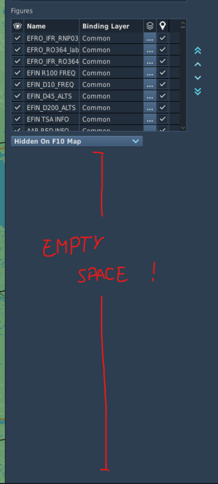
Hello! The draw tool needs refinement. Having used it quite extensively I have a few important changes/additions/fixes that, I argue, are essential to make the draw tool user friendly and thus faster and more efficient to use. There are several topics regarding different wishes and discussions regarding the draw tool, but none that quite list everything needed in my opinion. I do second every one of the suggestions I found with a quick search. Links to the respective threads at the end of this post. Absolute priority number one!: Add the ability to lock drawings As a set of drawings becomes increasingly comples and large drawings overlap, it is extremely easy to accidentally pick the wrong drawing, then move it only to realise a bit later that you just messed up a drawing, say, a circle, that you now have to eyeball to be positioned back to where it was! When a drawing is done, the user generally does not want to move it further. Having all the drawings be there waiting like traps to be selected accidentally has lost me hours of work trying to fiddle with the tool. Expansion of the draw item -list The draw item list occupies only a small set amount of screen space. With dozens of drawings having the list window as small as it currently is is a total waste of screen real-estate and makes the tool more cumbersome to use. Either have the tool resize it self according to available space, or at least give users the ability to resize the list window themselves Allow arranging/filtering of drawings by name Again, as the list grows longer different items are really hard to keep track of unless one constantly arranges the items manually. This again wastes serious amounts of time that could otherwise be spent actually using the tool! I understand that the items in the draw list are in drawing order, so probably give the items a visible draw order index (per layer obviously), and then give the user the ability to order the drawings by name. Layers/categories can stay separate - those are easy to handle. Fix the item movement in the list Re-ordering the items in the list currently jumps the user to the beginning of the list! With dozens of drawings that one may want or need to arrange this is a horrible UX bug. Please fix! Allow the user to change the anchor-point of text labels Often times a drawing needs to be anchored from other points than the top left corner. Plenty of texts would need to be anchored from either the middle of the text-box, or from the mid-point of either the top or the bottom edge of the text rectangle. I would recommend all the corners, edge-midpoints and the whole shape mid-point to be added as possible anchor points to allow for most flexibility An improper anchor point makes drawings really messy and hard to look at especially when zoomed a lot from the intended viewing zoom-level, making large draw sets appear really cluttered Add air navigation symbology Please add default symbology (Jeppesen or otherwise) for NAVFIXes, VORs, TACANs, DMEs, and such shapes as default triangles etc. At the current state the user has to create these by-hand which is cumbersome and unnecessary. Allow drawings to be set invisible by zoom-factor A lot of the time on congested drawings some details might want to be omitted when looking at a large scenario from smaller zoom-levels (e.g. from far away). An per-drawing adjustable invisibility range (both ends!) would really be useful for decluttering the drawing and allowing for additional details to be drawin, but only as the player zooms in enough (or out for that matter) Add dedicated arc-drawing tool (with and without lines to origin) Arcs and sectors are needed to draw more complex shapes without resorting to freehand drawings constantly. A simple circle does not cover all the cases. There are, for example, a lot of airspaces that are built with several arcs IRL. Building similar airspaces with drawings currently is a time consuming process of using circles to help draw freehand - these could be bypassed by simply allowing for an arc-draw. Add racetrack-shape (see "racetrack polygons in Draw function" below) I second this wish. Being able to draw racetracks would be really useful Add editing, adding and removing of shape points (see "Draw Tool - point mode" post below) I second this! So many "oh whoops, wrong button!" -mistakes costing me a lot of time after making a complex shape just because I cannot edit the shapes afterwards. Definately a feature that is needed! EDIT: In fact the existing points can be moved, but more points cannot be added or removed once the shape is completed Allow the user to change the amount of vertices on a circle On the same lines as point no.10. As the circles become larger the amount of vertices is really apparent and may not be sufficient in all cases. Please add a value to change the amount of vertices on a selected circle. EDIT: Suggestion number 12: Allow the user to set text size that is either tied to the screen size/zoom (the way it is now), but also set an absolute size, so that the text size stays the same compared to the background map and other drawings regardless of zoom. There are plenty of instances where you do not want the text to change along with zoom. EDIT: Added some screenshots to illustrate the points above EDIT: Added a commenter's suggestion to the list EDIT: Suggestion number 13: ability to snap route-tool waypoints to existing drawings. To make sure the route would not snap to anything-and-everything a toggle "route too snapping" for a given drawing might be wise to add, as well as to have the snapping be togglable (much like how in vector-drawing software you can toggle snapping on and off). This way you could keep, say, waypoint symbols (see suggestion number 6) with option "route tool snapping", and as you actually do your route, you could either allow snapping as a user, or toggle it off for completely free placement of route points. The possible points to snap to could be waypoints, text-field-anchor points (I would imagine these would most often just be left OFF by default) and any polygon/line vertex (i.e any corner point), on a per-drawing basis. This would help out a lot on larger missions where the mission maker wants to give players a lot of possible waypoint references to be used, but not all of them are needed for any one flight. It would also ensure that a single waypoint shared between two different flights would actually be the same, instead of being approximately the same. For additional functionality, the snapped route point could actually inherit its name from the waypoint. Here it would be best give the waypoint a third text field "route tool name", because I bet most ME users would like to name their points akin to "blue_wpts_ABCDE" instead of just ABCDE, that you would then want to show as the route name in the route tool. Previously suggested improvements: Regards, MikeMikeJuliet Image 1: text as intended by the author Image 2: text and image gets cluttered because text scales with zoom Image 3: a cluttered image when zoomed out - this could be alleviated either by being able to set some of the drawings invisible as you zoom out and/or by setting an absolute text size instead of zoom scaling text Image 3: Unused space around the drawings list. This particular list is probably some 150 drawings long and going through it to find a specific drawing (especially if it isn't in order) wastes time completely unnecessarily.

-
Feature request: Kollsman window in barometric altimeter
MikeMikeJuliet replied to TOViper's topic in F-15C for DCS World
I second this. Sure, you can set the pressure setting to anything on the ground if you have the reference altitude (so either zero it if setting QFE, or set it to the aerodrome altitude if using QNH), but there is no way to reliably alter the pressure airborne since you have no reference to set it with. For those who don't know: as the air pressure changes either with time or you moving from A to B, the altimeter has to be reset in the air at the very least for landing. DCS doesn't have a proper simulation of airmasses yet (the old dynamic weather front system is horrible to use), but as the dynamic weather is introduced at some point this *WILL* become a problem for the F-15C pilots. Not a matter of if, but when. Altimeter setting is one of the handful of critical things any airman must handle. ED please get this fixed -
Any news on this? This has been an issue for HUDs ever since heatblur has been a feature. I for one would like to have an explanation why it is so difficult to fix. Seems to me (though I'm no expert) that is should/ought to be possible to simply render the HUD afterthe heatblur effects, no? Regards, MikeMikeJuliet
-
Exemption of AMPCD maps from Integrity Check
MikeMikeJuliet replied to MikeMikeJuliet's topic in Wish List
Well, that would effectively do the same thing. I don't mind which way it is done, as long as it would be possible to customize the maps. Install-folder or savedgames, all the same for me as long as the functionality is there. -
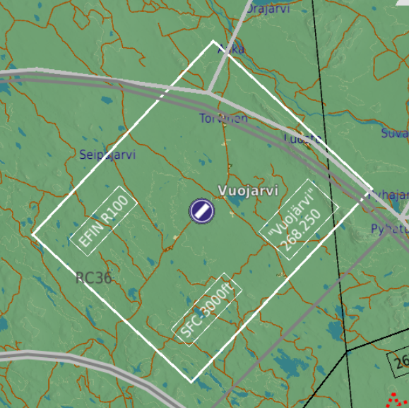
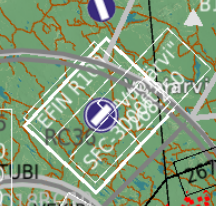
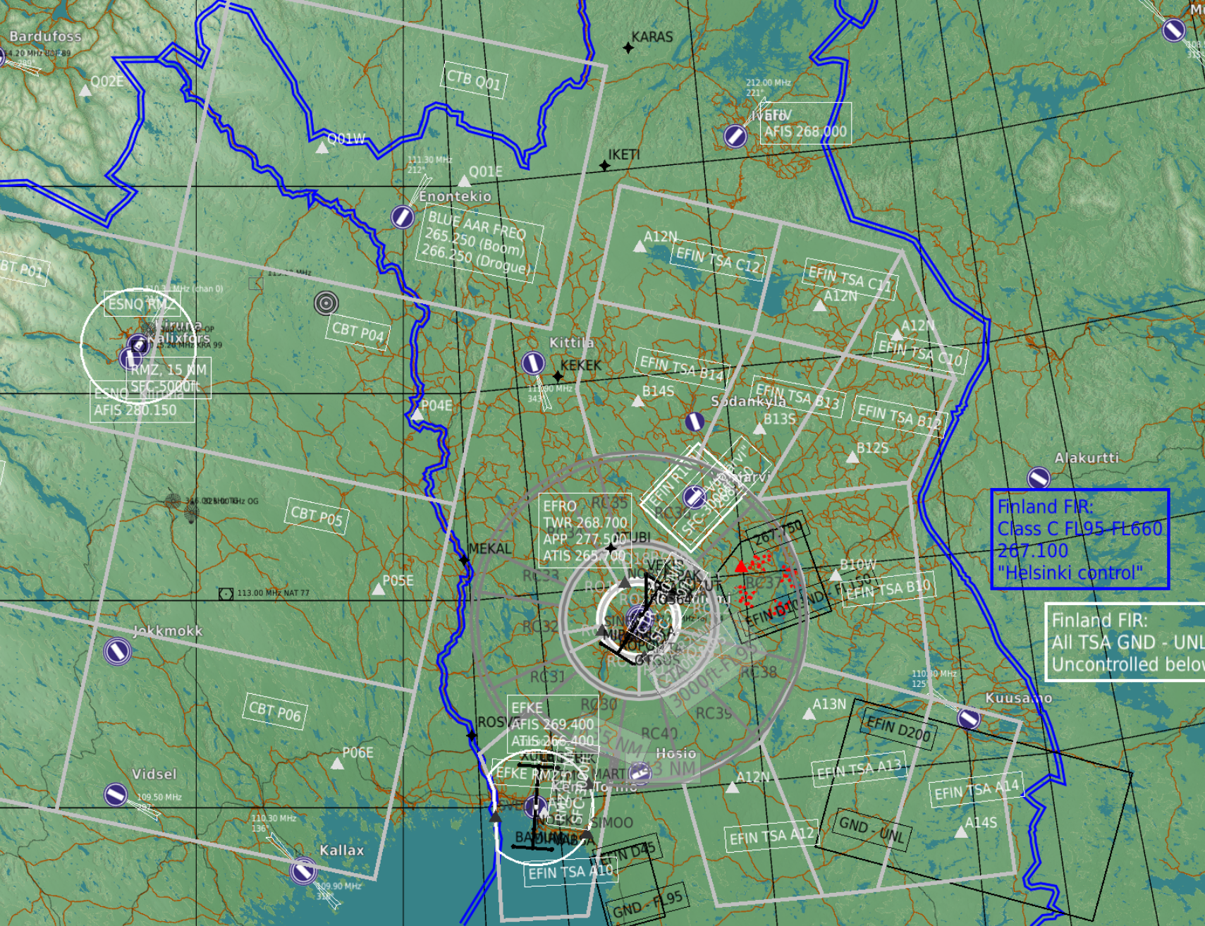
Hello! I have a request considering the maps in the module's installation folder that are used on the HSI-page in the AMPCD that these could be exempted from IC. The reasoning is twofold: first off, all the maps can be customized in the actual aircraft by Mission Support, and so we should be able to do that too. I am not arguing for a tool to make the maps, just that we would be able to alter the files as we need to. Secondly: the current map with the current gain and the green symbology is really difficult to read at a glance. Even at lowest gain the symbols tend to not be bright enough and the map dark enough to read the display as easily as we should be able to. The benefit for adding an exception in the IC is that we could simply go throught the maps and adjust their brightness to a darker tone (I've tried this and it works really well), or the players could even modify the maps to the specific needs of a specific mission, drawing custom areas and borders etc in the maps, instead having to rely on a specific map that in many cases doesn't suit your needs. I do not see how having the maps under IC provides any protection against malicious player behaviour. IRL you can have what ever kind of map under your HSI that you need. This would greatly enhance the usability of the moving map in the F/A-18 Thank you for considering! Regards, MikeMikeJuliet
- 11 replies
-
- 12
-
-
-
- moving map
- ampcd
- (and 3 more)
-
Here's another set, this time active pause is used. Caucasus, Su-25 instant action. Cursor is pressed, leaving it on the aircraft position. First one is again north up: And second is track-up: As you can see here, both coordinates show the same point in track-up. The difference is also not as noticeable because both coordinates are pretty close to each other. The position of the cursor has not changed and neither has the aircraft's pos, so it's not that. Regards, MikeMikeJuliet To the last post, here's another thing: Exactly same position, but I move my coursor to the left in Track-up (to the north) which makes the latitude decrease in stead of increase. Longitude has changed logicalle (the heading of the aircraft is about 098, so moving the cursor directly left does not equal exactly north which would keep the latitude unchanged) I hope these help to get to the bottom of this Regards, MikeMikeJuliet
-
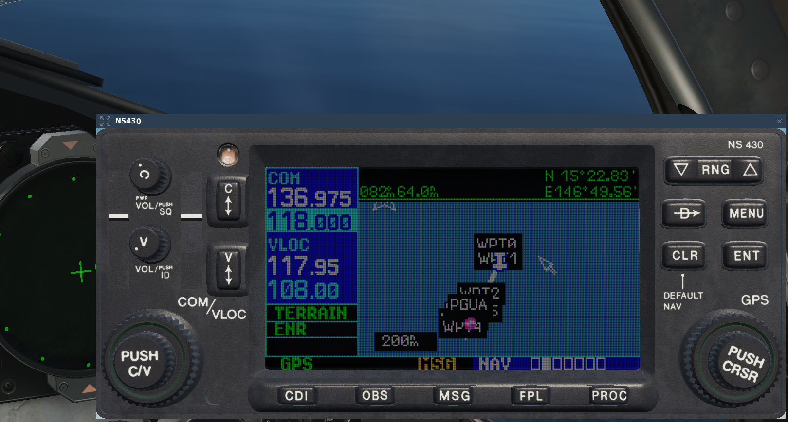
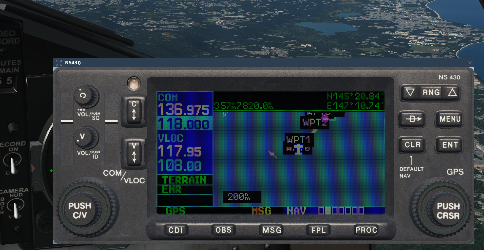
And I forgot... Alright, here's a screenshot form the Marianas F-15C freeflight instant action, note the coordinates (cursor east of aircraft postition, North-up mode) And here's the same situation, but in Track-up mode, cursor again on the east side of the aircraft (left side): I wasn't on active pause so the aircraft moved a bit (as you can see from the background) but that is besides the point. As you can see, in the track-up mode the latitudes are completely bonkers and exceed the limits for 90 degrees N/S by some 55 degrees Regards, MikeMikeJuliet
-
I would imagine that if we get a tutorial considering the radar, then we can surmise that the module release is imminent. As long as no video covers that we can safely assume that the radar is not functioning properly yet and will thus hold the release. This is my guesstimate anyways Regards, MikeMikeJuliet
-
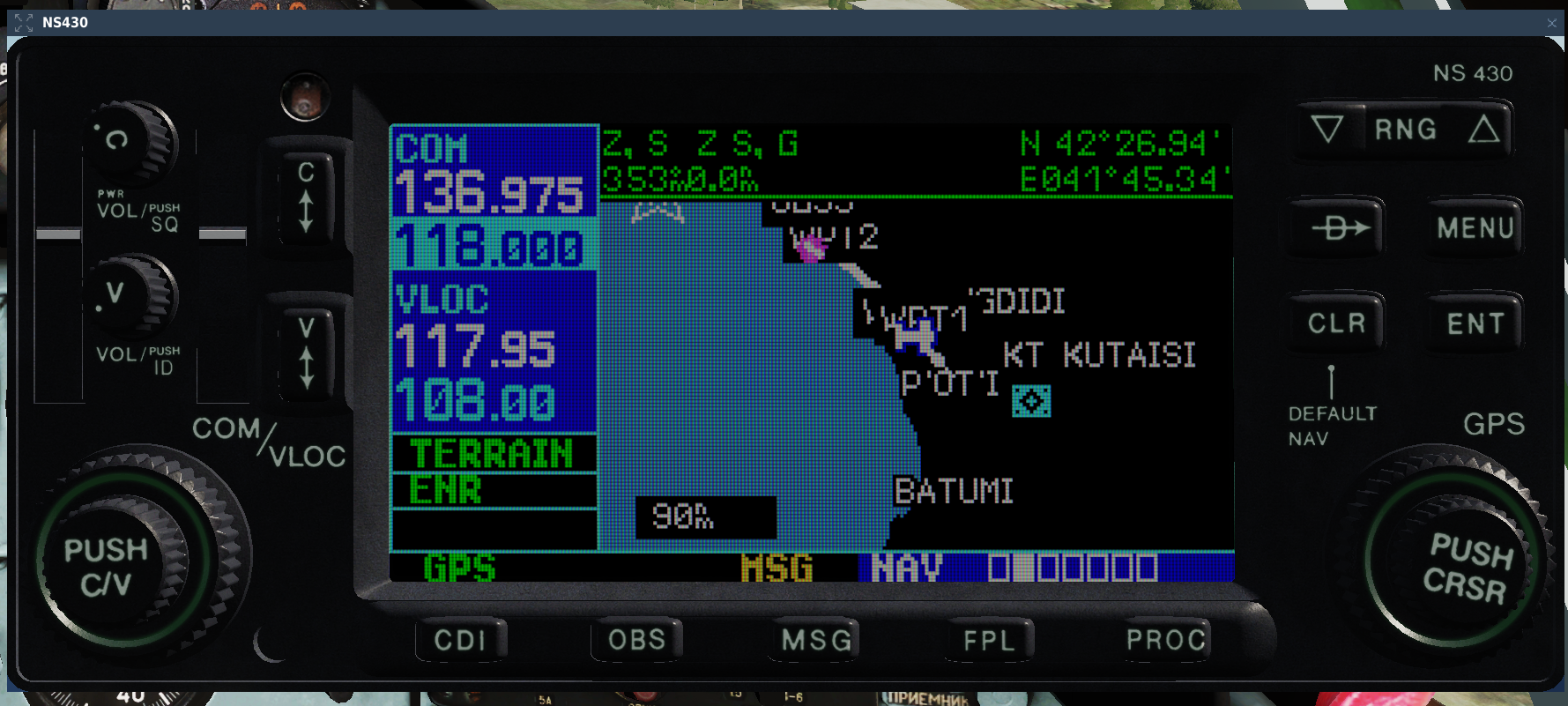
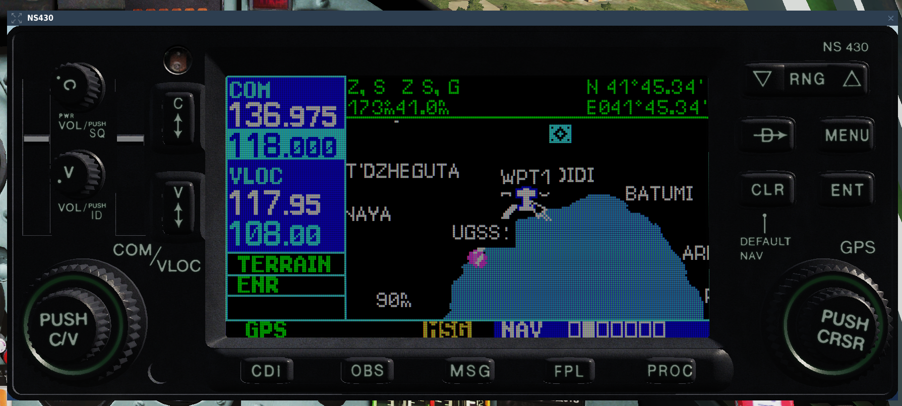
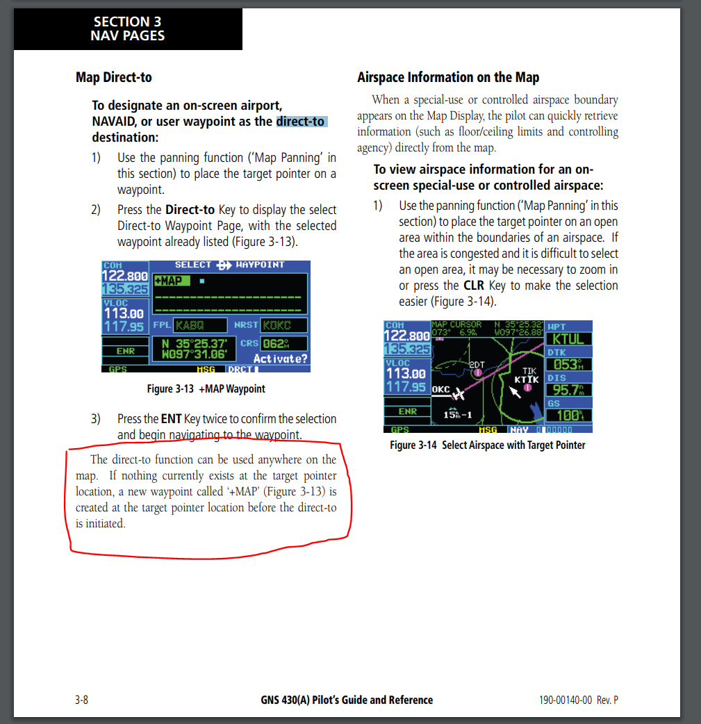
Hello! Having used the real counterpart to the NS430 quite a lot, I am requesting a feature to be added to the cursor when in map mode. Currently: When you activate the cursor when in the map screen and move the cursor to any arbitrary location and press the Direct-to -button, the NS430 presents you with either your current location (the airfield you are at if you are on the ground) or alternatively the point that the cursor is over (though this bugs out at times). Request: As per the real device, if you set the cursor at a point on the map where there are no waypoints (user generated or otherwise) the device should present you with a new user waypoint marked "+MAP" with the current cursor coordinates. This allows the user to set their destination quickly to any point on the map without needing to first navigate to the user waypoint menu and then build a new waypoint by setting coordinates. The following picture is taken from the official GNS430 manual (https://static.garmin.com/pumac/GNS430_PilotsGuide.pdf) Regards, MikeMikeJuliet
-
A little update on this topic. I just tried to replicate the bug on the Mariana islands, and you can see the bug there in action very well. In essence if you set the Track-Up mode and activate the cursor in the map screen, you will see your latitude at around the same ballpark as your longitude (which should be impossible, given that the longitude is around 140-150 degrees, and latitude naturally goes up to max +/-90 degrees). I will try to post a screenshot later today.
-
Yeah! I really like these "a bit of modern things, but still very much analogue" -types of aircraft. Really waiting eagerly for the F1
-
I do really think the only reason is that back in the day when DCS was built (or rather the core which is way older) one system was chosen instead of implementing multiple, because there is no reason you couldn't play just fine with what we have now. As a counter point to this being a tecnical limitation, consider the following: in VR this already works when using in-game menus (the esc-menu for example). While the menus are active the mouse is locked to the scene and you can look around just fine. No warping or twitching of the cursor (as if this was done by somehow compensating the motion due to head movement after it has moved). It's solid. It works and it is wonderful! Problem is it does not work in any other instance. And I believe the reason is just simply that no-one ever found it that necessary to implement before. I would argue that this would definitely be an option to be implemented. I know I and many of my friends would switch instantly. At the same time I know a lot who prefer the current system. Hence options. Regards, MikeMikeJuliet
-
Hello, it seems that there is a bug when setting up user waypoints via the map cursor while the map is in track-up -mode. In said mode the waypoint seems to get the correct coordinates as was shown in the cursor info-box, but then when I set the navigation to said point, the waypoint is far away from where I originally put it, even though when I check the coordinates from the user waypoint list all seems to be correct there. If you use the north-up -mode everything works just as intended. So it seems, that even though the NS itself show the proper coordinates, the actual position is copied from the screen as if it was north-up. Very confusing indeed! I found this flying in Caucasus. Haven't tested on other maps. Testing is simple: set the map to track-up, fly somewhere other than north and try to set up a user waypoint via the map (notice the coordinates!), set the direct-to function to the waypoint you just created and observe the result. Regards, MikeMikeJuliet
-
What has been the closest that two modules have been released from eachother, not counting campaigns? Because I don't think ED wants to push modules out too close together even if they do not directly affect eachothers sales. Q1 does not necessarily have a january patch since ED usuaöly have their holidays through much of january... and give that major patches come out once a month now *and* the Apache is most likely coming out first, it could be that March is too early for the F1. Hopefully I'm wrong and we do indeed see the Mirage out sooner rather than later, but I have my reservations at this point. Then again if ED get's to squeeze the Apache out end of January it could be that we might see the F1 com out in Q1... "Soon" in DCS-terms is, typically, actually something between "not quite so soon" and "around a year from now" Regards, MikeMikeJuliet
-
Yes please!
-
I understand your frustration, but at the same time I ask you, where did I say that this ought to take priority as no.1 fix for the F-15? The way you have formed your answer gives out the impression that no bugs/oversights are allowed to be reported before every bug/oversight more important than the one being reported are addressed. And by making that priorisation you also imply that you know the absolute order of issues to be fixed/improved on the module. Regards, MikeMikeJuliet Thank you!
- 11 replies
-
- 3
-
-
- altimeter setting
- keybinds
- (and 2 more)
-
Hello, most of you probably know this already, but I'm bringing this up again. The F-15C (and the A-10A) does not have any altimeter setting keybinds. This effectively means that the barometric altimeter cannot be adjusted, which is a critical oversight especially considering the probable rise of instrument flying due to the new (amazing) clouds and the upcoming weathersystem overhaul. This has been an issue for years. I believe I last posted about this like 4 years ago. The other FC3 aircraft apart from the A-10A have the binds (so the A-10 should get these too, along with the F-15) and the do work, for reference. The name for the keybinds are: "Altimeter Pressure Decrease" and "... Increase". I hope this is finally resolved to bring all the modules to the same state systems-wise within the FC3. Regards, MikeMikeJuliet
- 11 replies
-
- 2
-
-
-
- altimeter setting
- keybinds
- (and 2 more)