=475FG= Dawger
-
Posts
1932 -
Joined
-
Last visited
-
Days Won
1
Content Type
Profiles
Forums
Events
Everything posted by =475FG= Dawger
-
Is anyone experiencing this? I have received recently several reports of gradual loss of power resulting in inability to produce enough power to fly after 30-90 minutes of flight. I have only experienced this once, which I attributed to damage from gunfire but this was a month ago. Anyone flown recently and had this happen in the absence of possible damage?
-

Mig Killers AI Evading into the ground
=475FG= Dawger replied to Nolan17's topic in Aircraft AI Bugs (Non-Combined Arms)
A kill is a kill -
I know the feeling but I seem to have a lot of aeronautical minutiae just burned into my brain. Of course, having done an extraordinary amount of partial panel in real weather might have had that effect regarding this particular topic.
-
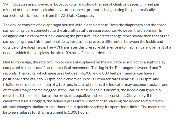
Reading the description of the VSI in the Phantom, it has the traditional multiple second lag inherent to a VSI that does not utilize accelerometers to make it "instantaneous". In this case the VSI (VVI) is counterproductive for trying to maintain level flight and should be ignored completely when doing so. The altimeter is the primary reference for pitch control. Excerpt from Heatblur manual

-
It is pretty easy to work up some scenarios that work for the F-5 and LGB’s. I used to have all that but I think its gone
-
This is incorrect. Altimeter is always instantaneous. When the altimeter needle stops, that is the required pitch attitude for level flight. There are instantaneous VVI/VSI but not all are instantaneous. Does the DCS F-4 behave correctly? Who knows.
-
450 knots IAS, altitude in the Twenties and a level drop 7 miles from the target will get you in the ballpark for GBU. We used to do this all the time in Alpenwolf's Cold War with a human JTAC lasing on the ground and giving us the mileage to target. But if you know the target TACAN radial and DME, its pretty simple to work up a drop point using TACAN.
-
ME Time and In-Game Differ by 3 Hours on Syria map?
=475FG= Dawger replied to DD_Friar's topic in General Bugs
ME time is local time. Aircraft clocks are, generally, UTC. You can see the Z on the clock indicating Zulu time zone, which is UTC Your mission location appears to be 3 time zones east of UTC- 1 reply
-
- 2
-

-

-
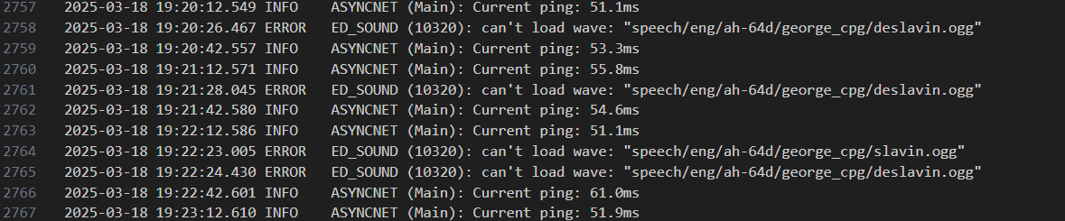
Long Lag when George is deslaving
=475FG= Dawger replied to =475FG= Dawger's topic in Bugs and Problems
Wilco but it will be awhile. Spring is sprung and we are going camping for a week. -
I am getting a long pause when George is commanded to do LOS search. The pause occurs when he tries to say de-slaving. nullSee the image for the error message associated with this. Is there a fix on my end I can apply?
-
By steering bug, I assume you mean a bearing pointer. With a bearing pointer, you must always keep the bearing it is pointing to the same in order to correct for wind. The course line drawn with a direct TO function is just a permanent representation of that initial bearing.
-
A constant direct bearing to the chosen location would result in a curved route that could spiral the station due to wind.
-
Make sure the door is open and there is no aft gunner.
-
Left short
-
For the mp persistent mission server I manage, the present weather implementation works pretty well. I can quickly produce sets of different conditions tailored to the battle area. Since we aren’t trying to create conditions unsuitable for combat, I never use visibility lower than a couple kilometers and its really simple to create weather conditions of great variety that are constantly changing. We aren’t using entire maps so I have no problem if fog at X also causes fog at 1000 km distant Y. I understand Cfrags difficulties in trying to make a single mission do many different things. However, for me, this is the best DCS weather has ever been. Admittedly my perspective is solely MP.
-
My default F1 view is too far forward (VR)
=475FG= Dawger replied to sirrah's topic in DCS: F-4E Phantom
Just lean forward and press vr recenter -
Finger Four can be either right or left hand.
-
My experience includes extensive UK and European operations. Its funny that you mention it specifically, as the UK and Europe are famous in transatlantic crossing circles for the entire continent going below minimums simultaneously, making alternate planning very difficult at times. I think if you carefully review your own post, you will find that we are actually in agreement. Rivers and relief variation. The original premise of this thread is that we should have the ability to set fog on a 'local' basis. I take that to mean at specific airfields and maybe a ten mile radius. Your post appears to initially agree with that premise until you mention 'Rivers and relief' As an easy to understand illustration, let's say we are standing on Shakespeare cliff at Dover. From our vantage point, the weather is clear and sunny but as we gaze below we see the top of a fog layer over the Channel. Mere feet away, the weather is very different because of the variation in relief. Is this same situation achievable in DCS? yes. Is the reverse? Can there be 'fog' at the top of the cliff with none down at the beach? Maybe, except if there is no fog on the beach and you look up at the cliff and it is shrouded in 'fog' we would call it 'clouds' although up on the cliff it sure looks like fog. Is this something achievable in DCS? Mostly. The cloud base adjustment is pretty limited. If we go inland and pick two points. RAF Coningsby can be socked in with fog at its elevation of 24 ft MSL while RAF Anwick, a few miles away, could be sitting in the clear at 200 ft MSL because air is a fluid and cold air sinks. Is it likely Anwick would be socked in and Coningsby not be foggy? Unlikely. When you fly over fog banks, one of their distinctive features is the sharp dividing line created by terrain elevation. The fog ends at a precise elevation over extensive areas and as the air warms, that elevation gets lower until the fog is gone. We do not have the physical processes that actually produce and dissipate fog at our command in DCS. We cannot set air temperatures, rates of change, moisture content and its rate of change. We do not have simulation of ground based moisture sources such as residual precipitation or bodies of water. What we do have is a method to set the top level of a fog layer and its density and alter those two variables over time and this mimics real world fog behavior pretty well. Is it an accurate weather simulation in every detail? Of course not. Such a thing is not possible.
-
In my rather extensive experience with fog and weather in general, there is no such thing as ‘local’ fog. Sure, maybe some patchy fog in low basins or trapped in a valley but fog of the sort that concerns aviation tends to be widespread. Fog is just cloud that touches the ground and are subject to the same processes. You don’t really get local cloud patterns unless you are over the ocean, where you see clouds over islands during clear skies elsewhere. The current weather system in DCS is actually pretty realistic and requires a mission designer to understand how weather actually works and how to incorporate it.
-
Thanks for the suggestions. What I have working at the moment is this: _airbaseNeutral = _airbaseName..'Neutral' _G[_airbaseNeutral]() Apparently, this works for functions in the Global namespace.
-
I need to call functions using a variable to store the function name and then call that function using the variable. Anyone know how to do this? @Grimes
-
Hard to guess what you are doing wrong from your description. You need to be enter full point name not just number. 1W 1C 1T If there are there are already points in the prepoint list you need to press the bezel until you get to the end and get a flashing cursor
-
I would like a server enforceable option to disable the ability of AI Copilots/Gunners/WSO’s/RIO’s/GIB’s etc to spot enemy units. Granularity to select unit types to exclude would be nice but just an off switch for all AI spotting would be cool. Thanks in advance
-
You can give CTLD mortar teams target via CA.
-
"Downgraded" Documentation Requirements for modules
=475FG= Dawger replied to cailean_556's topic in Chit-Chat
It is in the Solar system, so lots of competing gravity wells to move things around. It does look interesting, more interesting than Gen 5 fighters, in any case. Thanks for posting that