FalcoGer
-
Posts
1193 -
Joined
-
Last visited
Content Type
Profiles
Forums
Events
Everything posted by FalcoGer
-
George, you have been replaced.
-
The pilot could set FCR as sight and shoot on it with rockets though, using FCR as range source. It should be good enough for rockets, especially on stationary targets? Also does FCR detect "Armed house" or the guard tower thing as a target?
-
I don't actually know the vertical angle of the scanned area. Can anyone provide some insight? Also is the elevation indicator center of beam or one of the edges? Also I think my graphic is more "artzy" and has more character. [JK] Also given that the radar can actually measure distance to terrain, and is able to make a 3d map of it's environment, I wonder why an elevation control is needed at all, or why auto is so rudimentary, when the radar can just find it's own best settings by actually looking at the terrain outside instead of relying on simplistic assumptions that are often not true.
-
IAT also works just fine through bushes and trees. But woe you if they drive behind a transparent power pylon or something.
-
I haven't been able to fly since the update released. Is rocket engagement on FCR targets viable, I assume it doesn't do any lead calculations like using TADS as sight would do? Does coop work with CPG providing ranging through FCR (although it seems pointless?) Can CPG have TADS as sight and slave to FCR as ACQ (does PLT need to have FCR as sight for that to work?)
-
Bottom left on the FCR page. It looks like this Where the large dash indicates -6.25°. The dash above is 0° (as indicated in the image above). Each dash is spaced 6.25° steps. Top and bottom are 25° and -25° respectively. So the steps for GTM and RMAP are 25, 18.75, 12.5, 6.25, 0, -6.25 (default), -12.5, -18.75, -25. In ATM this is different. In ATM the default is +3° and each step is 5°. so the steps are 23, 18, 13, 8, 3 (default), -2, -7, -12 in ATM. As stated above, for TPM you can't set the elevation. It's a static -0.5° or -3° for a FAR and NEAR setting.

-
@Raptor9 Will the correct IDENT be saved when it is an RFI correlated radar track, when that eventually gets implemented? For example RFI detects an SA-8, and FCR correlates it with an ADU target. This would get merged into a single SA-8 radar target. When storing that target, will it be a generic TG or would it be an IDENT 8?
-
With link you can slave your TADS to your FCR NTS, or your FCR scan zone to your TADS. You can correlate FCR targets on the TSD with friendly control measures, but better yet you can create a no fire zone around your friendlies, so no targeting data gets displayed in the first place. FCR displays the symbols on the TSD. I'm not sure what you mean by that. Later we will also get the C-Scope function, which will put radar data on the HMD or TADS for GTM/RMAP and ATM modes, and obstacle info and terrain profile lines for TPM. This should help visually finding things much easier.
-
That's not entirely correct. This is only correct for single scan bursts. When operating in continuous scan bursts, the FCR can correlate tracks between each scan and retain the priority queue.
-
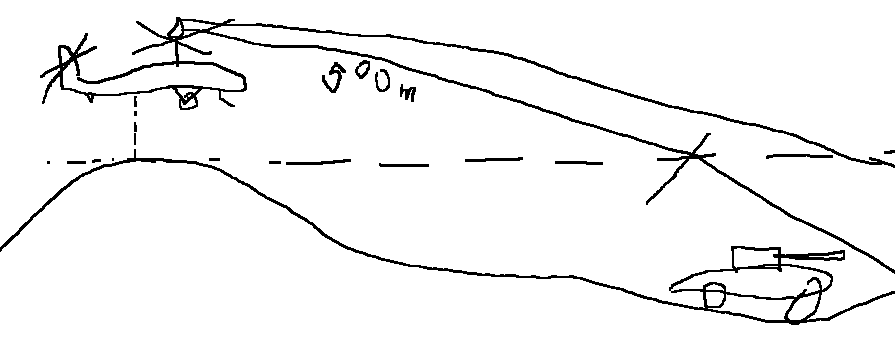
When in MANUAL elevation control, the MAN TRK on the TEDAC can be used for antenna elevation (if TADS power ON and FCR is selected sight), as can the arrows on the FCR screen. AUTO uses the aircraft's radar altitude to point the radar. When in AUTO mode, the radar elevation is supposed to be such, that the minimum range the radar scans at is 500m. This assumes a ground plane at the radar elevation of the aircraft. So when sitting on a hill and looking down into a valley, the minimum range will be pushed further away and the radar may scan above targets if they are too close. In ATM (Air Target Mode), elevation control is always manual and defaults to 3° up. In TPM (Terrain Profile Mode), the elevation is always static but can be selected between near and far modes where the elevation is static at -0.5° for FAR, which provides early warnings out to 2500m for high terrain and obstacles and -3° for NEAR for warnings out to 1000m. The sector scan size in TPM is dependent on air speed. For 0-55kt is is 180°. Down to and above 45 once triggered by 55kt it's 90° and fixed to center line. I spent a whole 30 seconds to make this helpful illustration.
-
This is what linking TADS to FCR is good for (FCR as sight, then sight select LINK), no? But from what I read, the LINK function is unavailable right now. I guess you could slave TADS to a TGT made with the FCR, or use ACQ on a radar return on the TSD.
-
Is this planned? I'm talking about the VIS Shading feature as found in the show page. What it does it shades areas in blue when set to own that can be seen from ownship/ghostship or from a terrain point (elevation of the point of view for that terrain point can also be set there), and it shades in areas that are visible from target/threat points in red/yellow, similar to the KA-50 ABRIS. This is helpful for planning routes that avoid air defenses, plan battle positions and help with engagements.
-
If the CPG is using the radar as sight and coop rockets, is that a valid configuration? Will the range be Rx.y km for the pilot then?
-

cannot reproduce Apache HUD and Track IR are ofsett
FalcoGer replied to Coenraad's topic in Bugs and Problems
If a restart doesn't fix that for you, you can configure a new neutral position. I think it's RShift+RCtrl+Num5, but not sure. Doing so sets the current camera position and rotation as the default. Personally I just have it look straight down the BRU to make alignment easier.- 1 reply
-
- 1
-

-
I never said I wanted forest fires. I just want a way to blow up the trees enough to get to the vehicles underneath.
-
They have to be kept track of anyway. Each tree has at least a 2d position, which is 2 floats or 8 bytes. an extra byte for a bool or 8 flags in a bit pattern in that single byte isn't going to blow more than a single tab in google chrome. Suppose there are 100 million trees (which is a stretch), that'd be 100 million bytes more, or 100MB. Barely anything. You can do even better and assume that most of those trees will never be damaged in a mission. Then you just have to store which trees are damaged in a list instead of storing that information for every tree. Which trees to store would be determined by some id for each tree (takes memory) or it's address in memory (does not use extra memory aside from storing those addresses (4 bytes each)).
-
CoordinateConverter - Alternative to TheWay
FalcoGer replied to FalcoGer's topic in Utility/Program Mods for DCS World
Sorry, but I don't know either. I'm using a plugin to create the installer and I didn't even write the configuration for it. You can install it manually by downloading Release.zip. Then follow the instructions in installation.txt. -
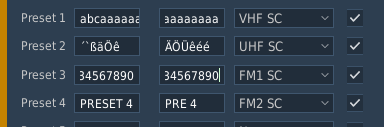
The text boxes in the mission editor where you plug in your radio data are unfiltered. They should only allow upper case letters, numbers, and the symbols available in the AH64 that are valid there. They should also stop accepting key strokes at 5, or 8 characters respectively. Entering invalid values here leads to problems in the mission.
- 1 reply
-
- 1
-
-
-
Terrain points are targets/threats. Check if you can see them if you switch to attack phase or enable them in the show -> coord show menus. I didn't fly the very latest update yet, but in 2.9 I could see them just fine.
-
I've had it work over FM2 just fine. The only thing that shouldn't work is HF.
-
speech recognition is hard to do. but windows has an interface for that as well. we will need something like this eventually anyway if they're going to model the EFA2000 properly.
-
VoIP is currently only available for the 2 analog radios, but the hornet can also receive on the two digital MIDS A and MIDS B radios, which provides a much clearer communication and also basically provides 2 extra radios to be tuned to, for example for intraflight communications without using up another channel. It might also permit to talk over one another without disrupting the transmissions, unsure about that, but that's what SRS does. It would be nice to have those extra radios available.
-
can not reproduce Autopage not syncronized in multicrew
FalcoGer replied to FalcoGer's topic in Bugs and Problems
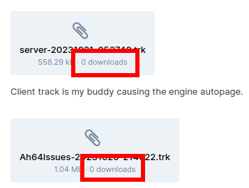
Thanks. I'm done with this. I did what I can. I don't know what to do if I put in effort in something reproducible and then ED just goes: "CNR, tough luck, won't fix." Also this upsets me. Every time I don't post a track they say: "We need a track, otherwise we won't bother looking at this and we can't see your setup or what you did." And every time I DO post a track nobody seems to download it and check it. So what is it? Do you need a track or not? And if not, then why do you ask for one? You know this is really rude. You ask for a track, I give a track and then you say you don't need it or it wouldn't help anyway. I feel like you're wasting my time after I put in effort to report an obscure but reoccurring and annoying bug for you.
-
ADF should be able to locate those who transmit on VOIP, even if they use encryption.