SlipHavoc
-
Posts
168 -
Joined
-
Last visited
Content Type
Profiles
Forums
Events
Everything posted by SlipHavoc
-
reported Changes to scripts fail integrity check again.
SlipHavoc replied to Im_TheSaint's topic in Multiplayer
Adding my voice to this as well... I have made a number of optimized autostart scripts (F-18, Ka-50, AH-64, C-101, Mi-8, UH-1, and Mi-24, all available in the User Files, and I have several more that I haven't published yet). I understand that the Cockpit/Scripts folder was added to the IC check in v.2.8.0.32066 in order to prevent some kind of MP cheating exploit, but there are no exploits in these customized startup scripts, they just use the exact same method that the default scripts use to press buttons in the cockpit in a specific order during the start sequence. I ask that you please prioritize making it possible to customize the startup scripts again without breaking IC, whether by allowing macro_sequencies.lua specifically (which is the only file that needs to be changed for these startup scripts), or by somehow limiting what can be called from that file so that the exploit can be prevented while still allowing custom startup scripts. Thank you! -
I did try feeding them into Google Translate, and what came out didn't make any sense in English, so I assume they're abbreviations or acronyms. CNCT MSL PWR seems like it would work.
-
FWIW, the manual says (page 443) "НАКОЛИ НИП" means "CONNECT MSL PWR", "ЗПС" means "rear aspect", and "ППС" means "front aspect" or "head on". A bit more on that first line: I think I would translate "НАКОЛИ НИП" as "CONNECT NIP", "CONNECT PWR", "ACTIVATE PWR", or "ACTIVATE MSL", something like that. "ЗПС" could be "REAR" and "ППС" could be "FRONT" or "H-O". Disclaimer: I don't speak Russian, and am only guessing here based on the manual and what I've tested so far by flying around a bit.
-
I haven't had a chance to test the BS3 in MP yet, but I did find this bit in the manual, page 519: "Erroneous transmissions and inaccurate ABRIS positions will be displayed on the ABRIS if other players join with the same ID’s that are on the same frequency."
-
The IFE discord got a post a couple hours ago in the news channel:
-
Can't complete mission 4 of the campaign (spoilers)
SlipHavoc replied to SlipHavoc's topic in Missions and Campaigns
Sorry I haven't had a chance to try this out yet, only just now got a chance to sit down and do some more testing. I actually opened Georgian Campaign-4-Ship SAR.miz in the Mission Editor though and I think I found my problem... After the rescue is complete and it says to RTB, I took that a bit too literally and headed directly back to Kutaisi, staying below 2500 ft the entire time as I didn't want to try a blind descent through the clouds. Therefore, because I never entered the "IP" trigger zone, the ATC_LAND event never fired, nor any of the following events including the mission ending. (Also the MUSIC trigger never fired since I was too low.) I'm pretty sure everything will work if I just fly the rest of the flight plan after the SAR mission completes. One other thing... Kutaisi only has ILS on runway 07, but the landing approach with the waypoints is to runway 25, so the player will not be able to do an ILS approach. And the wind at ground level is blowing to 330 deg (from 150), which should make 07 the "active" runway (at least from what I could tell in my ILS testing here) although barely. -
For me, autostart is a big "yes yes", and I use it all the time, and have already made an optimized startup script for the MB-339, although I'll probably hold off from putting it up in the user files until the first MB-339 patch, as I expect that may change some bindings. However in the meantime, you can modify your Macro_sequencies.lua file, replacing all the cockpit-related lines with this block:
-
OK, I figured out why mine wasn't working... I forgot to set a wind speed and direction that made the runway I was landing on "active". Once I did that, the ILS worked as you described. I also noticed you have to set the HSI course to the runway's true (not magnetic) heading, and as you said, the instrument scan is not ideal, but it does work. Thanks everyone!
-
In mission 4 you try to find a ship in bad weather. Once found, a Mi-8 appears nearby to rescue the crew, and you are told to orbit until the helicopter leaves, then you are told to RTB. I flew back to Kutaisi and landed, but it never gave a mission complete message, and the menu says it's Failed. I tried playing it again and, after landing back at Kutaisi, using time accel to wait until the helicopter had also landed (at Batumi), but still got no mission complete message. Is there a trigger I'm missing somewhere? Also, and possibly related, when I tried skipping it in the menu, it shows Night Solo Trip as the next mission, even though that's mission 3, and skipping that shows Ship Search and Rescue again as mission 6. Skipping that one goes on to the next mission, TERRORIST BASE - SEEK AND DESTROY! Possibly something messed up in the campaign mission order? Thanks!
-
Hm, I'm not getting that on mine... The left side of my ADI shows a small red flag indicating it's not picking up something (and there's another red flag at the top of the ADI), and my HSI still just shows the steering indicator fixed at 000 deg. Which airport did you test it on and how did you set up the mission in the editor? I also tried pressing every button on the F/D (Flight Director) panel tot the left of the HSI, but nothing changed.
-
I think I'm following the directions in the manual (pages 79-82) but it's not working for me... Set the ILS frequency on the VOR ILS panel on the right console, PWR switch on, then press the VOR button on the instrument panel to the right of the HSI. The HSI should show the heading to the ILS, and the artificial horizon should show the glide slope alignment with the needles. But the HSI just has the heading arrow pointing north, and the needles in the artificial horizon stay all the way at the edges, even when I'm directly on glide slope. TACAN works fine, and VOR beacons work fine, but I just can't get the ILS to work. My test scenario is an approach to Tbilisi-Lochini, runway 31L, which should have an ILS freq of 108.90. I set the airport to Blue coalition (same as my plane). I know the Russian ILS equivalent (PRMG) only works in instrument conditions, so I tried at night and bad weather as well, still no luck. Any idea what I'm missing? Thanks! Edit: I figured out why it wasn't working. You need to do a few things: The runway you're landing on must be the "active" runway, which as far as I can tell, means there must be some wind, and the wind direction is such that the runway would be the one planes are using to takeoff and land on (that is, into the wind). (I haven't tested the parameters, but my assumption would be any wind speed, and direction up to 89 degrees off the runway heading either direction.) Then, tune the ILS freq and push the buttons as described above. Set the runway's true (not magnetic) heading as the HSI course selection. Then the HSI will show the localizer (horizontal deviation) and the small white caret on the left side of the ADI should be active and show the glideslope. The needles in the ADI will presumably not be working until the Flight Director is implemented later on, but in the meantime those will give you the info you need.
-
I noticed that if you add tip tanks in the rearming screen in the Mission Editor, they stay showing on the plane even after they're removed by right-clicking their pylon and choosing "Remove Payload"; they're only actually removed from the plane when you do "Remove Pylon", and if you then do "Remove Payload" again, they come back. This happens on both the MB-339A and MB-339A/PAN. Tip tanks seem to work correctly in the rearming screen in the game itself though. Attached images: tiptanks_before.jpg shows empty pylon graphics and no tip tanks on 3D model. tiptanks_after.jpg is after adding tip tanks, then doing "Remove Payload". Thanks!

-
For anyone making custom kneeboards, here are the folders: MB-339A: "C:\Users\<username>\Saved Games\DCS.openbeta\Kneeboard\MB-339A" MB-339A/PAN: "C:\Users\<username>\Saved Games\DCS.openbeta\Kneeboard\MB-339APAN"
-
- 8
-

-

-
From what I can tell, the Valve Index still seems to have the largest vertical FOV of almost any headset, and that seems like an underappreciated VR stat for flight simming specifically. A large vertical FOV allows you to glance down into your cockpit or at your HUD or gunsight while watching the bandit in a turn fight, and seems like it would be at least as important as the horizontal FOV. I think the Index also has a very large visual sweetspot (the area that remains relatively sharp and in focus as you swivel your eyes around the FOV), which also seems really important since moving your eyes is much faster than moving your head. I'm watching to see if any of the next gen headsets improve on those stats in particular, otherwise I'll probably stick with my Index for a while.
-
Yep, that was it. Thanks!
-
I'm not sure what this means. I can't seem to rearm with the the pilot's cockpit door either open or closed.
-
how to perform an aerodynamic breaking with the F1 ?
SlipHavoc replied to cmbaviator's topic in DCS: Mirage F1
Page 108 of the manual says: After touchdown: i ̴ 13°. It is advantageous to use aerodynamic braking by holding the nose high down to 120 kts. I haven't landed it all that many times yet, but I haven't had much trouble holding the nose high after touchdown, although it does seem to want to touch the nose gear initially. I've found that retracting the flaps keeps it from wanting to take off again, but that may just mean I'm landing too fast. I do agree that the drag chute is the way to go though, the brakes aren't terrible but they're not great either, and even with aerobraking it can be a long runout on landing. But the drag chute works great. -
It would not have occurred to me to put Vangelis and Robert Miles in the same genre, but now that I think about it, that kinda works... I would also add Jean-Michel Jarre to that list. However I found a YouTube video of the F1 menu music, and it sounds orchestral to me, rather than synthy. Which kind of makes sense, since the F1 is not an '80s plane.
-
Yep that's it, thanks! Full kneeboard path is: C:\Users\<username>\Saved Games\DCS.openbeta\Kneeboard\Mirage-F1CE Also pinging @Mr_sukebe.
-
I am also trying to find what the name of the kneeboard folder should be, posting here so I get pinged if this is answered. If I figure it out, I'll post it here as well.
-
It's explained in this video from SUNTSAG ANCIENT GAMER. When you add a plane in the ME, it fills in some of the advanced waypoint functions automatically, which is useful for giving AI planes some sensible default behaviors. But you may want to fill that in yourself, or not have the ME set it for you automatically, and that button enables or disables the auto-fill functionality.
-
How does the F4U Stack Up against the 190 and 109?
SlipHavoc replied to percydanvers's topic in F4U-1D
In addition to the video above, there's a historical document at ww2aircraftperformance.org comparing the F4U-1, F6F-3, and FW 190 A-4: http://www.wwiiaircraftperformance.org/fw190/ptr-1107.pdf To summarize, according to that report at least: FW 190 has a better climb rate at higher airspeeds, although not sure how the absolute climb rates compare at each plane's best speed. F4U is considerably faster than the FW 190 at sea level, about equal at 15k ft, and slower at 25k ft. The F6F was slower than the other two at all altitudes except at sea level, where it was equal to the FW 190. Roll rate of the F4U and FW 190 are about equal, which is impressive since the FW 190 is well known for having an excellent roll rate. Turn performance of the F4U and F6F were "far superior" to the FW 190, both being able to get behind the FW 190 from a head-on merge within one full turn. General maneuverability of the F4U and F6F was also better, with tighter loops, better behavior in tight turns (FW 190 tends to drop a wing abruptly), and formation flying was easier due to finer engine control. Forward visibility was considered to be worse in the FW 190 vs the other two, but rear visibility was better. The general recommendation given for F4U and F6F pilots is to get close and beat the FW 190 in a turn fight. In my (limited) experience the FW 190 is best used in hit-and-run attacks, diving on an unsuspecting target, blasting it with massive firepower, and then running away, so that kinda lines up with this report. Also worth keeping in mind that these comparisons could change significantly with the specific variants of the planes, and even with things like propeller type and other factors. One thing pointed out in another Greg's video is that US Navy planes were not particularly optimized for high altitude, as the main threat was from dive bombers at medium altitude and torpedo bombers at low altitude; level-bombing ships from 25,000 ft is basically impossible, even if the Axis powers had the planes to do it, which they mostly didn't. Whereas even very early in the war in the European theater, high altitude performance was emphasized for bombing and recon, and escorting those planes. -
There's at least a few dozen airports in the map area that aren't modeled yet, ranging anywhere from overgrown and abandoned strips, to short dirt or grass local fields, to full-sized airports with paved runways and facilities for passenger jets. I found a site that shows all or most of them, and allows filtering: https://hub.arcgis.com/datasets/e90996158f0a464189098881379597a6_0/explore?location=-52.911028%2C-65.627450%2C7.00 . (And here's another that shows most of them, with some other info: https://metar-taf.com/ ) So for instance, here are 11 airports with runways at least 4000 ft long that I was able to put together with a few minutes of clicking around: Guardiamarina Zañartu Airport latitude: -55°55'51"S longitude: -68°37'34"W San Sebastián Airport latitude: -54°18'58"S longitude: -69°39'26"W Rio Chico Airport latitude: -52°40'6"S longitude: -70°15'37"W Lieutenant Julio Gallardo Airport latitude: -52°40'14"S longitude: -73°31'44"W 28 de Noviembre Airport latitude: -52°36'17"S longitude: -73°13'13"W El Calafate - Commander Armando Tola International Airport latitude: -51°16'49"S longitude: -73°3'11"W Santa Cruz Airport latitude: -51°0'59"S longitude: -69°34'45"W Capitan D Daniel Vazquez Airport latitude: -50°18'24"S longitude: -68°48'9"W Gobernador Gregores Airport latitude: -49°46'59"S longitude: -71°9'0"W Villa O'Higgins Airport latitude: -49°28'9"S longitude: -73°33'51"W Los Robles Airport latitude: -55°4'8"S longitude: -68°39'12"W The map textures clearly show the runways and airport facilities, so hopefully these and others will be added as usable airfields in due time. Right now, there's only 4 fields on the mainland and some interesting parts of the map are hundreds of miles away from the nearest one, so adding some of these could really open up the map and allow a lot of different missions. And the smaller runways could be very useful as staging areas for Harriers, helicopters, or prop planes.
-
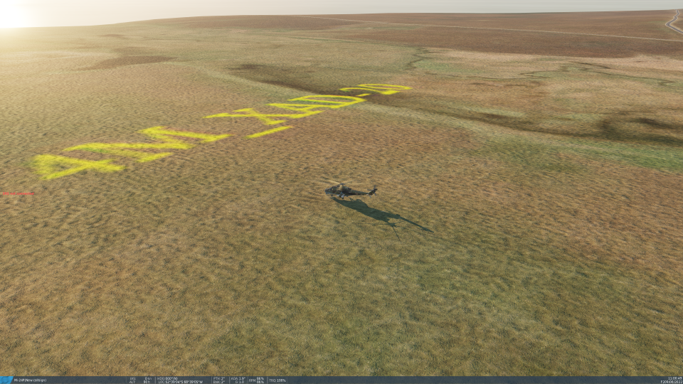
I happened to stumble on this randomly, some text overlaid in the satellite photo, which is now part of the ground texture. Text reads "4M_XAD-20". Location is 52°39'01"S, 68°38'57"W, grid square ET26, about 0.8 nm south of Estancia Shangri-la. In-game screenshot attached, reduced from 4k resolution.
-
I have done a little testing at extreme temperatures, but not as much as I should, thanks for the reminder. And yeah, the styles vary wildly, you can really tell the older modules and how ED has learned as they've gone. My biggest challenge so far was the Ka-50 script, which is probably the oldest in the game. I did a ton of clean up on it and brought it almost all the way up to the current code standard, but fully updating it would require modifying at least command_defs.lua and maybe other files, and that's more than I want to bite off right now...