Ramsay
-
Posts
3750 -
Joined
-
Last visited
Content Type
Profiles
Forums
Events
Everything posted by Ramsay
-
As far as I can tell ATM there are only models for sheep and whales. "Falklands\Models\Razbam_Animals\StructTable.sht" lists • Sheep_Ram_01 • Sheep_01 • SA_Orca_01 • humpback_whale_01 Sheep can be found in the fields just north of Goose Green. I haven't spotted any whales yet but apparently they are "Civilian Traffic", and Humpback Whales can be found in Stanley Harbour if Civ Traffic is set to HIGH.
-
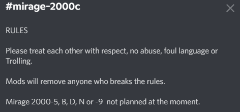
AFAIK (via Discord) Razbam have no plans to model the M2000-5 in the near term, ... as to what might be available in the future, that will likely depend on AdA's requirements and how much (if any) they are willing to share publicly. AFAIK there's not enough publicly available info on the 2000-5 to make a DCS level module without the help of the AdA.

-
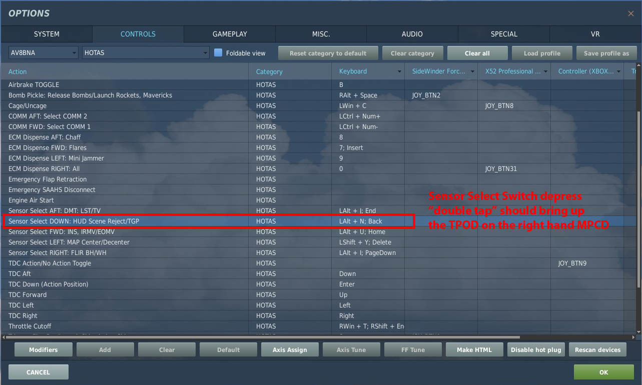
Yes, it's Sensor Select Switch depress double tap, to bring up the TPOD on the RH MPCD and Enter/Exit TPOD HOTAS Mode (HTS). The mode it'll start in will depended on the aircraft's current status i.e. is there a waypoint/target designation or similar to "slave to". You can see the SOI source and designation on the TPOD's display. If it's not in TPOD DES at first, it'll usually switch to that mode once you start/stop slewing the cross hairs (IIRC it's important for the slewing to stop, so if using an analogue axis - you may need to add dead zones to stop drift). Before switching to another mode/weapon, AFAIK the AV-8B requires you to create a Target designation using TDC depress "TDC Down (Action Position)" Here's a rather poor video of me using the TPOD to find target's to fire IRMAV at. @RebelCid If you still have issues please share a screenshot or short track (i.e. an air spawn) of you using the TPOD and I'll try to spot your problem.
-
Aerodrome Data and Frequencies - Updated 26 October 2025
Ramsay replied to Minsky's topic in General Tutorials
Because the author of these charts has chosen to display DCS "TRUE (F10 map) to MAGNETIC" conversion values rather than the Magnetic Declination/Variation. The website calculates RL MagVar's across the globe using the World Magnetic Model WMM2020 which uses historical data to predict past and future MagVar's. Note: DCS uses WMM modelling data from 1985 - 2020 to calculate/extrapolate it's magnetic compass readings.
-
Aerodrome Data and Frequencies - Updated 26 October 2025
Ramsay replied to Minsky's topic in General Tutorials
No, IRL most of the time you'll measure a bearing using a magnetic compass and want to compare the bearing you measured to a Survey Map aligned to TRUE North i.e if you were to stand at the start of Akrotiri RWY 28 and measure it's magnetic bearing you'd read 286°M. To get it's TRUE bearing, you'd add the local MagVar TRUE = MAGNETIC + MagVar = 286°M + (+5°) = 286°M +5° = 291°T ... and use that to draw the runway/final approach on the Survey Map. Aviation approach charts are an exception as they are usually aligned to Magnetic North except in countries like Russia or near the magnetic poles where MagVar has large changes over short distances/periods of time. -
Aerodrome Data and Frequencies - Updated 26 October 2025
Ramsay replied to Minsky's topic in General Tutorials
It's the opposite, a magnetic declination of +5°E means you ADD +5° to a magnetic compass to get the TRUE bearing. In the video, he subtracts 5° from TRUE to calculate the MAGNETIC heading of Akrotiri RWY 28. Because he's using the F10 map ruler to measure Akrotiri RWY 28's true bearing = 291°T i.e. He knows the TRUE and want's to calculate the MAGNETIC bearing the compass in the aircraft should read to fly the final approach. Magnetic = True - MagVar = 291°T - (+5°) = 291° - 5° = 286°M -
The intrinsic problems with the Gazelle's FM are deeper than missing rigid rotor hub features, hence Polychop's decision to redo the Gazelle FM afresh based off their improved Kiowa FM adjusted with feedback from Gazelle SME's, etc. This is my current understanding of the Gazelle's FM
-
There have been adjustments to how control/joystick inputs "feel" (best used with the dev's recommended curve and saturation settings) and it's in active development ATM with new gun and rocket pods being added to it's loadouts and multi-crew improvements that allow both pilot and commander interact with the same switches. However, the current FM still has it's known limitations (to fix those will require the updated/improved FM modelling developed for the Kiowa). TL;DR: It's said to have the light control of the "light helicopter" it is but is missing some important FM features, it's still one of my favourite helicopters to fly in DCS and I have plenty of flight hours if I aggregate my time flying the M, L and Mistral versions - but obviously YMMV. Why not use the 14 day "Free Trial" feature of DCS Standalone to try the Gazelle for yourself.
-
Is there a progess info of the Assets Pack?
Ramsay replied to Eisprinzessin's topic in South Atlantic
There's another Open Beta patch planned for June. https://forum.dcs.world/topic/233848-patch-status/#comment-4984291 -
When flying the DCS Apache, yes. The Apache has many MFD's, the IHADS, etc. i.e. if you look over your CP/G's shoulders you'll see their screens change/render accurately as they change weapons/modes. This plus the normal FPS hit of rendering rotor blade shadows, etc. mean we simply don't get the high fps you are looking for without dialling down the settings for VR or using texture replacement packs. I feel ED probably have done as well as they could, as the Apache's FPS isn't much lower than the Mi-24P/Mi-8 (obviously I'd like better but I don't think it's an easy fix).
-
Same, I know it's lazy but it gets the job done and allowed me to quickly sample the Falklands and test out the newest Mirage changes. This too. When creating my first free flight mission around Cyprus, I needed to read up on the island and it's history before I could appreciate what was (and was not) modelled in DCS. I imagine creating missions for the Falklands will be similar but will use historical weather from the "war" to get a proper "feel" for flying and fighting over the islands.
-
So there are ~35 aircraft in DCS, you expected the dev's to create (and maintain) 35 free flight missions (most of which wouldn't be used) because you can't or don't want to use the mission editor. The South Atlantic Map is an asset pack for mission makers, there are no period/country specific aircraft in DCS yet, I'm sure eventually there'll be a few missions included but IMHO the focus of the dev's to improve the map is correct and not to waste their time (and ours) creating filler content to tick someone's "checkbox".
-
I don't see anything obvious ... it's the default SP AH-64D Persian Gulf "Mountain COIN" mission, the track played for ~25 minutes, ending in the middle of a blue on blue hellfire attack on a US outpost/convoy on the FLOT. It didn't CTD for me, rather it ended and returned to the DCS debriefing screen. Looking at the differences between the track's options.lua and my defaults • OPTIONS>MISC --> Random System Failures = ON (which may be an issue as the Apache is in EA and random failures might not be modelled yet) • OPTIONS>SYSTEM --> Vsync=OFF (meant my GPU was running at 100% for the whole mission - with slightly lower GFX settings but 4-6 fps faster). Perhaps as CP/G you inherit the pilot's settings ? I'd try disabling System Failures in case it's causing problems (at this stage I'm just guessing and it's a process of elimination). I've had issues with one of Nvidia's latest drivers in another "Flight Sim", so it might be worth rolling back to a driver prior to the date of your first CTD, if you haven't already tried.
-
What's said is, that adding the TPOD to the Harrier was a bit of a hack and when the TPOD is powered up, the weapons system treats the TPOD as a A-G Missile, so powers off other missiles with video, hence the need to power the LMAVS backup. This can be avoided if you ensure that 1. TPOD is selected and powered up first (RHMFD) 2. then the LMAV is selected and powered up on the SMS page (LHMFD) 3. find the target using the TPOD as usual, TDC depress to designate a target point, then self-lase 4. SSS forward long, to see the LMAV's video feed replace the TPOD on the RHMFD before firing the LMAV Chuck's Guide says the E2 requires 30s to spin up it's gyros, so that's 4 nm @ 480 KTAS (unless somethings changed), so you should likely have this all setup to go at your ingress point. Note The DCS AV-8B's TPOD logic is said to be WIP but the aim is less to improve "usability" but rather to model it's idiosyncrasies, which apparently still isn't quite right in DCS.
-
Chart inverted in "Stolen content" AH 64 mission, Syria
Ramsay replied to Moxica's topic in Bugs and Problems
I have noticed rendering distances be a problem in Syria, with trees and buildings perhaps not appearing in the TADS until 20-15 km ? I'm not sure how this compares to the Caucasus map, as Syria has been my main AH-64D mission map with Caucasus reserved for training, but it is something I've learn to look out for / be aware of. -
Chart inverted in "Stolen content" AH 64 mission, Syria
Ramsay replied to Moxica's topic in Bugs and Problems
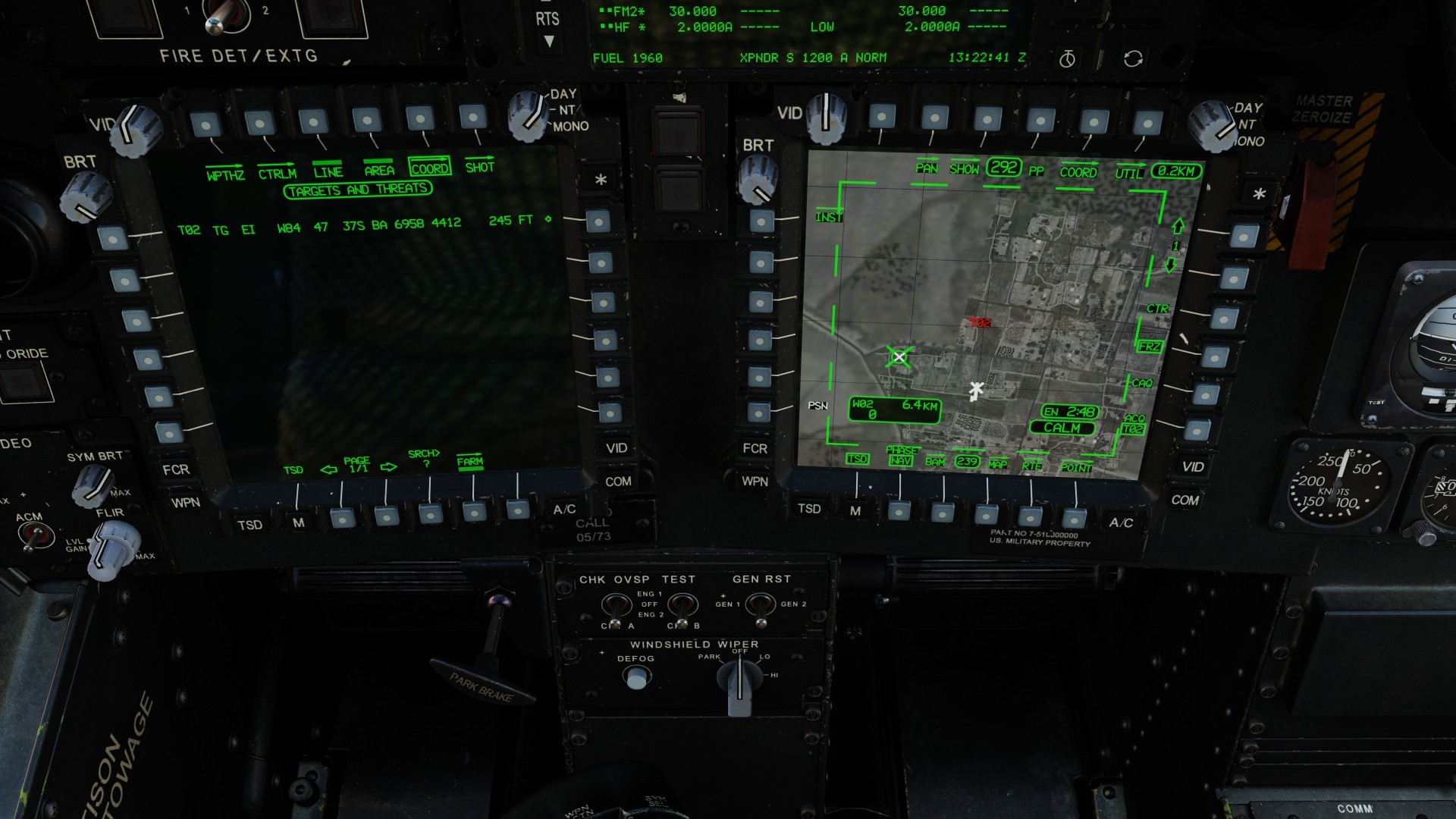
I'll assume you used map>chart>Sat as the aviation chart and digital elevation types don't show buildings. The co-ordinates look spot on when I create a target point at those co-ordinates. Here the TSD map has been set to "North Up" before being panned, so the target's orientation matches the F10 map. What can and has caught me out in the past is, when you use "pan" to slew the TSD map, it's orientation is "frozen" to the current heading/mode (until unfrozen with R4). Here, I'm viewing the target while at the FARP and the default map "up" is aligned with the heading 292°M i.e. the south-north roads are running left to right. Perhaps something like this caught you out ?
-
Chart inverted in "Stolen content" AH 64 mission, Syria
Ramsay replied to Moxica's topic in Bugs and Problems
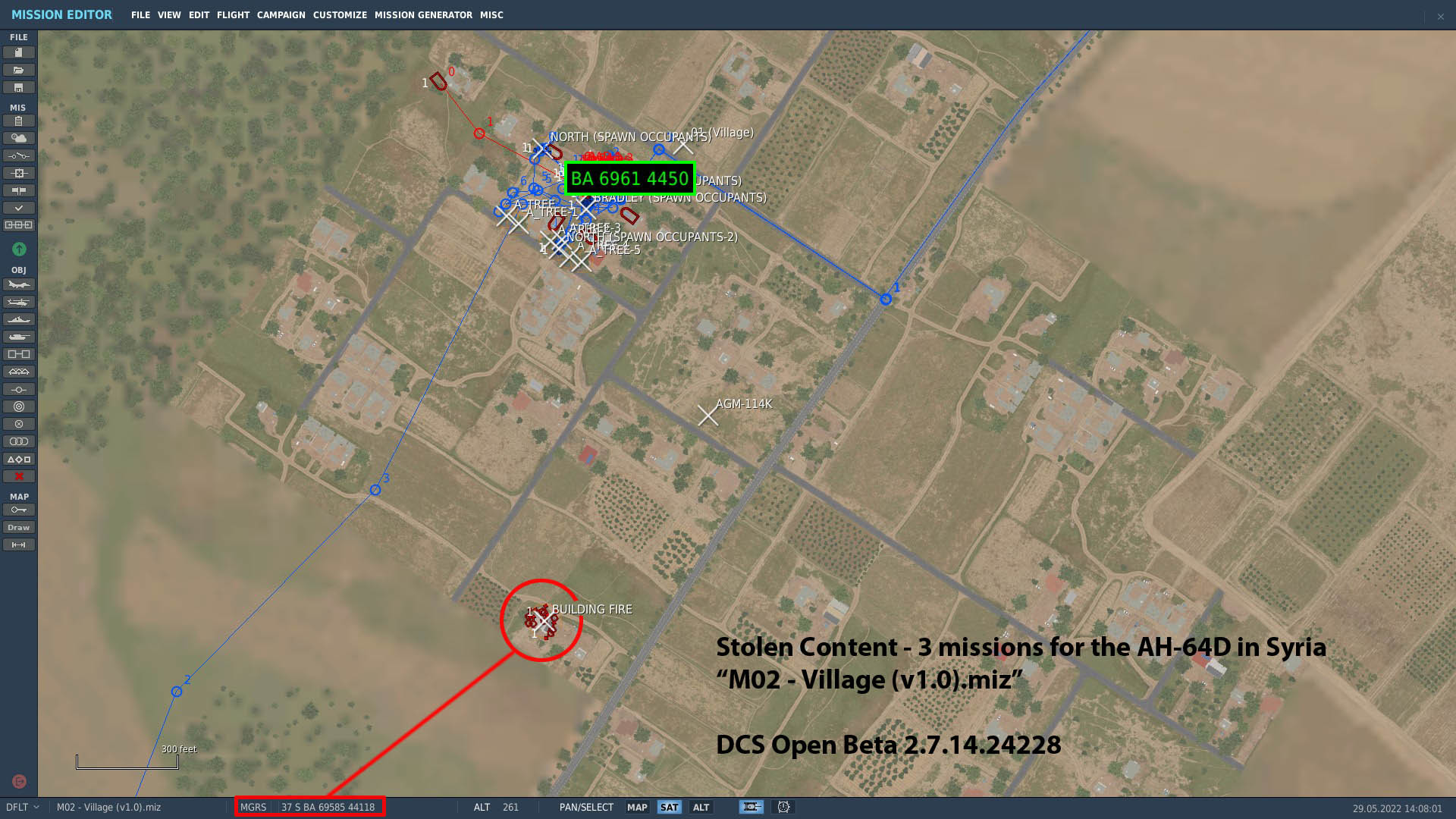
@Moxica If you are talking of the user created mission pack "Stolen Content - 3 missions for the AH-64D in Syria" Which mission and (TADS ?) chart are you talking of ? Are you sure the issue is "map" related and not related to the mission or AH-64 ? Edit: Assuming you mean M02 - Village, the coordinates look good There's also this video of the mission if it'll help you explain what is wrong
-
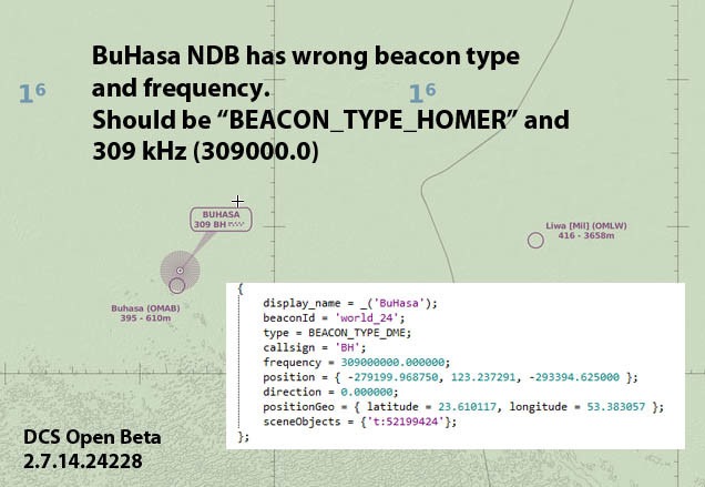
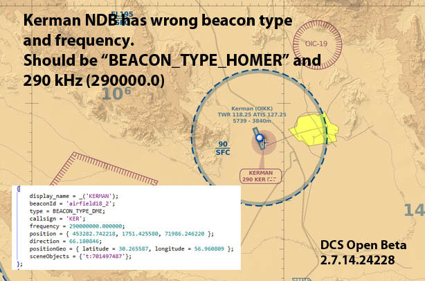
Note there are at least 2 other Persian Gulf NDB's with this issue in the current Open Beta. These NDB's BH and KER have the wrong frequencies (instead of kHz, they've been given MHz) • NDB BH 309 kHz --> 309 MHz • NDB KER 290 kHz --> 290 MHz ... and been given the wrong type • BEACON_TYPE_HOMER --> BEACON_TYPE_DME NDB BH NDB KER
-
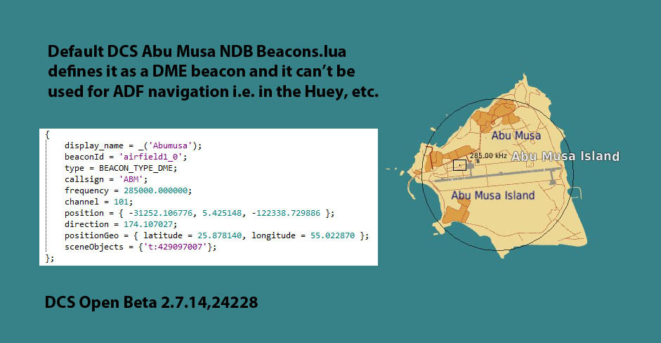
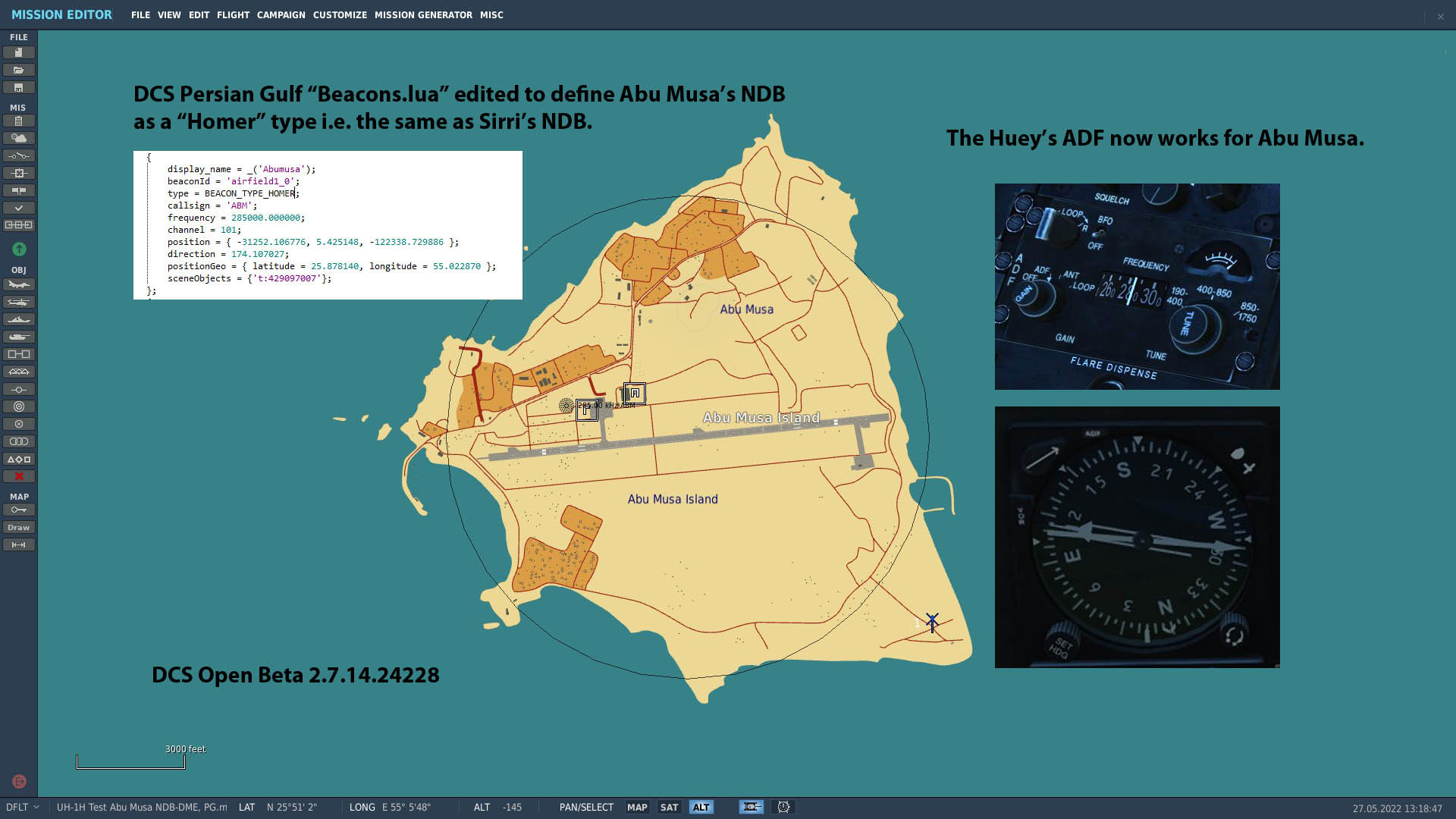
Abu Musa's NDB frequency is 285 kHz IRL and in DCS, however it's wrongly defined as a DME in Persian Gulf's Beacons.lua, so doesn't work for ADF. Abu Musa's default DCS NDB definition Sirri's NDB is correctly defined as a "Homer" in "Beacons.lua", editing Abu Musa to be the same beacon "type" allows it to work i.e. for the Huey's ADF Tested in Open Beta 2.7.14.24228
-
It's really hard to know what the "best" page file size is, although I have no issues with 32GB DDR4 and a 16GB page file in Syria, others have found they needed a 24GB Windows page file for stability. AFAIK (simplified explanation) Windows uses it's page file, when a program (DCS World) requests more physical memory, to quickly free up space. You may think that DCS World is using 18-24 GB RAM and the rest is FREE but Windows, GFX drivers and DCS don't let that FREE space go to waste. • Windows will use part as a RAM disk to pre-emptively cache files, etc. (why unload stuff if it might be needed later) • GFX drivers do the same for textures, shaders, etc. first using free VRAM and then system RAM. • DCS it self pre-loads textures, shaders, etc. ... while Windows tries to predict upcoming memory requirements, it doesn't understand DCS, so when DCS queries for height data from Syria's 17.9 GB "Syria.surface5" file it may run out of memory if the page file was set to "auto" (as Windows wasn't able to expand it's page file and make space in the system RAM fast enough). AFAIK, ideally page files and caches should be big enough to do their job (and no bigger), as there's a performance cost when searching through them. DCS's Syria map will take 56 GB RAM in a 64GB PC, so you could use that as a basis • 32GB RAM + 24GB Page File = 56GB ... I'm not sure it "needs" it but YMMV.
-
need track replay Heat trace on cold and dark Harrier
Ramsay replied to sirrah's topic in Bugs and Problems
Currently DCS aircraft have 2 IR "states - Normal and Afterburner. The Apache PNVS is accurately displaying the AV-8B's DCS Heat Signature, perhaps later ED will add a cold (engines off) state i.e. the new FLIR system is WIP, I'm sure 3rd party dev's will make use of any new features as and when they become available. Cold aircraft having a "hot" heat signature is one of DCS many older limitations i.e. cold aircraft being lockable by IR A2A missiles, etc.
-
Please attach your dcs.log the next time DCS crashes and you are flying the Gazelle. There are a number of important Windows/DCS settings that may cause DCS to run out of memory. • Fixed size Windows Page file (16GB-32GB, perhaps 24GB for Syria) - unfortunately the windows "auto" Page File setting doesn't seem to respond fast enough to DCS's demands, so DCS runs out of memory. • DCS Options>Preload Radius - uses up memory to preload 3D models, etc. Max was appropriate for slower systems/hard disks but with DCS's increasing GFX demands and the availability/use of SSD's it now needs to be balanced, even with 32GB of RAM. A large map with many unique/individual buildings can be very demanding for little gain using max radius. I don't have your issues with • 1920x1080 • Windows Page File = 16GB • DCS Preload Radius = 60,000 Please attach your dcs.log the next time DCS crashes and you are flying the Gazelle or Apache.
-
Some players use the diagram but ... ... like you, I find the channels don't match up with the TCN channels that "jam" the data link in DCS. Personally, I have a "white list" of safe TCN channels (created from experience with previous missions) I use. • Low channel numbers (1-4) seem safe • Channel numbers similar to CVN's (68-76) seem safe • IIRC TCN channels around 8-13 cause link-16 issues but as this is from memory, you'd need to test if you want certainty. History When DCS's link-16 was first released, by chance it conflicted with low TCN channels and CVN numbers, this caused issues for a number of user missions, so DCS's data link frequency was "tuned" by ED to avoid these. IRL link-16 data channel hops across a frequency "band" and never spends more than a few micro-seconds on any particular "frequency".
-
TL;DR: The 2 modules are not directly comparable, your decision depends on whether you wish to • expand your skills to radar, A2A BVR game planning, carrier landings, etc. or • learn a new skill - fly a combat helicopter Detail: • The FA-18C is an excellent multi-role trainer (has the 2nd highest flight hours of my modules) i.e. learning BVR game planning, etc. but it can feel a little anaemic/sterile to some, I have issues with some of it's BVR --> ACM workflow and find ED's AGM-84 Harpoon particularly underwhelming. Despite it's faults, I consider it an essential purchase for "most" DCS players. + It expands on your A-10C's battlespace/speed and poses a real A2A threat to enemy aircraft - but doesn't have access to anti-armor cluster bombs like the CBU-97/CBU-105 that the A-10C/F-16C carry. • The Super Carrier is essentially an "Asset Pack" for the Hornet, it's rather weak in content and has lower dev resources than flagship products like the FA-18C, F-16C, AH-64D, etc. Worth picking up in a sale to get a better carrier experience (animated deck crew, additional ATC voices, etc.). It's worth will depend on how much you use the ME and/or which MP servers you play on. • AH-64D - new kid on block, early access but more complete than most of ED's recent EA releases, it has a wealth of smaller system details modelled and a solid multi-crew experience.. + Learning to fly a helicopter is skill in it's self +/- Not directly comparable to the A-10C (as it's a helicopter) but has a smaller selection of weapons (rockets, cannon and hellfire) and smaller battlespace. + IMHO TADS/PNVS and MFD's make the AH-64D a better "fit" to DCS, than the Mi-24P though the later is more "old school", so may be preferred by some. +/- Takes your previous A-10C combat and takes it up close and personal but is working near the limit of DCS to model infantry support "realistically". +/- Makes the A-10C seem fast in comparison - Higher system requirements / lower fps - Mission designs may be more limited/repetitive I'm pleased to recommend either module as I find both excellent but YMMV.
-
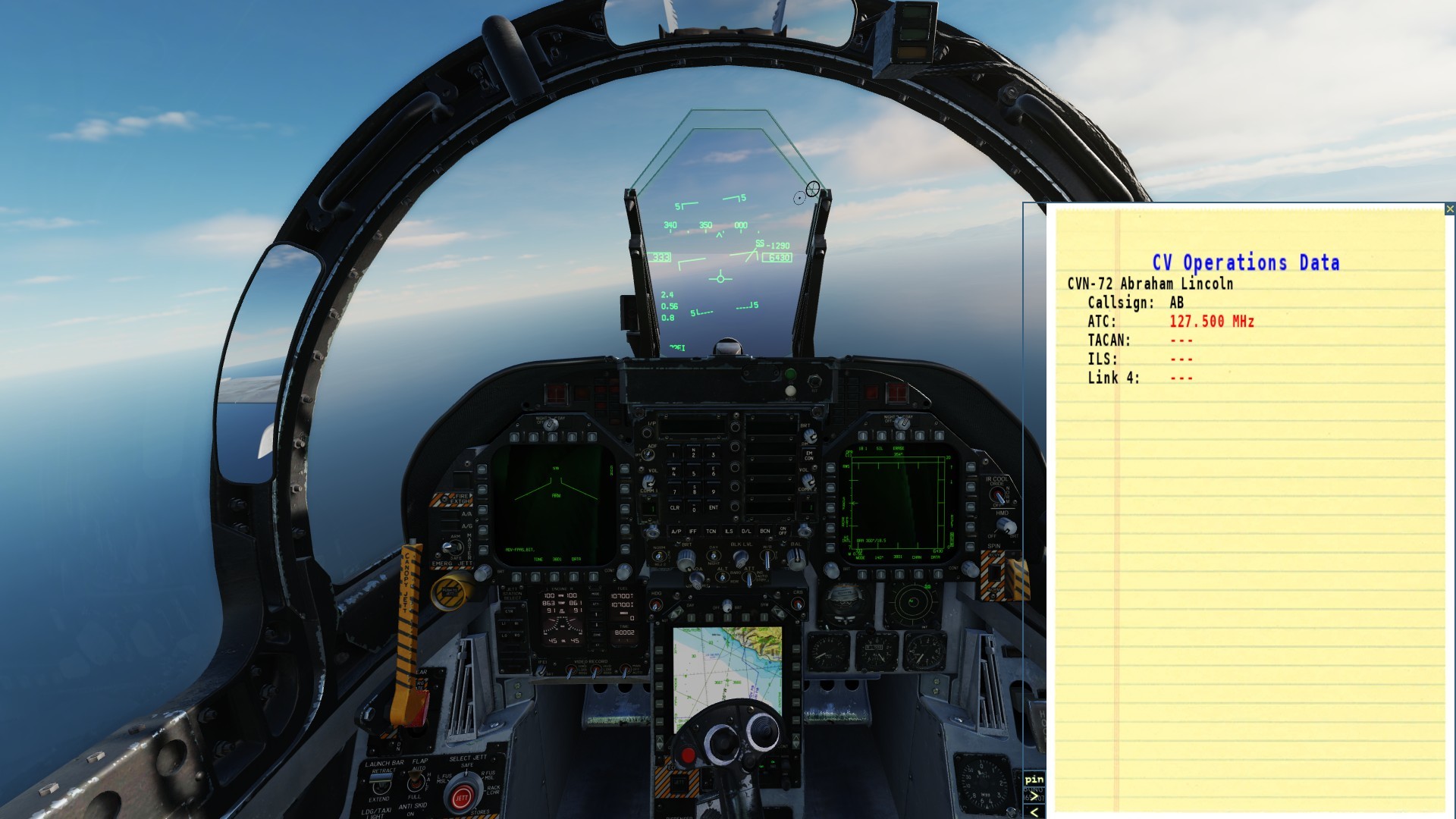
No work on my part, ED have coded it that way, I'm guessing the Hornet/kneeboard scans the mission file shortly after the player spawns in (the ACLS page details take approximately 15 seconds to populate if opened immediately) i.e. if I • start one of my test missions • open the kneeboard • hit pause ... the kneeboard looks like this However, if I unpause the mission, 13 seconds later the page will refresh with the correct TCN, ICLS and Link 4 details. I assume the OP has found a setting that stops the kneeboard from populating or is breaking the Link 4 in some way.