Ramsay
-
Posts
3747 -
Joined
-
Last visited
Content Type
Profiles
Forums
Events
Everything posted by Ramsay
-
Mirage F1 Fighter Weapons School - multi slot mission
Ramsay replied to Don Rudi's topic in Missions and Campaigns
This looks fantastic - only minor criticism I have is that in the .pdf you say on page 4 the magnetic declination of the map is -4° It is closer to +5°E
-
Not when core features such as INS designation are being reworked and the time frame of the module has changed from ~2007 to ~2017. New/updated systems have to be created/implemented, then checked/validated by SME's before finally being past on to Open Beta and/or documented in the manual. For example, to avoid reworking the training missions/campaign again and again, it was decided to only add them after the module was complete. After 2 years it was thought time to add the training missions, etc.as users were asking for them. Another 3 years later these "finished" missions need to be reworked again. This is what happens when the community ask for more modern weapons/systems (or an SME reports a bug) and the dev's listen.
-
What happens with the Hind (EA on standalone but not on Steam) is that it receives a 30% discount in Steam sales, while on standalone it receives a 20% Early Access discount all year. IIRC ED have said it's a limitation of selling on Steam. AFAIK the price is set by ED and Aerges, what Steam will not allow is setting an "indefinite" discount that might mislead buyers into thinking they are making a saving over the "regular/retail" price, when they are not i.e. a 50% saving on a ticket price that's never been charged to any buyer ever.
-
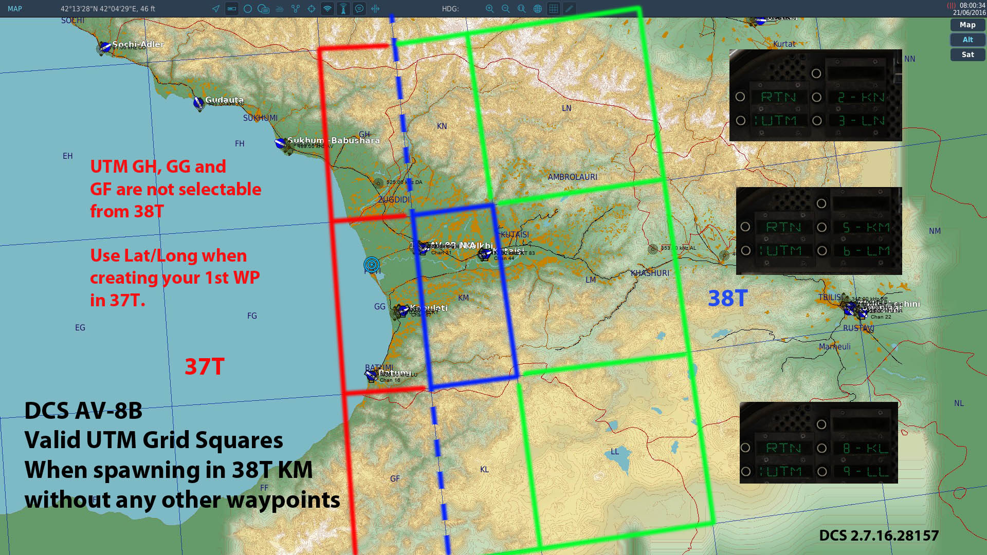
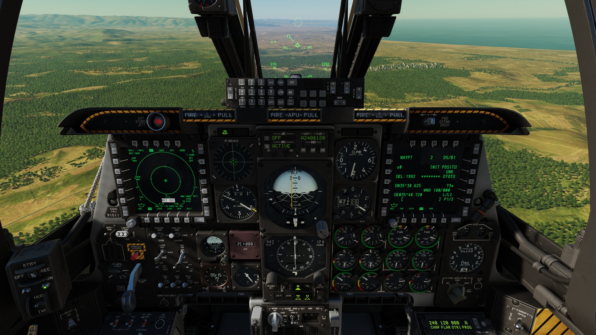
Spawning in grid square KM, you are on the left hand edge of the 38T UTM strip - squares to left (GH, GG and GF) are part of the adjacent 37T UTM strip and not shown/selectable on the AV-8B's ODU. You need to create a waypoint using Lat/Long in the 37T UTM strip and select that, to create/edit UTM co-ordinates in 37T AFAIK this is intended i.e. if you spawn at Kobuleti (37T GG) - KN, KM and KL won't be selectable from the ODU's bottom line.
-
The official manual is still wip (Oct 28th 2021) and doesn't cover weapons or the Gen 3 TPOD The most up to date sources would be Chuck's AV-8B Guide (July 31st 2022) and video's from deephack, etc. made in the last 12 months. Updates are frequent/regular and focused on bug fixing and system fidelity. IIRC next "big" fix that's WIP is to the INS designation logic, etc. All the DCS AV-8B's systems are in and working but have not always been "true" to their RL logic/limitations It's feature complete, AFAIK no more weapons or ECM pods are planned. IIRC most of the included training missions, etc. require updating (to a greater or lesser extent) due to core changes in DCS and/or the AV-8B. • Some older loadouts (i.e. TER mounted rockets) have been removed following SME feedback (so there may be other restrictions planned). • Adding a newer ITER to better reflect 2017 RL loadouts (allows for side by side JDAMs) has been asked for but AFAIK is a low priority compared to improving the OFP H6.2 system modelling. Comment • The largest divergence to RL that I'm aware of is the AV-8B's AWLS landing system that is modelled as an ILS derivative in DCS (rather than ICLS as used by the Hornet, etc). AFAIK Razbam have no plans to change this inaccuracy (SME feedback is that AWLS was rarely used and CASE 3's mostly used a TACAN approach).
-
The Huey's Stabilizer Bar performs a similar function (SME feedback is that ED's Huey is missing this RL stabilization).
-
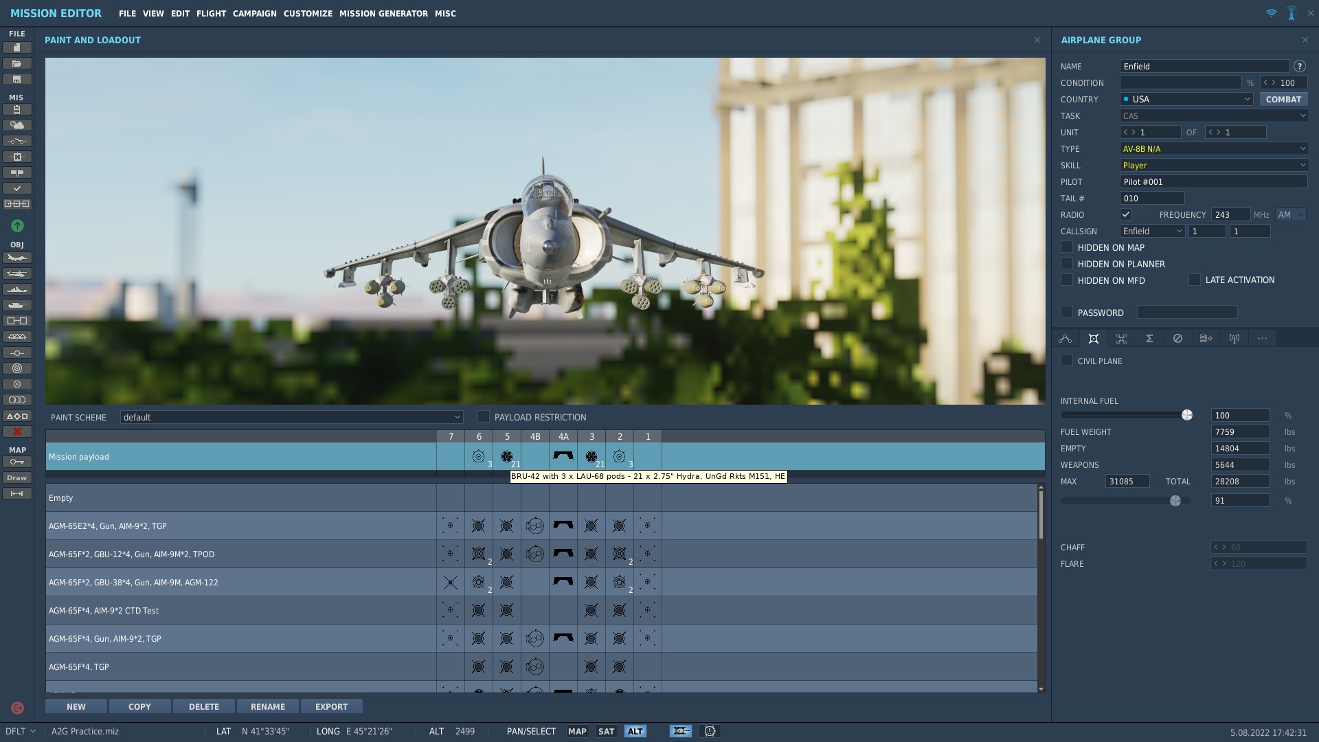
Currently the rocket loadout used by the mission: BRU-42 with 3x LAU-68 Pods (21x 2.75" Hydra with M151 HE warheads) - is invalid, hence why the rockets can't be selected and are listed as 21 ___ on Stores page of the MFD. Unfortunately I don't know what Razbam's intentions are i.e. is the allowed rocket loadout WIP or is the removal of the triple rack BRU-42 intended (and thus requires the old mission(s) to be updated).
-
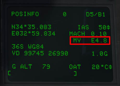
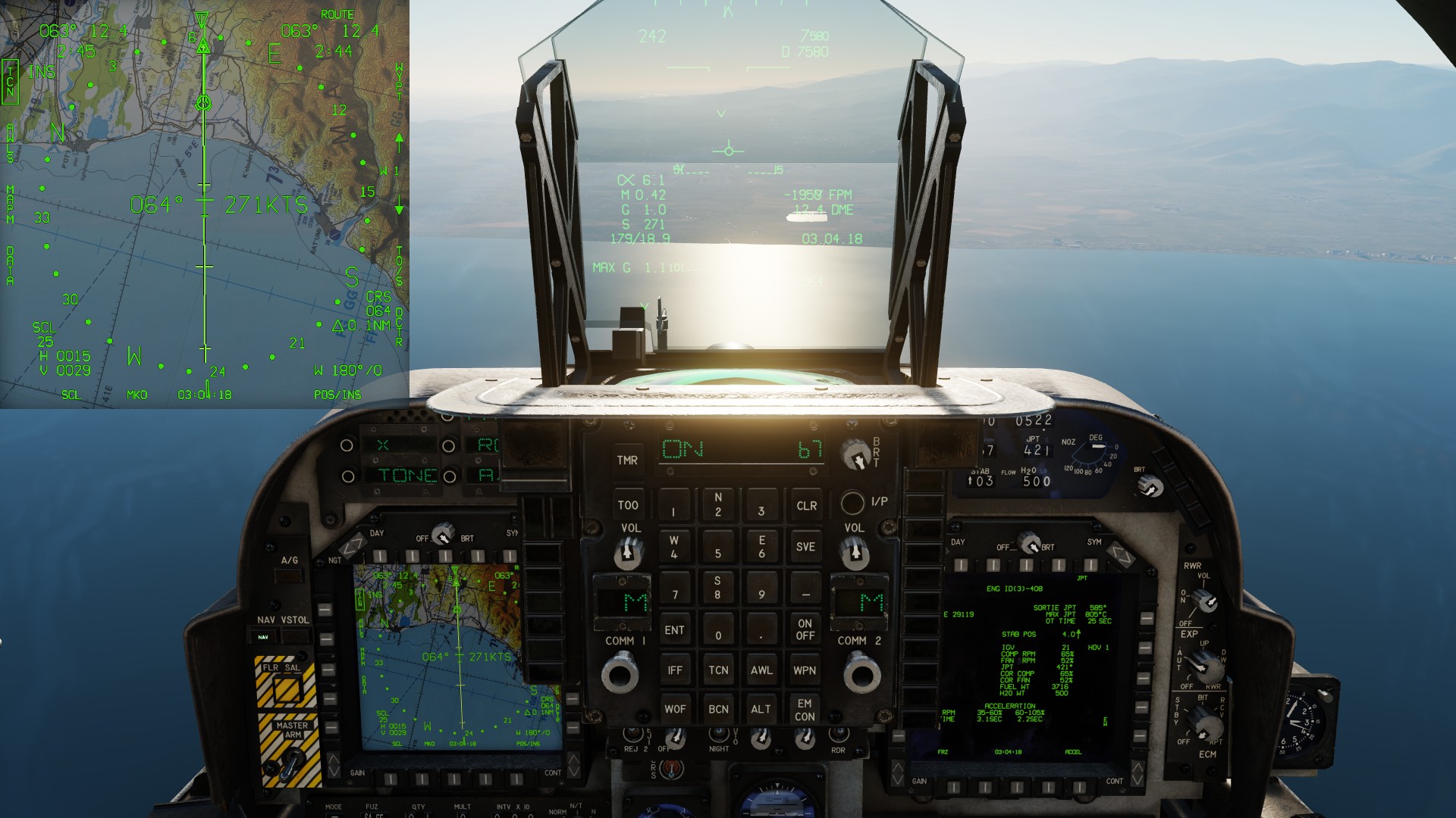
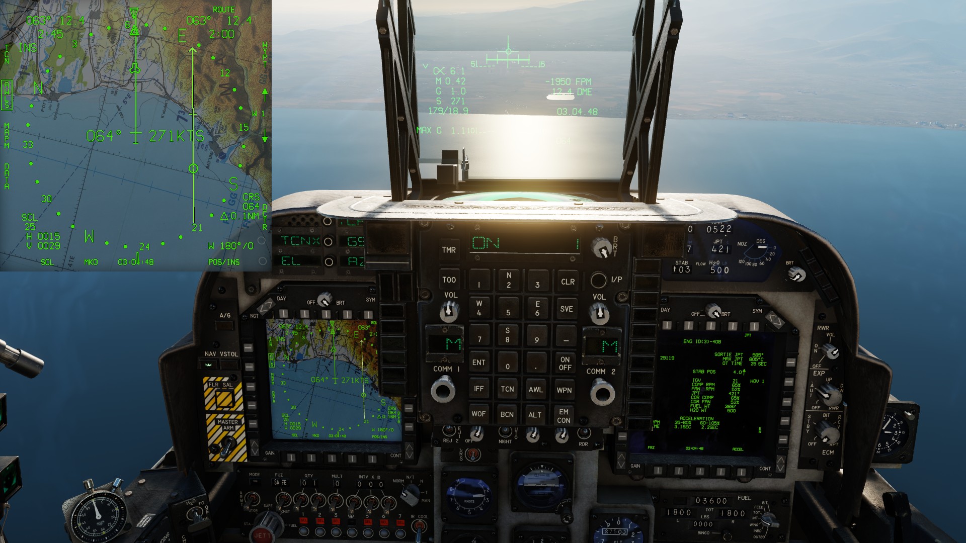
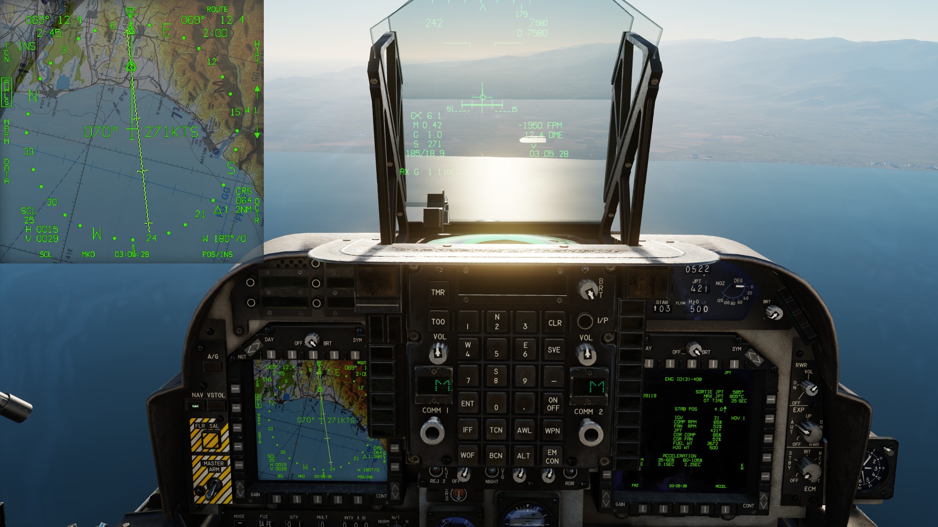
The AWLS TACAN course line isn't co-located with the TACAN beacon on the EHSD when using Magnetic bearings. 1. Selecting TACAN on the EHSD - the course line is correct 2. Selecting AWLS on the EHSD - the TACAN course line/position is misplaced 3. However, changing MAPM to display TRUE bearings fixes this Obviously the TACAN position/course line on the EHSD shouldn't change between pictures 1 and 2. YouTube Video Tested in DCS Open Beta 2.7.16.28157 AV8B EHSD AWLS TACAN course line misplaced when heading set to Magnetic,2_7_16_28157.trk
-
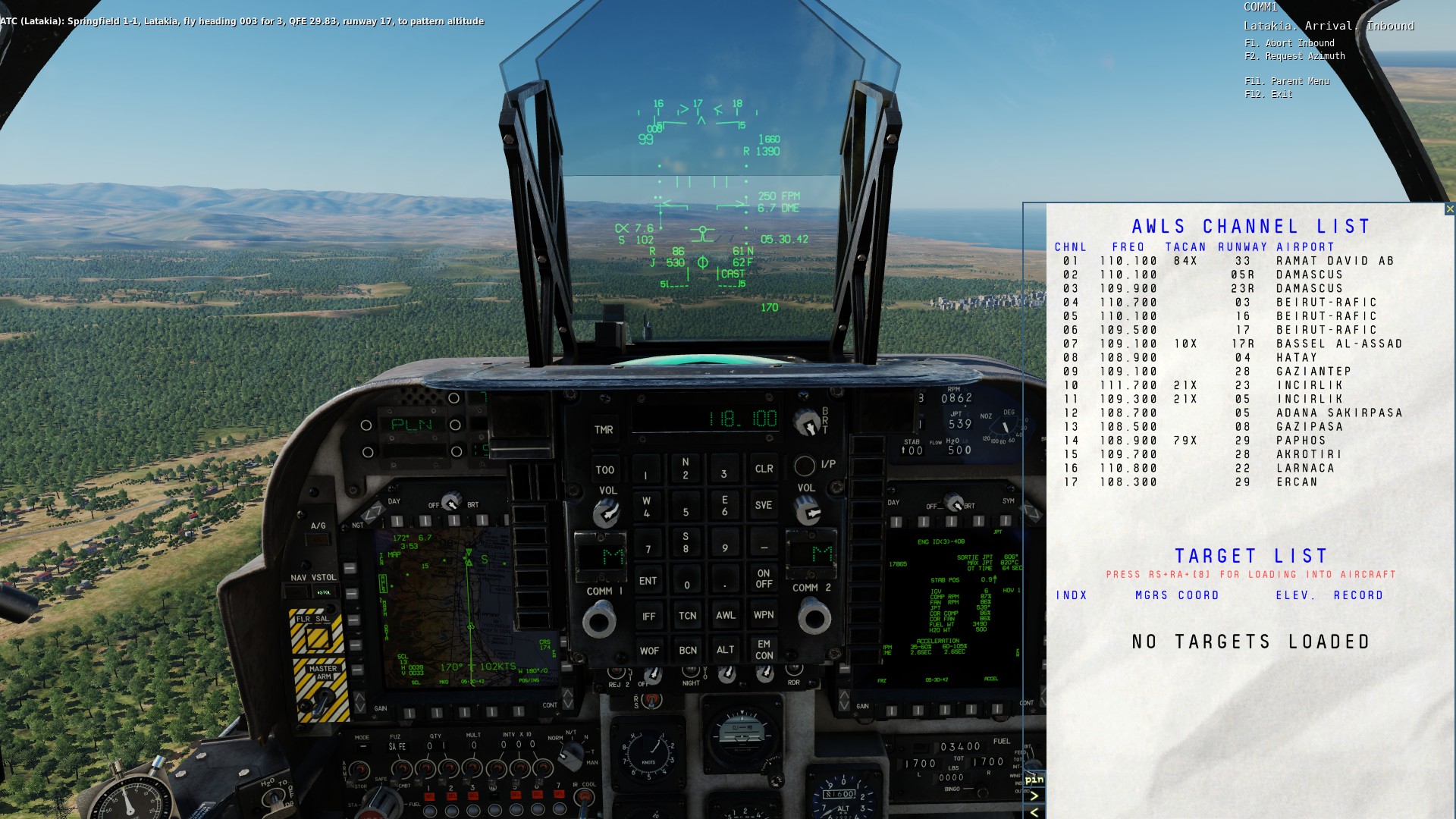
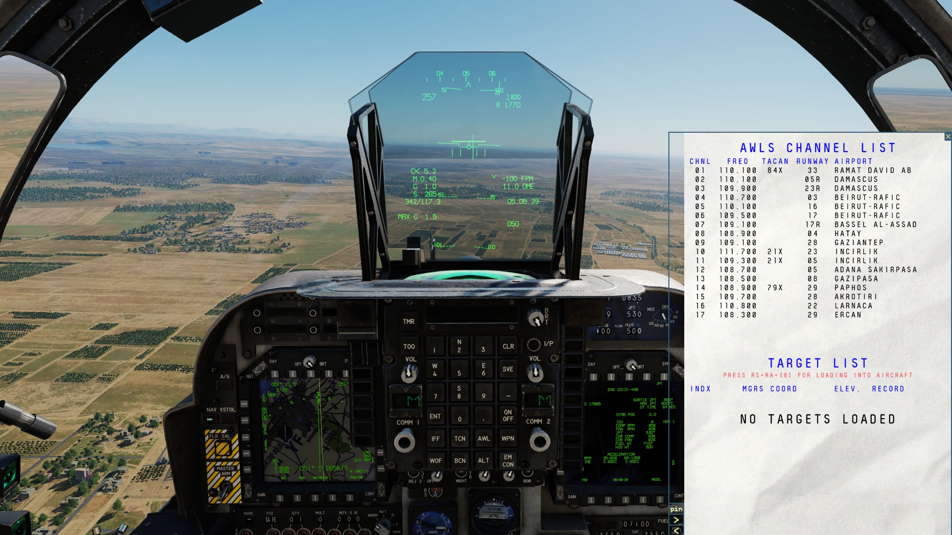
TL;DR: You can't set a mobile tacan beacon to transmit AWLS-ILS for the Harrier. You can only use a map's ILS beacons and the frequencies entered into AN_ARN128_config.lua However you can use the Harrier's ODU to setup the AWLS to use a portable tacan for DME i.e. where an airfield lacks a default TACAN. Detail: Here, when landing at Incirlik RWY 05 AWLS-ILS, I haven't programmed AWLS Channel 07 for Bassel Al-Assad's portable tacan that's using 10X, so the kneeboard shows AWLS channel 07 TACAN as blank. In the other screenshot, I've entered the portable TACAN's channel 10X using the AWLS ODU options, and AWLS DME works. TACAN 10X is associated with AWLS Channel 07, Bassel Al-Assad in the kneeboard. Unfortunately the ILS part (localiser/glide slope) - didn't work when I tested Bassel Al-Assad using the Harrier. Comment IRL AWLS is a microwave landing system and used with an associated TACAN beacon.
-
The Viggen uses the Swedish TILS (Tactical Instrument Landing System), it doesn't make use of the default airfield ILS systems. From Chuck's Viggen Guide AFAIK TILS is a microwave landing system.
-
Yes, it's a limitation of DCS.
-
I'm not sure which airport you are landing at ... Landing East to West • Kutaisi = RWY 25 (248°M / 254°T) • Senaki-Kolkhi = RWY 27 (269°M / 275°T) Neither have ILS when landing East to West and DCS's ATC will turn off the ILS for the opposite directions (RWY 07 / RWY 09). Note there is a long standing DCS 2.x.x bug that desyncs ILS and ATC's active runway for moderate headwinds (1-6 knots) - so to land on RWY 09 using ILS, you'll need to use zero wind or a +6 knot headwind in your mission. Comments/tips The Mirage's Synthetic Runway will not display if the aircraft is not receiving an ILS signal. As both airports have TACAN beacons, you can use DME (300ft/NM) and runway azimuth to penetrate the cloud base. Expanded discussion on Synthetic Runway / Syria https://forum.dcs.world/topic/287989-syntetic-runway/?do=findComment&comment=4836304
-
The AWLS Channels were updated on the 22nd June to support Syria, Mariana Islands and South Atlantic. There's a lot good with the ability to edit the AWLS fields (via the ODU) to support the Portable TACAN Beacon which can be added to airfields that don't have a "native" TACAN. Testing in Open Beta, Incirlik RWY 05 AWLS-ILS worked flawlessly (zero wind), ... unfortunately Bassel Al-Assad RWY 17R did not, and the AV-8B failed to detect Localiser or Glide Slope (the portable TACAN did work). The A-10C had no such issues when testing the ILS and Portable TACAN on Bassel Al-Assad's RWY 17R final. The AV-8B's behaviour at Bassel Al-Assad is similar to what is seen when testing AWLS in Nevada, so perhaps there might be a clue there to get AWLS working in Nevada ? Tested DCS Open Beta 2.7.16.28157
-
Not sure if this is a RL SOP but this is a procedure described by Helljumper as given by a SME Mirage 2000C Break procedure: - 350 kt / 1500 ft initial APP selected on PCA, seat raised. - 60° AoB break, idle and airbrakes. - Slow down until 200 kt. - Maintain 200 kt and close the airbrakes, reduce the bank to 40°. - Once on the downwind, gear down. - When passing the runway threshold, 40° AoB, FPM at -7°. - Once on the last 90° of the turn, look at the runway and adjust pitch and AoB. AFAIK touch down is at 14° AoA Example video using an earlier version of the flight model.
-
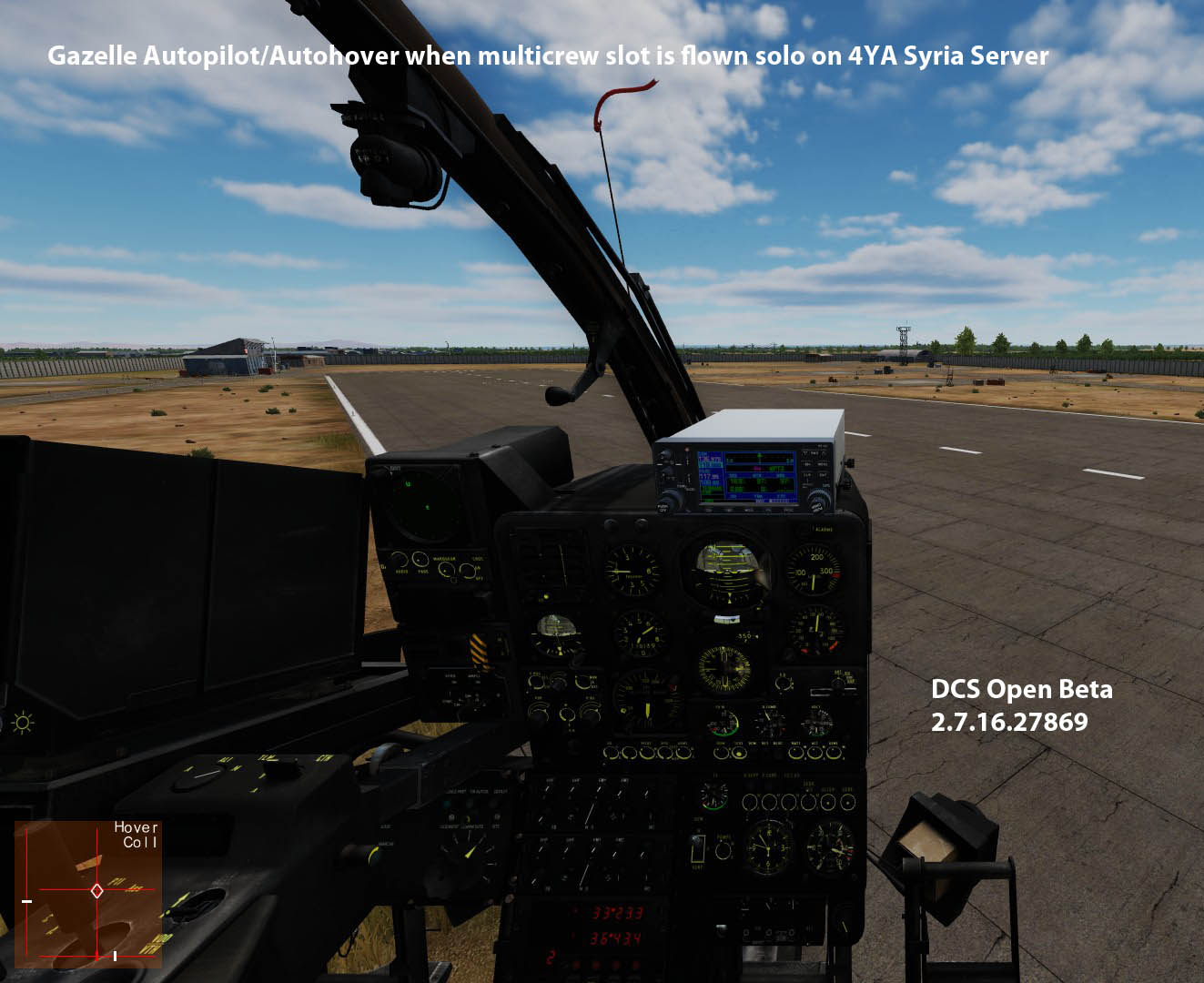
Unlike other modules, the presence of the multicrew slot does not preclude single player operation i.e. this is a multi-crew capable 4YA "slot" when flown solo. As can be seen, the Gazelle autopilot hover allows hands free operation when flown solo. Note that MP behaviour using DCS Stable may be different as IIRC, changes/improvements to multicrew in a previous patch had some unintended consequences.
-
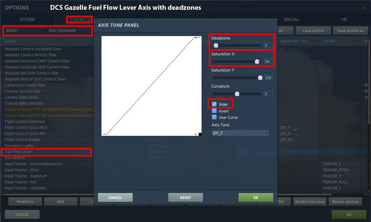
The only way is to set small deadzones at the extremities of the fuel lever's axis travel. This is an example of how to setup an axis for the fuel lever with deadzones
-
Perhaps the Pilot cyclic auto-pilot "master" wasn't on (it's modelled as a toggle in DCS). • Assuming a "normal" cold start with Fuel Control Lever at MAX, gyros ON, SAS Panel Master ON, Pitch/Bank/Yaw SAS channels ON, Mag brake ON, etc. Check the pitch/bank/yaw control monitor "needles" show the SAS is working (needles moving/centered)
-
Steam's 20% discount ends on the 28th July. Pricing/discounts on ED's own store usually last longer i.e. Syria and the Hind, so YMMV.
-
No "Early Access" discount on Steam = no F1 purchase. I can wait, there's plenty more attractive modules due before the end of the year (F-4 and F-15E I'm looking at you).
-
No, but you can round down the JTAC's co-ordinates or add trailing zeros if using precise mode as described by Raptor9
-
[SOLVED] JTAC disappear from menu - AV-8B only
Ramsay replied to vctpil's topic in Problems and Bugs
TL;DR: Initial inspection of your track shows you are testing using an unarmed AV-8B, this is likely why the JTAC menu is not appearing. Note that in the past the DCS JTAC has had issues recognising/dealing with the AV-8B's Gun Pod, so the JTAC "script" would get stuck/fail. With Gun pod removed, the default JTAC and AV-8B integrated pretty well but it's a couple of years since I've tested, so I'll check out a selection of loadouts. Detail: Testing in Open Beta 2.7.15.26783, the gun pod/TPOD combination worked fine with the JTAC "auto mark" WP smoke and the laser mark (although it was sometimes very slow to reply in the radio menu). @vctpil I attach your example mission edited to include both working (apkws, tpod, etc) and gun pod loadouts plus your unarmed AV-8B which can't see/access the F9 JTAC menu. As luck would have it, deephack has made a new tutorial covering using the AV-8B with the default JTAC, which should answer any questions about procedure. AV-8B JTAC Test Updated, Syria, Test JTAC.miz
-
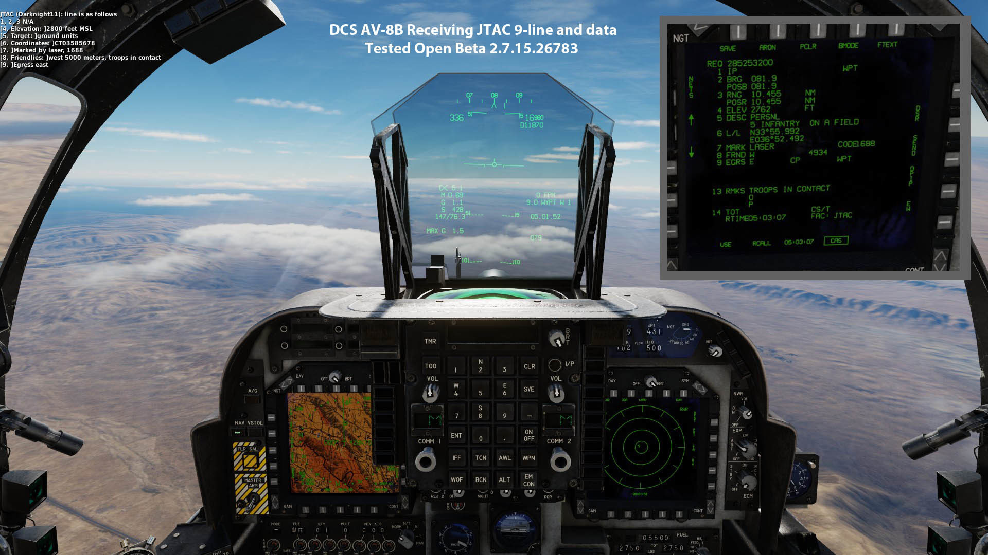
AFAIK the CAS page is filled out after the default DCS IA FAC transmits the 9-line over the radio. The only issue I'm aware of that's been mentioned is the AI FAC doesn't always use the correct Ingress waypoint (haven't tested it myself). Edit: Here's deephack's AV-8B JTAC tutorial describing use of the 9-line in combination with CAS page i.e. how to assign the received coordinate to a target point.
-
CCIP delivery optimum attack profile ( and auto mode question)
Ramsay replied to markturner1960's topic in AV-8B N/A
The original DCS system model (H4.2 ?) was basic but functional, the move to modelling OFP H6.2.1 allowed Razbam to improve the HUD behaviour but made it more nuanced. It's likely getting new weapons (APKWS and GBU-54) and the Gen4 TPOD in took priority. The nuanced behaviours/mode changes are wip and we are waiting for Razbam's updated manual to cover weapon systems/delivery to know which behaviours/limitations are intended and which are not modelled in DCS. As usual with DCS, getting it right is an iterative process (three steps forward, one step back) and a question of priorities. -
Already reported/acknowledged, not sure of it's priority WR to other issues/features. This is AV-8B Harrier forum, the aim point should be where the bomb stick is centered (not where it starts).
-
CCIP delivery optimum attack profile ( and auto mode question)
Ramsay replied to markturner1960's topic in AV-8B N/A
The only TAC manual available via the internet is from 2003, so is missing many details (AFAIK Razbam are relying on SME feedback to model OFP H6.2.1). With that said, this my current understanding 1. Unfortunately I haven't worked through in detail the conditions and parameters require to enable the different modes in DCS i.e. Auto, CCIP, RCIP, GCIP, etc. 2. One of the elements of the "bombing triangle" used to calculate the impact point is the aircraft's height above the target. The order of aircraft altitude source accuracy is RAlt, GPS and then Barometric. • RAlt only works below 5,000 ft but may not be the "best" if the terrain below the aircraft is not at a similar altitude to the target • GPS is subject to jamming or loss of satellite tracking and has an error margin of +/-10m IRL (1993 Test results?). AFAIK DCS treats GPS Alt as perfect. • Baro is subject to pressure changes and requires a QNH estimate for the target area (Note IRL the AV-8B uses the selected Waypoint/Target Point altitude as "target altitude", AFAIK DCS simplifies this). Hence why you might want to select all 3 3. The ARBS uses DMT TV or LST tracking to measure target "Angle" and "Angle Rate" to calculate the slant range* i.e. the DMT needs to be locked on the target using the TV contrast lock or Laser Spot Track. The TPOD uses similar "Angle Rate" tracking but has the advange it can "directly" measure slant range using it's laser - so should be as accurate as the DMT if not more so. *Note calculating the slant range using "Angle Rate" requires also knowing your altitude above the target point. The final bombing "solution" uses the INS (gyros and accelerometers) to measure the aircraft's ground speed and direction, so is "wind corrected" in so much as how wind effects the aircraft.