Balion
-
Posts
62 -
Joined
-
Last visited
Content Type
Profiles
Forums
Events
Everything posted by Balion
-
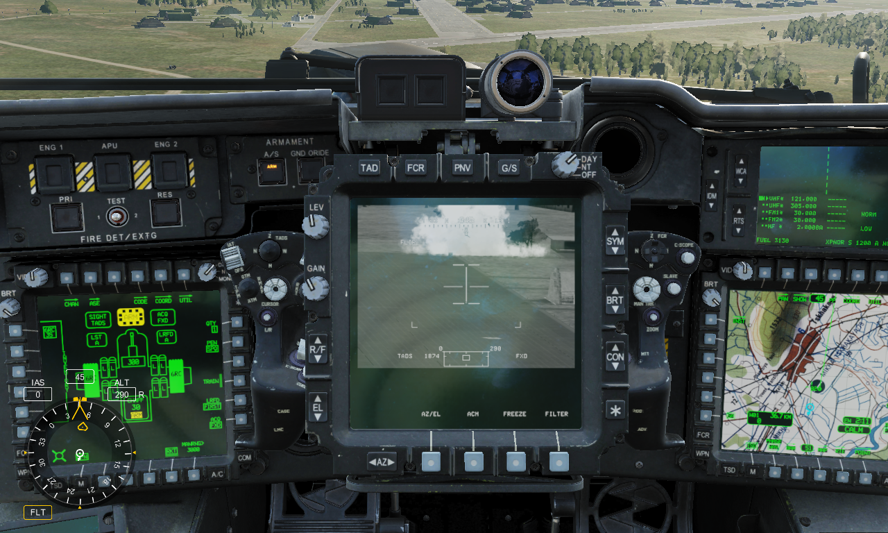
When aiming by TADS with laser-ranging, rockets are usually falling long. This applies to COOP mode with George also. rockets tads.trk

-
Running DCS server disables TrackIR
Balion replied to wowbagger's topic in PC Hardware and Related Software
When TrackIR stops working in DCS, go to "Controls" menu and click "Rescan devices". -
У меня работают. Попробовал с ФАБ-500 на 1-2 точках.
-
С какой высоты пускаешь? AGM-84 никогда не набирает высоту после пуска.
-
Она не показывается, пока не сделан built-in test на странице Bit -> Displays -> HMD.
-
Try "Request aircraft control" command and then activate menu.
- 2 replies
-
- 1
-

-
- settings
- front seat
- (and 3 more)
-
Minor issue -please remove C-17 AI traffic .
Balion replied to Snappy's topic in F-14A Zone 5 Campaign
If you delete their main task ("Tanker" or "AWACS") they shouldn't do that. -
When i had this problem, it was because of joystick miscalibration (lateral axis not centered).
-
Deleted all files in "bin" except updater and run repair. Initialization error now gone. Seems like some files got corrupted.
-
I get this error on DCS.exe launch (openbeta 2.7.0.5659). No log files are generated. It was working ok some days ago. I've run "dcs_updater cleanup", "dcs_updater repair", updated Nvidia drivers, DirectX, VC Runtime libraries, run "sfc /scannow". No luck. DxDiag.txt
-
Create a .lua file in folder "Saved Games\DCS\Scripts\Hooks" with contents: myscript = {} function myscript.onMissionLoadEnd() net.dostring_in("mission", "a_do_script(\"loadfile(\\\"D:/myscript.lua\\\")()\");") end DCS.setUserCallbacks(myscript) Script "D:\myscript.lua" will run on each mission start.
-
Here is a function which sets true heading and speed for a unit: local carrier = Unit.getByName("Naval-1-1") local function headTo(unitDCS, trueHeadingDegrees, speedMetersPerSecond, timeSeconds) local distance = timeSeconds * speedMetersPerSecond local delta = { z = distance * math.sin(trueHeadingDegrees * math.pi / 180), x = distance * math.cos(trueHeadingDegrees * math.pi / 180), } local position = unitDCS:getPoint() -- env.info(string.format("p x: %d, p z: %d", position.x, position.z)) -- env.info(string.format("d x: %d, d z: %d", delta.x, delta.z)) local Mission = { id = 'Mission', params = { ["route"] = { ["points"] = { [1] = { ["alt"] = -0, ["type"] = "Turning Point", ["ETA"] = 0, ["alt_type"] = "BARO", ["formation_template"] = "", ["y"] = position.z + delta.z, ["x"] = position.x + delta.x, ["ETA_locked"] = true, ["speed"] = speedMetersPerSecond, ["action"] = "Turning Point", ["task"] = { ["id"] = "ComboTask", ["params"] = { ["tasks"] = { }, -- end of ["tasks"] }, -- end of ["params"] }, -- end of ["task"] ["speed_locked"] = true, }, -- end of [1] }, -- end of ["points"] }, -- end of ["route"] } } unitDCS:getController():pushTask(Mission) end headTo(carrier, 100, 10, 600) -- set true heading 100 degrees and speed 10 m/s for 600 seconds. After 600 seconds carrier will stop.
-
local carrier = Unit.getByName("Naval-1-1") local ActivateBeacon = { id = 'ActivateBeacon', params = { ["type"] = 4, ["AA"] = false, ["unitId"] = carrier:getID(), ["modeChannel"] = "X", ["channel"] = 1, ["system"] = 3, ["callsign"] = "CVN", ["bearing"] = true, ["frequency"] = 962000000 } } carrier:getController():setCommand(ActivateBeacon) local ActivateICLS = { ["id"] = "ActivateICLS", ["params"] = { ["type"] = 131584, ["channel"] = 1, ["unitId"] = carrier:getID(), }, -- end of ["params"] } carrier:getController():setCommand(ActivateICLS) local SetFrequency = { id = 'SetFrequency', params = { frequency = 126300000, modulation = 0, } } carrier:getController():setCommand(SetFrequency) local tanker = Unit.getByName("Aerial-2-1") local ActivateBeacon = { id = 'ActivateBeacon', params = { ["type"] = 4, ["AA"] = true, ["unitId"] = tanker:getID(), ["modeChannel"] = "Y", ["channel"] = 10, ["system"] = 4, ["callsign"] = "TKR", ["bearing"] = true, ["frequency"] = 1097000000, } } tanker:getController():setCommand(ActivateBeacon) local SetFrequency = { id = 'SetFrequency', params = { frequency = 256000000, modulation = 0, } } tanker:getController():setCommand(SetFrequency) local Tanker = { id = 'Tanker', params = { } } tanker:getController():pushTask(Tanker) You need to assign a new route to supercarrier or fleet unit. See next post. All info i've got from https://wiki.hoggitworld.com/view/Simulator_Scripting_Engine_Documentation and from "mission" file inside ".miz" archive when you first try to do something in mission editor before creating a script.
-
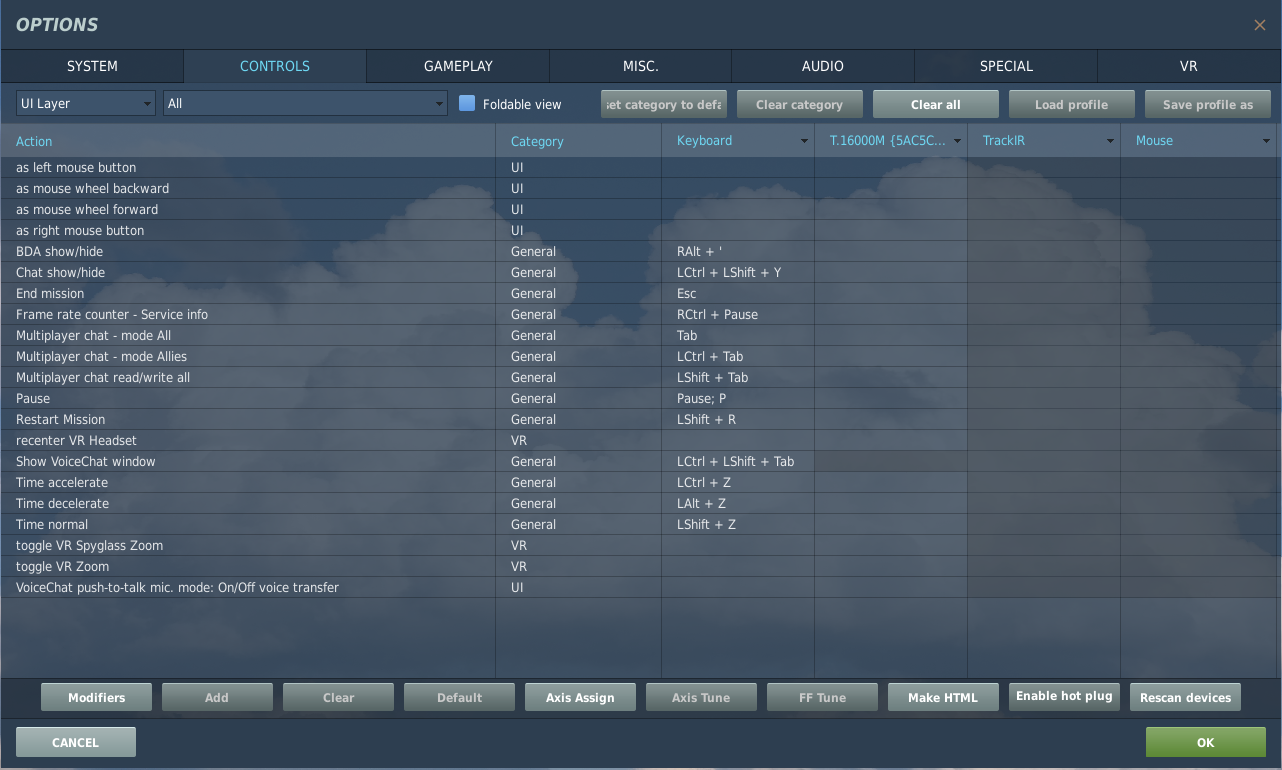
correct as is Time Acceleration missing after 2.7.0.5659 ?
Balion replied to DimSim's topic in Controller Questions and Bugs
They moved some actions from aircraft-specific sections to "UI Layer".
-
[NO BUG] EHSD page is blank in INS NAV and IFA modes
Balion replied to Balion's topic in Resolved Bugs
I have reinstalled AV-8B module, EHSD now works ok. Looks like some file was missing or corrupt. This topic may be closed. Good luck all \0/ -
[NO BUG] EHSD page is blank in INS NAV and IFA modes
Balion replied to Balion's topic in Resolved Bugs
VRAM usage is 2GB, but adjusting DCS settings is problematic because almost all settings are already on lowest option. I don't think my issue is VRAM related: selecting INS to ALIGN shows EHSD page. Also i have no graphic issues with other modules. After updating DCS to 2.7.0.5659 and NVIDIA driver to 466.27 the issue is still there -
[NO BUG] EHSD page is blank in INS NAV and IFA modes
Balion replied to Balion's topic in Resolved Bugs
"metashaders2" is empty. I have cleaned "fxo" and also run dcs repair. No luck. Specs in spoiler, options and log file in attached file dcs_options.zip -
ehsd.trk
-
Для этого надо запустить команду DCS_updater.exe update @openbeta из каталога bin в папке DCS World. Или воспользоваться этой утилитой. Выше ответы неверны.
-
Умеет.
-
investigating Bombing altimeter (MPC) incorrectly modelled?
Balion replied to scoobie's topic in Bugs and Problems
You can't reference pressure altitude on map, because it depends on current atmospheric pressure (QNH). Look at the picture (http://www.faatest.com/books/IFRH/4-0.htm) You can obtain target pressure altitude (PA) from target elevation (ASL) via altitude correction (AC): PA = ASL - AC, where AC = ~1000 ft per each 1 inHg QNH above 29.92. For example, if ASL = 1500 ft, QNH = 30.42 inHg, then AC = 500 ft, PA = 1500 - 500 = 1000 ft. -
investigating Bombing altimeter (MPC) incorrectly modelled?
Balion replied to scoobie's topic in Bugs and Problems
I have one more question to add. You can see PRESSURE ALTITUDE label on the altimeter scale. That means the bombing altimeter doesn't indicate above sea level altitude, but pressure altitude. So the target altitude pointer should be also dialed to target pressure altitude, not above sea level altitude as manual says. Thats add another complexity for pilot. Why he just don't use main altimeter for bombing as in some other aircraft? -
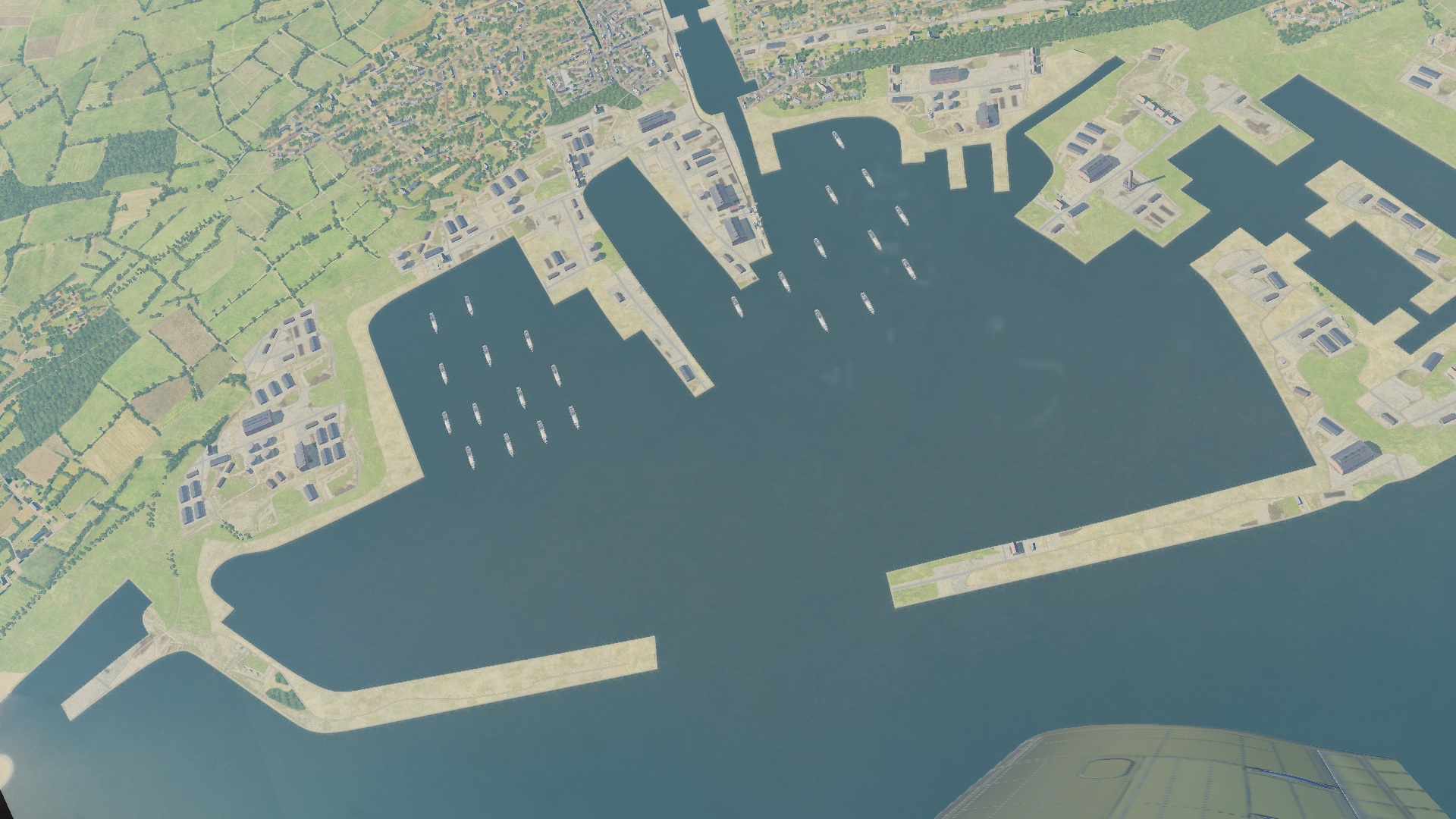
Ships placed near pier in Cherbourg harbour aren't visible on lower zoom levels. Attach: 1.jpg - lower zoom, 2.jpg - higher zoom. cherbourg.trk
-
forum search & barometric pressure setting limited to 28.10
Balion replied to fitness88's topic in DCS: F/A-18C
Strictly speaking it doesn't equal to 1 inHg per each 1000 ft even in standard conditions. It's just an approximation for fast math. Actual formula is more complex: https://en.m.wikipedia.org/wiki/Barometric_formula (for humidity = 0%). -
All major airports in Russia have ICAO standard ILS systems. See AIP Russia: http://www.caiga.ru/common/AirInter/validaip/aip/gen/gen2/1-gen2-5.pdf