drPhibes
-
Posts
1182 -
Joined
-
Last visited
-
Days Won
2
Content Type
Profiles
Forums
Events
Everything posted by drPhibes
-
Like the combat aircraft we are pretending to fly in DCS?
-
https://www.amazon.com/How-Talk-Your-About-Safety/dp/045149492X
-
M11/P228
-
I used to have a P226 SL (steel frame) that I shot in IPSC production, but I sold it a few years ago. For some reason I never really liked it. I actually prefer the G19 gen4 for that use. My current SIG lineup; a German P210 Super Target and a US 1911 Traditional Match 9mm.
-
https://en.wikipedia.org/wiki/Adobe_After_Effects https://www.youtube.com/user/CaptainDisillusion/videos
-
article in this months PC pilot is concerning
drPhibes replied to Cowboy10uk's topic in DCS: F-14A & B
Expecting print media to give up-to-date informtion is a bit optimistic. -
-
My guess would be that you know absolutely nothing about the contracts and agreements between ED and the 3rd party developers, and that your assumptions are based on a statistically insiginificant number of released modules. Leave announcements like release dates etc to the official sources. Spreading runours is counter-productive and benefits nobody.
-
Do you have any official information (either from ED directly, or a 3rd party dev.) to back this up? Or are you just repeating what someone on the internet said?
-
Nobody said it would be possible. Unless someone has been living under a rock since 1979, it should be pretty obvious to everyone that it isn't a viable option.
-
If they wanted a flyable F-14 they'd have to rent one from Iran...
-
Syrian and Afghan theatre of operations confirmed!
drPhibes replied to WHOGX5's topic in Bugs and Problems
ED hasn't said anything, but Wags has posted screenshots showing Ramat David, Beirut and Incirlik. Other than that, we have Ugra-media's development screenshots and project description from their website. -
For some reason, I believe more in ED's claim that from the January 4th newsletter than the opinion of a random person on the internet. TL;DR: unless you can prove otherwise, your "humble opinion" is worthless.
-
Try reinstalling the .NET framework from Microsoft. https://dotnet.microsoft.com/download/dotnet-framework-runtime/net472
-
Do individual weapons/stores add to the overall RCS in DCS
drPhibes replied to Knock-Knock's topic in DCS 2.9
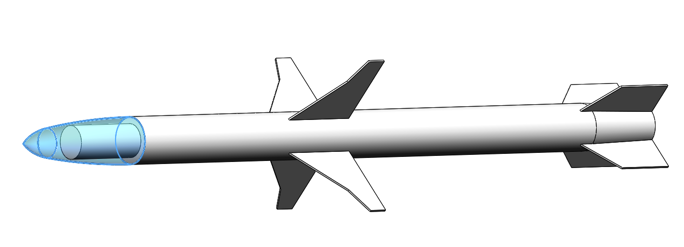
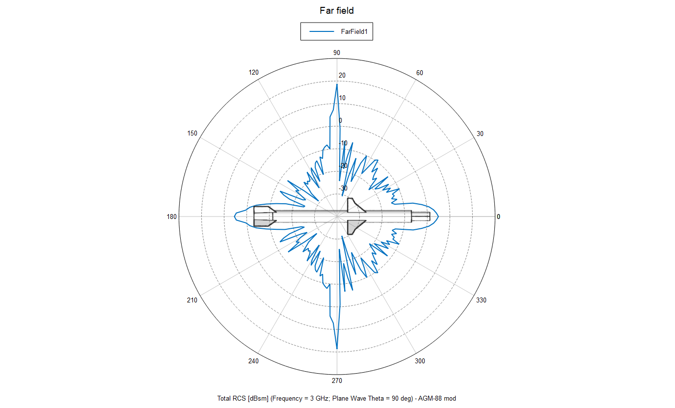
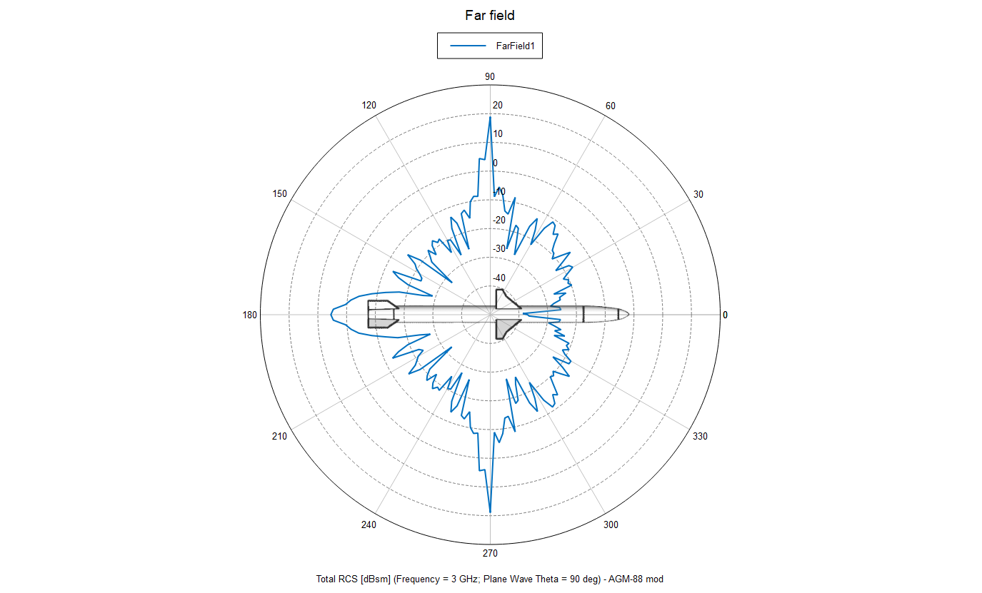
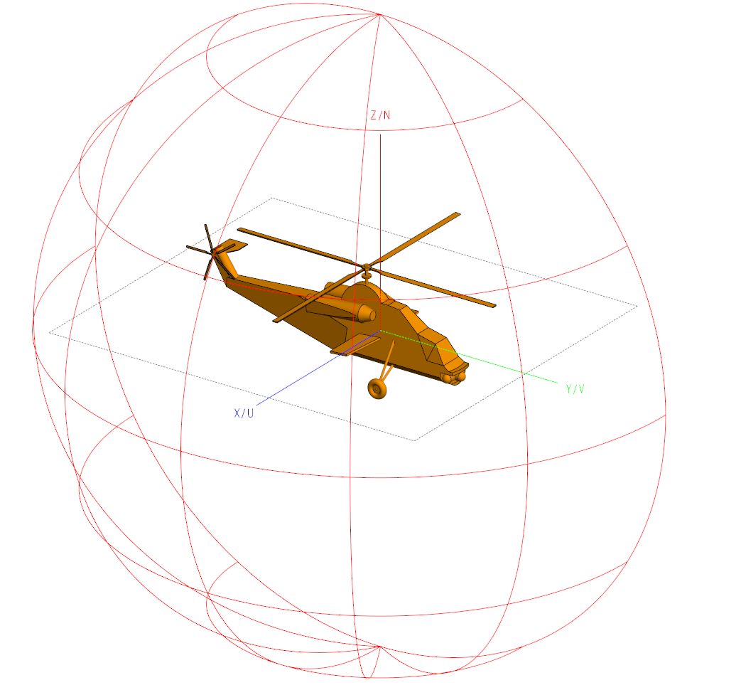
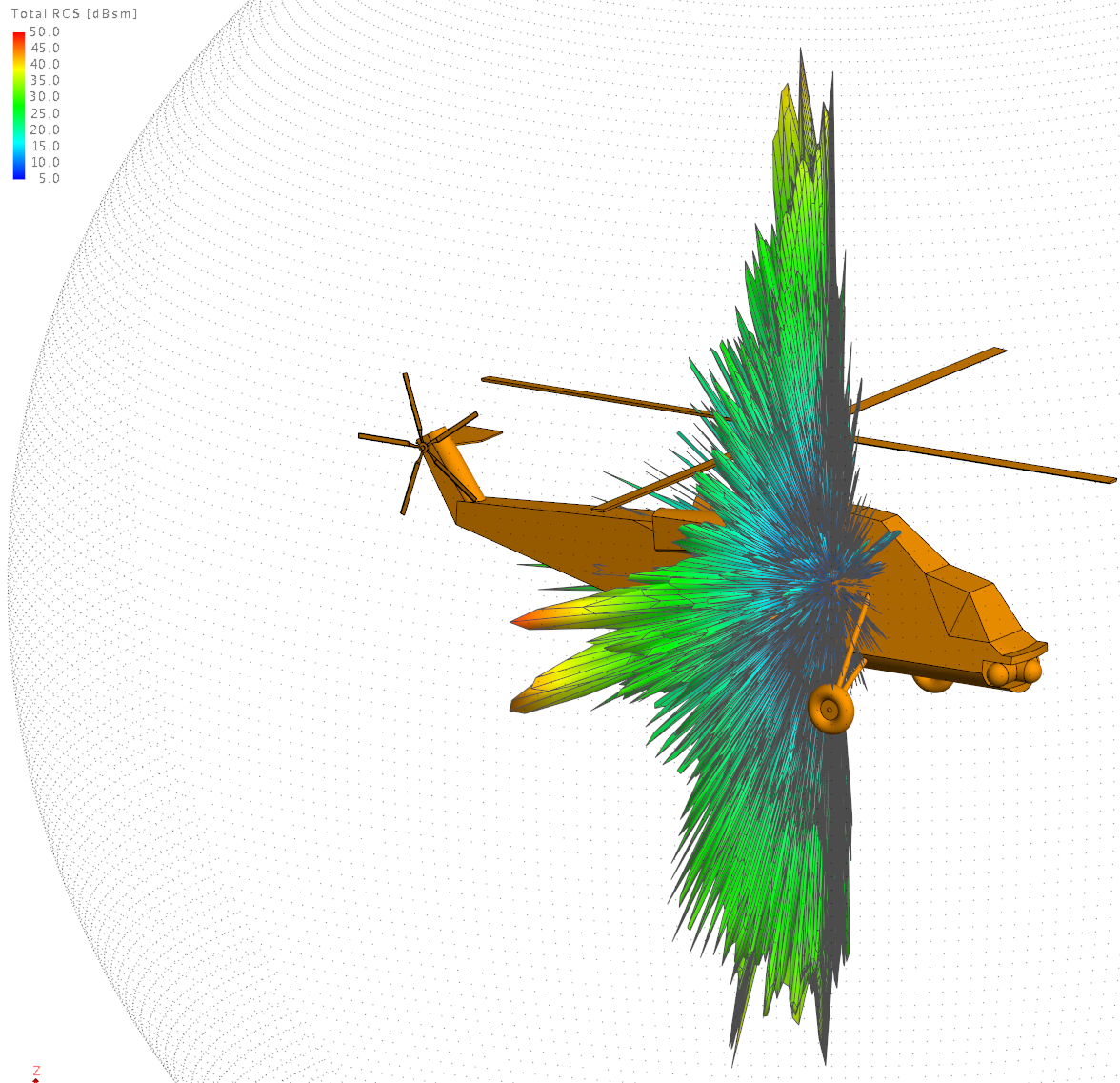
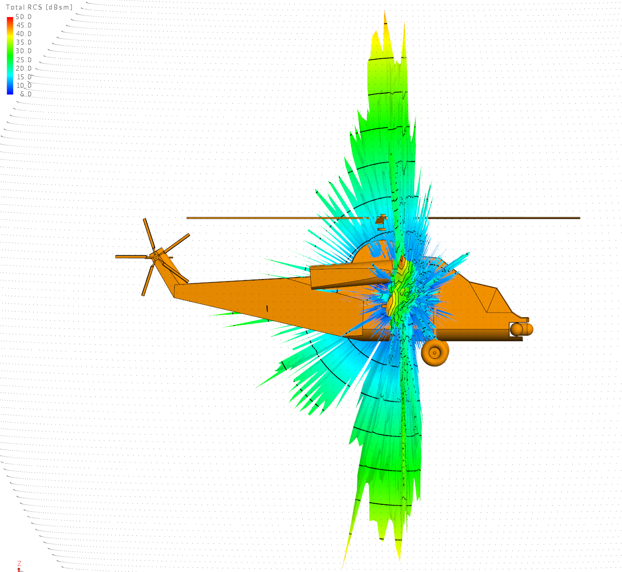
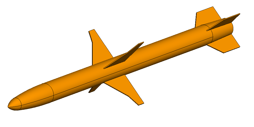
I made a few changes to my HARM model. There aren't many (or any) good sources of info on what the antenna under the radome acturlly looks like, but there is a low detail drawing from Raytheon floating around that shows a configuration with a conical log spiral antenna (which seems plausible, given the ultra wideband nature of the 88's seeker). I simplified it (a lot) by just modelling the whole seeker electronics and antenna section as a simple extruded cylinder. I excluded the radome from the simulation (messing around with dielectric media increases the processing time too much), and the result was, as expected, quite different from the previous "metallic radome" test: I have also played around a bit with one of the example models included with the training material; a Denel Rooivalk! The plan was to get a simple 3d rcs pattern of the right hemisphere (at 1° steps), but I had to cut the simulation short after 3,5 hours (85%), so the frontal aspect of the "blob" is missing. The material is a perfect electric conductor, and the frequency is 1GHz (linearly polarized). RCS varies with material, frequency, polarization and aspect ratio, so none of these walues can be claimed to be correct, as there are too many variables to take into account.
-
\DCS World\bin\dcs.exe (or dcs_updater.exe, which launches the game if no new updates are available)
-
Do individual weapons/stores add to the overall RCS in DCS
drPhibes replied to Knock-Knock's topic in DCS 2.9
The run time wasn't as bad as I expected compared to my previous experiments with RCS. I can't remember exactly, but i think it was around 30 minutes, with a coarse mesh, 2° steps in φ, using the physical optics solver (with a different computer than the workstation described earlier). I haven't done any other simulation than the one in the horizontal plane yet, but it is on my to-do-list. -
WOW! When did we get new SU-34? It looks amazing.
drPhibes replied to DmitriKozlowsky's topic in DCS 2.9
Wiki says lots of things. Like that the AV-8B+ can carry AGM-88 or 84s, which it can't. There's not really much space for a rear facing radar underneath and/or behind the APU exhaust: -
Boeing pitching the F-15 to Germany
drPhibes replied to Hummingbird's topic in Military and Aviation
And the UK is not part of the US/NATO nuke sharing programme, so there is no need for B61 capability or UK Typhoons. The Royal navy Trident II SLBMs are the only nuclear weapons in the UK arsenal at the moment. -
Do individual weapons/stores add to the overall RCS in DCS
drPhibes replied to Knock-Knock's topic in DCS 2.9
Altair FEKO. -
Do individual weapons/stores add to the overall RCS in DCS
drPhibes replied to Knock-Knock's topic in DCS 2.9
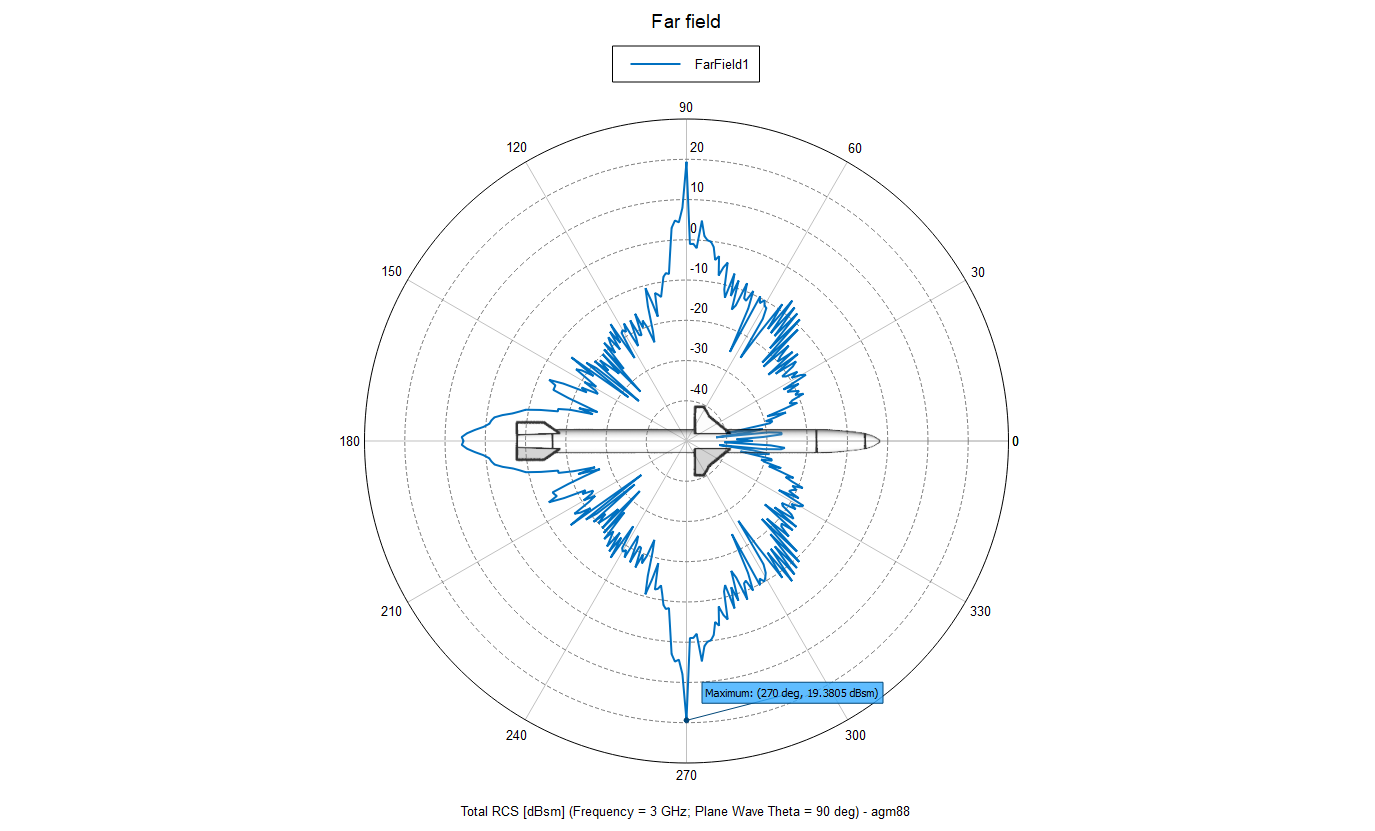
This topic triggered my curiosity a bit, so I made a crude model of the AGM-88 and ran a simple monostatic RCS simulation at 3GHz (S-band) in the horizontal plane (θ = 90°, φ = 0-360°). The front aspect (φ = 0°) is clearly wrong since the whole missile is simulated as a perfect electric conductor, while the real missile has a dielectric radome and an antenna inside. The actual φ = 0° result would probably be more like the rear aspect (φ = 180°).
-
PSA: the book "System 37 Viggen" is now available online as PDF
drPhibes replied to renhanxue's topic in DCS: AJS37 Viggen
-
Razbam are focusing on other projects. The OV-10 is a personal project of one of the new devs:
-
Looks great. Keep up the good work!
-
Here's a brief explanation: