drPhibes
-
Posts
1182 -
Joined
-
Last visited
-
Days Won
2
Content Type
Profiles
Forums
Events
Everything posted by drPhibes
-
Developer jailed in US for smuggling F-16 manuals
drPhibes replied to RaceFuel85's topic in Chit-Chat
"Engineer's syndrome", a.k.a. curiosity? I read lots of technical stuff that I'll never use for anything. Can anyone here say that they wouldn't like to read the manuals for the 22/35 if they had the chance? -
Developer jailed in US for smuggling F-16 manuals
drPhibes replied to RaceFuel85's topic in Chit-Chat
Can someone post screenshots of the article? It can't be accessed from Europe (thanks a lot GDPR....) -
https://forums.eagle.ru/showpost.php?p=3285514&postcount=13
-
[FREEZE FIXED INTERNALLY] JDAM Feedback thread
drPhibes replied to NineLine's topic in Bugs and Problems
Unboxing a JDAM in the stores page cuts all power, and since it doesn't have any static memory for storing GPS and INS parameters, a full transfer alignment must be performed when re-selecting the JDAM. Storing this data in non-volatile memory is a bad idea for a few reasons: 1. INS data would be completely unusable after a short time unless you are flying straight and level at at constant velocity. If the alignment quality is insufficient you will need to perform a full JDAM transfer alignment to rectify this. 2. Storing the keys for the P(y) GPS signal in a form where they may theoretically be recovered from UXO or fragments of the guidance unit is most likely something that the US DoD isn't particularly fond of. -
It doesn't normally take anywhere near 10 minutes. The counter counts down from 10 minutes, but optimal transfer alignment is normally reached after 2 minutes and 30 seconds (7:30 on the counter).
-
The JDAMS have no static memory. When power is disconnected (by unboxing the JDAM in the stores page), GPS ephemeris data (orbital data for the satellites in view), GPS crypto keys (necessary when using the P-code, so N/A for us DCSers), target data and transfer alignment (which aligns the JDAMs IMU to the one in the plane) is lost. When re-powering the JDAM, the transfer of GPS parameters and IMU alignment restarts.
-
It could depend on the avionics in the aircraft. Most civilian nav radios will automatically tune the DME receiver to the correct channel when selecting a LOC/VOR frequency, but this may noe be the case in the M2000.
-
I have made a spreadsheet that converts between DDMM.mmm, Lat Lon Decimal in the DCS settings, (which is accurate enough to hit a tank at an arbitrary position) and DDMMSS.ss. See the attached file. I made it in OpenOffice Calc, but I assume that it is fully Excel-copmpatible. Edit: 0.001 arc min = 0.06 arc sec, so Lat Lon decimal + the conversion in the spreadsheet is accurate to approximately 1,5m. coordinate conversion.zip
-
Just as a note, beamwidth typically refers to the half power (-3dB) width of the main lobe. The lobe extends beyond this. Exactly how much depends on the antenna design. Here's an illustration that shows the principle:
-
This is correct (although technically speaking, most modern gyroscopes for aerospace use are based on the principle of Sagnac interferometry, not conservation of angular momentum). I was merely pointing out that there is acceleration involved when you have a constant angular velocity. The centripetal acceleration is largely negligible, being an order of magnitude lower than the local variations in gravitational acceleration.
-
Because ED are upgrading the system modelling for the JDAM quite a bit compared to what is currently present in the A-10C. Implementing a comparably sub-standard version from the A-10C and then changing it, potentially re-doing large parts of the avionics modelling, when the improved version is ready makes little sense.
-
The difference is that with the Harrier nozzles fully aft your net force at maximum thrust is still upwards, with a small rearward component.
-
Updating updates all modules you have installed. If you temporarily move the maps the updater will just download all the missing files in addition to the ones affected by the update.
-
Tangential movement along a circular path results in centripetal acceleration.
-
and the Panavia Tornado.
-
Looks great. I have put my IRIAF skin projects (splinter and the blue/grey camo) on the back burner until the templates are released. Which font are you using for the tail number? And which color codes are you using for the camo? I would like my liveries to match the skins made by other users a little better than my F-5 skin (the pale one in the back: https://i28.servimg.com/u/f28/11/46/94/48/screen14.jpg ).
-
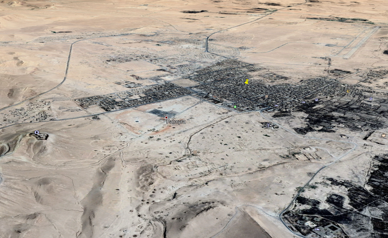
Syrian and Afghan theatre of operations confirmed!
drPhibes replied to WHOGX5's topic in Bugs and Problems
It has to be Palmyra. The airport looks a bit off (it could be early WIP after all), but the layout of the city and the temple ruins in the foreground gives it away:
-
Syrian and Afghan theatre of operations confirmed!
drPhibes replied to WHOGX5's topic in Bugs and Problems
It doesn't look like Aleppo. The apron on the airport in the screenshot isn't part of the actual airport, and the whole terminal area (from a screenshot a few pages back) is missing from this screenshot. -
Syrian and Afghan theatre of operations confirmed!
drPhibes replied to WHOGX5's topic in Bugs and Problems
Has anyone figured out where this is yet? The apron in the lower left of the airport and the runway with a parallel taxyway with RETs looks a bit like Tabqa airbase, but the city doesn't fit in. -
Syrian and Afghan theatre of operations confirmed!
drPhibes replied to WHOGX5's topic in Bugs and Problems
Already posted: https://forums.eagle.ru/showpost.php?p=3760179&postcount=209 -
If google translate is to be trusted (100.000 Chinese user manuals can't be wrong... Or can they?) the phenomenon we are dealing with here is a 트롤.
-
Read the EULA. Neither DCS or any of the modules are your property. You are given a license to use the software, but you do not own it.
-
Where to find ADF frequency of Airbase in Mission Editor?
drPhibes replied to GrEaSeLiTeNiN's topic in DCS: F/A-18C
The F-18 uses the comm radio for ADF, so none of the NDBs in the various maps are useable. You'll have to tune it to a VOR frequency. -
Since the meridians meet at the poles, the distance covered by one arc second of longitude changes depending on where on earth you are. At the equator, one arc minute is one nautical mile = 1852m, so 1 second = 30,86m. The parallels (circles of lattitude) are equally spaced, so one sec north or south equals the same distance everywhere. 1 arc second of longitude = 20m in Normandy 27,8m in the Persian Gulf 24m in Nevada
-
Read the article...