=475FG= Dawger
-
Posts
1933 -
Joined
-
Last visited
-
Days Won
1
Content Type
Profiles
Forums
Events
Everything posted by =475FG= Dawger
-
In certain conditions, negative G will cause the engine(s) to flameout.
-

Roll Input structural failure modeling is incorrect.
=475FG= Dawger replied to =475FG= Dawger's topic in Bugs and Problems
If we were flying fatigued aircraft, this would be relevant. However, we aren't except for the F-5 apparently. I do not disagree that pulling an excessive amount of G force would damage the airframe permanently and would contribute to premature failure at some point in the future. Metal fatigue is a thing. Metal fatigue occurs over many cycles. It is difficult to break metal in a single cycle. Single event catastrophic failure is generally not a thing with airplanes unless they were previously damaged. So if we are being issued an old, worn out F-5 that hasn't been subject to fatigue inspections, then yes, catastrophic failure from a single event should be possible. However, if the assumption is that the jet is fresh off the production line, it should be difficult to snap the wings off on the first go. Again, why are only a few modules given this treatment? If this is the most realistic treatment of structural failure, why isn't applied to every module? -
I did not say I got it from the DCS manual. What I quoted was from the F-5 Technical Order 1F-5E-1-1984. However, the answer to your question is in your own post. Another ARN-118 is not an airborne TACAN station. TACAN bearing equipment is generally too large to be installed on a fighter.
-
It (the manual for the F-5) actually says the 118 only provides bearing to specifically equipped cooperating aircraft. Other fighters generally are not so equipped.
-
You have to install the mod on the server machine, IIRC. Also, I am not sure they work in any terrain other than Nevada. Something to do with the assets not being placed at the correct elevations. If I have time I will test with the PG map on my dedicated server to see if they work in PG.
-
Concerns about G-Onset and Damage to wings
=475FG= Dawger replied to ElvisDaKang's topic in Bugs and Problems
The lower fuel weight is certainly a big factor. In MP server will usually enter our first engagement with much more internal fuel than 50% and the wings come off very easily. They will fail above 8 G with very little roll input. However, the uncommanded or unintentional additional elevator isn't helping things, no matter the weight. Once I determine the cause and solution, I will revisit this thread. -
Concerns about G-Onset and Damage to wings
=475FG= Dawger replied to ElvisDaKang's topic in Bugs and Problems
Thank you for posting your track. I think I may have some additional insight into why this is happening. Your track appears to be very precise control movements resulting in the ability to apply full roll deflection (up to the limiter) at high G levels. So we know that we should have the ability to do this, which is good news. My question is in relation to the hardware and control tuning you used to fly this track? With my setup, I am seeing unintentional elevator inputs when the aileron deflection limit is reached, resulting in additional load and subsequent catastrophic wing failure. This also would explain why some people experience a very fragile wing and others seem to have no issues. I would like to track down the root cause. Again, thanks for providing a much needed clue. -
They definitely work on the Nevada map in MP. Which map are you using and is it a dedicated server?
-
Concerns about G-Onset and Damage to wings
=475FG= Dawger replied to ElvisDaKang's topic in Bugs and Problems
The F-5 is now very fragile. If you introduce ANY (and I do mean the tiniest amount) roll input at 8 G or above, the wings will come off. Extremely silly but it doesn't look like it is going to be changed. Since I fly almost exclusively guns and rear aspect missiles only MP servers, I am very much looking forward to the F-4 so I can put the poor, frail F-5 in the retirement home. Such a shame to screw up such an enjoyable module in such an ignorant fashion. And don't bother with the "realism" arguments. -
I will organize some testing of radar line of sight within my group to determine how closely the LOS maps from CombatFlite match what is displayed in game and report back my findings. UPDATE: After doing a quick preliminary RWR flight, I recalculated the Blue 100 AGL radar coverage with the position of the EWR corrected a few meters south, which makes a substantial difference in coverage although it doesn't really expand the area, just shifts it. RWR results closely matched the new map. In the next few days I hope to do live Blue GCI and human pilot use of game GCI testing.

-
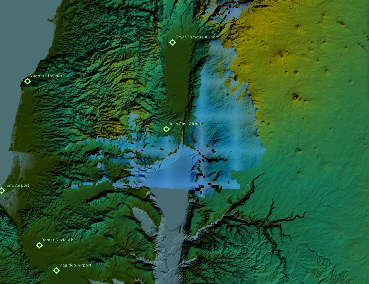
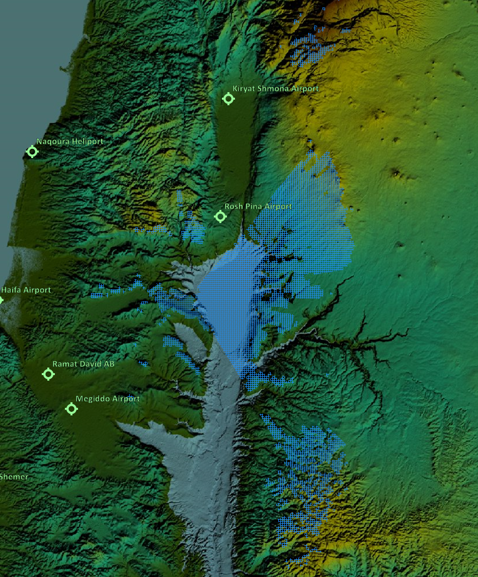
I wasn't available for Round One so this was my first go round for me or any of my group. Also, with regard as to why this came up, its because on our first sortie we were directed towards the Sea of Galilee by GCI and had very sparse radar coverage in an area that should have been well covered by radar. Its a flat body of water, after all. I was jumped by a Mig southwest of the Sea of Galilee that was not called by the game GCI or our human GCI. After I died, I hopped into a JTAC slot and got a first hand look at what was going on. Enemy aircraft at low level were disappearing as they crossed into the southern portion of the Sea of Galilee. Later engagements with no game GCI callouts or human GCI visibility of helicopters a few hundred feet off the ground between Naquora and Haifa told me their was no low level radar coverage there. This is what prompted me to investigate further. You have said twice now that "EWR's in DCS don't work like that". What exactly do you mean when you say that? Are you saying that line of sight from the antenna isn't relevant or is it something else you are referring to ?
-
By accuracy of the map, I mean the map matches what the EWR is "seeing". The map is radar line of sight at 100 ft AGL. That means that the radar will "see" an aircraft at 100 ft AGL in the colored areas and will not see aircraft at or below 100 ft AGL outside of the colored areas. We would get DCS GCI calls for aircraft departing King Hussein and Marj Ruhayyil and then the calls would stop as they descended to low level for ingress. We would get a few calls for aircraft on the eastern side of the border northwest of Rosh Pinar and then silence as they moved west or south. My experience as GCI showed we had a huge radar hole at the southern half of the Sea of Galilee and south. Mike Delta quite often had a clear scope while we were engaged in areas where I would have expected radar coverage, particularly on the northwest coast. After a few sorties, I stayed high and west, once I figured out we had extremely limited low level radar coverage and I needed to pull the Migs off the deck. We fly in VR so we don't type plus I doubt I would complain during a mission in any case. This is the appropriate forum for this sort of thing. It was noticeable enough to me to prompt making the maps to see for myself if my suspicions were correct. If the mission design requires limited low level radar coverage for Blue, then so be it. I don't have to like the mission.
-
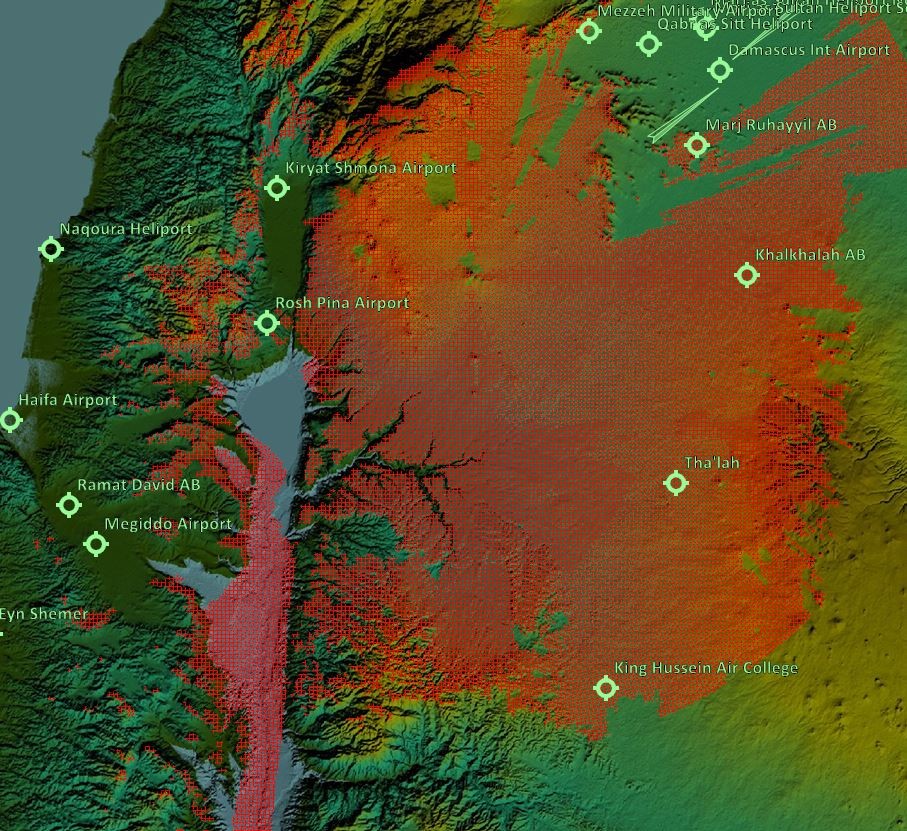
The maps reflect my experience in the mission pretty closely, from flying several sorties and sitting in the JTAC slot for Blue. Also, I have done these same sort of maps for several other missions and developed strike routes based on them. Flying those developed strike routes also closely matched the data created with maps like these, based upon what the RWR in the aircraft is indicating. Terrain masking certainly works and LOS seems to be the primary factor at play in radar detection. As an example, below is a map with a route I worked up for Into the Desert. You can see several spots along the route that cross red areas on the map. I flew the route in the server in the last two weeks. In those locations, the RWR indicated detection, outside of those areas the RWR was clean. I am pretty confident in the accuracy of the maps.
-
I found the mission fairly frustrating due to very poor radar coverage for Blue. To illustrate the point I created these radar Line of Sight images based upon the actual locations of the EWR antennas in the mission. They show radar line of sight at 100 feet AGL. The coverage at lower altitudes is significantly smaller but I think 100 AGL gives an adequate picture of the issue. One would think Blue would have a few more strategically located EWR systems. As you can see, there is a bit of a disparity.
-
Community A-4E-C v2.3 (May 2025)
=475FG= Dawger replied to plusnine's topic in Flyable/Drivable Mods for DCS World
This file occasionally causes an Integrity Check failure. Deleting it *seems* to have corrected it although I have only a few days of data with it removed. It took several days with the A-4E mod installed before this cropped up both times this has happened. I have no correlating events to point to why it happens when it happens.
-
@Alpenwolf In light of all the recent complaints, perhaps instead of addressing the symptoms, you could address the origin. It appears that Hind pilots are of the belief that their aircraft are invisible and invincible. So maybe removing the Mi24's from the missions is the simplest solution. An alternative is to swap the Hinds over to Blue and give Red the Gazelles. That way the complainers would be on the same side as the object of their complaints, minimizing this unnecessary distraction. I think a little mixing and matching of assets might do the server some good in breaking up some of the color loyalties. EDIT: Hinds for both sides is also a very realistic option. That would be a hoot, especially with helos hidden on the map. In fact, I think giving both sides all the helos would be lots of fun, at least from my viewpoint, high in the sky at Mach 1
-
I think he is taking issue with the availability of third person view in CA. I think the rationale is once you get in a vehicle, you cannot ever get out or get any visual information except through the optics available inside the tank. He is not.
-
A-10A and LGB - Is my memory going the way of the Dodo?
=475FG= Dawger replied to cfrag's topic in Mission Editor
See this -
replace request repair with request new plane
=475FG= Dawger replied to upyr1's topic in DCS Core Wish List
A new plane would require that the plane exist in the warehouse where you are at. If this is the case, there should be a slot for that new aircraft and you should just occupy that slot. If there are no aircraft in the warehouse where you are requesting one, repair should be your only option. The only scenario where this makes sense is when the mission designer places aircraft in the warehouse but does not provide slots to utilize them. I am not sure why a mission designer would choose to do that. -
Nope. You just add 1500 (or 1000 or 800 or whatever you like) ft to field elevation, fly that on the baro and call it good.
-
You may reference the above for the current status of visibility of helos in the F10 map.
-
@rogorogo I know you think that we have constant GCI surveillance of you in your Hind but that last kill before you quit today was because you sky lined yourself cresting a ridge in the desert map. We spotted you 30 miles out and then it was a simple matter of flying down the last bearing. We didn't know you were a helo until Dobs ID at 5 miles. Neither human or game GCI ever said a word about your presence. Mark I eyeball only. Hinds are not invisible.
-
There are any number of things that will cause a difference between radar altimeter and a barometric altimeter. You have to start from a point on the airport with a KNOWN elevation. The entire airport is not at the published elevation, only the designated point where the measurement was taken. Good luck finding that published point in DCS and you cannot assume what is on a real world chart will correspond to DCS. Once you find a known point elevation, park your airplane there and set the altimeter to match that elevation exactly. I would suggest pulling the center of the runway elevation from the F10 map. And then you would have to fly, straight and level over that point exactly to see if they match. If you are not straight and level, your radar altimeter will read higher than actual. Real airplanes are allowed 75 feet of error in the barometric altimeter and still be certified for instrument flight so I think you are engaging in an exercise in frustration in expecting to match the baro to the radar altimeter. There are a ton of environmental factors that introduce errors into the barometric altimeter and it is unknown how any of that is simulated in DCS.
-
Were you over precisely the same spot on the airport as that is all that is relevant for comparison?


.jpg.af1ad59e39f5c027a39530a26a426aa9.jpg)