Minsky
-
Posts
1692 -
Joined
-
Last visited
-
Days Won
2
Content Type
Profiles
Forums
Events
Everything posted by Minsky
-

Aerodrome Data and Frequencies - Updated 26 October 2025
Minsky replied to Minsky's topic in General Tutorials
Most certainly. I'm hoping to add Afghanistan in early August. -
Any Airfields Long Enough for an F18-C Hornet?
Minsky replied to WytchCrypt's topic in DCS: Normandy 2.0
Shameless plug, but this could've saved you some time: https://www.digitalcombatsimulator.com/en/files/3312200/ -
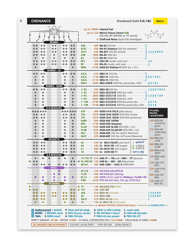
F/A-18C Kneeboard Suite - Updated 23 October 2025
Minsky replied to Minsky's topic in Utility/Program Mods for DCS World
Maybe someday, but not right now! Hornet's UI, at least to me, seems way easier than Warthog's, so I never felt the need for a HOTAS table. Just the joystick mapping diagram and a few A2A helpers, since I rarely do air combat and keep forgetting even the basics. -
If you can run Syria, then you should be more than fine with Sinai, especially in SP. This map can be described as 'Syria Lite': it looks simpler, but runs a bit smoother, and is less RAM-hungry. My specs are somewhat worse than yours, and I was able to comfortably fly Apache over Cairo (hands down the most built-up area in DCS) in pre-DLSS era. Although I would recommend waiting for the ever-coming Massive Sinai Update. Just to make sure they didn't push it too far with all the new stuff. I remember the devs themselves expressed concerns in that regard.
-
So, regarding that 'the map is so huge our engine can't handle the trip to the ocean' claim. This is the coast of Pakistan, about 250 nautical miles beyond the Afghanistan map boundary. Blurry textures and no mesh at all, but hey. All we need now is some water: the map has no 'global ocean', so that blue stuff is just a sludge texture.

-
The actual map, of course, spans further than that, especially eastward.
-
Can you please answer my question above? I believe it's important enough to be included in the FAQ as well.
-
How many air bases, airports currently in and how many are planned?
Minsky replied to Flogger23m's topic in South Atlantic
Also this: Aerodrome Data and Frequencies - Updated 22 May 2024 (digitalcombatsimulator.com) Don't know about what's planned, but I doubt we'll see many more. Simply because there are only a couple of paved aerodromes left within the map's current boundary, and they would've been added by now if the devs were intended to do so. The rest is smaller dirt and grass airfields of various levels of obscurity.- 1 reply
-
- 2
-

-

-
Because a unit can be spotted instantly, sparing you from doing pixel hunting with coordinates.
-
@BIGNEWY I searched, but couldn't find the answer. Are there any differences, besides cosmetic, between airfields in owned and not owned regions? I mean, if I don't own a region, will I be able to use its airfields just as usual in-game and in ME, or they will have limited functionality?
-
New Look and Feel for the South Atlantic map
Minsky replied to specterStudios's topic in South Atlantic
Can you give us some technical background for these? Are we looking at the updated mesh and textures? Or at the improvements to DCS engine that make everything "pop"? Or at 4fps with an extreme-ultra-mega-ultimate graphics preset? Or maybe at all that combined? -
Unmarked airport next to Lakatamia airstrip.
Minsky replied to LimePartician's topic in Bugs and Problems
It's Nicosia International Airport. Closed IRL, so yeah, it's unmarked and has no parking spots. -
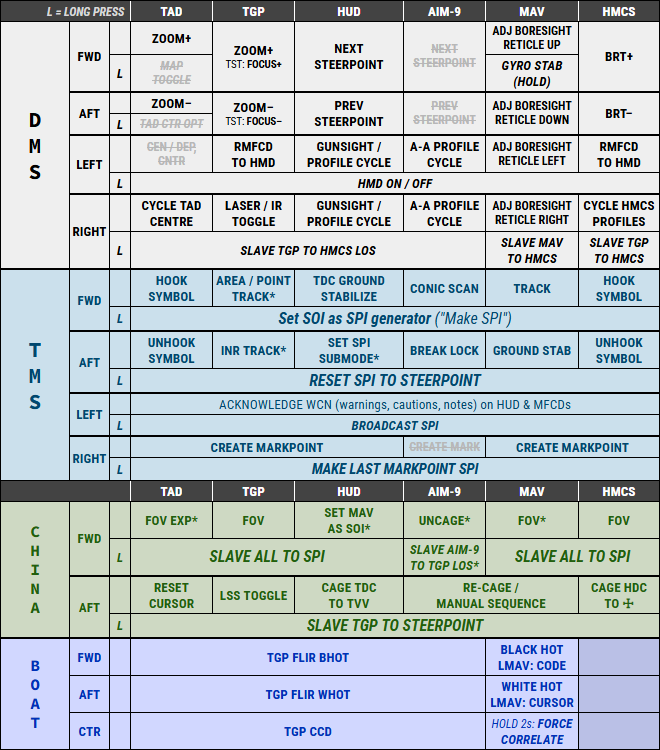
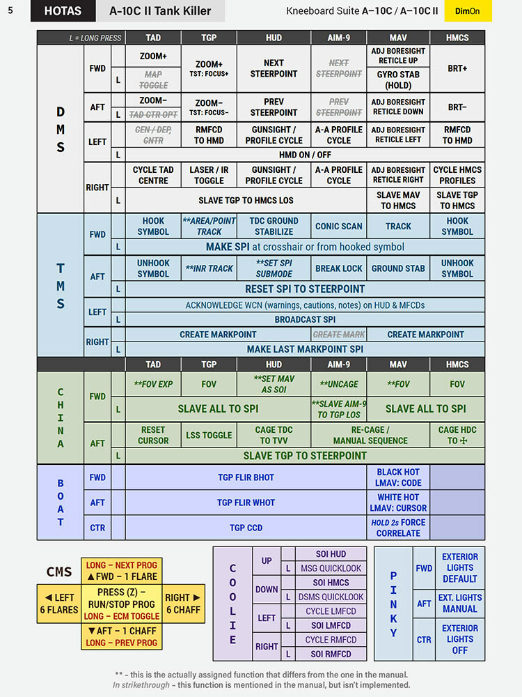
A-10C and A-10C II Kneeboard Suite - Updated 23 October 2025
Minsky replied to Minsky's topic in DCS: A-10C II Tank Killer
Hey, thanks for the suggestion! Your dispute about this back in the day was quite a read The very lenght of your post means that the concept of "SPI generator" can be hard to grasp, especially by novice players. The term is not commonly known, and only mentioned once (?) in the depths of the DCS manual, so it's easy to overlook. So I suggest we use both: the "proper" one, and the widely-used one for the reference.
-
A-10C and A-10C II Kneeboard Suite - Updated 23 October 2025
Minsky replied to Minsky's topic in DCS: A-10C II Tank Killer
Hi, sorry for replying so late. The HOTAS bindings for both modules are a little bit schizophrenic, and manuals (neither ED's nor the -1) cannot be trusted 100% I could reproduce both of your issues, and updated the kneeboards. Feel free to redownload. Please don't hesitate to report if you find more. Thanks!
-
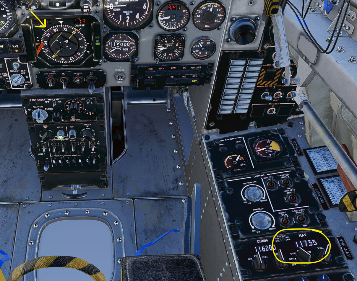
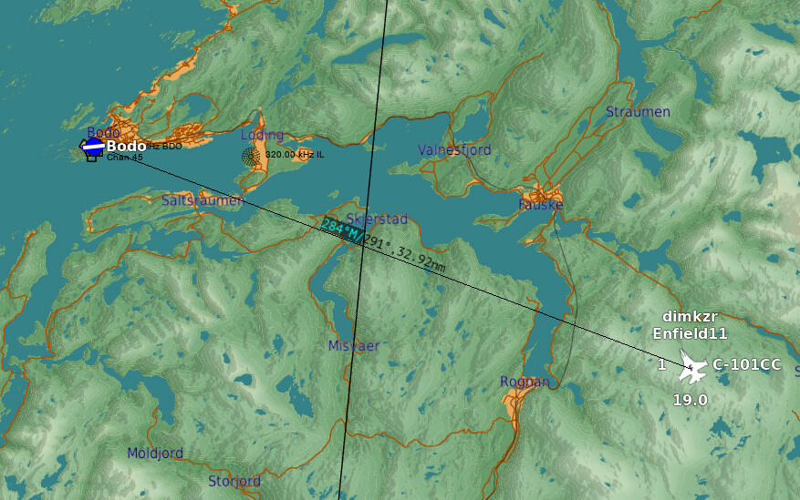
I just tested both VORs using the C-101, and they seem to work fine. Try starting in the air 20-30 miles away from Bodo. Just in case the Phantom is "filtering out" a very close (<1 nm) station, or in case you forgot to press some obscure button.
-
Raising the sea level in Caucasus looks great (mod)
Minsky replied to winghunter's topic in DCS: Caucasus
*Not yet Love the idea and the looks! I take it that most aerodromes ended up underwater? -
I should have put "primary" in quotes. Whille the ATC could apply its own rules to determine runway in use, many parts of DCS, including that info panel, are unaware that aerodromes can have multiple runways. And they pick whatever runway has the aerodrome symbol over it as their "primary". To summarize, there's nothing wrong with the ILS at Punta Arenas. But you can ask the devs to "move" aerodrome symbol to 07-25 to make the ILS info visible in the interface.
-
Yeah, but it's 12-30 in DCS. You can submit a new report and ask them to change it to 07-25.
-
Because that info panel has been designed in the LOMAC era and only shows info for the primary runway.
-
Looks like an ILS to me:
-
A-10C and A-10C II Kneeboard Suite - Updated 23 October 2025
Minsky replied to Minsky's topic in DCS: A-10C II Tank Killer
Fixed, thank you! -
I usually set up the E-2 and S-3 for an air start. (Just to get rid of them, but thankfully IRL they also takeoff before the main event begins.) Other than that, and me launching ASAP from a bow cat, the rest goes as it goes. And yes, for me it also happened after I launched: twice a Tomcat spawned behind the island and blocked other aircraft from getting to the waist cats.
-
F/A-18C Kneeboard Suite - Updated 23 October 2025
Minsky replied to Minsky's topic in Utility/Program Mods for DCS World
I just checked and it works fine, you don't even need to be logged in to download. Try clearing your browser's cache or using incognito mode to force-refresh the page. -
F/A-18C Kneeboard Suite - Updated 23 October 2025
Minsky replied to Minsky's topic in Utility/Program Mods for DCS World
Dirty liar! Upd: 1. Checklists, Quickstart, Ordnance >> Download from User Files << 25 May 2024 - Ordnance page: bomb fuzing options added. 3. RWR Threats, HARM Radar Codes >> Download from User Files << 25 May 2024 - Tiny update: Heatblur's Phantom added. It's not in the database yet, so Hornet's RWR displays it as an unknown contact.
-
It's great to hear from you and I'm glad the team is alright! I'm sure the update is worth the wait and wishing you luck finishing it (and a separate round of applause for adding Hurghada and Sharm )