Minsky
-
Posts
1696 -
Joined
-
Last visited
-
Days Won
2
Content Type
Profiles
Forums
Events
Everything posted by Minsky
-
Those are true headings, and so is 352° at Banak. The jet is showing you magnetic heading. 342° at Banak seems like a correct magnetic heading for a mission set between 2006 and 2010 when the magvar was approximately +10°
-
 I had the same problem until I fixed tanker waypoints (contrary to what you say, they were NOT set to same speed) and re-saved the mission without wake turbulence.
 -
Do yourself a favor and disable the wake turbulence in DCS settings. Then cycle through *all* tanker waypoints and set them to the same speed (I used 0.48 mach but that's just an arbitrary number). Like other people already told you, the tanker is rock steady. Play your own track and watch tanker's airspeed and altitude using the F2 camera. Then look at yours.
-
Hi, thanks for your response! I am aware that both airfields have unpaved runways. In DCS, however, it looks like a bug because the blurry satellite photo that goes as a "runway" doesn't match the rest of the aerodrome neither in pattern or in quality. And the taxiways are abruptly cut without any transition. Maybe try making runway more pronounced by adding a semi-transparent detail overlay? And/or make aprons and taxiways semi-transparent, so their underlying photo background could better blend with the runway.
-
They claim this for an empty map. Any decent mission and a full fidelity aircraft will require more for a smooth gameplay. And God forbid if you're running anything else in the background (like a browser).
-
Well, I have them all, and simply symlinked those I don't regularly use to a slower disk. No point in having older maps like Caucasus, PG and Nevada on a fancy M.2. There is another problem with these "new-gen" maps tho: they're quite RAM-hungry. With Syria you can almost get away with 32 Gb. Afghanistan and Iraq simply demand 64 Gb.
-
Not at the moment. ILS is not yet installed even on aerodromes that have it in real life.
-
Static Template for Kunar and Nuristan FOB's
Minsky replied to PeneCruz's topic in Missions and Campaigns
Seems like you're missing the required mods. Most likely this one: -
Aerodrome Data and Frequencies - Updated 26 October 2025
Minsky replied to Minsky's topic in General Tutorials
East Afghanistan update: > Download <- 206 replies
-
- 12
-

-

-
Is it supposed to look like this, or someone just mistook a common satellite imagery distortion for... whatever this is?
-
- 4
-
-
The runways at Khost airport and Khost Heliport are indeed missing:
-
That's "the tiny piece of the Gulf of Oman" I mentioned. The rest was added as a bonus. Sure, all this low-res terrain is practically useless to us. I'm just surprised there's so much of it. And the map runs better than ever, further debunking these "our engine can't handle this" claims.
-
As it turns out, alongside the tiny piece of the Gulf of Oman, ED has also sneaked in a bit more of the surrounding terrain in the latest patch. Sure, these are just blurry photos without any mesh or water, but it's a lot better than The Great Nothingness we had before. Here's the covered area: Dubai: Volgograd: India: Mongolia:
-
I wouldn't be surprised if that's just the good old Syria. Most of the shrub can be hidden by using the forest density slider and playing with FOV.
-
Do you have a mission demonstrating the issue or more details so it could be reproduced? I tried placing a cold A-10C at Creech (start from ramp) and they rearmed it just fine.
- 1 reply
-
- 1
-
-
I don't know what people think, but I was obviously joking. Trees can be a problem in certain circumstances (the Falklands map was, and maybe still is, plagued by a major performance hit when trees are backlit by the sun at specific angles), but on Marianas it's the general scenery complexity, like you said. Too many different objects confined on a tiny island.
-
You're overthinking it:
-
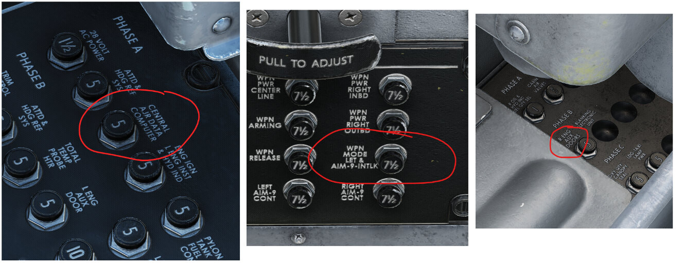
1. Left CB panel. "AIR" - not "AJR". 2. Forward CB panel. "SEL" - not "LET". 3. Right CB panel. "DOOR" - not "DOORS".

-
It can be scripted. Not sure if this mission still works, but when I tried it a couple years ago, the controller talked me down quite nicely: https://www.digitalcombatsimulator.com/en/files/3316436/ It would be nice to have PAR as part of the Core/revamped ATC.
-
DCS не видит пользовательские кампании
Minsky replied to SpecteRED's topic in Треки, Миссии и Кампании
Сейчас перенес нормально отображавшиеся кампании в \Campaigns\ - и они все пропали из списка. Не обязательно: только что скачал пару кампаний для модулей, которых у меня никогда не было - всё отображается. И только при попытке запуска вываливается ошибка про отсутствующий модуль. -
DCS не видит пользовательские кампании
Minsky replied to SpecteRED's topic in Треки, Миссии и Кампании
Перепроверьте путь: Saved Games\(DCS)\Missions\Campaigns\Язык\ПапкаКампании\ "Папка кампании" должна содержать файлы самих миссий и файл кампании с расширением .cmp Вместо "Язык" в норме должно быть три папки: "en", "MultiLang" и "ru". Если их нет - создайте. Потом закиньте папку кампании сперва в MultiLang, если не появится в игре - в ru, и наконец в en. На всякий случай уточню, что в самой игре пользовательские кампании находятся в Кампании > Мои кампании, а не в конкретных модулях. -
https://discord.com/invite/frHrekRbNA
-
That's the theoretical FPS your CPU could produce hadn't it been bottlenecked by the GPU. Or vice versa when CPU bound.
-
Couldn't find this reported.
-
Has it been acknowledged at all? It's 2025, and the issue still persists in the Remastered model.