okopanja
-
Posts
2067 -
Joined
-
Last visited
Content Type
Profiles
Forums
Events
Everything posted by okopanja
-
@Ironhandslighlty worse than you: https://snapshots.raintank.io/dashboard/snapshot/Trofr6wHWdBKim7gP65TrFsmoD0rd2U2
-
2.8 loading textures takes a loooooong time.
okopanja replied to Das Boot's topic in Game Performance Bugs
I think this occurs even when AH-64D is not flying at all (although to be best knowledge slot exists for AH-64D). -
The page mentions: "Quest 2 Gets New Lower Prices, Plus a Performance Upgrade". Any influence on DCS performance?
-
I think this was not stated in words but in a sinmple image reply. Later people quoted this as clear statement by DEKA.
-
Did you find any reference to the actual original climb profile. While the П-42 was actually a serial production airframe, it was also modified heavily. That said Streak eagle was also heavily modified. The way I see it you will end up creating a mod.
-
Likely kgf, DCS is metric internally. Needs to be crosschecked...
-
E.g. here is how hypothetical Mig-25 intercept would look like from rear aspect, add a 0.6-0.8 Mach on top. Notice that other Su-27 with full missile load , being actually out-accelerated by eagle. At the same time, carrying 2xR-27T and 2xR-27R allows you to catch up with the target.
-
Forgot to tell you that soviet variant was not only voice GCI, but also had воздух-1 command system. This means it could have been allocated a target from ground, thus some computer was in the aircraft, but not what we understand today. As for multiple launch, this was probably not possible against multiple targets. E.g. Mig-25 that took out FA-18 was armed with 2xR-40RD missiles and it fired only one which practically disintegrated hornet. If I remember correctly this engagement took place in night conditions. Pilot considered attacking second FA-18, but got GCI order to return. It is worth to note that another Mig-25 got shotdown by FA-18, when it actually went into close air combat. Book describes accounts from both side, since author made great effort to collect feedback from both sides. His books tend not to be single side propaganda fairy-tales. Reading this book made me rethink the way I fight in a flanker (used to be full load, now I carry 2-4 missiles, and this results in drastically different aircraft performance). You could say that I fight the Mig-25 way (above Mach 2 when attacking) and do not pull lot's of G. This means that I do not bleed energy when turning away to escape superior ARH missiles. I found out that this tactic works actually pretty well on the average, even in the modern environment. The additional benefit for co-fliers is that usually large number of missiles get launched (everyone see one large PK circle, that suddenly starts shrinking). Flying Mig-25 would require you to be aware of your fuel state, and be realistic on what you can attempt to do (attack from distance but not on direct path) and what not (do not come close). I do believe it would be fun to fly aircraft capable of reaching Mach 2.8+ in DCS.
-
Actually this is one of popular myths. The aircraft was designed to be high speed interceptor, but it's shape and secrecy made many attribute him fighter role. For what it was design for it did well, except that treath it was supposed to counter turned out to be a disaster project. Not really original Mig-25 had a RP-25 Smerch A1 (600kW) radar which was a pulse radar. These were delivered to Iraq mid-80s along R-40 missiles. By that time it was know that A2 was compromised due to the Belenko's flight to Japan in 1976. Upon complaints Soviets were forced to upgrade the aircraft to Smerch A2 radar (better jamming resistance, increased reliability, look down and better low level clutter tolerance) + deliver R-40RD and R-40TD missiles. These were known as Mig-25 PDS. Radar was in I-band low PRF pulse and had similar performance as F-4D's AN/APQ-109 3rd radar was modification of Saphir-25, marked as RP-25M. It increased the range further. (book page 26, 27). A curiosity of the Mig-25 was that they carried 2xR-40RD and 2x-40TD. Both TD and TR were slaved by radar to target and upon launching the TD would launch first, followed by TR. The missile was capable of up to mach 5, and had range of about 50km.
-
You can get rid of pylons on positions 3 and 8, by placing double racks and dropping them, but this sadly does not change drag. (measured this!) Pylons are simply modeled in.
-
There is a nice book written by Douglas C Dildy & Tom Cooper: "F-15C Eagle vs Mig-23/25". You might want to check it out.
-
Likely module would need to model each variant separately just like gazelle does.
-
Point of view:
-
fixed PATRIOT has grossly overestimated launch range
okopanja replied to Default774's topic in Ground AI Bugs (Non-Combined Arms)
Stop derailing the topic. Patriot in DCS had obviosly bad performance for long time. I think it is good that it got fixed. However it is wrong to request more without providing evidence and bringing further unrelated claims. Comparing two very much different missiles based purely on relative DCS performance, is also wrong if person does not provide solid evidence or detailed calculation that proves ED' calculations are wrong. So, show us the math. Anything else is crude attempt to upvote the case. -
fixed PATRIOT has grossly overestimated launch range
okopanja replied to Default774's topic in Ground AI Bugs (Non-Combined Arms)
Trying to figure out your thought process, but I fail to see any coherence. Mixing unrelated events and not even being able to quote them correctly. Can you show us the targets that got down during last salvo launch? -
Thanks, I did not know this.
-
https://en.wikipedia.org/wiki/Infrared_search_and_track @bies I was not aware of IRST on Mig-25, do you have picture, article, reference? Where was it located? I believe it was used to bomb Teheran though lofting of bombs tens of km at high speed. Accuracy was probably not great. Running away was a real tactic, as well as notching and arriving at crazy speeds... However, it likely did score against FA-18 (single launch and hit with R-40RD, pilot got recalled when he considered going after another one) and likely damaged or shotdown F-15C - very little to no evidence exist, potential wreckage may have been picked up, so maybe in 50 years we will know. The upgraded variant of aircraft is probably still considered sensitive and still serves in at least Algerian Air Force.
-
Shark Planner: waypoint entry into Ka-50 ABRIS and PVI-800 from F10
okopanja replied to okopanja's topic in DCS Modding
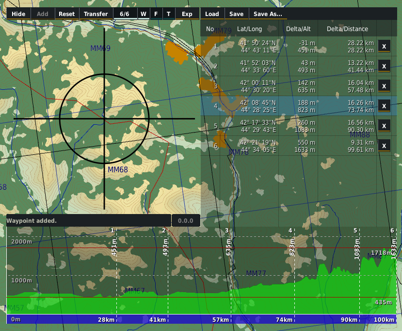
Hi All, As promised elevation profile has been implemented. Feedback in form of bugs/improvements/ideas is appreciated. v1.2.0 What's Changed Added elevation profile chart by @okopanja in #50 Shows elevation profile along lines connecting waypoints. Green area represents ground, blue represents sea. Elevations are sampled at 1m step Averaged for display reasons with math.max function. we can not show each m of route, so for given minimal display interval the highest value is selected. At least one waypoint must be added (or 2 in case CA JTAC) Each waypoint is represented with vertical dashed white line with: Ordinal number at top Altitude (m) below top Distance (km) at bottom Automatically updates on add/remove reset waypoints. This process takes a second on my PC, please let me know if delays are to severe. Displays maximum elevation line with altitude in meters (red line) Displays minimal elevation line with elevation in meters (red line) Displays thousands of meters up to the next above maximal elevation Limitations: Text may overlap if waypoints are placed to close, while having many times more remote waypoints Made waypoint list more readable by adding shadow to the text #52 Made experimental button permanent, but concealed (not for end users) in #49 Full Changelog: v1.1.0...v1.2.0
-
Today’s DCS newsletter mentioned “tunnels under Paris”…
okopanja replied to Barrett_g's topic in DCS: Normandy 2.0
There are old abandoned railroad tracks that re not in use in Paris anymore. it is not easy to access them nowadays, but they still exists. -
I would expect that core 2011 works including slewing. I did not ask for iglas, although they provide certain fun to use. I hope the devs will find the way for this to work without endangering the realism levels.
-
I would not mix IRL and BS3 to draw analogies. For first we do no have actual block diagrams or really solid set of data on it. To me it actually feels as module itself was never finished fully. As for the BS3, nobody expects it to outperform Apache, but this is after all a $70 module, if there is a feature it should work within reasonable levels with limited period of time. It would certainly not step away from realism, since INU will cause the drifting and therefore decreased accuracy of slewing. At present this works properly only near the coast and at altitudes of 40-70m.
-
You can slew the to 0, and them move it up until laser designator shows expected range... You can also asume based on altitude...
-
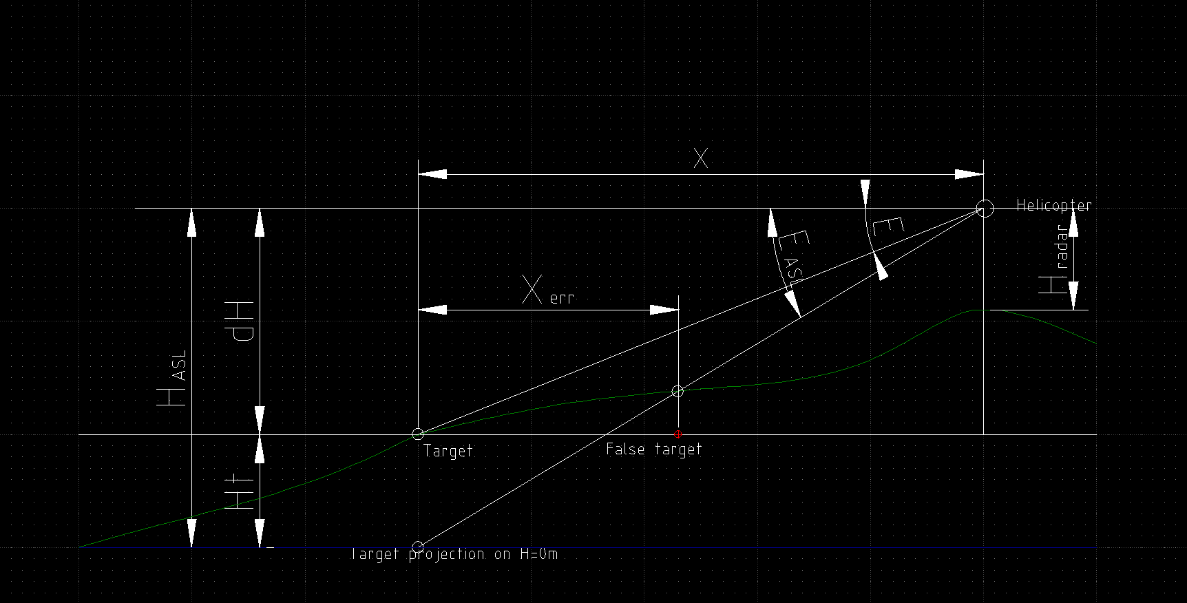
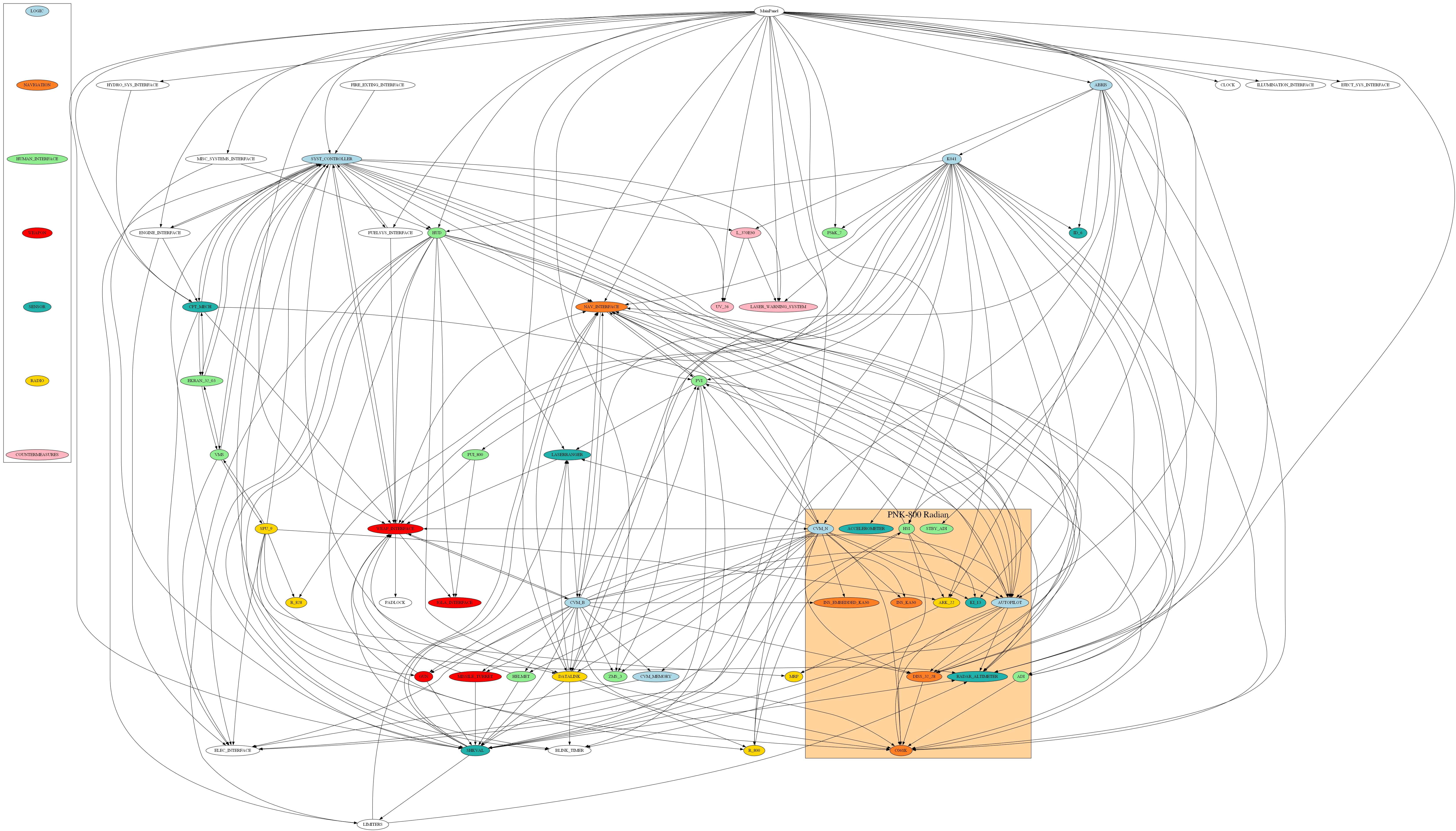
Yes, this appears to be Rubikon originated, which makes me wonder why it has some features that do not work at all or not properly. E.g. steering shkval based on navpoint location to 0m is totally senseless. I do not expect to have the target locked, but at least it should be in the FOV of shkval, and not under ground. ABRIS actually looks into ID-6 device: "electromagnetic detector" and it looks into Rubikon K-041 See svg by downloading and opening into web browser (it has tooltips) for what I have gotten from lua files. google translate: Да, это похоже на Рубикон, что заставляет меня задаться вопросом, почему некоторые функции не работают вообще или работают неправильно. Например. рулить шквалом по местоположению навигационной точки на 0м совершенно бессмысленно. Я не ожидаю, что цель будет захвачена, но, по крайней мере, она должна быть в поле зрения шквала, а не под землей. АБРИС реально смотрит в прибор ИД-6: "электромагнитный детектор" и он смотрит в Рубикон К-041 Посмотрите svg, загрузив и открыв в веб-браузере (у него есть всплывающие подсказки), чтобы узнать, что я получил из файлов lua. ka-50.svg
-
FUD
-
Original: If this is true, why is then yellow designation showing incorrect ranges compared to IT-23, when the system knows precise position and ABRIS angles, I would expect to be able position yellow mark on top of target in ABRIS and have target roughly within the view of IT-23. Interesting it gets worse the higher the altitude is. Surely this is a bug? Google translation: Если это так, то почему тогда желтое обозначение показывает неправильные дальности по сравнению с ИТ-23, когда система знает точное положение и углы ABRIS, я ожидаю, что смогу разместить желтую метку поверх цели в ABRIS и получить цель примерно в пределах вид ИТ-23. Интересно, чем выше высота, тем хуже. Это точно баг?